
.gif)
Miami River (Florida)
Encyclopedia
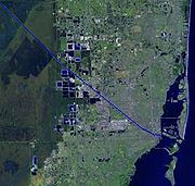
The Miami River is a river in the United States state of Florida
that drains out of the Everglades
and runs through the Downtown
and the city of Miami. The 5.5 miles (8.9 km) long river flows from the terminus of the Miami Canal
at Miami International Airport
to Biscayne Bay
. It was originally a natural river inhabited at its mouth by the Tequesta
Indians, but it was dredged and is now polluted because of its route through Miami-Dade County
. The mouth of the river is now home to the Port of Miami
and many other businesses whose pressure to maintain it has helped to improve the river's condition.
word that means "sweet water", the earliest mention of the name comes from Hernando de Escalante Fontaneda
, a captive of Indians in southern Florida for 17 years, when he referred to what is now Lake Okeechobee
as the "Lake of Mayaimi
, which is called Mayaimi because it is very large". Spanish records include the cacique of 'Maimi' in a group of 280 Florida Indians that arrived in Cuba in 1710. Reports on a Spanish Mission to the Biscayne Bay area in 1743 mention 'Maymies' or 'Maimíes' living nearby. The river has also been known as the Garband River, Rio Ratones, Fresh Water River, Sweetwater River, and Lemon River. It has been known as the Miami River since the Second Seminole War
of 1835–42.
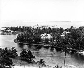
 In its original natural state, the river started at rapids formed by water from the Everglades flowing over a rocky ledge four miles (6.4 km) from its mouth. Frederick H. Gerdes of the U.S. Coast Survey
reported in 1849 that "[f]rom the upper falls to near its entrance into Key Biscayne Bay… water in the Glades was 6 feet 2.5 inches (1.89 m) above low tide." The rapids were removed when the Miami Canal was dredged in an attempt to drain the wetland
.
The river divided into a North Fork and a South Fork about three miles (4.8 km) above its mouth. Each fork extended only one mile (1.6 km) to rapids marking the edge of the Everglades. The North Fork had the greater flow and the higher drop over its rapids. One-and-one-half miles (2.4 km) above the mouth of the river there was a tributary on the north side, called Wagner Creek, which was about two miles (3.2 km) long. The Miami River was also fed by several springs, including some in the bed of the river. Flow was variable and in times of drought sometimes stopped completely.
 The earliest known inhabitants of the area around the Miami River were the Tequesta
s. Their major town at the time of first European contact was on the north bank of the river near the mouth. Before the intensive development of Miami in the 20th century, mound
s built by the Tequesta were located along the river. Spanish missions were briefly established beside the river in 1567–70 and in 1743, but the area was abandoned when Spain turned Florida over to Britain
in 1765.
The area around the Miami River attracted settlers throughout the 19th century, with the major exception of the years of the Seminole Wars
, but had little effect on the river. The US Army tried to dig a channel through the sandbar at the mouth of the river in 1856 but stopped when it was decided that Fort Dallas
would not be made permanent.
 Modification of the river began in earnest with the arrival of the Florida East Coast Railway
in Miami in 1896. There was much dredging and filling along the river. The rapids at the head of the South Fork were removed in 1908. From 1909 to 1912, the Miami Canal was dug, bypassing the rapids at the head of the North Fork. The canal was dammed off from the river for most of the construction period. When the canal was opened to the river in March 1912 large amounts of Everglades muck
and finely ground stone from the dredging were washed down the river, silting it. As a result, the lower river had to be dredged three times in two years.
Dredging of the river and of canals connecting to the river continued into the 1930s. Deepening the Miami River (and other streams and canals draining into Biscayne Bay), as well as the drainage of the Everglades that was a major purpose of the dredging, led to saltwater intrusion
in the area, forcing the abandonment of drinking water wells on several occasions. By the 1940s, dams were being installed on the canals leading into the Miami River to prevent salt water from traveling inland.
The Miami River also became polluted. In 1897, Miami's first sewer line started emptying directly into the river. By the 1950s, 29 sewers were dumping untreated sewage into the river. Dade County constructed a sewage treatment plant on Virginia Key
in the 1950s and started connecting sewer lines to it, a project that took many years.
 The Miami River has long been home to many small cargo terminals at which smaller ships (up to about 230 feet (70 m) in length) call to load cargo, most of which is destined for ports in the Bahamas and various Caribbean nations. It is also an area into which all manner of contraband—illegal drugs, illegal aliens—has been discharged into the US. Because of continuing efforts by the United States Coast Guard
, U.S. Bureau of Immigration and Customs Enforcement (ICE), DEA and other agencies, the illicit trade has been minimized in recent years.
Although the part of the river from Northwest 36th Street to its mouth is still polluted, this has been mitigated considerably by rigid enforcement of both international and US laws regarding discharge of oil and sewage by ships as well as of laws addressing industrial dumping. The muddy bottom, however, is still reported to contain undesirable substances in significant quantities.
In years past, many vessels docked in the river at the ends of their last voyages were abandoned and sank alongside the docks, creating eyesores and hazards to navigation. Those derelicts have been removed.
Invoking the authority of Port State Control, the US Coast Guard now vigorously enforces the many international and national regulations regarding safety equipment, construction, maintenance, and manning of ships entering all US ports including the Miami River, virtually eliminating the many dangerously substandard vessels that had sailed from the US in previous years.
In recent years, realizing they had common interests, various business entities along the river formed the Miami River Group. The group works closely with local law enforcement agencies, the US Coast Guard, ICE, and others to maintain clear channels of communication and cooperation. It now acts much as one port with numerous port facilities and support entities such as agents, surveyors, consultants, naval architects and engineers, and ship and machinery repair businesses.
Many of the ships sailing from the Miami River carry much needed cargo to ports in Haiti
including Port-au-Prince
, Miragoâne
, Cap-Haïtien
, Port-de-Paix
, Saint-Marc
, Gonaïves
, and Jacmel
. Their cargo typically consist of dry foodstuffs such as beans and rice, canned goods, clothing, household goods and appliances, and used cars, trucks, and buses.
In times past, some of the cargo terminals on the river were areas of lawlessness. Law enforcement and regulatory agencies have eliminated most of that sort of activity. When the International Ship and Port Security Code and the U.S. Maritime Transportation Act of 2002 came into force (and in the prior runup) on July 1, 2004, most opportunities for crime were eliminated.
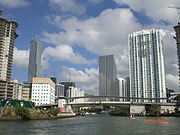
Some of the terminals and other business related to cargo shipping on the "lower end" of the river near downtown Miami have been eliminated or moved farther upstream because of illicit shipping activities. The "lower end" of the river has been the subject of much renovation and building of high rise offices, hotels, and living structures.
25°46′10"N 80°11′31"W
Florida
Florida is a state in the southeastern United States, located on the nation's Atlantic and Gulf coasts. It is bordered to the west by the Gulf of Mexico, to the north by Alabama and Georgia and to the east by the Atlantic Ocean. With a population of 18,801,310 as measured by the 2010 census, it...
that drains out of the Everglades
Everglades
The Everglades are subtropical wetlands in the southern portion of the U.S. state of Florida, comprising the southern half of a large watershed. The system begins near Orlando with the Kissimmee River, which discharges into the vast but shallow Lake Okeechobee...
and runs through the Downtown
Downtown Miami
Downtown Miami is an urban residential neighborhood, and the central business district of Miami, Miami-Dade County, and South Florida in the United States...
and the city of Miami. The 5.5 miles (8.9 km) long river flows from the terminus of the Miami Canal
Miami Canal
The Miami Canal, or C-6 Canal, flows from Lake Okeechobee in the U.S. state of Florida to its terminus at the Miami River, which flows through downtown Miami. The canal flows in a south and southeasterly direction for approximately 77 miles, and passes through three counties: Broward, Palm Beach,...
at Miami International Airport
Miami International Airport
Miami International Airport , also known as MIA and historically Wilcox Field, is the primary airport serving the South Florida area...
to Biscayne Bay
Biscayne Bay
Biscayne Bay is a lagoon that is approximately 35 miles long and up to 8 miles wide located on the Atlantic coast of South Florida, United States. It is usually divided for purposes of discussion and analysis into three parts: North Bay, Central Bay, and South Bay. Its area is...
. It was originally a natural river inhabited at its mouth by the Tequesta
Tequesta
The Tequesta Native American tribe, at the time of first European contact, occupied an area along the southeastern Atlantic coast of Florida...
Indians, but it was dredged and is now polluted because of its route through Miami-Dade County
Miami-Dade County, Florida
Miami-Dade County is a county located in the southeastern part of the state of Florida. As of 2010 U.S. Census, the county had a population of 2,496,435, making it the most populous county in Florida and the eighth-most populous county in the United States...
. The mouth of the river is now home to the Port of Miami
Port of Miami
The Dante B. Fascell Port of Miami is a seaport located in Biscayne Bay in Miami, Florida, United States. It is connected to Downtown Miami by Port Boulevard, a bridge over the Intracoastal Waterway. The port is located on Dodge Island, which is the combination of three historic islands that have...
and many other businesses whose pressure to maintain it has helped to improve the river's condition.
Etymology
Although it is widely believed that the name is derived from a Native AmericanNative Americans in the United States
Native Americans in the United States are the indigenous peoples in North America within the boundaries of the present-day continental United States, parts of Alaska, and the island state of Hawaii. They are composed of numerous, distinct tribes, states, and ethnic groups, many of which survive as...
word that means "sweet water", the earliest mention of the name comes from Hernando de Escalante Fontaneda
Hernando de Escalante Fontaneda
Hernando de Escalante Fontaneda was a Spanish shipwreck survivor who lived among the Indians of Florida for 17 years...
, a captive of Indians in southern Florida for 17 years, when he referred to what is now Lake Okeechobee
Lake Okeechobee
Lake Okeechobee , locally referred to as The Lake or The Big O, is the largest freshwater lake in the state of Florida. It is the seventh largest freshwater lake in the United States and the second largest freshwater lake contained entirely within the lower 48 states...
as the "Lake of Mayaimi
Mayaimi
The Mayaimi were a Native American people who lived around Lake Okeechobee in Florida from the beginning of the Common Era until the 17th or 18th century. The group took their name from the lake, which was then called Mayaimi, which meant "big water" in the language of the Mayaimi, Calusa, and...
, which is called Mayaimi because it is very large". Spanish records include the cacique of 'Maimi' in a group of 280 Florida Indians that arrived in Cuba in 1710. Reports on a Spanish Mission to the Biscayne Bay area in 1743 mention 'Maymies' or 'Maimíes' living nearby. The river has also been known as the Garband River, Rio Ratones, Fresh Water River, Sweetwater River, and Lemon River. It has been known as the Miami River since the Second Seminole War
Second Seminole War
The Second Seminole War, also known as the Florida War, was a conflict from 1835 to 1842 in Florida between various groups of Native Americans collectively known as Seminoles and the United States, part of a series of conflicts called the Seminole Wars...
of 1835–42.
Natural river
U.S. National Geodetic Survey
National Geodetic Survey, formerly called the U.S. Coast and Geodetic Survey , is a United States federal agency that defines and manages a national coordinate system, providing the foundation for transportation and communication; mapping and charting; and a large number of applications of science...
reported in 1849 that "[f]rom the upper falls to near its entrance into Key Biscayne Bay… water in the Glades was 6 feet 2.5 inches (1.89 m) above low tide." The rapids were removed when the Miami Canal was dredged in an attempt to drain the wetland
Wetland
A wetland is an area of land whose soil is saturated with water either permanently or seasonally. Wetlands are categorised by their characteristic vegetation, which is adapted to these unique soil conditions....
.
The river divided into a North Fork and a South Fork about three miles (4.8 km) above its mouth. Each fork extended only one mile (1.6 km) to rapids marking the edge of the Everglades. The North Fork had the greater flow and the higher drop over its rapids. One-and-one-half miles (2.4 km) above the mouth of the river there was a tributary on the north side, called Wagner Creek, which was about two miles (3.2 km) long. The Miami River was also fed by several springs, including some in the bed of the river. Flow was variable and in times of drought sometimes stopped completely.
History
Tequesta
The Tequesta Native American tribe, at the time of first European contact, occupied an area along the southeastern Atlantic coast of Florida...
s. Their major town at the time of first European contact was on the north bank of the river near the mouth. Before the intensive development of Miami in the 20th century, mound
Mound
A mound is a general term for an artificial heaped pile of earth, gravel, sand, rocks, or debris. The most common use is in reference to natural earthen formation such as hills and mountains, particularly if they appear artificial. The term may also be applied to any rounded area of topographically...
s built by the Tequesta were located along the river. Spanish missions were briefly established beside the river in 1567–70 and in 1743, but the area was abandoned when Spain turned Florida over to Britain
Kingdom of Great Britain
The former Kingdom of Great Britain, sometimes described as the 'United Kingdom of Great Britain', That the Two Kingdoms of Scotland and England, shall upon the 1st May next ensuing the date hereof, and forever after, be United into One Kingdom by the Name of GREAT BRITAIN. was a sovereign...
in 1765.
The area around the Miami River attracted settlers throughout the 19th century, with the major exception of the years of the Seminole Wars
Seminole Wars
The Seminole Wars, also known as the Florida Wars, were three conflicts in Florida between the Seminole — the collective name given to the amalgamation of various groups of native Americans and Black people who settled in Florida in the early 18th century — and the United States Army...
, but had little effect on the river. The US Army tried to dig a channel through the sandbar at the mouth of the river in 1856 but stopped when it was decided that Fort Dallas
Fort Dallas
Fort Dallas is a urban park in the Lummus Park Historic District of Miami, Florida, just west of Downtown. It once acted as a military base during the Seminole Wars, located on the banks of the Miami River in what is now Downtown, Miami, Florida, United States....
would not be made permanent.
Dredging and pollution
Florida East Coast Railway
The Florida East Coast Railway is a Class II railroad operating in the U.S. state of Florida; in the past, it has been a Class I railroad.Built primarily in the last quarter of the 19th century and the first decade of the 20th century, the FEC was a project of Standard Oil principal Henry Morrison...
in Miami in 1896. There was much dredging and filling along the river. The rapids at the head of the South Fork were removed in 1908. From 1909 to 1912, the Miami Canal was dug, bypassing the rapids at the head of the North Fork. The canal was dammed off from the river for most of the construction period. When the canal was opened to the river in March 1912 large amounts of Everglades muck
Muck (soil)
Muck is a soil made up primarily of humus from drained swampland. It is known as black soil in The Fens of eastern England, where it was originally mainly fen and bog. It is used there, as in the United States, for growing specialty crops such as onions, carrots, celery, and potatoes...
and finely ground stone from the dredging were washed down the river, silting it. As a result, the lower river had to be dredged three times in two years.
Dredging of the river and of canals connecting to the river continued into the 1930s. Deepening the Miami River (and other streams and canals draining into Biscayne Bay), as well as the drainage of the Everglades that was a major purpose of the dredging, led to saltwater intrusion
Saltwater intrusion
Saltwater intrusion is the movement of saline water into freshwater aquifers. Most often, it is caused by ground-water pumping from coastal wells, or from construction of navigation channels or oil field canals. The channels and canals provide conduits for salt water to be brought into fresh...
in the area, forcing the abandonment of drinking water wells on several occasions. By the 1940s, dams were being installed on the canals leading into the Miami River to prevent salt water from traveling inland.
The Miami River also became polluted. In 1897, Miami's first sewer line started emptying directly into the river. By the 1950s, 29 sewers were dumping untreated sewage into the river. Dade County constructed a sewage treatment plant on Virginia Key
Virginia Key
Virginia Key is a barrier island in Miami, Florida, United States in Biscayne Bay, south of Brickell and north of Key Biscayne. It accessible from the mainland via the Rickenbacker Causeway....
in the 1950s and started connecting sewer lines to it, a project that took many years.
Commercial use
United States Coast Guard
The United States Coast Guard is a branch of the United States Armed Forces and one of the seven U.S. uniformed services. The Coast Guard is a maritime, military, multi-mission service unique among the military branches for having a maritime law enforcement mission and a federal regulatory agency...
, U.S. Bureau of Immigration and Customs Enforcement (ICE), DEA and other agencies, the illicit trade has been minimized in recent years.
Although the part of the river from Northwest 36th Street to its mouth is still polluted, this has been mitigated considerably by rigid enforcement of both international and US laws regarding discharge of oil and sewage by ships as well as of laws addressing industrial dumping. The muddy bottom, however, is still reported to contain undesirable substances in significant quantities.
In years past, many vessels docked in the river at the ends of their last voyages were abandoned and sank alongside the docks, creating eyesores and hazards to navigation. Those derelicts have been removed.
Invoking the authority of Port State Control, the US Coast Guard now vigorously enforces the many international and national regulations regarding safety equipment, construction, maintenance, and manning of ships entering all US ports including the Miami River, virtually eliminating the many dangerously substandard vessels that had sailed from the US in previous years.
In recent years, realizing they had common interests, various business entities along the river formed the Miami River Group. The group works closely with local law enforcement agencies, the US Coast Guard, ICE, and others to maintain clear channels of communication and cooperation. It now acts much as one port with numerous port facilities and support entities such as agents, surveyors, consultants, naval architects and engineers, and ship and machinery repair businesses.
Many of the ships sailing from the Miami River carry much needed cargo to ports in Haiti
Haiti
Haiti , officially the Republic of Haiti , is a Caribbean country. It occupies the western, smaller portion of the island of Hispaniola, in the Greater Antillean archipelago, which it shares with the Dominican Republic. Ayiti was the indigenous Taíno or Amerindian name for the island...
including Port-au-Prince
Port-au-Prince
Port-au-Prince is the capital and largest city of the Caribbean nation of Haiti. The city's population was 704,776 as of the 2003 census, and was officially estimated to have reached 897,859 in 2009....
, Miragoâne
Miragoane
Miragoâne is a coastal town in western Haïti and the capital of the Nippes Department. It is regarded as one of the major ports in the trade in used goods. Bales of used clothing, shoes, appliances and used cars arrive at the port from Miami and other U.S. cities. Local merchants in the informal...
, Cap-Haïtien
Cap-Haïtien
Cap-Haïtien is a city of about 190,000 people on the north coast of Haiti and capital of the Department of Nord...
, Port-de-Paix
Port-de-Paix
Port-de-Paix is a city and the capital of the département of Nord-Ouest in Haïti on the Atlantic coast. It has a population of 250,000 ....
, Saint-Marc
Saint-Marc
Saint-Marc is a coastal port town in western Haiti in the Artibonite Department. Its geographic coordinates are . At the 2003 Census the municipality had 160,181 inhabitants....
, Gonaïves
Gonaïves
Gonaïves is a city in northern Haiti, the capital of the Artibonite Department. It has a population of about 104,825 people . The city's name derives from the original Amerindian name of Gonaibo. It is also known as Haïti's "independence city"...
, and Jacmel
Jacmel
Jacmel, also known by its indigenous Taíno name of Yaquimel, is a town in southern Haiti founded in 1698. It is the capital of the department of Sud-Est and has an estimated population of 40,000, while the municipality of Jacmel had a population of 137,966 at the 2003 Census.The buildings are...
. Their cargo typically consist of dry foodstuffs such as beans and rice, canned goods, clothing, household goods and appliances, and used cars, trucks, and buses.
In times past, some of the cargo terminals on the river were areas of lawlessness. Law enforcement and regulatory agencies have eliminated most of that sort of activity. When the International Ship and Port Security Code and the U.S. Maritime Transportation Act of 2002 came into force (and in the prior runup) on July 1, 2004, most opportunities for crime were eliminated.
Some of the terminals and other business related to cargo shipping on the "lower end" of the river near downtown Miami have been eliminated or moved farther upstream because of illicit shipping activities. The "lower end" of the river has been the subject of much renovation and building of high rise offices, hotels, and living structures.
External links
- Miami-Dade History
- U.S. Army Corps of Engineers Dredging Page
- Miami River Commission
- Water Quality Report
- City of Miami's Miami River Development Plan
25°46′10"N 80°11′31"W