

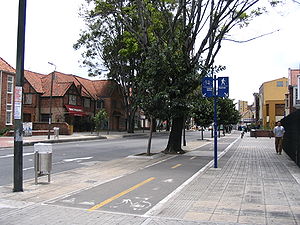
Segregated cycle facilities
Encyclopedia
Cycling
Cycling, also called bicycling or biking, is the use of bicycles for transport, recreation, or for sport. Persons engaged in cycling are cyclists or bicyclists...
from which motorised traffic is generally excluded. The term includes bike lanes, cycle tracks/separated bike lanes, road shoulders and side paths located within a road right-of-way.
The names and definitions of the various cycle facility types vary from country to country, but besides local naming conventions, one of the main subdivisions is whether the facility is physically separated by barriers, parking or bollards from other (especially motor vehicle) traffic, or whether the segregation is due to painted markings. The facilities have been modified over time and increased in variety as usage changes, and as cities receive feedback and experiment with improvements.
Bike lanes and road shoulders demarcated by a painted marking are quite common both in many European and American cities. Segregated cycle facilities demarcated by barriers, bollards or boulevards are quite common in some European countries such as the Netherlands
Cycling in the Netherlands
Cycling in the Netherlands is a common and popular method of both transport and also recreation. The country is well equipped with cycle-paths and other segregated cycle facilities. The network reaches all parts of the nation and into the bordering nations of Belgium and Germany...
, Denmark and Germany
Germany
Germany , officially the Federal Republic of Germany , is a federal parliamentary republic in Europe. The country consists of 16 states while the capital and largest city is Berlin. Germany covers an area of 357,021 km2 and has a largely temperate seasonal climate...
. They are also increasingly being installed in other major cities such as New York City
New York City
New York is the most populous city in the United States and the center of the New York Metropolitan Area, one of the most populous metropolitan areas in the world. New York exerts a significant impact upon global commerce, finance, media, art, fashion, research, technology, education, and...
, Bogotá
Bogotá
Bogotá, Distrito Capital , from 1991 to 2000 called Santa Fé de Bogotá, is the capital, and largest city, of Colombia. It is also designated by the national constitution as the capital of the department of Cundinamarca, even though the city of Bogotá now comprises an independent Capital district...
, Melbourne
Melbourne
Melbourne is the capital and most populous city in the state of Victoria, and the second most populous city in Australia. The Melbourne City Centre is the hub of the greater metropolitan area and the Census statistical division—of which "Melbourne" is the common name. As of June 2009, the greater...
, Vancouver
Vancouver
Vancouver is a coastal seaport city on the mainland of British Columbia, Canada. It is the hub of Greater Vancouver, which, with over 2.3 million residents, is the third most populous metropolitan area in the country,...
, Ottawa
Ottawa
Ottawa is the capital of Canada, the second largest city in the Province of Ontario, and the fourth largest city in the country. The city is located on the south bank of the Ottawa River in the eastern portion of Southern Ontario...
and San Francisco. Montreal
Montreal
Montreal is a city in Canada. It is the largest city in the province of Quebec, the second-largest city in Canada and the seventh largest in North America...
and Davis, California
Davis, California
Davis is a city in Yolo County, California, United States. It is part of the Sacramento–Arden-Arcade–Roseville Metropolitan Statistical Area...
are among the North American cities that have had segregated cycle facilities with barriers for several decades.
Terminology
Various guides exist to define the different types of bikewayBikeway
A Bikeway is a route, way or path which in some manner is specifically designed and /or designated for bicycle travel.-See also:*Bicycle boulevard*Bicycle trail*Bicycle transportation engineering*Foreshoreway*Greenway* List of cycleways...
infrastructure, including the AASHTO Guide to Bikeway Facilities, the Manual on Uniform Traffic Control Devices
Manual on Uniform Traffic Control Devices
The Manual on Uniform Traffic Control Devices is a document issued by the Federal Highway Administration of the United States Department of Transportation to specify the standards by which traffic signs, road surface markings, and signals are designed, installed, and used...
(MUTCD), and the NACTO Urban Bikeway Design Guide all in the U.S. North American guides and manuals are starting to include more of the infrastructure found in European guides such as CROW in the Netherlands.
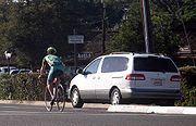
On road: bike/cycle lanes
Cycle lanes (UK) or bike lanes (USA) are lanes, for cyclists only, marked on an existing portion of a carriageway (UK) or roadway (USA).
- A cycle lane (UK) is a traffic lane marked on an existing roadway or carriageway and generally restricted to cycle traffic. It can be mandatory (marked with a solid white line, entry by motor vehicles is generally prohibited) or advisory (marked with a broken white line, entry by motor vehicles is permitted).
- In the U.S., a designated bicycle lane (1988 MUTCD) or class 2 bikeway (Caltrans) is a portion of a roadway which is separated from traffic lanes by the use of a solid white stripe on the pavement and has been designated for preferential use by bicyclists. A class 3 bicycle route has roadside signs suggesting a route for cyclists, and urging sharing the road.
On road: cycle track
A cycle track is an exclusive bike facility that has elements of a separated path and on-road bike lane. A cycle track, while still within the roadway, is physically separated from motor traffic and is distinct from the sidewalk.Cycle tracks may be one-way or two-way, and may be at road level, at sidewalk level, or at an intermediate level. They all share in common some separation from motor traffic with bollards, car parking, barriers or boulevards.
In the UK, cycle track is a roadway constructed specifically for use by cyclists, but not by any other vehicles. In Ireland cycle track also covers cycle lanes marked on the carriageway but only if accompanied by a specific sign. In the UK, a cycle track may be alongside a roadway (or carriageway) for all vehicles or it may be on its own alignment. The term does not include cycle lanes or other facilities within an all-vehicle carriageway.
Off road: shoulder
A road shoulder is a reserved area outside of a roadway, but within the road right-of-way. Road shoulders (a) are a buffer area between the roadway and possible off-road hazards intended to prevent accidents in the event of a temporary loss of vehicle control, (b) provide emergency access for ambulances and police cars and (c) provide a space for inoperable vehicles so that they do not block the traveled way. In addition, road shoulders are used by bicyclists when other bicycle-specific facilities are absent, or inferior.Off road: sidepath / shared-use footway
A sidepath in the US is a path or sidewalk that has been designated for use by cyclists within the right of way of a public road but outside of the roadway. It is usually not immediately adjacent to the portion of the way for vehicular traffic (i.e., the traveled way).A shared-use footway is for use by both cyclists and pedestrians in the UK and will usually be to a lower standard than a cycle track. While cyclists may be required to yield right of way to foot traffic on a shared use footway which is unsegregated (i.e., where both types mix freely), cyclists are usually considered to be the primary users on cycle tracks. Note that the design standards and recommendations for shared use footways and cycle tracks in the UK are different from those for shared use paths in the U.S.
Pre-motorisation
By the end of the 19th century, cycling was growing from a hobby to an established form of transport. Cyclists campaigned to improve the existing, often poorly surfaced, roads and tracks. A US group was the Good Roads MovementGood Roads Movement
The Good Roads Movement occurred in the United States between the late 1870s and the 1920s. Advocates for improved roads led by bicyclists turned local agitation into a national political movement....
. In the UK, the Cyclists' Touring Club
Cyclists' Touring Club
CTC and the UK's national cyclists' organisation are the trading names of the Cyclists' Touring Club.CTC is the United Kingdom's largest cycling membership organisation. It also has member groups in the Republic of Ireland...
(CTC) distributed a treatise entitled Roads:Their construction and maintenance. In the Netherlands the bicycle was introduced in 1870 and by the 1920s was the most popular mode of transportation (at about 75%). The first bicycle path was a 1.4 km stretch built with two paved bicycle paths alongside the Breda-Tilburg cobblestone road. Following this successful installation numerous bicycle paths separate from the roadway were constructed by "bicycle path associations" In Germany, concerns arose regarding conflicts between cyclists, horse traffic and pedestrians, leading to sections of routes being upgraded to provide smoother surfaces and separate portions for the different groups.
An early example of an American segregated cycle facility was the nine-mile dedicated Cycle-Way
California Cycleway
The California Cycleway, opened in 1900, was an elevated tollway built specially for bicycle traffic through the Arroyo Seco, intended to connect the cities of Pasadena and Los Angeles, in California, United States....
built in 1897 to connect Pasadena, California
Pasadena, California
Pasadena is a city in Los Angeles County, California, United States. Although famous for hosting the annual Rose Bowl football game and Tournament of Roses Parade, Pasadena is the home to many scientific and cultural institutions, including the California Institute of Technology , the Jet...
to Los Angeles
Los Angeles, California
Los Angeles , with a population at the 2010 United States Census of 3,792,621, is the most populous city in California, USA and the second most populous in the United States, after New York City. It has an area of , and is located in Southern California...
. Its right of way followed the stream bed of the Arroyo Seco
Arroyo Seco (Los Angeles County)
The Arroyo Seco, meaning "dry stream" in Spanish, is a seasonal river, canyon, watershed, and cultural area in Los Angeles County, California, United States. The Arroyo Seco has been called the most celebrated canyon in Southern California.-River course:...
and required 1,250,000 board feet (2,950 m3) of pine
Pine
Pines are trees in the genus Pinus ,in the family Pinaceae. They make up the monotypic subfamily Pinoideae. There are about 115 species of pine, although different authorities accept between 105 and 125 species.-Etymology:...
to construct. The roundtrip toll was 15¢ US and it was lit with electric lights along its entire length. The route did not succeed, and the right of way later became the route for the Arroyo Seco Parkway, an automobile freeway opened in 1940.
Pre World War II
With the advent of the motor car, conflict arose between the increasingly powerful car lobby and bicycle users. By the 1920s and 1930s the German car lobbies initiated efforts to have cyclists removed from the roads so as to improve the convenience of motoring. In the UK, the cycling lobby was attempting to remove motor vehicles from the roads by calling for the building of special "motor roads" to accommodate them. This idea was opposed by the Motorists' Union, who feared that it would lead to motorists' losing the freedom to use public roads.United Kingdom
In 1926 the CTCCyclists' Touring Club
CTC and the UK's national cyclists' organisation are the trading names of the Cyclists' Touring Club.CTC is the United Kingdom's largest cycling membership organisation. It also has member groups in the Republic of Ireland...
discussed an unsuccessful motion
Motion (democracy)
A motion is a formal step to introduce a matter for consideration by a group. It is a common concept in the procedure of trade unions, students' unions, corporations, and other deliberative assemblies...
calling for cycle tracks to be built on each side of roads for "the exclusive use of cyclists", and that cyclists could be taxed, providing the revenue was used for the provision of such tracks. Since the 1930s, the established cycling lobby in the UK and Ireland has taken a critical and measured view of the utility and value of segregating cyclists. In 1947, in response to official suggestions that cyclists should use cycle-tracks, the CTC adopted a motion expressing determined opposition to cycle paths alongside public roads.
The first (and one of the very few) dedicated roadside optional cycle tracks was built, as an experiment for the Ministry of Transport
Department for Transport
In the United Kingdom, the Department for Transport is the government department responsible for the English transport network and a limited number of transport matters in Scotland, Wales and Northern Ireland which are not devolved...
, beside Western Avenue between Hanger Lane
Hanger Lane
Hanger Lane is a major road in the Ealing and Park Royal areas of London. It forms the westernmost part of the A406 North Circular as it runs north from Gunnersbury Avenue as it crosses the A4020 Uxbridge Road at Ealing Common to meet the A40 Western Avenue at the Hanger Lane Gyratory System...
and Greenford
Greenford
Greenford is a large suburb in the London Borough of Ealing in west London, UK. It was historically an ancient parish in the former county of Middlesex. The most prominent landmarks in the suburb are the A40, a major dual-carriageway; Horsenden Hill, above sea level; the small Parish Church of...
Road in 1934. It was thought that "the prospect of cycling in comfort as well as safety would be appreciated by most cyclists themselves". However, the idea ran into trenchant opposition from cycling groups, with the CTC distributing pamphlets warning against the threat of cycle paths.
Local CTC branches organised mass meetings to reject the use of cycle tracks and any suggestion that cyclists should be forced to use such devices. In 1935, a packed general meeting of the CTC adopted a motion rejecting ministerial plans for cycle path construction. The CTC were listened to, and the use of cycle tracks largely fell out of favour in the UK.
Post World War II
In the UK, little use of separate cycle track systems took place except in the so-called "new towns" such as StevenageStevenage
Stevenage is a town and borough in Hertfordshire, England. It is situated to the east of junctions 7 and 8 of the A1, and is between Letchworth Garden City to the north, and Welwyn Garden City to the south....
and Harlow
Harlow
Harlow is a new town and local government district in Essex, England. It is located in the west of the county and on the border with Hertfordshire, on the Stort Valley, The town is near the M11 motorway and forms part of the London commuter belt.The district has a current population of 78,889...
. From the end of the 1960s in Nordic countries
Nordic countries
The Nordic countries make up a region in Northern Europe and the North Atlantic which consists of Denmark, Finland, Iceland, Norway and Sweden and their associated territories, the Faroe Islands, Greenland and Åland...
, the Swedish SCAFT guidelines on urban planning were highly influential and argued that non-motorised traffic must be segregated from motorised traffic wherever possible. Under the influence of these guidelines cyclists and pedestrians were treated as a homogeneous group to be catered for using similar facilities.
The guidelines strongly influenced cities such as Helsinki
Helsinki
Helsinki is the capital and largest city in Finland. It is in the region of Uusimaa, located in southern Finland, on the shore of the Gulf of Finland, an arm of the Baltic Sea. The population of the city of Helsinki is , making it by far the most populous municipality in Finland. Helsinki is...
and Västerås
Västerås
Västerås is a city in central Sweden, located on the shore of Lake Mälaren in the province Västmanland, some 100 km west of Stockholm...
to build large cycle path networks. By the late 1960s and 1970s, with the cyclists mainly gone, many German towns began removing cycle tracks so as to accommodate more car parking. Increasing traffic congestion and the 1970s oil shocks contributed to a resurgence in cycling in some countries. Outside of SCAFT-inspired developments in Nordic countries, the use of segregated cycle facilities was mainly confined to university towns with established populations of bicycle users.
1970s
In 1970 in the United Kingdom, the Milton Keynes Development CorporationMilton Keynes Development Corporation
Milton Keynes Development Corporation was established on 23 January 1967 to provide the vision and execution of a "new city", Milton Keynes, that would be the modern interpretation of the Garden city movement concepts first expressed by Ebenezer Howard 60 years earlier...
produced the "Master Plan for Milton Keynes". One of the important elements of this plan, and of its subsequent implementation, was the Milton Keynes redway system
Milton Keynes redway system
The Milton Keynes redway system is a network of cycleways/paths for cyclists and pedestrians in Milton Keynes, Buckinghamshire, England. It is generally surfaced with red tarmac, and criss-crosses most of the city....
of segregated cycle/pedestrian paths. These are fully separated from the road system, only occasionally running along side it. One of the aims of the redways was to make travel for pedestrians and cyclists convenient, safe, pleasant and accident free, but a study suggests that the system has only partially met these expectations.
More recent statistical data shows that the accident rate for pedestrians in Milton Keynes is just 46% of the average for England and the rate for cyclists is 87%. However, the secluded semi-rural nature of many redways that make them pleasant by day can make some people feel unsafe to use them after dark.
In the Netherlands bicycle use declined from the post-war period up to about 1975 as automobile use increased and commuting distances increased. Bicycle traffic policy was almost completely excluded from the national government vision. Things began to turn around in about 1972 with the oil crisis. Local and national policy began to pay more attention to cycling. Bicycle use, which had been dropping dramatically, stabilized and even rose over the next two decades. Amsterdam's traffic circulation plan of 1978 gave priority to bicycle facilities, in particular separated cycle tracks, which also meant taking some road space away from motor vehicles. The national government soon followed with subsidies for constructing bike paths alongside secondary and minor roads so that "lost ground could be made up".
In 1971 in the United States, the California state government contracted with University of California, Los Angeles
University of California, Los Angeles
The University of California, Los Angeles is a public research university located in the Westwood neighborhood of Los Angeles, California, USA. It was founded in 1919 as the "Southern Branch" of the University of California and is the second oldest of the ten campuses...
(UCLA) for the design of bikeways (bicycle paths, bicycle side-paths, bicycle lanes).
UCLA largely copied Dutch bicycle facilities practice (primarily sidepaths) to create their bikeway designs, but the derived designs were not made public. The California Statewide Bicycle Committee (CSBC) was created in 1975,
initially composed of representatives of governmental and motoring organisations. When John Forester, a cyclist representative, became a member he concluded that the real motivation for moving cyclists aside was the convenience of motorists, although the stated reason was the safety of cyclists.
When serious safety issues were identified with the proposed designs, the resulting cyclist opposition discredited the designs and prevented enactment of a mandatory side-path law. This forced the state to start over with new bikeway design standards in 1976. Those designs were subsequently adapted by the Association of American State Highway and Transportation Officials
American Association of State Highway and Transportation Officials
AASHTO, the American Association of State Highway and Transportation Officials, is a standards setting body which publishes specifications, test protocols and guidelines which are used in highway design and construction throughout the United States...
(AASHTO) to form the first edition of the AASHTO Guide for Bicycle Facilities, which is widely followed in the USA.
1980s to present
The 1980s saw the start of experimental cycle route projects in Danish towns such as Århus, OdenseOdense
The city of Odense is the third largest city in Denmark.Odense City has a population of 167,615 and is the main city of the island of Funen...
and Herning
Herning
Herning Municipality is a municipality in Region Midtjylland on the Jutland peninsula in western Denmark. The municipality covers an area of 1,336 km² and a total population of 84,208...
, and the beginning of a large programme of cycle facilities construction as part of a "bicycle masterplan" in the Netherlands. Following the "bicycle boom" of the early 1980s, German towns began revisiting the concept.
The use of segregated cycle facilities is promoted by a large segment of the cycling community, for example lane and path cyclists, and also by many organisations associated with the environmental movement
Environmental movement
The environmental movement, a term that includes the conservation and green politics, is a diverse scientific, social, and political movement for addressing environmental issues....
. The rise of the "Green" movement in the 1990s has been accompanied by requests for the construction of cycle networks in many countries. This has led to various high-profile cycle network projects, in Bogotá
Bogota's Bike Paths Network
Bogotá is the Colombian city with the most extensive and comprehensive network of bike paths. Bogotá’s bike paths network or ciclorrutas in Spanish, designed and built during the administration of Mayor Enrique Peñalosa, is also one of the most extensive in the world.The design of the network was...
, Montreal, Dublin, Portland
Portland, Oregon
Portland is a city located in the Pacific Northwest, near the confluence of the Willamette and Columbia rivers in the U.S. state of Oregon. As of the 2010 Census, it had a population of 583,776, making it the 29th most populous city in the United States...
, New York
Cycling in New York City
New York City offers a mix of favorable cycling conditions — dense urban proximities, short distances and relatively flat terrain — along with significant cycling challenges: congested roadways with stop and go traffic, a sometimes unsympathetic regulatory environment, and streets with...
, Boston, and many other cities.
Segregated facilities and safety
Safety data on segregated cycling facility is still incomplete and difficult to draw definite conclusions, though some evidence is pointing towards the lower risk of cycling-specific infrastructure. A 2006 report by the National Cooperative Highway Research Program in the UK concludes that "bicycle safety data are difficult to analyse, mostly because bicycle trip data (and thus accident probability per trip) are hard to uncover" (see NCHRP Report 552, 2006, "Guidelines for Analysis of Investment in Bicycle Facilities", National Cooperative Highway Research Program, Transportation research Board of the National Academies, page F-1). One major reason for the inability to draw definite conclusion may be that facilities with different risks are often categorized together so that off-road paths - paved or unpaved, bicycle-only or multi-use - were lumped together, as found by research at the Cycling in Cities program at the University of British Columbia.
Supporting evidence
Cycling in Cities stated in their 2009 review of the scientific literature of bicycle facilities: "It may be straightforward to count the injuries that occur on different route types (numerator data), but it is more difficult to gather data on the number of cyclists who use various route types (the denominator data needed to calculate the risk)." When they were able to look at injury and crash data separated by bicycle facility type, they found the evidence suggested that "purpose-built bicycle-only facilities have the lowest risk of crashes and injuries". They found such bike-only facilities had lower risk than cycling on-road with motor traffic as well as off-road with pedestrians on sidewalks or multi-use paths. The highest risk of crashes and injuries were found to be on sidewalks and unpaved off-road trails.The Netherlands and Denmark, which have the highest rates of cycle usage combined with the best records for safety, place importance on their segregated cycle track networks in achieving these goals. A large study undertaken into the safety of Copenhagen cycle tracks concludes that their construction resulted in an increase in cycle traffic of 18-20% and a decline in car traffic of 9-10%, contributing to an increase in cycle usage along those routes. On those same reconstructed routes accidents and injuries increased by 9-10% (the increase of accidents and injuries increased at intersections while decreased mid-block). On the surface it appears as if overall the cycle tracks actually *decrease* safety, but from the perspective of an individual cyclist, claims Dr. Lon D. Roberts, the Copenhagen shows that the "likelihood an individual bicyclist will experience an accident goes down as the number of bicycle riders go up".
The Copenhagen study also found accident and injury rates were related to the amount of car parking, turn lanes, blue cycle crossing markings, and raised exits at non-signalised intersections, suggesting that risk is dependent on making various improvements to the cycle tracks. For instance, recent planning guidelines in the US advise that cycle tracks drop to a bike lane before arriving at an intersection to increase the visibility of cyclists.
A 2010 study in Montreal, Canada, compared the motor vehicle/bicycle crashes and injuries on six Montreal cycle tracks (physically separated bicycle-exclusive paths along roads) with comparable reference roads (a parallel road with approximately the same intersection frequency and cross traffic). The authors found 2.5 times as many cyclists rode on the cycle tracks compared to the reference roads. They also found that the relative risk of injury was lower on a cycle track than on the comparable reference road (the average being 0.72 the relative risk). They concluded that "[c]ycle tracks lessen, or at least do not increase, crash and injury rates compared to bicycling in the street"
The New York City Department of Transportation implemented a bicycle path and traffic calming pilot project for Prospect Park West in Brooklyn in 2010 and published their results in early 2011. It created a 2-way bicycle path with a three foot parking lane buffer and the removal of one lane from motor vehicles. They found that weekday cycling traffic tripled after the implementation; cyclists riding on the sidewalk fell to 3% from 46% (the count included children who are legally allowed to ride on the sidewalk); speeding dropped from 74% to 20% of all vehicles; crashes for all road users were down 16% and injuries to all road users were down 21%.
Evidence against
In the 1970s the California Statewide Bicycle Committee arranged with Kenneth D. Cross for a study of car-bike collisions, expecting that this study would support their arguments on collision prevention. When presented to the Committee in SacramentoSacramento
Sacramento is the capital of the state of California, in the United States of America.Sacramento may also refer to:- United States :*Sacramento County, California*Sacramento, Kentucky*Sacramento – San Joaquin River Delta...
on 19 June 1974,
Cross's study showed the opposite: only 0.5% of car-bike collisions had occurred between straight-ahead cyclists and overtaking straight-ahead motorists. Cross later had a contract with the National Highway Traffic Safety Administration (NHTSA) to produce an improved study (on a pseudo-random national sample), and the results were much the same.
The UK Cycle Campaign Network made a 2007 statement that they know "of no evidence that cycle facilities and in particular cycle lanes, generally lead to safer conditions for cycling".
A 1994 study in Palo Alto, California found that cyclists on a sidewalk or bike path incur a greater risk of collision with a motor vehicle than on the roadway (including bike lanes on the roadway) The study, however, combined the results from sidewalks and bike paths, making it unclear what are the relative risks in the two different types of infrastructure. It's unclear from the study, as well, how Palo Alto bike paths compare to the bike paths or cycle tracks of other cities.
Other countries have had negative results from cycle tracks: In Germany, Sweden, Denmark
Denmark
Denmark is a Scandinavian country in Northern Europe. The countries of Denmark and Greenland, as well as the Faroe Islands, constitute the Kingdom of Denmark . It is the southernmost of the Nordic countries, southwest of Sweden and south of Norway, and bordered to the south by Germany. Denmark...
and Finland
Finland
Finland , officially the Republic of Finland, is a Nordic country situated in the Fennoscandian region of Northern Europe. It is bordered by Sweden in the west, Norway in the north and Russia in the east, while Estonia lies to its south across the Gulf of Finland.Around 5.4 million people reside...
, it has been found that cycling on roadside urban cycle tracks/sidepaths results in increases in the rate of car/bicycle collisions of between 1.1 and 12-fold, depending on the form of the bike lane. At a 1990 European conference on cycling, the term Russian roulette
Russian roulette
Russian roulette is a potentially lethal game of chance in which participants place a single round in a revolver, spin the cylinder, place the muzzle against their head and pull the trigger...
was used to describe the use of roadside cycle paths.
In Helsinki
Helsinki
Helsinki is the capital and largest city in Finland. It is in the region of Uusimaa, located in southern Finland, on the shore of the Gulf of Finland, an arm of the Baltic Sea. The population of the city of Helsinki is , making it by far the most populous municipality in Finland. Helsinki is...
, research has shown that cyclists are safer cycling on roads with traffic than when using the city's 800 kilometres (497.1 mi) of cycle paths. The Berlin
Berlin
Berlin is the capital city of Germany and is one of the 16 states of Germany. With a population of 3.45 million people, Berlin is Germany's largest city. It is the second most populous city proper and the seventh most populous urban area in the European Union...
police and Senate conducted studies which led to a similar conclusion in the 1980s.
Crash types
The source of the direct safety problem lies in the nature of the predominant car/bicycle collision types. The majority of collisions on urban roads occur at junctions and involve turning vehicles. Rear-end type collisions are a major factor only on arterial or interurban roads. More width for cyclists to use on rural/arterial roads with few junctions might lower the net number of collisions, but the data does not help answer the question of whether separating cyclist from other users would make a significant difference one way or the other.Crash locations
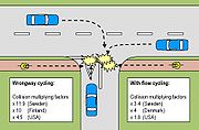
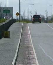
There is more risk of crashes where cycle paths meet roads. When the path entrance is set back from the road, motorists often have difficulty seeing cyclists approaching from the path. Research presented at a conference at Lund UniversityLund University
Lund University , located in the city of Lund in the province of Scania, Sweden, is one of northern Europe's most prestigious universities and one of Scandinavia's largest institutions for education and research, frequently ranked among the world's top 100 universities...
in 1990 found that "crash risk" for cycle users crossing the intersection on a set-back path are up to 11.9 times higher than when cycling on the roadway in a bike lane (see diagrams).
Segregated facilities and roundabouts
Rural and arterial roads
In the UK, cycling collision data recorded by police indicates that at non-junction locations, where a cyclist was struck directly from behind there was an overall fatality rate of 17%. The rate of fatality increases with speed limit of the road:
- 5% on 30 mph (13.4 m/s),
- 13% on 40 mph (17.9 m/s),
- 21% on 60 mph (26.8 m/s) and
- 31% on 70 mph (31.3 m/s) roads.
The use of appropriately designed segregated space on arterial or interurban routes appears to be associated with reductions in overall risk. In Ireland
Ireland
Ireland is an island to the northwest of continental Europe. It is the third-largest island in Europe and the twentieth-largest island on Earth...
, the provision of hard shoulders
Shoulder (road)
A hard shoulder, or simply shoulder, is a reserved area by the verge of a road or motorway. Generally it is kept clear of motor vehicle traffic...
on interurban routes in the 1970s reportedly resulted in a 50% decrease in accidents. It is reported that the Danes have also found that separate cycle tracks lead to a reduction in rural collisions.
Safety in Numbers effect
There is evidence that one of the main factors influencing the individual safety of cyclists is the number of cyclists using the roads, commonly called the safety in numbersSafety in numbers
Safety in numbers is the hypothesis that, by being part of a large physical group or mass, an individual is proportionally less likely to be the victim of a mishap, accident, attack, or other bad event...
effect. Cycling facilities increase the perception of safety, leaving aside the evidence supporting or detracting from their actual risk. Cycling increases on routes with cycling facilities, particularly if they are separated cycle tracks. With greater numbers of cyclists in relation to motorists the safety in number effect is seen.
A wide ranging study by P L Jacobsen found that as cycling and walking increase, the chance that a given cyclist will be struck by a motor vehicle actually decreases. This pattern is consistent across communities of varying size, from specific intersections to cities and countries, and across time periods. Jacobsen found that doubling the number of cyclists on the road tends to bring about a 1/3 drop in the per-cyclist frequency of a crash with a motor vehicle. By the same token, tripling the rate of cycling cuts the crash rate in half. A study of the accident impacts of re-engineering bicycle crossings in the Swedish city of Gothenburg
Gothenburg
Gothenburg is the second-largest city in Sweden and the fifth-largest in the Nordic countries. Situated on the west coast of Sweden, the city proper has a population of 519,399, with 549,839 in the urban area and total of 937,015 inhabitants in the metropolitan area...
appears to corroborate those findings by attributing collision rate reductions in part to significant increases in cyclist volumes at the treated sites.
Detractors argue that the most prominent examples of "successful" cycle networks were implemented in towns that already had significant numbers of cyclists. In such cases it is speculated that a existing large cycling population might already exert a "safety in numbers" effect, and it is this, rather than their diversion onto off-road tracks, that accounts for the better safety record. More people might start cycling if the perceived safety of doing so improved sufficiently.
Health Benefits
In addition it has been shown that in Western countries the health benefits of regular cycling significantly outweigh the risks due to traffic danger. Therefore, notwithstanding their effect on crashes and injuries, measures that promote cycling should produce an overall societal health benefit.Dutch analysts have argued as a statistical exercise that given that three times as many cyclists as car occupants are injured in collisions, and that cars harm about three times the number of other road users that bicycles do, in situations where casualties due to car traffic predominate increasing the number of cycling journeys and reducing the number of car journeys will reduce the total number of casualties
Remedial measures
Various remedial measures have been developed in an attempt to reduce the risk along segregated cycle facilities. In some environments these represent established engineering practice while in others they may have to be retroactively applied in response to complaints and safety concerns. Examples include the addition of a separate system of traffic signals for bicycle traffic; markings - either coloured or sharrows continued through the intersection; bike boxes with no right turn on redRight turn on red
Right turn on red, or simply right on red, is a principle of law permitting vehicles at a traffic light showing a red signal to turn right when the way is clear, in a country with right-hand traffic...
lights for motorists, raised intersections, and elimination of car parking or the barrier as the cycle track approaches the intersection.
Some treatments involve raising the cycle track onto a speed ramp type structure where it crosses side roads. In addition, various road markings have been developed in an attempt to remedy the issue of increased junction collisions. Examples of these include the use of special road markings, e.g. "sharks teeth" or "elephants footprints", and treatments using red, green or blue coloured tarmac. Other approaches include efforts to "traffic calm" the bicycle traffic by introducing tight curves or bends to slow the cyclists down as they near a junction. Alternatively, traffic engineers may remove priority from the cyclists and require them to yield to turning traffic at every side road. In 2002, engineers proposing a sidepath scheme in the Irish university city of Galway
Galway
Galway or City of Galway is a city in County Galway, Republic of Ireland. It is the sixth largest and the fastest-growing city in Ireland. It is also the third largest city within the Republic and the only city in the Province of Connacht. Located on the west coast of Ireland, it sits on the...
stated that cyclists would be required to dismount and "become pedestrian
Pedestrian
A pedestrian is a person traveling on foot, whether walking or running. In some communities, those traveling using roller skates or skateboards are also considered to be pedestrians. In modern times, the term mostly refers to someone walking on a road or footpath, but this was not the case...
s" at every junction on the finished route.
Shared Space
Segregated cycle facilities are one way to improve the perception of safety. There are other approaches, such as shared spaceShared space
Shared space is an urban design concept aimed at integrated use of public spaces. It encourages traffic engineers, urban planners and experts from other fields to consult with users of public space when planning and designing streets and squares in both built and non-built environments...
, which improve actual safety in part by decreasing the difference between real and perceived safety. More recently, shared space
Shared space
Shared space is an urban design concept aimed at integrated use of public spaces. It encourages traffic engineers, urban planners and experts from other fields to consult with users of public space when planning and designing streets and squares in both built and non-built environments...
redesigns of urban streets in Denmark, and the Netherlands have arguably achieved significant improvements in safety (as well as congestion and quality of life) by replacing segregated facilities with integrated space. Traffic reform advocates including David Engwicht and John Adams
John Adams (geographer)
Professor John Adams of University College London, is a professor of geography and leading theorist on risk compensation and an environmentalist...
suggest that the added perception of risk among all road users - motorists, cyclists and pedestrians - in shared facilities increases safety. See the Utility cycling
Utility cycling
Utility cycling encompasses any cycling not done primarily for fitness, recreation such as cycle touring, or sport such as cycle racing, but simply as a means of transport...
article for other examples of measures to improve both actual and perceived safety.
Road traffic legislation and its implications
One of the potential pitfalls for observers trying to interpret the operation of segregated cycle facilities is that the same legal assumptions do not apply in all environments. For instance, in contrast to most English speaking countries, some European countries, including Germany, France, Denmark, Belgium, and the Netherlands have defined liability legislation. Thus there is a legal assumption that motorists are automatically considered liable in law for any injuries that occur if they collide with a cyclist. This may hold regardless of any fault on the part of the cyclist and may significantly affect the behaviour of motorists when they encounter cyclists. In some countries it is legal for cyclists to overtake motor-vehicles on the inside, and cyclists doing so may enjoy the protection of the law. In this case, the use of segregated cycle facilities conforms to existing traffic law. In other jurisdictions similar "undertaking" manoeuvres by cyclists are illegal. Such distinctions form the basis of the argument that segregated cycle facilities encourage behaviours that flout existing traffic law and in which cyclists enjoy no legal protection.This variation also applies to the operation of traffic signals and cyclist-specific traffic lights. For instance, in Germany and elsewhere at junctions with segregated facilities all the traffic in a given direction (motorists, pedestrians and cyclists) may get a green signal at the same time. Turning motor traffic is obliged to wait for cyclists and pedestrians to clear the junction before proceeding. In this situation all the transport modes get equal green time. In contrast, UK and Irish practice restricts pedestrians to a dedicated signal phase, separate from and usually much shorter than the green phase for motorists (e.g. 6–12 seconds, vs. signal cycle times of up to 120 seconds). If cyclists were to be segregated and treated in a similar manner this would imply a significant reduction in green time for cycle traffic at every junction. In the English city of Cambridge
Cambridge
The city of Cambridge is a university town and the administrative centre of the county of Cambridgeshire, England. It lies in East Anglia about north of London. Cambridge is at the heart of the high-technology centre known as Silicon Fen – a play on Silicon Valley and the fens surrounding the...
the use of cyclist-specific traffic signals is reported to have resulted in increased delays for cyclists, leading some to ignore the cycle-facilities and stay on the road. A similar example occurred in a Paris
Paris
Paris is the capital and largest city in France, situated on the river Seine, in northern France, at the heart of the Île-de-France region...
ian bikepath scheme in 1999. Cyclists faced twice the number of traffic signals as motorised traffic and were expected to wait over one minute to get seven seconds of green time. Conversely, in Copenhagen cyclist-specific traffic signals on a major arterial bike lane have been linked to provide "green waves" for rush hour cycle-traffic.
Context controversy
Some detractors argue that one must be careful in interpreting the operation of segregated cycle facilities across different designs and contexts. The Netherlands, for instance, is a flat country and Dutch town planning keeps cycling distances short. The typical Dutch town bike or "granny bike" has no gears or a three-speed hub gear and back pedal brakes. In countries with different geographies and cycling cultures, people may have more bicycles with a wider range of gears and cyclists that travel more quickly, for example in North America. Sports cyclists can travel even faster: with tailwinds or downhill gradients, some cyclists may exceed 50 km/h (30 mph). While a Dutch sidepath system may work for Dutch cyclists, they might not work for cyclists using faster bicycle types who cannot use such a system safely at their higher normal cycling speeds. The Danish Roads Directorate acknowledges that the cycle track system "functions best when cyclists travel at relatively low speeds"As more cycle tracks are built in North American cities, more research is being conducted on the uptake and safety of cycle tracks. North American cities that have recently installed cycle tracks have seen significant growth in cyclists using these roads. It is useful, therefore, to use North American examples of cycle tracks/side paths and compare them to similar roads used by cyclists. This will provide better data using cyclists on similar terrain and presumably similar bicycles and experience.
Sustrans
Sustrans is a British charity to promote sustainable transport. The charity is currently working on a number of practical projects to encourage people to walk, cycle and use public transport, to give people the choice of "travelling in ways that benefit their health and the environment"...
guidelines for the National Cycle Network
National Cycle Network
The National Cycle Network is a network of cycle routes in the United Kingdom.The National Cycle Network was created by the charity Sustrans , and aided by a £42.5 million National Lottery grant. In 2005 it was used for over 230 million trips.Many routes hope to minimise contact with motor...
are based on recreational use with a design user who is an unaccompanied twelve-year-old. The Dublin Transportation Office has advertised their cycle facilities as being based on an unaccompanied ten-year-old design user. This raises the issue of what happens if different cyclist types find themselves forced onto such devices either by legal coercion or as a result of motorist aggression. This issue is captured in a 1996 review of the Sustrans approach from the Proceedings of the Institution of Civil Engineers
Institution of Civil Engineers
Founded on 2 January 1818, the Institution of Civil Engineers is an independent professional association, based in central London, representing civil engineering. Like its early membership, the majority of its current members are British engineers, but it also has members in more than 150...
.
The fast cycle commuter must not be driven off the highway onto a route that is designed for a 12-year-old or a novice on a leisure trip, because if that happens, the whole attempt to enlarge the use of the bicycle will have failed
Maintenance controversy
Some locales have issues with debris in the cycle paths, such as Milton Keynes, UK, finding that cycle path users are seven times more likely to get punctures than are road cyclists. In Ireland some cyclists have demanded simultaneous commitment to maintenance and sweeping as cycle paths are built.
In areas subject to high leaf-fall in autumn, or high snowfall in winter, any cycle facilities must be subject to regular clearing if they are to remain usable. Danish guidance specifies three different categories of cycle track. Category "A" tracks must be kept clear of snow 24 hours a day, category "B" tracks are swept or cleared daily, and category "C" receive less regular winter maintenance. In 2007 the city of Copenhagen spent DKK 9.9 million (US$1.72 million, €1.33 million) annually on maintaining its cycle track network. German federal law requires local authorities to declassify cycle tracks that do not conform to strict design and maintenance criteria. In the UK, facilities for non-motorized traffic are not normally salted or gritted in icy conditions, potentially making them dangerous or unrideable.
Usage controversy
There are many factors, such as cycle tracks and other cycling infrastructure, which contribute to cycling levels. A number of cities have demonstrated that particular cycle tracks will increase bike traffic on those routes, as shown, for example, in Montreal, New York City and Copenhagen. Bike usage increased by 40% in areas of Montreal where the city invested in bike paths and lanes. In Copenhagen bike traffic increased by about 20% because of the construction of cycle tracks. The construction of separated bike lanes on Dunsmuir Street and Viaduct in Vancouver, Canada, saw bike traffic volumes on the street more than double from before the construction. NYC likewise saw cycling rates nearly triple on weekdays and doubled on weekends when the bike path was installed alongside Prospect Park West.Seville
Seville
Seville is the artistic, historic, cultural, and financial capital of southern Spain. It is the capital of the autonomous community of Andalusia and of the province of Seville. It is situated on the plain of the River Guadalquivir, with an average elevation of above sea level...
, Spain is an example of what is possible on a city scale when a large investment is made in cycling infrastructure over a short period of time. In 2006 there were around 6000 bike trips made daily in the city of around 700,000. By 2009 there were about 50,000 daily bike trips. During those three years 8 urban bike paths totaling 70 km were built; the city centre was closed to motorised traffic; school projects were funded to create safe school paths; traffic calming measures were provided in school districts and the bicycle sharing system ‘Sevici
Sevici
Sevici is a community bicycle program in Seville inaugurated in April 2007, modeled after the Vélo'v service in Lyon and Vélib' in Paris. Its purpose is to cover the small and medium daily routes within the city in a climate friendly way, almost without pollution , roadway noise, traffic congestion...
’ was launched. The combination of all these factors helped to create a dramatic change in cycling rates.
After a certain trip modal share it may take more than just installing cycle tracks to create large increases in cycle rates. Cycling rates in the Netherlands peaked in the 1960s and dropped dramatically until the mid 1970s. The decline in bicycle use was "not only caused by mass motorization but also by the related, fairly unco-ordinated process of urbanization and by scores of social, spatial and economic developments", such as a decrease in population density and increased travel distances. The bicycle was almost completely left out of the national government's vision. Certain cities, however, such as Amsterdam and Eindhoven were slowly implementing more bicycle-positive policies: for example, bike-only streets and allowing cyclists to ignore one way streets. Throughout the 70s cycling rates increased, but the investments in bike paths made in the subsequent period had less effect. Between the late 1980s and early 1990s the Netherlands spent 1.5 billion guilders (US$945 million) on cycling infrastructure, yet cycling levels stayed practically the same.
When the flagship Delft
Delft
Delft is a city and municipality in the province of South Holland , the Netherlands. It is located between Rotterdam and The Hague....
Bicycle Route project was evaluated, the Institute for Road Safety Research claimed that the results were "not very positive: bicycle use had not increased, neither had the road safety. A route network of bicycle facilities has, apparently, no added value for bicycle use or road safety". The study by Louisse, C.J. et al. however, did find that "[a]lthough the total number of victims among cyclists did not decline, the percentage of fatalities and severely injured did drop dramatically." A more comprehensive policy change in addition to bicycle routes, on the other hand, helped to raise the cycling rates in Groningen where 75% of all traffic is by bike or foot. Groningen focused on land use policy, city planning and economic
policy changes to achieve very high cycling rates.
In the UK, a ten-year study of the effect of cycle facilities in eight towns and cities found no evidence that they had resulted in any diversion from other transport modes. The construction of 320 kilometres (198.8 mi) of "Strategic cycle network" in Dublin has been accompanied by a 15% fall in commuter cycling
Bicycle commuting
Bicycle commuting is the use of a bicycle to travel from home to a place of work or study — in contrast to the use of a bicycle for sport, recreation or touring....
and 40% falls in cycling by second and third level students.
In some locales bike traffic increases first and bike paths and lanes are installed in order to catch up to the demand. For instance, bike planning in Davis, California
Davis, California
Davis is a city in Yolo County, California, United States. It is part of the Sacramento–Arden-Arcade–Roseville Metropolitan Statistical Area...
was driven by the prior existence of a "dramatic volume" of cyclists in the 1960s. Research on the German bicycle boom of the 1980s paints a picture of German local authorities struggling to keep up with the growth of cycling rather than this growth being driven by their interventions. In relation to the UK, it has been argued that locally high levels of cycling are more likely to result from factors other than cycle facilities. These include an existing cycling culture and historically high levels of cycle use, compact urban forms, lack of hills and lack of barriers such as high speed intersections.
However, U.S.-based observers have stated that "the provision of separate cycling facilities" appears to be one of the keys to the achieving of high levels of cycling in the Netherlands, Denmark and Germany.
Segregating cyclists controversy
In some cases, cycle paths have been constructed so bicycles could be prohibited from the main roadway. There is a debate among cyclists as to whether this is for the benefit of motorists or bicyclists.In 1996 the UK Cyclists' Touring Club and the Institute of Highways and Transportation jointly produced a set of Cycle-Friendly Infrastructure guidelines that placed segregated cycling facilities at the bottom of the hierarchy of measures designed to promote cycling. Planners at the Directorate Infrastructure Traffic and Transport in Amsterdam
Amsterdam
Amsterdam is the largest city and the capital of the Netherlands. The current position of Amsterdam as capital city of the Kingdom of the Netherlands is governed by the constitution of August 24, 1815 and its successors. Amsterdam has a population of 783,364 within city limits, an urban population...
place cyclists and motorists together on roads with speed limits at or below 30 km/h (18.6 mph), and segregate them through bicycle lanes at higher limits. This is in a context where most of the measures prioritised by Cycle-Friendly Infrastructure (HGV restrictions, area-wide traffic calming, speed limit enforcement etc.) are already in place - see Utility cycling
Utility cycling
Utility cycling encompasses any cycling not done primarily for fitness, recreation such as cycle touring, or sport such as cycle racing, but simply as a means of transport...
for more detail.
Bikeways that use independent rights-of-way
Bike paths that follow independent rights-of-way are less controversial. Such paths are often used to promote recreational cycling. In Northern European countries, cycling tourism represents a significant proportion of overall tourist activity. Extensive interurban bike path networks can be found in countries such as Denmark, which has had a national system of cycle routes since 1993. These networks may use routes dedicated exclusively to cycle traffic or minor rural roads whose use is otherwise restricted to local motor traffic and agricultural machinery. The UK has recently implemented the National Cycle NetworkNational Cycle Network
The National Cycle Network is a network of cycle routes in the United Kingdom.The National Cycle Network was created by the charity Sustrans , and aided by a £42.5 million National Lottery grant. In 2005 it was used for over 230 million trips.Many routes hope to minimise contact with motor...
.
Where available these routes often make use of abandoned railway corridors - see picture right of Mosel Maar cycle route. A prominent example in the UK is the Bristol & Bath Railway Path, a 13 miles (20.9 km) bike path that is part of National Cycle Route 4
NCR 4
Between London and Fishguard, the route runs through Reading, Bath, Bristol, Newport, Swansea, Llanelli and St David's. Within Wales, NCR 4 forms one of the branches of the Celtic Trail cycle route.-London to Reading:Chertsey | Staines | Eton | Maidenhead...
. Other UK examples include The Ebury Way Cycle Path
The Ebury Way Cycle Path
The Ebury Way Cycle Path is a rail trail running between Rickmansworth and Watford in Hertfordshire, England.The path, through lakes and fields in Rickmansworth, is shared with walkers and cyclists. Its origin as the Watford and Rickmansworth Railway endowes it with generous width and gentle...
, The Alban Way, the Hillend Loch Railway Path
Hillend Loch Railway Path
The Hillend Loch Railway Path is a rail trail located in central Scotland. The path is approximately long and follows the route of the former Bathgate and Coatbridge Railway between Airdrie, North Lanarkshire and Bathgate, West Lothian...
and the Nicky Line
Nicky Line
The Nicky Line is the local nickname for the railway that once linked the English towns of Hemel Hempstead and Harpenden via Redbourn. It was officially known as the Harpenden and Hemel Hempstead Railway...
. In 2003 the longest continuous bike path in Europe was opened, along the Albacete
Albacete
Albacete is a city and municipality in southeastern Spain, 258 km southeast of Madrid, the capital of the province of Albacete in the autonomous community of Castile-La Mancha. The municipality had a population of c. 169,700 in 2009....
-Valdeganga
Valdeganga
Valdeganga is a municipality in Albacete, Castile-La Mancha, Spain. It has a population of 1,936....
highway in Spain, a distance of 22 kilometres (13.7 mi). Bogota's Bike Paths Network
Bogota's Bike Paths Network
Bogotá is the Colombian city with the most extensive and comprehensive network of bike paths. Bogotá’s bike paths network or ciclorrutas in Spanish, designed and built during the administration of Mayor Enrique Peñalosa, is also one of the most extensive in the world.The design of the network was...
or "Ciclo-Ruta" in Spanish, designed and built during the administration of Mayor Enrique Peñalosa attracts significant recreational use.
The relative safety of bike paths that follow independent rights-of-way closed to motorized traffic is difficult to assess. In terms of car/bicycle collisions, this is clearly mediated by how the bike path network rejoins the main road network. In the English town of Milton Keynes, a study showed that cyclists using the off-road Milton Keynes redway system
Milton Keynes redway system
The Milton Keynes redway system is a network of cycleways/paths for cyclists and pedestrians in Milton Keynes, Buckinghamshire, England. It is generally surfaced with red tarmac, and criss-crosses most of the city....
had on a per-journey basis a significantly higher rate of fatal car-bicycle collisions at path/roadway crossings than cyclists on ordinary roads.
The consequences of other risks — falls, cyclist–cyclist collisions and cyclist–pedestrian collisions — are frequently not recorded in official accident figures and may be available only via local hospital surveys. As a general rule those bike paths with the highest perceived safety tend to be those engineered on the assumption of vehicular rather than pedestrian traffic. Thus the most popular examples tend to be converted road or railway alignments or constructed to the same standards used by road and railway engineers.
Other bikeways
Other types of bikeway infrastructure are also in use by cities. They are often used for different reasons: the locale may have a different planning philosophy; the street may be too narrow for bike lanes or cycle tracks; the location may be inappropriate; or for political reasons it may be easier to install something other than a fully segregated cycle facility. They include:- Shared spaceShared spaceShared space is an urban design concept aimed at integrated use of public spaces. It encourages traffic engineers, urban planners and experts from other fields to consult with users of public space when planning and designing streets and squares in both built and non-built environments...
- Urban design concept that removes traditional segregation among motor vehicles, pedestrians and cyclists and replaces with more "people-oriented" infrastructure. - SharrowsShared lane markingA shared-lane marking or sharrow is a street marking installed at locations in Australia, Canada, and the United States. This marking is placed in the center of a travel lane to indicate that a bicyclist may use the full lane...
- Usually a bike symbol with chevrons painted in a regular lane to demarcate where cyclists should ride. - Bicycle boulevardBicycle boulevardA bicycle boulevard is a low speed street which has been optimized for bicycle traffic. Bicycle boulevards discourage cut-through motor vehicle traffic but allow local motor vehicle traffic. They are designed to give priority to cyclists as through-going traffic...
- a low speed street that has been optimized for bicycle traffic.
See also
- List of cycleways
- Bogotá's Bike Paths NetworkBogota's Bike Paths NetworkBogotá is the Colombian city with the most extensive and comprehensive network of bike paths. Bogotá’s bike paths network or ciclorrutas in Spanish, designed and built during the administration of Mayor Enrique Peñalosa, is also one of the most extensive in the world.The design of the network was...
- Cycling in CopenhagenCycling in CopenhagenCycling in Copenhagen is - as with most bicycling in Denmark - an important means of transportation and a dominating feature of the cityscape, often noticed by visitors. The city offers a variety of favorable cycling conditions — dense urban proximities, short distances and flat terrain...
- Door zoneDoor zoneThe door zone is the space spanning about four feet from the sides of parallel parked cars. It is hazardous to ride a bicycle or motorcycle in a door zone because if a door is suddenly opened, the cyclist must either crash into it , brake suddenly, or swerve into the adjacent lane of traffic...
- Effective CyclingEffective CyclingEffective Cycling is a trademarked cycling educational program designed by John Forester, which was the national education program of the League of American Wheelmen for a number of years until Forester withdrew permission for them to use the name...
- Rail trailRail trailA rail trail is the conversion of a disused railway easement into a multi-use path, typically for walking, cycling and sometimes horse riding. The characteristics of former tracks—flat, long, frequently running through historical areas—are appealing for various development. The term sometimes also...
- Utility cyclingUtility cyclingUtility cycling encompasses any cycling not done primarily for fitness, recreation such as cycle touring, or sport such as cycle racing, but simply as a means of transport...
- Vehicular cyclingVehicular cyclingVehicular cycling is the practice of riding bicycles on roads in a manner that is visible, predictable, and in accordance with the principles for driving in traffic.The phrase vehicular cycling was coined by John Forester in the 1970s to characterize the...
- Motorcycle laneMotorcycle laneMotorcycle lane is a main term for special lane for small vehicles such as motorcycles, scooters, bicycles, trishaw and many more.- Malaysia :...
- similar facilities intended for motorcycle segregation from other vehicles. - EuroVeloEuroVelo]EuroVelo, the European cycle route network, is a project of the European Cyclists' Federation to develop 13 long-distance cycle routes crossing Europe. The total length is , of which more than are in place....
- European cycle route network
Historical
- History of Dutch Cycle paths - first bike path built in 1885 in Utrecht
- California's Great Cycle-Way - printed in Good Roads Magazine, 1901
- Video of the first cycle track in the UK - British Pathe
- Cycle Path Safety: A Summary of Research - John Franklin
- A history of cycle paths in Europe and USA - John Franklin
- History of cycle tracks in Germany - up until 1940
- History of cycling in the UK - Howard Peel
- National Socialist traffic planning - segregated bike traffic in 1930s Germany
Contemporary
- NACTO Urban Bikeway Design Guide
- PRESTO - Promoting Cycling for Everyone as a Daily Transport Mode” is a project of the EU’s Intelligent Energy – Europe Programme granted by the Executive Agency for Competitiveness and Innovation (EACI).]
- Collection of Cycle Concepts, Danish Roads Directorate, 2000.
- Bikeway Planning and Design, Chapter 1000, Caltrans Highway Design Manual, California USA, February 2001.
- The impact of transportation infrastructure on bicycling injuries & crashes: a review of the evidence
- Pedestrian and Bicyclist Safety and Mobility in Europe by US Department of Transportation
- Bicycle sidepath hazards - at a university campus
- Critiques of bikeways The Vehicular Cyclist
- Facility of the Month by the Warrington Cycle CampaignWarrington Cycle CampaignWarrington Cycle Campaign is a cycling campaign group that aims to promote safer cycling and more cycling.Although based in Warrington in England, the Campaign has received international recognition, mainly due to its Cycle facility of the month feature....
- Road safety and perceived risk of cycle tracks and lanes in Copenhagen
- Shared Space - a UK TV news piece about an urban alternative to segregated cycling facilities
- Vassar Street critique - a detailed look at a sidepath design in Cambridge, MassachusettsCambridge, MassachusettsCambridge is a city in Middlesex County, Massachusetts, United States, in the Greater Boston area. It was named in honor of the University of Cambridge in England, an important center of the Puritan theology embraced by the town's founders. Cambridge is home to two of the world's most prominent...
- Weird cycle lanes of Brighton - short and strange cycle lanes in BrightonBrightonBrighton is the major part of the city of Brighton and Hove in East Sussex, England on the south coast of Great Britain...
- Mexico City Ciclopista
- Livable Communities Resource Guide
- Cycle path safety: A summary of research
- Opencyclemap