
River Nith
Encyclopedia
- For the river in southwestern Ontario, see Nith RiverNith RiverThe Nith River is a river in Brant, Oxford and Perth Counties and the Regional Municipality of Waterloo in Southwestern Ontario, Canada. The Nith River empties into the Grand River at the town of Paris, and is named after the River Nith in Scotland....
.
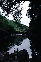
The River Nith is a river in South West Scotland.
Source, flow and mouth
The Nith rises in the Carsphairn hillsCarsphairn and Scaur Hills
The Carsphairn and Scaur hills are the western and eastern hills respectively of a hill range in the Southern Uplands of Scotland. Ordnance Survey maps don't have a general name for the hill area as a whole. Also, Ordnance Survey use "Scar" rather than the local spelling of "Scaur" - the word is...
of East Ayrshire
East Ayrshire
East Ayrshire is one of 32 council areas of Scotland. It borders on to North Ayrshire, East Renfrewshire, South Lanarkshire, South Ayrshire and Dumfries and Galloway...
, more precisely between Prickeny Hill and Enoch Hill, 7 km East of Dalmellington
Dalmellington
Dalmellington is a market town in Ayrshire, Scotland. In 2001 it had a population of 1407. The town owes its origins to the fault line separating the Southern Uplands of Scotland from the Central Lowlands...
. For the majority of its course it flows in a generally Southern direction through Dumfries and Galloway
Dumfries and Galloway
Dumfries and Galloway is one of 32 unitary council areas of Scotland. It was one of the nine administrative 'regions' of mainland Scotland created in 1975 by the Local Government etc. Act 1973...
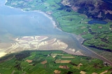
, before spilling into the Solway Firth
Solway Firth
The Solway Firth is a firth that forms part of the border between England and Scotland, between Cumbria and Dumfries and Galloway. It stretches from St Bees Head, just south of Whitehaven in Cumbria, to the Mull of Galloway, on the western end of Dumfries and Galloway. The Isle of Man is also very...
at Ards point.
The territory through which the river flows is called Nithsdale
Nithsdale
Nithsdale , also known by its anglicised gaelic name Strathnith or Stranit, is the valley of the River Nith in Scotland, and the name of the region...
(historically known as "Stranit" from , "valley of the Nith").
Length
For estuaries the principle followed is that the river should be visible at all times. The measurement therefore follows the centre of the river at low tide and the mouth of the river is assumed to be at the coastal high tide mark. In Scotland this does not generally make a significant difference, except for rivers draining into shallow sloping sands of the Irish Sea and Solway Firth, notably the Nith. At low tide, the sea recedes to such an extent that the length of the Nith is extended by 13km to 113.8km (70.7 miles), making it Scotland's seventh longest river.Tributaries
Upstream to Downstream:- Connel BurnConnel BurnConnel Burn is a river in East Ayrshire, Scotland which rises at Enoch Hill in the Southern Uplands and flows northwards through Laglaf and Connel Park before meeting the River Nith in New Cumnock.-References:...
- Afton Water
- Kello Water
- Crawick Water
- Euchan Water
- Mennock Water
- Carron WaterCarron Water, DumfriesshireThe Carron Water is a tributary of the River Nith in southwest Scotland. It rises in the Dalveen Pass in the Lowther Hills as its headwater streams, the Dinabid Linn, Dalveen Lane and Lavern Burn join to flow southwards, to the west of the village of Durisdeer, to meet the Nith at Carronbridge....
- Cample Water
- Scar Water
- Shinnel WaterShinnel WaterShinnel Water, also spelt Shinnell, is a river in the region of Dumfries and Galloway, Scotland.It rises in the Scaur hills hills of Tynron Parish in the Southern Uplands at an altitude of 460m, and flows 13 miles to join Scaur Water near Penpont, at an altitude of 70m...
- Cluden Water
- Cargen Pow
- New Abbey Pow
Settlements

- Carron Bridge
- New CumnockNew CumnockNew Cumnock is a place in East Ayrshire, Scotland. It expanded during the coal mining era but, like so many others, suffered after the deep shaft pits closed in the 1980's...
- KirkconnelKirkconnelKirkconnel is a small parish and town in Dumfries and Galloway, southwestern Scotland. It is located on the A76 near the head of Nithsdale. Kirkconnel led a more quiet existence than neighboring towns like Sanquhar. Principally it has been a farming community. There are few buildings of any...
- SanquharSanquharSanquhar is a town on the River Nith in Dumfries and Galloway, Scotland. It lies north of Thornhill and west of Moffat. It is a Royal Burgh.Sanquhar is notable for its tiny post office , claimed to be the oldest working post office in the world...
- Mennock
- ThornhillThornhill, Dumfries and GallowayThornhill is a town in the Mid Nithsdale area of Dumfries and Galloway, Scotland, south of Sanquhar and north of Dumfries.A monument to the explorer Joseph Thomson , who lived in neighbouring Penpont and Gatelawbridge, can be found close to the school...
- DumfriesDumfriesDumfries is a market town and former royal burgh within the Dumfries and Galloway council area of Scotland. It is near the mouth of the River Nith into the Solway Firth. Dumfries was the county town of the former county of Dumfriesshire. Dumfries is nicknamed Queen of the South...
- GlencapleGlencapleGlencaple is a small settlement in the Dumfries and Galloway area of Scotland. Situated on the banks of the River Nith, it once served as a port for nearby Dumfries. Dumfries F.C. play their home matches at Norfolk Park in Glencaple....