
Merrick, Galloway
Encyclopedia
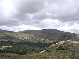
Merrick is the highest mountain
in the Southern Uplands
of southern Scotland
and is part of the Range of the Awful Hand
.
The shortest route of ascent is from the car park in Glen Trool
. The car park is located near Bruces Stane, a monument commemorating the victory of Robert the Bruce
over the English forces of Edward II
at the Battle of Glen Trool
in 1307.
An interesting feature on the mountain is the presence of several large partly buried granite
boulders at about 800m on the broad west ridge. These are glacial erratic
s, though the exact mechanism that has brought them to rest close to the highest point of the Southern Uplands
and over 200m higher than any currently occurring granite in the Galloway Hills
is unclear.
then up on to Benyellary
. After dropping slightly the final climb to the summit trig-point is made. Be aware that if descending in poor visibility a very common mistake is to walk down the west ridge into remote terrain. The total round-trip distance from Glen Trool to the summit and back is just under 8 miles.
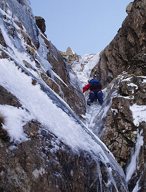
has been recorded on the Merrick. However, in winter after a good freeze there are a number of good ice climbs
of up to 200 m on the Black Gairy, which lies west of the summit.
Mountain
Image:Himalaya_annotated.jpg|thumb|right|The Himalayan mountain range with Mount Everestrect 58 14 160 49 Chomo Lonzorect 200 28 335 52 Makalurect 378 24 566 45 Mount Everestrect 188 581 920 656 Tibetan Plateaurect 250 406 340 427 Rong River...
in the Southern Uplands
Southern Uplands
The Southern Uplands are the southernmost and least populous of mainland Scotland's three major geographic areas . The term is used both to describe the geographical region and to collectively denote the various ranges of hills within this region...
of southern Scotland
Scotland
Scotland is a country that is part of the United Kingdom. Occupying the northern third of the island of Great Britain, it shares a border with England to the south and is bounded by the North Sea to the east, the Atlantic Ocean to the north and west, and the North Channel and Irish Sea to the...
and is part of the Range of the Awful Hand
Range of the Awful Hand
The Range of the Awful Hand is a range of hills in the Southern Uplands of Scotland named due to their resemblance to the fingers of a hand. The hills, starting at the 'thumb' are:*Benyellary *Merrick *Kirriereoch Hill...
.
The shortest route of ascent is from the car park in Glen Trool
Glen Trool
Glen Trool is a glen in the Southern Uplands, Galloway, Scotland. It contains Loch Trool which is fed by several burns and drained by the Water of Trool. North of Glen Trool is Merrick, the highest mountain in the Southern Uplands. The glen has a visitors centre and campsite.In April 1307 it was...
. The car park is located near Bruces Stane, a monument commemorating the victory of Robert the Bruce
Robert I of Scotland
Robert I , popularly known as Robert the Bruce , was King of Scots from March 25, 1306, until his death in 1329.His paternal ancestors were of Scoto-Norman heritage , and...
over the English forces of Edward II
Edward II of England
Edward II , called Edward of Caernarfon, was King of England from 1307 until he was deposed by his wife Isabella in January 1327. He was the sixth Plantagenet king, in a line that began with the reign of Henry II...
at the Battle of Glen Trool
Battle of Glen Trool
The Battle of Glen Trool was a minor engagement in the Scottish Wars of Independence, fought in April 1307. Glen Trool is a narrow glen in the Southern Uplands of Galloway, Scotland...
in 1307.
An interesting feature on the mountain is the presence of several large partly buried granite
Granite
Granite is a common and widely occurring type of intrusive, felsic, igneous rock. Granite usually has a medium- to coarse-grained texture. Occasionally some individual crystals are larger than the groundmass, in which case the texture is known as porphyritic. A granitic rock with a porphyritic...
boulders at about 800m on the broad west ridge. These are glacial erratic
Glacial erratic
A glacial erratic is a piece of rock that differs from the size and type of rock native to the area in which it rests. "Erratics" take their name from the Latin word errare, and are carried by glacial ice, often over distances of hundreds of kilometres...
s, though the exact mechanism that has brought them to rest close to the highest point of the Southern Uplands
Southern Uplands
The Southern Uplands are the southernmost and least populous of mainland Scotland's three major geographic areas . The term is used both to describe the geographical region and to collectively denote the various ranges of hills within this region...
and over 200m higher than any currently occurring granite in the Galloway Hills
Galloway Hills
The Galloway hills are part of the Southern Uplands of Scotland, and form the northern boundary of western Galloway. They lie within the bounds of Galloway Forest Park, an area of some of largely uninhabited wild land, managed by the Forestry Commission...
is unclear.
Walking
The Merrick is a relatively straightforward and easy hill walk from the car park near Bruces Stane. The route climbs past the ruined Culsharg bothyBothy
A bothy is a basic shelter, usually left unlocked and available for anyone to use free of charge. It was also a term for basic accommodation, usually for gardeners or other workers on an estate. Bothies are to be found in remote, mountainous areas of Scotland, northern England, Ireland, and Wales....
then up on to Benyellary
Benyellary
Benyellary is one of the Galloway Hills, in the Range of the Awful Hand. Its peak is at an elevation of above sea level....
. After dropping slightly the final climb to the summit trig-point is made. Be aware that if descending in poor visibility a very common mistake is to walk down the west ridge into remote terrain. The total round-trip distance from Glen Trool to the summit and back is just under 8 miles.
Climbing
Because of the nature of the rock no good rock climbingRock climbing
Rock climbing also lightly called 'The Gravity Game', is a sport in which participants climb up, down or across natural rock formations or artificial rock walls. The goal is to reach the summit of a formation or the endpoint of a pre-defined route without falling...
has been recorded on the Merrick. However, in winter after a good freeze there are a number of good ice climbs
Ice climbing
Ice climbing, as the term indicates, is the activity of ascending inclined ice formations. Usually, ice climbing refers to roped and protected climbing of features such as icefalls, frozen waterfalls, and cliffs and rock slabs covered with ice refrozen from flows of water. For the purposes of...
of up to 200 m on the Black Gairy, which lies west of the summit.
External links
- Link to computer-generated virtual panoramas from Merrick North South. The 144 mile view between Merrick and SnowdonSnowdonSnowdon is the highest mountain in Wales, at an altitude of above sea level, and the highest point in the British Isles outside Scotland. It is located in Snowdonia National Park in Gwynedd, and has been described as "probably the busiest mountain in Britain"...
is the longest line of sight in the British Isles http://www.viewfinderpanoramas.org/panoramas.html#longlinesbrit, but for geometrical reasons Merrick would be very difficult to observe from Snowdon. - Link to panoramic image taken from the summit of the Merrick