
The Cheviot
Encyclopedia
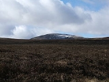
The Cheviot is the highest summit
in the Cheviot Hills
in the far north of England
, only 2 km from the Scottish
border. It is the last major peak on the Pennine Way
, if travelling from south to north, before the descent into Kirk Yetholm
.
Other than the route via the Pennine Way, most routes up The Cheviot start from the Harthope Burn side to the northeast, which provides the nearest access by road. The summit is around 5 km from the road-end at Langleeford. There are routes following the ridges above either side of the valley, and a route that sticks to the valley floor until it climbs to the summit of The Cheviot from the head of the valley.
Although the Pennine Way itself does a two-mile out-and-back detour to the Cheviot, many walkers who come this way omit it, since the stage (the last) is 29 miles long.
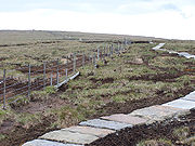 The summit of the Cheviot is very flat. It is an ancient, extinct volcano. It is covered with an extensive peat bog up to 2 m deep; the Northumberland National Park
authority have laid down stone slabs on the main access footpath to prevent erosion damage to the peat and to make access to the summit safer for walkers.
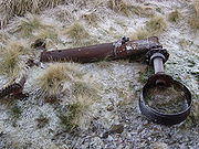
North of the summit, in the peat bogs, are the remains of a crashed B-17 bomber, which hit the mountain due to a navigational error in World War II
. The more recognisable pieces of wreckage have been removed, but pieces of the aircraft can still be found.
 The view is obscured greatly by the flatness of the summit plateau. Nevertheless, on a clear day the following are visible (from west, clockwise); Broad Law
, Moorfoot Hills
, Pentland Hills
, the Ochils, Lammermuir Hills
, Lochnagar
, Ros Hill
, Long Crag
, Urra Moor
, Tosson Hill
, Burnhope Seat
, Cross Fell
, Helvellyn
, Scafell Pike
, Skiddaw
, Sighty Crag
, Peel Fell
, Queensberry
.
Summit (topography)
In topography, a summit is a point on a surface that is higher in elevation than all points immediately adjacent to it. Mathematically, a summit is a local maximum in elevation...
in the Cheviot Hills
Cheviot Hills
The Cheviot Hills is a range of rolling hills straddling the England–Scotland border between Northumberland and the Scottish Borders.There is a broad split between the northern and the southern Cheviots...
in the far north of England
England
England is a country that is part of the United Kingdom. It shares land borders with Scotland to the north and Wales to the west; the Irish Sea is to the north west, the Celtic Sea to the south west, with the North Sea to the east and the English Channel to the south separating it from continental...
, only 2 km from the Scottish
Scotland
Scotland is a country that is part of the United Kingdom. Occupying the northern third of the island of Great Britain, it shares a border with England to the south and is bounded by the North Sea to the east, the Atlantic Ocean to the north and west, and the North Channel and Irish Sea to the...
border. It is the last major peak on the Pennine Way
Pennine Way
The Pennine Way is a National Trail in England. The trail runs from Edale, in the northern Derbyshire Peak District, north through the Yorkshire Dales and the Northumberland National Park and ends at Kirk Yetholm, just inside the Scottish border. The path runs along the Pennine hills, sometimes...
, if travelling from south to north, before the descent into Kirk Yetholm
Kirk Yetholm
Kirk Yetholm is a village in the Scottish Borders region of Scotland, south east of Kelso and less than west of the border. The first mention is of its church in the 13th century. Its sister town is Town Yetholm which lies half a mile across the Bowmont Water...
.
Other than the route via the Pennine Way, most routes up The Cheviot start from the Harthope Burn side to the northeast, which provides the nearest access by road. The summit is around 5 km from the road-end at Langleeford. There are routes following the ridges above either side of the valley, and a route that sticks to the valley floor until it climbs to the summit of The Cheviot from the head of the valley.
Although the Pennine Way itself does a two-mile out-and-back detour to the Cheviot, many walkers who come this way omit it, since the stage (the last) is 29 miles long.
Northumberland National Park
Northumberland National Park is the northernmost national park in England. It covers an area of more than 1030 km² between the Scottish Border in the north to just south of Hadrian's Wall. It is one of the least populated and least visited of the National Parks...
authority have laid down stone slabs on the main access footpath to prevent erosion damage to the peat and to make access to the summit safer for walkers.
North of the summit, in the peat bogs, are the remains of a crashed B-17 bomber, which hit the mountain due to a navigational error in World War II
World War II
World War II, or the Second World War , was a global conflict lasting from 1939 to 1945, involving most of the world's nations—including all of the great powers—eventually forming two opposing military alliances: the Allies and the Axis...
. The more recognisable pieces of wreckage have been removed, but pieces of the aircraft can still be found.
View
Broad Law
Broad Law is the second highest hill in the wide expanse of hill country in Southern Scotland, the Southern Uplands, and the highest for 30 miles in all directions. It is only ten feet lower than its parent, Merrick...
, Moorfoot Hills
Moorfoot Hills
The Moorfoot Hills are a range of hills south of Edinburgh in east central Scotland, UK, one of the ranges which collectively form the Southern Uplands.The Hills run from Peebles, Scottish Borders, in a north easterly direction to Tynehead, Midlothian....
, Pentland Hills
Pentland Hills
The Pentland Hills are a range of hills to the south-west of Edinburgh, Scotland. The range is around 20 miles in length, and runs south west from Edinburgh towards Biggar and the upper Clydesdale.Some of the peaks include:* Scald Law...
, the Ochils, Lammermuir Hills
Lammermuir Hills
The Lammermuir Hills, usually simply called the Lammermuirs , in southern Scotland, form a natural boundary between Lothian and the Scottish Borders....
, Lochnagar
Lochnagar
Lochnagar or Beinn Chìochan is a mountain in the Grampians of Scotland, located about five miles south of the River Dee near Balmoral.-Names:...
, Ros Hill
Ros Hill
Ros Hill, also known as Ros Castle due to the 3,000-year-old Iron Age hill fort on its summit, is a hill in the county of Northumberland in northern England. It is the highest point of a low range of hills stretching from Alnwick to Berwick-upon-Tweed - the Chillingham Hills. Other tops of the...
, Long Crag
Long Crag
Long Crag is a hill to the north of Rothbury in Northumberland, England. It lies within the Thrunton Woods, a Forestry Commission-owned area of forestry plantations....
, Urra Moor
Urra Moor
Urra Moor is the highest moor in the North York Moors at 454 metres above sea level, in the national park in North Yorkshire, England. The name applies to the moor as a whole; the summit itself is known as Round Hill....
, Tosson Hill
Tosson Hill
Tosson Hill is the highest hill in the Simonside Hills to the south of Rothbury in Northumberland, England. The summit lies about west of Simonside, the best known summit of the Simonside Hills....
, Burnhope Seat
Burnhope Seat
Burnhope Seat is a moor in the North Pennines of England. It lies between the heads of the Rivers Tees, South Tyne and Wear. The summit is crossed by the boundary between County Durham and Cumbria...
, Cross Fell
Cross Fell
Cross Fell is the highest point in the Pennine Hills of northern England and the highest point in England outside of the Lake District.The summit, at , is a stony plateau, part of a long ridge running North West to South East, which also incorporates Little Dun Fell at and Great Dun Fell at...
, Helvellyn
Helvellyn
Helvellyn is a mountain in the English Lake District, the apex of the Eastern Fells. At above sea level, it is the third highest peak in both the Lake District and England...
, Scafell Pike
Scafell Pike
Scafell Pike is the highest mountain in England at . It is located in Lake District National Park sometimes confused with the neighbouring Sca Fell, to which it is connected by the col of Mickledore...
, Skiddaw
Skiddaw
Skiddaw is a mountain in the Lake District National Park in England. With a summit at 931 m above sea level it is the fourth highest mountain in England. It lies just north of the town of Keswick, Cumbria, and dominates the skyline in this part of the northern lakes...
, Sighty Crag
Sighty Crag
Sighty Crag is a hill in the southern part of the Kielder Forest region in northern England, a region which also includes its fellow Marilyns of Peel Fell and Larriston Fells...
, Peel Fell
Peel Fell
Peel Fell is the highest hill in the Kielder Forest region of England, making it the highest hill for several miles in each direction until the Cheviot Hills to the north-east are reached. Because of this, it has enough relative height to make it a Marilyn...
, Queensberry
Queensberry (hill)
Queensberry is a hill at the southern end of the Lowther Hills in southern Scotland....
.
External links
- Computer generated summit panorama The Cheviot