
Wigtownshire
Encyclopedia
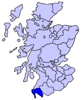
Wigtownshire or the County of Wigtown is a registration county
in the Southern Uplands
of south west Scotland
. Until 1975, the county was one of the administrative counties
used for local government purposes, and is now administered as part of the council area of Dumfries and Galloway
. The county town
was historically Wigtown
, with the administrative centre
moving to Stranraer
- the largest town - on the creation of a county council in 1890. As Wigtown, the county forms the lieutenancy area
of the Lord Lieutenant of Wigtown
.
Wigtownshire borders Ayrshire
to the north, and the Stewartry of Kirkcudbright to the east. Together The Stewartry and Wigtownshire are referred to as Galloway
: until the 19th century Wigtownshire was also sometimes known as West Galloway.
, the Machars
and the Rhins of Galloway
peninsula. Major road links to the area comprise the A77
to the north, and the A75
to the east.
Registration county
A registration county was, in Great Britain and Ireland, a statistical unit used for the registration of births, deaths and marriages and for the output of census information. In Scotland registration counties are used for land registration purposes....
in the Southern Uplands
Southern Uplands
The Southern Uplands are the southernmost and least populous of mainland Scotland's three major geographic areas . The term is used both to describe the geographical region and to collectively denote the various ranges of hills within this region...
of south west Scotland
Scotland
Scotland is a country that is part of the United Kingdom. Occupying the northern third of the island of Great Britain, it shares a border with England to the south and is bounded by the North Sea to the east, the Atlantic Ocean to the north and west, and the North Channel and Irish Sea to the...
. Until 1975, the county was one of the administrative counties
Counties of Scotland
The counties of Scotland were the principal local government divisions of Scotland until 1975. Scotland's current lieutenancy areas and registration counties are largely based on them. They are often referred to as historic counties....
used for local government purposes, and is now administered as part of the council area of Dumfries and Galloway
Dumfries and Galloway
Dumfries and Galloway is one of 32 unitary council areas of Scotland. It was one of the nine administrative 'regions' of mainland Scotland created in 1975 by the Local Government etc. Act 1973...
. The county town
County town
A county town is a county's administrative centre in the United Kingdom or Ireland. County towns are usually the location of administrative or judicial functions, or established over time as the de facto main town of a county. The concept of a county town eventually became detached from its...
was historically Wigtown
Wigtown
Wigtown is a town and former royal burgh in the Machars of Galloway in the south west of Scotland. It lies south of Newton Stewart and east of Stranraer. It has a population of about 1,000...
, with the administrative centre
Administrative centre
An administrative centre is a term often used in several countries to refer to a county town, or other seat of regional or local government, or the place where the central administration of a commune is located....
moving to Stranraer
Stranraer
Stranraer is a town in the southwest of Scotland. It lies in the west of Dumfries and Galloway and in the county of Wigtownshire.Stranraer lies on the shores of Loch Ryan on the northern side of the isthmus joining the Rhins of Galloway to the mainland...
- the largest town - on the creation of a county council in 1890. As Wigtown, the county forms the lieutenancy area
Lieutenancy areas of Scotland
The lieutenancy areas of Scotland are the areas used for the ceremonial lord-lieutenants, the monarch's representatives, in Scotland. They are different from the local government council areas, the committee areas, the sheriffdoms, the registration counties, the former regions and districts, the...
of the Lord Lieutenant of Wigtown
Lord Lieutenant of Wigtown
This is a list of people who have served as Lord Lieutenant of Wigtownshire, a county in the Dumfries and Galloway council area of south-west Scotland.-Title:...
.
Wigtownshire borders Ayrshire
Ayrshire
Ayrshire is a registration county, and former administrative county in south-west Scotland, United Kingdom, located on the shores of the Firth of Clyde. Its principal towns include Ayr, Kilmarnock and Irvine. The town of Troon on the coast has hosted the British Open Golf Championship twice in the...
to the north, and the Stewartry of Kirkcudbright to the east. Together The Stewartry and Wigtownshire are referred to as Galloway
Galloway
Galloway is an area in southwestern Scotland. It usually refers to the former counties of Wigtownshire and Kirkcudbrightshire...
: until the 19th century Wigtownshire was also sometimes known as West Galloway.
Geography
Wigtownshire includes the southernmost point in Scotland, the Mull of GallowayMull of Galloway
The Mull of Galloway is the southernmost point of Scotland. It is situated in Wigtownshire, Dumfries and Galloway.A lighthouse is positioned at the point . Built in 1830 by engineer Robert Stevenson, the white-painted round tower is high...
, the Machars
Machars
The Machars is a peninsula in Galloway in the south-west of Scotland. The word is derived from the Gaelic word Machair meaning low lying or level land, known as "links" on the east coast of Scotland...
and the Rhins of Galloway
Rhins of Galloway
The Rhins of Galloway is a hammer-head peninsula in Dumfries and Galloway, Scotland...
peninsula. Major road links to the area comprise the A77
A77 road
The A77 road is a major road in Scotland. It runs in a southwesternly direction from the city of Glasgow, past the towns of Giffnock, Newton Mearns, Kilmarnock, Prestwick, Ayr, Maybole, Girvan and Stranraer to the town of Portpatrick on the Irish Sea...
to the north, and the A75
A75 road
The A75 is a major road in Scotland, heading west along the south coast of Scotland from its junction with the A74 motorway at Gretna. It continues past Eastriggs, Annan, Dumfries, Castle Douglas, Gatehouse of Fleet, Newton Stewart and Glenluce before ending at Stranraer.The majority of the road...
to the east.
Major towns
- Newton StewartNewton StewartNewton Stewart is a burgh town in the south of Scotland in the west of the region of Dumfries and Galloway and in the county of Wigtownshire....
- StranraerStranraerStranraer is a town in the southwest of Scotland. It lies in the west of Dumfries and Galloway and in the county of Wigtownshire.Stranraer lies on the shores of Loch Ryan on the northern side of the isthmus joining the Rhins of Galloway to the mainland...
- WhithornWhithornWhithorn is a former royal burgh in Dumfries and Galloway, Scotland, about ten miles south of Wigtown. The town was the location of the first recorded Christian church in Scotland, Candida Casa : the 'White [or 'Shining'] House', built by Saint Ninian about 397.-Eighth and twelfth centuries:A...
- WigtownWigtownWigtown is a town and former royal burgh in the Machars of Galloway in the south west of Scotland. It lies south of Newton Stewart and east of Stranraer. It has a population of about 1,000...
Other significant towns and villages
- ArdwellArdwellArdwell is a village in the Scottish unitary council area of Dumfries and Galloway. It lies on the shores of Luce Bay in the southern part of the Rhins of Galloway. The A716 road to Drummore or the Mull of Galloway passes through the village...
- SandheadSandheadSandhead is a small village in Dumfries and Galloway, south west Scotland. It overlooks Luce Bay, 7 miles south of Stranraer. The old main road, named "Main Street", runs through the village, but the A716 now bypasses it with a narrow and twisting carriageway...
- Castle KennedyCastle KennedyCastle Kennedy is a village three miles east of Stranraer in Dumfries and Galloway, Scotland.There is a castle there - indeed there are two. Castle Kennedy itself was burned down in the eighteenth century and remains a ruin to this day, the owner deciding to build Lochinch Castle as a replacement...
- DrummoreDrummoreNot to be confused with Drummuir, north east ScotlandDrummore is a village at the southern end of the Rhins of Galloway in Scotland: it has two satellite clachans, called Kirkmaiden and Damnaglaur. The village lies where the Kildonan Burn runs out to the sea, a few miles north of the Mull of...
- GlenluceGlenluceGlenluce is a village in the Scottish area of Dumfries and Galloway.Located on the A75 road between Stranraer and Newton Stewart it is in the traditional county of Wigtownshire. Glenluce Abbey is nearby at ....
- KirkcowanKirkcowanKirkcowan is a village and parish in Dumfries and Galloway, Scotland.It is situated in the north of the Machars peninsula, about 7 miles south south west of Newton Stewart....
- PortpatrickPortpatrickPortpatrick is a village hanging on to the extreme south-westerly tip of mainland Scotland, cut into a cleft in steep cliffs.Dating back historically some 500 years, and built adjacent to the ruins of nearby Dunskey Castle, its position on the Rhins of Galloway affords visitors views of the...
- Port WilliamPort WilliamPort William is a small fishing village in the county of Wigtownshire in south west Scotland. At present it comes under the administrative authority of Dumfries and Galloway...
- New LuceNew LuceNew Luce is a quiet picturesque village in the Scottish unitary council area of Dumfries and Galloway. It has a shop, pub and two bridges. In the summer it has a popular gala day. The coast to coast walk, the Southern Upland Way, passes close to the village. New Luce is surrounded by good walking...