
Siskiyou County, California
Encyclopedia
Siskiyou County icon is a county
located in the far northernmost part of the U.S. state
of California
, in the Shasta Cascade
region on the Oregon
border. Yreka
is the county seat
. Because of its substantial natural beauty, outdoor recreation opportunities, and Gold Rush era
history, it is an important tourist destination within the state. The population was 44,900 at the 2010 census.
and Klamath
Counties, and named after the Siskiyou mountain range
. Parts of the county's territory were given to Modoc County
in 1855.
The county is the site of the central section of the Siskiyou Trail
, which ran between California's Central Valley and the Pacific Northwest
. The Siskiyou Trail was based on Native American footpaths, was expanded by Hudson's Bay Company
trappers in the 1830s, and was expanded still further by "Forty-Niners
" during the California Gold Rush
.
In 1851, after the discovery of an important gold strike near today’s Yreka, California
, thousands of prospectors flooded the area. This era and setting was described in detail in the semi-autobiographical novel, Life Amongst the Modocs, written by poet and novelist Joaquin Miller
.
The construction of the Central Pacific Railroad
along the path of the Siskiyou Trail in the mid-1880s led to a first wave of tourism, as visitors came to “take the waters” at the county’s many summer resorts
, and to enjoy the hunting
, fishing and other outdoor recreation activities. The Southern Pacific
railroad (successor to the Central Pacific) promoted the scenic beauty of the area by calling its rail line through the area “The Road of A Thousand Wonders.”
In the early 1940s, Siskiyou County was home to the semi-serious State of Jefferson movement, which sought to create a new state from several counties of northern California, and several counties of southern Oregon.
The origin of the word siskiyou is not known. One version is that it is the Chinook Jargon
word for "bob-tailed horse." Another version, given in an argument before the State Senate in 1852, is that the French name Six Cailloux, meaning "six stones," was given to a ford on the Umpqua River
by Michel LaFrambois and a party of Hudson's Bay Company trappers in 1832, because six large stones or rocks lay in the river where they crossed. According to some, the Six Cailloux name was appropriated to this region by Stephen Meek
, another Hudson's Bay Company trapper who was known for his "discovery" of Scott Valley, in regard to a crossing on the Klamath River
near Hornbrook
.
The County is also home to the Black Bear Ranch
, a commune started in 1968 with the slogan "Free Land for free people." The commune is still around today.
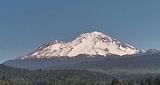
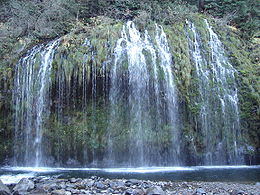 Siskiyou County is geographically diverse. From towering Mount Shasta
(elev. 14,179 ft/(4,322 m)) near the center of the county, to lakes and dense forests, as well as desert, chaparral, and memorable waterfalls, the county is home to world-famous trout-fishing rivers and streams, such as the Sacramento
and McCloud
Rivers. The county is dotted as well with lakes and reservoirs, such as Castle Lake
and Lake Siskiyou
. Mount Shasta itself has a winter sports center. Pastoral Scott Valley
in the western part of the county has many wide, tree-lined meadows, supporting large cattle ranches. The basins of northeastern Siskiyou County, including Butte Valley, Lower Klamath and Tule Lake basins, have some of the deepest and richest soils in the state, producing alfalfa, potatoes, horseradish, and brewing barley. Butte Valley nurseries are the leading source of premium strawberry plants in North America. Much of the county is densely forested with pine
, fir
, incense-cedar
, oak
, and madrone; Siskiyou County is also home to the rare Baker's Cypress Tree, Cupressus bakeri
, which grows in only eleven scattered locations in the world, five of which are in Siskiyou County.
The county's natural resources are most often used these days for skiing, snowboarding, hiking
, mountain biking
, camping
, and wilderness recreation, as historic logging practices have been largely discontinued due to Federal and State environmental regulations. The county’s water is viewed as sufficiently pure and abundant that the county is a source of significant amounts of bottled water, distributed throughout the country. A large Crystal Geyser plant is located at the base of Mt. Shasta, near Weed.
While it ranks fifth in area among California counties (and is larger than three U.S. states), with some 6347 square miles (16,438.7 km²), it only ranked 44th in population among California’s 58 counties; as of 2000, the population was 44,301.
trains stop in Dunsmuir. Amtrak California
motorcoaches operate from Sacramento and Medford, OR, with stops in Yreka, Weed, Mount Shasta, and Dunsmuir, for passengers connecting to and from Amtrak
trains in Sacramento or Stockton.
, Happy Camp Airport
, Scott Valley Airport
, Siskiyou County Airport
and Weed Airport
(all general aviation). Dunsmuir Municipal-Mott Airport
and Montague-Yreka Rohrer Field
are also located within the county.
The closest airports where commercial domestic planes depart from is Rogue Valley International-Medford Airport
north of the county in Medford, Oregon
, Klamath Falls International Airport, northeast of the county in Klamath Falls, Oregon
,and Redding Municipal Airport
south of the county in Redding, California
.
Siskiyou is a strongly Republican county in Presidential
and congressional
elections. The last Democrat to win a plurality in the county was Bill Clinton
in 1992
. Siskiyou is part of California's 2nd congressional district
, which is held by Republican Wally Herger
. In the state legislature
Siskiyou is in the 2nd Assembly district, which is held by Republican Jim Nielsen
, and the 4th Senate district, which is held by Republican Doug LaMalfa
.
On Nov. 4, 2008 Siskiyou County voted 60.1 % for Proposition 8 which amended the California Constitution to ban same-sex marriages.
, and 2,374 (5.3%) from two or more races. Hispanic or Latino of any race were 4,615 persons (10.3%).
of 2000, there were 44,301 people, 18,556 households, and 12,228 families residing in the county. The population density
was 7/sq mi (3/km2). There were 21,947 housing units at an average density of 4/sq mi (1/km2). The racial makeup of the county was 87.07% White
, 1.31% Black
or African American
, 3.90% Native American
, 1.19% Asian
, 0.13% Pacific Islander
, 2.76% from other races
, and 3.65% from two or more races. 7.57% of the population were Hispanic
or Latino
of any race. 13.5% were of German, 12.0% English
, 9.8% Irish
, 9.5% American and 7.1% Italian
ancestry according to Census 2000. 91.7% spoke English and 5.7% Spanish as their first language.
There were 18,556 households out of which 27.6% had children under the age of 18 living with them, 51.7% were married couples
living together, 10.1% had a female householder with no husband present, and 34.1% were non-families. 28.6% of all households were made up of individuals and 12.8% had someone living alone who was 65 years of age or older. The average household size was 2.35 and the average family size was 2.87.
In the county the population was spread out with 24.0% under the age of 18, 6.7% from 18 to 24, 22.7% from 25 to 44, 28.4% from 45 to 64, and 18.1% who were 65 years of age or older. The median age was 43 years. For every 100 females there were 96.5 males. For every 100 females age 18 and over, there were 94.1 males.
The median income for a household in the county was $29,530, and the median income for a family was $36,890. Males had a median income of $31,936 versus $22,650 for females. The per capita income
for the county was $17,570. About 14.0% of families and 18.6% of the population were below the poverty line, including 26.6% of those under age 18 and 7.3% of those age 65 or over.
occupies 1700000 acres (6,879.7 km²) of land which includes elements in Siskiyou County as well as Jackson County, Oregon
.
County (United States)
In the United States, a county is a geographic subdivision of a state , usually assigned some governmental authority. The term "county" is used in 48 of the 50 states; Louisiana is divided into parishes and Alaska into boroughs. Parishes and boroughs are called "county-equivalents" by the U.S...
located in the far northernmost part of the U.S. state
U.S. state
A U.S. state is any one of the 50 federated states of the United States of America that share sovereignty with the federal government. Because of this shared sovereignty, an American is a citizen both of the federal entity and of his or her state of domicile. Four states use the official title of...
of California
California
California is a state located on the West Coast of the United States. It is by far the most populous U.S. state, and the third-largest by land area...
, in the Shasta Cascade
Shasta Cascade
The Shasta Cascade region of California is located in the northeastern and north-central sections of the state bordering Oregon and Nevada, including far northern parts of the Central Valley and the Sierra Nevada mountain range. The area is centered on Mount Shasta in the California Cascade Range,...
region on the Oregon
Oregon
Oregon is a state in the Pacific Northwest region of the United States. It is located on the Pacific coast, with Washington to the north, California to the south, Nevada on the southeast and Idaho to the east. The Columbia and Snake rivers delineate much of Oregon's northern and eastern...
border. Yreka
Yreka, California
Yreka is the county seat of Siskiyou County, California, United States. The population was 7,765 at the 2010 census, up from 7,290 at the 2000 census.- History:...
is the county seat
County seat
A county seat is an administrative center, or seat of government, for a county or civil parish. The term is primarily used in the United States....
. Because of its substantial natural beauty, outdoor recreation opportunities, and Gold Rush era
California Gold Rush
The California Gold Rush began on January 24, 1848, when gold was found by James W. Marshall at Sutter's Mill in Coloma, California. The first to hear confirmed information of the gold rush were the people in Oregon, the Sandwich Islands , and Latin America, who were the first to start flocking to...
history, it is an important tourist destination within the state. The population was 44,900 at the 2010 census.
History
Siskiyou County was created on March 22, 1852, from parts of ShastaShasta County, California
Shasta County is a county located in the northern portion of the U.S. state of California. The county occupies the northern reaches of the Sacramento Valley, with portions extending into the southern reaches of the Cascade Range. As of the 2010 census, the population was 177,223, up from 163,256...
and Klamath
Klamath County, California
Klamath County was a county of California from 1851 to 1874. During its existence, the county seat moved twice and several counties were carved from its territory...
Counties, and named after the Siskiyou mountain range
Siskiyou Mountains
The Siskiyou Mountains are a coastal mountain range in the northern Klamath Mountains in northwestern California and southwestern Oregon in the United States. They extend in an arc for approximately from east of Crescent City, California northeast along the north side of the Klamath River into...
. Parts of the county's territory were given to Modoc County
Modoc County, California
Modoc County is a county located in the far northeast corner of the U.S. state of California, bounded by the state of Oregon to the north and the state of Nevada to the east. As of the 2010 census, its population was 9,686, up from 9,449 at the 2000 census. The current county seat is Alturas, the...
in 1855.
The county is the site of the central section of the Siskiyou Trail
Siskiyou Trail
The Siskiyou Trail stretched from California's Central Valley to Oregon's Willamette Valley; modern-day Interstate 5 follows this pioneer path...
, which ran between California's Central Valley and the Pacific Northwest
Pacific Northwest
The Pacific Northwest is a region in northwestern North America, bounded by the Pacific Ocean to the west and, loosely, by the Rocky Mountains on the east. Definitions of the region vary and there is no commonly agreed upon boundary, even among Pacific Northwesterners. A common concept of the...
. The Siskiyou Trail was based on Native American footpaths, was expanded by Hudson's Bay Company
Hudson's Bay Company
The Hudson's Bay Company , abbreviated HBC, or "The Bay" is the oldest commercial corporation in North America and one of the oldest in the world. A fur trading business for much of its existence, today Hudson's Bay Company owns and operates retail stores throughout Canada...
trappers in the 1830s, and was expanded still further by "Forty-Niners
California Gold Rush
The California Gold Rush began on January 24, 1848, when gold was found by James W. Marshall at Sutter's Mill in Coloma, California. The first to hear confirmed information of the gold rush were the people in Oregon, the Sandwich Islands , and Latin America, who were the first to start flocking to...
" during the California Gold Rush
California Gold Rush
The California Gold Rush began on January 24, 1848, when gold was found by James W. Marshall at Sutter's Mill in Coloma, California. The first to hear confirmed information of the gold rush were the people in Oregon, the Sandwich Islands , and Latin America, who were the first to start flocking to...
.
In 1851, after the discovery of an important gold strike near today’s Yreka, California
Yreka, California
Yreka is the county seat of Siskiyou County, California, United States. The population was 7,765 at the 2010 census, up from 7,290 at the 2000 census.- History:...
, thousands of prospectors flooded the area. This era and setting was described in detail in the semi-autobiographical novel, Life Amongst the Modocs, written by poet and novelist Joaquin Miller
Joaquin Miller
Joaquin Miller was the pen name of the colorful American poet Cincinnatus Heine Miller , nicknamed the "Poet of the Sierras".-Early years and family:...
.
The construction of the Central Pacific Railroad
Central Pacific Railroad
The Central Pacific Railroad is the former name of the railroad network built between California and Utah, USA that formed part of the "First Transcontinental Railroad" in North America. It is now part of the Union Pacific Railroad. Many 19th century national proposals to build a transcontinental...
along the path of the Siskiyou Trail in the mid-1880s led to a first wave of tourism, as visitors came to “take the waters” at the county’s many summer resorts
Upper Soda Springs
Upper Soda Springs is on the banks of the Sacramento River in Dunsmuir, California, USA. It consists of approximately ten acres of level ground on both sides of the River, the surrounding hillsides, and continues north along the eastern bank of the Sacramento River to the Dunsmuir City Park...
, and to enjoy the hunting
Hunting
Hunting is the practice of pursuing any living thing, usually wildlife, for food, recreation, or trade. In present-day use, the term refers to lawful hunting, as distinguished from poaching, which is the killing, trapping or capture of the hunted species contrary to applicable law...
, fishing and other outdoor recreation activities. The Southern Pacific
Southern Pacific Railroad
The Southern Pacific Transportation Company , earlier Southern Pacific Railroad and Southern Pacific Company, and usually simply called the Southern Pacific or Espee, was an American railroad....
railroad (successor to the Central Pacific) promoted the scenic beauty of the area by calling its rail line through the area “The Road of A Thousand Wonders.”
In the early 1940s, Siskiyou County was home to the semi-serious State of Jefferson movement, which sought to create a new state from several counties of northern California, and several counties of southern Oregon.
The origin of the word siskiyou is not known. One version is that it is the Chinook Jargon
Chinook Jargon
Chinook Jargon originated as a pidgin trade language of the Pacific Northwest, and spread during the 19th century from the lower Columbia River, first to other areas in modern Oregon and Washington, then British Columbia and as far as Alaska, sometimes taking on characteristics of a creole language...
word for "bob-tailed horse." Another version, given in an argument before the State Senate in 1852, is that the French name Six Cailloux, meaning "six stones," was given to a ford on the Umpqua River
Umpqua River
The Umpqua River on the Pacific coast of Oregon in the United States is approximately long. One of the principal rivers of the Oregon Coast and known for bass and shad, the river drains an expansive network of valleys in the mountains west of the Cascade Range and south of the Willamette Valley,...
by Michel LaFrambois and a party of Hudson's Bay Company trappers in 1832, because six large stones or rocks lay in the river where they crossed. According to some, the Six Cailloux name was appropriated to this region by Stephen Meek
Stephen Meek
Stephen Hall Meek was a fur trapper and guide in the American west, most notably a guide on a large wagon train known as St. Joseph's Company...
, another Hudson's Bay Company trapper who was known for his "discovery" of Scott Valley, in regard to a crossing on the Klamath River
Klamath River
The Klamath River is an American river that flows southwest through Oregon and northern California, cutting through the Cascade Range to empty into the Pacific Ocean. The river drains an extensive watershed of almost that stretches from the high desert country of the Great Basin to the temperate...
near Hornbrook
Hornbrook, California
Hornbrook is a census-designated place in Siskiyou County, California, United States. The population was 248 at the 2010 census, down from 286 at the 2000 census.-Geography:Hornbrook is located at ....
.
The County is also home to the Black Bear Ranch
Black Bear Ranch
Black Bear Ranch is an 80-acre intentional community located in Siskiyou County, California, founded in 1968, with the slogan "free land for free people"...
, a commune started in 1968 with the slogan "Free Land for free people." The commune is still around today.
Geography
Mount Shasta
Mount Shasta is located at the southern end of the Cascade Range in Siskiyou County, California and at is the second highest peak in the Cascades and the fifth highest in California...
(elev. 14,179 ft/(4,322 m)) near the center of the county, to lakes and dense forests, as well as desert, chaparral, and memorable waterfalls, the county is home to world-famous trout-fishing rivers and streams, such as the Sacramento
Sacramento River
The Sacramento River is an important watercourse of Northern and Central California in the United States. The largest river in California, it rises on the eastern slopes of the Klamath Mountains, and after a journey south of over , empties into Suisun Bay, an arm of the San Francisco Bay, and...
and McCloud
McCloud River
The McCloud River is a river that flows east of and parallel to the Sacramento River, long, in northern California in the United States. It drains a scenic mountainous area of the Cascade Range north of Redding...
Rivers. The county is dotted as well with lakes and reservoirs, such as Castle Lake
Castle Lake (California)
Castle Lake is a glacial lake located in northern California along the eastern edge of the Klamath Mountains, in Siskiyou County, near the city of Mount Shasta. The outlet of the lake drains into Castle Lake Creek, and then into Lake Siskiyou; the lake is part of the headwaters of the Sacramento...
and Lake Siskiyou
Lake Siskiyou
Lake Siskiyou is a reservoir formed by Box Canyon Dam on the Sacramento River, in far northern California, near the town of Mount Shasta, California. It is the site of local recreation, as well as being used for watershed protection and flood control....
. Mount Shasta itself has a winter sports center. Pastoral Scott Valley
Scott Valley
Scott Valley is a large, scenic rural area of western Siskiyou County, California, known for its vistas of the Marble Mountains, cattle and dairy ranches, and its historic background as a gold mining area, dating back to the days of the California Gold Rush...
in the western part of the county has many wide, tree-lined meadows, supporting large cattle ranches. The basins of northeastern Siskiyou County, including Butte Valley, Lower Klamath and Tule Lake basins, have some of the deepest and richest soils in the state, producing alfalfa, potatoes, horseradish, and brewing barley. Butte Valley nurseries are the leading source of premium strawberry plants in North America. Much of the county is densely forested with pine
Pine
Pines are trees in the genus Pinus ,in the family Pinaceae. They make up the monotypic subfamily Pinoideae. There are about 115 species of pine, although different authorities accept between 105 and 125 species.-Etymology:...
, fir
Fir
Firs are a genus of 48–55 species of evergreen conifers in the family Pinaceae. They are found through much of North and Central America, Europe, Asia, and North Africa, occurring in mountains over most of the range...
, incense-cedar
Calocedrus
Calocedrus is a genus of three species of coniferous trees in the cypress family Cupressaceae.The generic name means "beautiful cedar".-Description:...
, oak
Oak
An oak is a tree or shrub in the genus Quercus , of which about 600 species exist. "Oak" may also appear in the names of species in related genera, notably Lithocarpus...
, and madrone; Siskiyou County is also home to the rare Baker's Cypress Tree, Cupressus bakeri
Cupressus bakeri
Cupressus bakeri, the Modoc Cypress, Siskiyou Cypress or Baker Cypress, is a species of cypress native to a small area in the western United States, located in California and Oregon.-Distribution:...
, which grows in only eleven scattered locations in the world, five of which are in Siskiyou County.
The county's natural resources are most often used these days for skiing, snowboarding, hiking
Hiking
Hiking is an outdoor activity which consists of walking in natural environments, often in mountainous or other scenic terrain. People often hike on hiking trails. It is such a popular activity that there are numerous hiking organizations worldwide. The health benefits of different types of hiking...
, mountain biking
Mountain biking
Mountain biking is a sport which consists of riding bicycles off-road, often over rough terrain, using specially adapted mountain bikes. Mountain bikes share similarities with other bikes, but incorporate features designed to enhance durability and performance in rough terrain.Mountain biking can...
, camping
Camping
Camping is an outdoor recreational activity. The participants leave urban areas, their home region, or civilization and enjoy nature while spending one or several nights outdoors, usually at a campsite. Camping may involve the use of a tent, caravan, motorhome, cabin, a primitive structure, or no...
, and wilderness recreation, as historic logging practices have been largely discontinued due to Federal and State environmental regulations. The county’s water is viewed as sufficiently pure and abundant that the county is a source of significant amounts of bottled water, distributed throughout the country. A large Crystal Geyser plant is located at the base of Mt. Shasta, near Weed.
While it ranks fifth in area among California counties (and is larger than three U.S. states), with some 6347 square miles (16,438.7 km²), it only ranked 44th in population among California’s 58 counties; as of 2000, the population was 44,301.
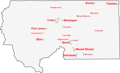
Cities over 5,000 population
- YrekaYreka, CaliforniaYreka is the county seat of Siskiyou County, California, United States. The population was 7,765 at the 2010 census, up from 7,290 at the 2000 census.- History:...
(County SeatCounty seatA county seat is an administrative center, or seat of government, for a county or civil parish. The term is primarily used in the United States....
)
Cities over 1,000 population
- DunsmuirDunsmuir, CaliforniaDunsmuir is a city in Siskiyou County, California, United States. The population was 1,650 at the 2010 census, down from 1,923 at the 2000 census. It is currently a hub of tourism in Northern California as visitors enjoy fishing, skiing, climbing, or sight-seeing...
- MontagueMontague, CaliforniaMontague is a city in Siskiyou County, California, United States. The population was 1,443 at the 2010 census, down from 1,456 at the 2000 census.-Geography:Montague is located at ....
- Mount ShastaMount Shasta, CaliforniaMount Shasta is a city in Siskiyou County, California, located at around 3,600 ft on the flanks of Mount Shasta, a prominent northern California landmark. The city is less than southwest of the summit of its namesake volcano...
- TulelakeTulelake, CaliforniaTulelake is a city in Siskiyou County, California, United States. It is named after the nearby Tule Lake. The population was 1,010 at the 2010 census, down from 1,020 at the 2000 census.-Geography:Tulelake is located at ....
- WeedWeed, CaliforniaWeed is a city located in Siskiyou County, California. As of the 2010 Census, the town had a total population of 2,967, down from 2,979 at the 2000 census. There are several unincorporated communities adjacent to, or just outside Weed proper. These include Edgewood, Carrick, Lake Shastina, Rancho...
Cities under 1,000 population
- DorrisDorris, CaliforniaDorris is a city in Siskiyou County, California, United States. The population was 939 at the 2010 census, up from 886 at the 2000 census.-Geography:...
- EtnaEtna, CaliforniaEtna is a city in the Scott Valley area of Siskiyou County, California, United States. The population was 737 at the 2010 census, down from 781 at the 2000 census.-Geography:...
- Fort JonesFort Jones, CaliforniaFort Jones is a city in the Scott Valley area of Siskiyou County, California, United States. The population was 839 at the 2010 census, up from 600 as of the 2000 census.-History:...
Unincorporated towns and CDPs
- Big Springs
- CallahanCallahan, CaliforniaCallahan is an unincorporated community in Siskiyou County, California, United States. Callahan is located on California State Route 3 south-southeast of Etna. Callahan has a post office with ZIP code 96014. The post office opened as Callahan's Ranch in 1858 and changed its name to Callahan in...
- CarrickCarrick, CaliforniaCarrick is a census-designated place in Siskiyou County, California, United States. The population was 131 at the 2010 census, down from 156 at the 2000 census...
- Clear Creek
- EdgewoodEdgewood, CaliforniaEdgewood is a census-designated place in Siskiyou County, California, United States. The population was 43 at the 2010 census, down from 67 at the 2000 census...
- Forks of SalmonForks of Salmon, CaliforniaForks of Salmon is an unincorporated community of Siskiyou County in northern California, USA. The town is situated at the confluence of the north and south forks of the Salmon River, hence its name. The ZIP Code is 96031...
- Fort Goff
- GazelleGazelle, CaliforniaGazelle is a census-designated place in Siskiyou County, California, United States. The population was 70 at the 2010 census, down from 136 at the 2000 census.-Geography:Gazelle is located at ....
- GreenviewGreenview, CaliforniaGreenview is a census-designated place in Siskiyou County, California, United States. The population was 201 at the 2010 census, up from 200 at the 2000 census.-Geography:Greenview is located at ....
- GrenadaGrenada, CaliforniaGrenada is a census-designated place in Siskiyou County, California, United States. The population was 367 at the 2010 census, up from 351 at the 2000 census...
- Hamburg
- Hatfield
- Happy CampHappy Camp, CaliforniaHappy Camp is a census-designated place in Siskiyou County, California in the United States. The population was 1,190 at the 2010 census....
- Hilt
- HornbrookHornbrook, CaliforniaHornbrook is a census-designated place in Siskiyou County, California, United States. The population was 248 at the 2010 census, down from 286 at the 2000 census.-Geography:Hornbrook is located at ....
- Horse CreekHorse Creek, CaliforniaHorse Creek is an unincorporated community in Siskiyou County, California, United States. Horse Creek is located along California State Route 96 west-northwest of Yreka....
- Klamath RiverKlamath River, CaliforniaKlamath River is an unincorporated community in Siskiyou County, California, United States, situated on the Klamath River. It is located on State Route 96, near the Oregon border. The name "Klamath" was derived from an Indian word Tlamatl which means "swiftness" in Chinook...
- Klamathon
- Lake Shastina
- Lake Siskiyou
- MacdoelMacdoel, CaliforniaMacdoel is a census-designated place in Siskiyou County, California, United States. As of the 2010 census, the CDP population was 133, down from 140 in at the 2000 census.-Geography:Macdoel is located at ....
- McCloudMcCloud, CaliforniaMcCloud is a small town and census-designated place in Siskiyou County, California, United States. The population was 1,101 at the 2010 census, down from 1,343 at the 2000 census.-Commerce and tourism:...
- Mount HebronMount Hebron, CaliforniaMount Hebron is a census-designated place in Siskiyou County, California, United States. The population was 95 at the 2010 census, up from 92 at the 2000 census.-Geography:Mount Hebron is located at ....
- Mugginsville
- Sawyers Bar
- Seiad ValleySeiad Valley, CaliforniaSeiad Valley is a small unincorporated town in Siskiyou County, California situated 15 miles south of the Oregon border. A population of approximately 300 people is clustered around the Klamath River, State Route 96 and spread out along the surrounding creeks...
- TennantTennant, CaliforniaTennant is a census-designated place in Siskiyou County, California, United States. The population was 41 at the 2010 census, down from 63 at the 2000 census.-Geography:Tennant is located at ....
- Thompson Creek
Adjacent Counties
|
National protected areas
- Butte Valley National GrasslandButte Valley National GrasslandButte Valley National Grassland is a 18,425 acre United States National Grassland located in northern California. Administered by the United States Forest Service, it is located in northern Siskiyou County, near the Oregon border, between the communities of Dorris and Macdoel along U.S. Highway 97...
- Klamath National ForestKlamath National ForestKlamath National Forest is a national forest, in the Klamath Mountains, located in Siskiyou County in northern California, but with a tiny extension into southern Jackson County in Oregon. The forest contains continuous stands of ponderosa pine, Jeffrey pine, Douglas fir, red fir, white fir and...
(part) - Lava Beds National MonumentLava Beds National MonumentLava Beds National Monument is located in northeastern California, in Siskiyou and Modoc Counties. The Monument lies on the northeastern flank of the Medicine Lake Volcano, with the largest total area covered by a volcano in the Cascade Range....
(part) - Lower Klamath National Wildlife RefugeLower Klamath National Wildlife RefugeThe Lower Klamath National Wildlife Refuge is a wildlife preserve operated by the United States Fish and Wildlife Service located in the Klamath Basin along a portion of the northern California and southern Oregon border near Klamath Falls, Oregon...
(part) - Modoc National ForestModoc National ForestModoc National Forest is a national forest in northeastern California, covering parts of Modoc , Lassen , and Siskiyou counties. Most of the forest was covered by an immense lava flow millions of years ago. The eastern part of the forest east of Alturas contains a spur of the Cascade Range to...
(part) - Rogue River National Forest (part)
- Shasta National Forest (part)
- Six Rivers National ForestSix Rivers National ForestSix Rivers National Forest is a U.S. National Forest located in the northwestern corner of California. It was established on July 1, 1947 by U.S. President Harry S. Truman from portions of Klamath, Siskiyou and Trinity National Forests. Its over one million acres of land contain a variety of...
(part) - Tule Lake National Wildlife RefugeTule Lake National Wildlife RefugeThe Tule Lake National Wildlife Refuge is a wildlife preserve operated by the United States Fish and Wildlife Service located in the Klamath Basin in northern California near the Oregon border south of Klamath Falls, Oregon....
(part)
Major Highways
- Interstate 5
.svg.png) Interstate 5 in CaliforniaInterstate 5 is a major north–south route of the Interstate Highway System in the U.S. state of California. It begins at the Mexico – United States border at the San Ysidro crossing, goes north across the length of California and crosses into Oregon south of the Medford-Ashland metropolitan...
Interstate 5 in CaliforniaInterstate 5 is a major north–south route of the Interstate Highway System in the U.S. state of California. It begins at the Mexico – United States border at the San Ysidro crossing, goes north across the length of California and crosses into Oregon south of the Medford-Ashland metropolitan... - U.S. Route 97
.svg.png) U.S. Route 97 in CaliforniaIn the U.S. state of California, U.S. Route 97 runs north from I-5 in Weed to the Oregon state line. This is the majority of a shortcut between I-5 and Klamath Falls, Oregon, added to both states' state highway systems in 1931.-Route description:...
U.S. Route 97 in CaliforniaIn the U.S. state of California, U.S. Route 97 runs north from I-5 in Weed to the Oregon state line. This is the majority of a shortcut between I-5 and Klamath Falls, Oregon, added to both states' state highway systems in 1931.-Route description:... - State Route 3

- State Route 89
 California State Route 89State Route 89 is a California State Highway that travels in the north–south direction, and is the major thoroughfare for many mountain communities. It starts from U.S. Route 395 near Topaz Lake, winding its way up to the Monitor Pass, down to the Carson River, and up again over the Luther...
- State Route 96
 California State Route 96State Route 96 follows the Trinity and Klamath Rivers in Northern California. For most of the route it goes through the Karuk Tribal Reservation, the Yurok Tribal Reservation, and the Hoopa Tribal Reservation...
 - State Route 139
 California State Route 139State Route 139 is a state highway in the U.S. state of California. Running from Susanville north to Oregon Route 39, it forms part of the shortest route between Reno, Nevada and Klamath Falls, Oregon. The entire route is part of the California Freeway and Expressway System, but is a two-lane road...
 - State Route 161

- State Route 263
 California State Route 263State Route 263 is a state highway in the U.S. state of California in Siskiyou County. It is also part of Business Loop 5 due to being a parallel route of Interstate 5 to the west. Route 263 connects Route 3 near the north city limits of Yreka to Route 96 eight miles north. It was once part of...
 - State Route 265
 California State Route 265State Route 265 , part of Weed Boulevard, is a state highway in the U.S. state of California in Siskiyou County.-Route description:...
Public Transportation
Siskiyou Transit And General Express (STAGE) operates buses connecting the more populated areas of the county. AmtrakAmtrak
The National Railroad Passenger Corporation, doing business as Amtrak , is a government-owned corporation that was organized on May 1, 1971, to provide intercity passenger train service in the United States. "Amtrak" is a portmanteau of the words "America" and "track". It is headquartered at Union...
trains stop in Dunsmuir. Amtrak California
Amtrak California
Amtrak California is a brand name used by the Caltrans Division of Rail for all state-supported Amtrak rail routes within the U.S. State of California...
motorcoaches operate from Sacramento and Medford, OR, with stops in Yreka, Weed, Mount Shasta, and Dunsmuir, for passengers connecting to and from Amtrak
Amtrak
The National Railroad Passenger Corporation, doing business as Amtrak , is a government-owned corporation that was organized on May 1, 1971, to provide intercity passenger train service in the United States. "Amtrak" is a portmanteau of the words "America" and "track". It is headquartered at Union...
trains in Sacramento or Stockton.
Airports
Siskiyou County owns and operates Butte Valley AirportButte Valley Airport
Butte Valley Airport is a county-owned public-use airport located five miles southwest of the central business district of Dorris, in Siskiyou County, California, United States.- Facilities and aircraft :...
, Happy Camp Airport
Happy Camp Airport
Happy Camp Airport is a public airport located in the city of Happy Camp, serving Siskiyou County, California, USA. The airport has one runway and is mostly used for general aviation.- Facilities :Happy Camp Airport has one runway:...
, Scott Valley Airport
Scott Valley Airport
Scott Valley Airport , formerly CA06, is a public airport located three miles south of the central business district of Fort Jones, a city in Siskiyou County, California, USA. The airport covers 53 acres and has one runway....
, Siskiyou County Airport
Siskiyou County Airport
Siskiyou County Airport is a public airport located three miles northeast of Montague, serving Siskiyou County, California, USA. The airport has one runway and is mostly used for general aviation.- Facilities :Siskiyou County Airport has one runway:...
and Weed Airport
Weed Airport
Weed Airport is a public airport located four miles northwest of Weed, serving Siskiyou County, California, USA. This general aviation airport covers and has one runway.- References :*...
(all general aviation). Dunsmuir Municipal-Mott Airport
Dunsmuir Municipal-Mott Airport
Dunsmuir Municipal-Mott Airport is a city-owned public-use airport located three nautical miles north of the central business district of Dunsmuir, a city in Siskiyou County, California, United States.- Facilities and aircraft :...
and Montague-Yreka Rohrer Field
Montague Airport (California)
The Montague Airport or Yreka Rohrer Field is located on the west side of Montague, California. It is owned by the City of Montague....
are also located within the county.
The closest airports where commercial domestic planes depart from is Rogue Valley International-Medford Airport
Rogue Valley International-Medford Airport
Rogue Valley International-Medford Airport is a public airport located 3 miles north of downtown Medford in Jackson County, Oregon, USA. In addition to Jackson County, the airport serves seven nearby counties in southwest Oregon. It is owned and operated by Jackson County's Aviation Authority...
north of the county in Medford, Oregon
Medford, Oregon
Medford is a city in Jackson County, Oregon, United States. As of the 2010 US Census, the city had a total population of 74,907 and a metropolitan area population of 207,010, making the Medford MSA the 4th largest metro area in Oregon...
, Klamath Falls International Airport, northeast of the county in Klamath Falls, Oregon
Klamath Falls, Oregon
Klamath Falls is a city in Klamath County, Oregon, United States. Originally called Linkville when George Nurse founded the town in 1867, after the Link River on whose falls this city sat, although no falls currently exist; the name was changed to Klamath Falls in 1892...
,and Redding Municipal Airport
Redding Municipal Airport
-References:* Maurer, Maurer . Air Force Combat Units Of World War II. Maxwell AFB, Alabama: Office of Air Force History. ISBN 0-89201-092-4.-External links:* at City of Redding web site...
south of the county in Redding, California
Redding, California
Redding is a city in far-Northern California. It is the county seat of Shasta County, California, USA. With a population of 89,861, according to the 2010 Census...
.
Politics
| Year | GOP Republican Party (United States) The Republican Party is one of the two major contemporary political parties in the United States, along with the Democratic Party. Founded by anti-slavery expansion activists in 1854, it is often called the GOP . The party's platform generally reflects American conservatism in the U.S... |
DEM Democratic Party (United States) The Democratic Party is one of two major contemporary political parties in the United States, along with the Republican Party. The party's socially liberal and progressive platform is largely considered center-left in the U.S. political spectrum. The party has the lengthiest record of continuous... |
Others |
|---|---|---|---|
| 2008 United States presidential election, 2008 The United States presidential election of 2008 was the 56th quadrennial presidential election. It was held on November 4, 2008. Democrat Barack Obama, then the junior United States Senator from Illinois, defeated Republican John McCain, the senior U.S. Senator from Arizona. Obama received 365... |
43.3% 9,292 | 3.5% 752 | |
| 2004 United States presidential election, 2004 The United States presidential election of 2004 was the United States' 55th quadrennial presidential election. It was held on Tuesday, November 2, 2004. Republican Party candidate and incumbent President George W. Bush defeated Democratic Party candidate John Kerry, the then-junior U.S. Senator... |
37.7% 7,880 | 1.7% 346 | |
| 2000 United States presidential election, 2000 The United States presidential election of 2000 was a contest between Republican candidate George W. Bush, then-governor of Texas and son of former president George H. W. Bush , and Democratic candidate Al Gore, then-Vice President.... |
31.9% 6,323 | 6.6% 1,298 | |
| 1996 United States presidential election, 1996 The United States presidential election of 1996 was a contest between the Democratic national ticket of President Bill Clinton of Arkansas and Vice President Al Gore of Tennessee and the Republican national ticket of former Senator Bob Dole of Kansas for President and former Housing Secretary Jack... |
38.4% 7,022 | 14.3% 2,618 | |
| 1992 United States presidential election, 1992 The United States presidential election of 1992 had three major candidates: Incumbent Republican President George Bush; Democratic Arkansas Governor Bill Clinton, and independent Texas businessman Ross Perot.... |
39.9% 8,254 | 27.9% 5,765 | |
| 1988 United States presidential election, 1988 The United States presidential election of 1988 featured no incumbent president, as President Ronald Reagan was unable to seek re-election after serving the maximum two terms allowed by the Twenty-second Amendment. Reagan's Vice President, George H. W. Bush, won the Republican nomination, while the... |
47.0% 8,365 | 2.1% 376 | |
| 1984 United States presidential election, 1984 The United States presidential election of 1984 was a contest between the incumbent President Ronald Reagan, the Republican candidate, and former Vice President Walter Mondale, the Democratic candidate. Reagan was helped by a strong economic recovery from the deep recession of 1981–1982... |
39.4% 7,130 | 2.4% 427 | |
| 1980 United States presidential election, 1980 The United States presidential election of 1980 featured a contest between incumbent Democrat Jimmy Carter and his Republican opponent, Ronald Reagan, as well as Republican Congressman John B. Anderson, who ran as an independent... |
33.8% 5,664 | 10.4% 1,743 | |
| 1976 United States presidential election, 1976 The United States presidential election of 1976 followed the resignation of President Richard Nixon in the wake of the Watergate scandal. It pitted incumbent President Gerald Ford, the Republican candidate, against the relatively unknown former governor of Georgia, Jimmy Carter, the Democratic... |
48.3% 7,060 | 3.3% 485 | |
| 1972 United States presidential election, 1972 The United States presidential election of 1972 was the 47th quadrennial United States presidential election. It was held on November 7, 1972. The Democratic Party's nomination was eventually won by Senator George McGovern, who ran an anti-war campaign against incumbent Republican President Richard... |
43.8% 6,434 | 4.8% 699 | |
| 1968 United States presidential election, 1968 The United States presidential election of 1968 was the 46th quadrennial United States presidential election. Coming four years after Democrat Lyndon B. Johnson won in a historic landslide, it saw Johnson forced out of the race and Republican Richard Nixon elected... |
45.6% 6,260 | 8.3% 1,138 | |
| 1964 United States presidential election, 1964 The United States presidential election of 1964 was held on November 3, 1964. Incumbent President Lyndon B. Johnson had come to office less than a year earlier following the assassination of his predecessor, John F. Kennedy. Johnson, who had successfully associated himself with Kennedy's... |
63.7% 9,126 | 0.2% 23 | |
| 1960 United States presidential election, 1960 The United States presidential election of 1960 was the 44th American presidential election, held on November 8, 1960, for the term beginning January 20, 1961, and ending January 20, 1965. The incumbent president, Republican Dwight D. Eisenhower, was not eligible to run again. The Republican Party... |
56.4% 8,245 | 0.7% 96 | |
| 1956 United States presidential election, 1956 The United States presidential election of 1956 saw a popular Dwight D. Eisenhower successfully run for re-election. The 1956 election was a rematch of 1952, as Eisenhower's opponent in 1956 was Democrat Adlai Stevenson, whom Eisenhower had defeated four years earlier.Incumbent President Eisenhower... |
49.8% 6,837 | 0.5% 63 | |
| 1952 United States presidential election, 1952 The United States presidential election of 1952 took place in an era when Cold War tension between the United States and the Soviet Union was escalating rapidly. In the United States Senate, Republican Senator Joseph McCarthy of Wisconsin had become a national figure after chairing congressional... |
43.4% 6,800 | 1.0% 151 | |
| 1948 United States presidential election, 1948 The United States presidential election of 1948 is considered by most historians as the greatest election upset in American history. Virtually every prediction indicated that incumbent President Harry S. Truman would be defeated by Republican Thomas E. Dewey. Truman won, overcoming a three-way... |
54.0% 6,749 | 3.5% 434 | |
| 1944 United States presidential election, 1944 The United States presidential election of 1944 took place while the United States was preoccupied with fighting World War II. President Franklin D. Roosevelt had been in office longer than any other president, but remained popular. Unlike 1940, there was little doubt that Roosevelt would run for... |
57.3% 5,914 | 0.6% 58 | |
| 1940 United States presidential election, 1940 The United States presidential election of 1940 was fought in the shadow of World War II as the United States was emerging from the Great Depression. Incumbent President Franklin D. Roosevelt , a Democrat, broke with tradition and ran for a third term, which became a major issue... |
63.2% 7,714 | 0.9% 111 | |
| 1936 United States presidential election, 1936 The United States presidential election of 1936 was the most lopsided presidential election in the history of the United States in terms of electoral votes. In terms of the popular vote, it was the third biggest victory since the election of 1820, which was not seriously contested.The election took... |
69.3% 6,865 | 1.3% 125 | |
| 1932 United States presidential election, 1932 The United States presidential election of 1932 took place as the effects of the Wall Street Crash of 1929, the Smoot-Hawley Tariff Act of 1930, the Revenue Act of 1932, and the Great Depression were being felt intensely across the country. President Herbert Hoover's popularity was falling as... |
69.3% 6,367 | 3.9% 359 | |
| 1928 United States presidential election, 1928 The United States presidential election of 1928 pitted Republican Herbert Hoover against Democrat Al Smith. The Republicans were identified with the booming economy of the 1920s, whereas Smith, a Roman Catholic, suffered politically from Anti-Catholic prejudice, his anti-prohibitionist stance, and... |
43.1% 2,916 | 1.5% 98 | |
| 1924 United States presidential election, 1924 The United States presidential election of 1924 was won by incumbent President Calvin Coolidge, the Republican candidate.Coolidge was vice-president under Warren G. Harding and became president in 1923 when Harding died in office. Coolidge was given credit for a booming economy at home and no... |
9.7% 584 | 49.7% 2,984 | |
| 1920 United States presidential election, 1920 The United States presidential election of 1920 was dominated by the aftermath of World War I and a hostile response to certain policies of Woodrow Wilson, the Democratic president. The wartime economic boom had collapsed. Politicians were arguing over peace treaties and the question of America's... |
31.0% 1,502 | 8.9% 433 |
Siskiyou is a strongly Republican county in Presidential
President of the United States
The President of the United States of America is the head of state and head of government of the United States. The president leads the executive branch of the federal government and is the commander-in-chief of the United States Armed Forces....
and congressional
United States Congress
The United States Congress is the bicameral legislature of the federal government of the United States, consisting of the Senate and the House of Representatives. The Congress meets in the United States Capitol in Washington, D.C....
elections. The last Democrat to win a plurality in the county was Bill Clinton
Bill Clinton
William Jefferson "Bill" Clinton is an American politician who served as the 42nd President of the United States from 1993 to 2001. Inaugurated at age 46, he was the third-youngest president. He took office at the end of the Cold War, and was the first president of the baby boomer generation...
in 1992
United States presidential election, 1992
The United States presidential election of 1992 had three major candidates: Incumbent Republican President George Bush; Democratic Arkansas Governor Bill Clinton, and independent Texas businessman Ross Perot....
. Siskiyou is part of California's 2nd congressional district
California's 2nd congressional district
California's 2nd congressional district is a congressional district located in the U.S. state of California. The district contains much of the far northern part of the state, north of Sacramento. It is the largest district by area in California...
, which is held by Republican Wally Herger
Wally Herger
Walter William "Wally" Herger, Jr. , American politician, has been a Republican member of the United States House of Representatives since 1987, representing the California's 2nd congressional district. The second district is physically large...
. In the state legislature
California State Legislature
The California State Legislature is the state legislature of the U.S. state of California. It is a bicameral body consisting of the lower house, the California State Assembly, with 80 members, and the upper house, the California State Senate, with 40 members...
Siskiyou is in the 2nd Assembly district, which is held by Republican Jim Nielsen
Jim Nielsen
James Wiley Nielsen is an American politician from California and a member of the Republican party. Nielsen served on the Yolo County Republican Committee before winning election to the California State Senate in 1978...
, and the 4th Senate district, which is held by Republican Doug LaMalfa
Doug LaMalfa
Doug LaMalfa is an American politician currently serving in the California State Senate. He is a Republican representing the 4th district, encompassing Del Norte, Siskiyou, Shasta, Trinity, Tehama, Butte, Glenn, Colusa, Sutter, and Yuba counties, as well as parts of Nevada and Placer counties...
.
On Nov. 4, 2008 Siskiyou County voted 60.1 % for Proposition 8 which amended the California Constitution to ban same-sex marriages.
2010
The 2010 United States Census reported that Siskiyou County had a population of 44,900. The racial makeup of Siskiyou County was 38,030 (84.7%) White, 571 (1.3%) African American, 1,814 (4.0%) Native American, 540 (1.2%) Asian, 80 (0.2%) Pacific Islander, 1,491 (3.3%) from other racesRace (United States Census)
Race and ethnicity in the United States Census, as defined by the Federal Office of Management and Budget and the United States Census Bureau, are self-identification data items in which residents choose the race or races with which they most closely identify, and indicate whether or not they are...
, and 2,374 (5.3%) from two or more races. Hispanic or Latino of any race were 4,615 persons (10.3%).
| Population reported at 2010 United States Census | |||||||||
|---|---|---|---|---|---|---|---|---|---|
Siskiyou County, California Siskiyou County is a county located in the far northernmost part of the U.S. state of California, in the Shasta Cascade region on the Oregon border. Yreka is the county seat. Because of its substantial natural beauty, outdoor recreation opportunities, and Gold Rush era history, it is an important... |
Population |
American |
American |
|
Islander |
races Race (United States Census) Race and ethnicity in the United States Census, as defined by the Federal Office of Management and Budget and the United States Census Bureau, are self-identification data items in which residents choose the race or races with which they most closely identify, and indicate whether or not they are... |
more races |
or Latino (of any race) |
|
| Siskiyou County Siskiyou County, California Siskiyou County is a county located in the far northernmost part of the U.S. state of California, in the Shasta Cascade region on the Oregon border. Yreka is the county seat. Because of its substantial natural beauty, outdoor recreation opportunities, and Gold Rush era history, it is an important... |
44,900 | 38,030 | 571 | 1,814 | 540 | 80 | 1,491 | 2,374 | 4,615 |
cities and towns |
Population |
American |
American |
|
Islander |
races Race (United States Census) Race and ethnicity in the United States Census, as defined by the Federal Office of Management and Budget and the United States Census Bureau, are self-identification data items in which residents choose the race or races with which they most closely identify, and indicate whether or not they are... |
more races |
or Latino (of any race) |
|
| Dorris Dorris, California Dorris is a city in Siskiyou County, California, United States. The population was 939 at the 2010 census, up from 886 at the 2000 census.-Geography:... |
939 | 764 | 19 | 18 | 5 | 8 | 77 | 48 | 197 |
| Dunsmuir Dunsmuir, California Dunsmuir is a city in Siskiyou County, California, United States. The population was 1,650 at the 2010 census, down from 1,923 at the 2000 census. It is currently a hub of tourism in Northern California as visitors enjoy fishing, skiing, climbing, or sight-seeing... |
1,650 | 1,443 | 32 | 17 | 15 | 4 | 30 | 109 | 167 |
| Etna Etna, California Etna is a city in the Scott Valley area of Siskiyou County, California, United States. The population was 737 at the 2010 census, down from 781 at the 2000 census.-Geography:... |
737 | 627 | 0 | 28 | 1 | 1 | 6 | 74 | 26 |
| Fort Jones Fort Jones, California Fort Jones is a city in the Scott Valley area of Siskiyou County, California, United States. The population was 839 at the 2010 census, up from 600 as of the 2000 census.-History:... |
839 | 650 | 33 | 61 | 8 | 0 | 23 | 64 | 103 |
| Montague Montague, California Montague is a city in Siskiyou County, California, United States. The population was 1,443 at the 2010 census, down from 1,456 at the 2000 census.-Geography:Montague is located at .... |
1,443 | 1,251 | 4 | 67 | 8 | 1 | 17 | 95 | 107 |
| Mount Shasta Mount Shasta, California Mount Shasta is a city in Siskiyou County, California, located at around 3,600 ft on the flanks of Mount Shasta, a prominent northern California landmark. The city is less than southwest of the summit of its namesake volcano... |
3,394 | 3,041 | 61 | 19 | 56 | 2 | 51 | 164 | 277 |
| Tulelake Tulelake, California Tulelake is a city in Siskiyou County, California, United States. It is named after the nearby Tule Lake. The population was 1,010 at the 2010 census, down from 1,020 at the 2000 census.-Geography:Tulelake is located at .... |
1,010 | 563 | 1 | 15 | 1 | 0 | 365 | 65 | 601 |
| Weed Weed, California Weed is a city located in Siskiyou County, California. As of the 2010 Census, the town had a total population of 2,967, down from 2,979 at the 2000 census. There are several unincorporated communities adjacent to, or just outside Weed proper. These include Edgewood, Carrick, Lake Shastina, Rancho... |
2,967 | 2,221 | 206 | 70 | 121 | 27 | 132 | 190 | 475 |
| Yreka Yreka, California Yreka is the county seat of Siskiyou County, California, United States. The population was 7,765 at the 2010 census, up from 7,290 at the 2000 census.- History:... |
7,765 | 6,495 | 57 | 491 | 94 | 9 | 168 | 451 | 753 |
places Census-designated place A census-designated place is a concentration of population identified by the United States Census Bureau for statistical purposes. CDPs are delineated for each decennial census as the statistical counterparts of incorporated places such as cities, towns and villages... |
Population |
American |
American |
|
Islander |
races Race (United States Census) Race and ethnicity in the United States Census, as defined by the Federal Office of Management and Budget and the United States Census Bureau, are self-identification data items in which residents choose the race or races with which they most closely identify, and indicate whether or not they are... |
more races |
or Latino (of any race) |
|
| Carrick Carrick, California Carrick is a census-designated place in Siskiyou County, California, United States. The population was 131 at the 2010 census, down from 156 at the 2000 census... |
131 | 110 | 7 | 2 | 2 | 0 | 1 | 9 | 8 |
| Edgewood Edgewood, California Edgewood is a census-designated place in Siskiyou County, California, United States. The population was 43 at the 2010 census, down from 67 at the 2000 census... |
43 | 41 | 0 | 0 | 0 | 0 | 1 | 1 | 2 |
| Gazelle Gazelle, California Gazelle is a census-designated place in Siskiyou County, California, United States. The population was 70 at the 2010 census, down from 136 at the 2000 census.-Geography:Gazelle is located at .... |
70 | 65 | 0 | 4 | 0 | 0 | 1 | 0 | 5 |
| Greenview Greenview, California Greenview is a census-designated place in Siskiyou County, California, United States. The population was 201 at the 2010 census, up from 200 at the 2000 census.-Geography:Greenview is located at .... |
201 | 161 | 0 | 10 | 1 | 0 | 8 | 21 | 19 |
| Grenada Grenada, California Grenada is a census-designated place in Siskiyou County, California, United States. The population was 367 at the 2010 census, up from 351 at the 2000 census... |
367 | 307 | 2 | 35 | 1 | 0 | 3 | 19 | 12 |
| Happy Camp Happy Camp, California Happy Camp is a census-designated place in Siskiyou County, California in the United States. The population was 1,190 at the 2010 census.... |
1,190 | 814 | 2 | 277 | 7 | 1 | 18 | 71 | 95 |
| Hornbrook Hornbrook, California Hornbrook is a census-designated place in Siskiyou County, California, United States. The population was 248 at the 2010 census, down from 286 at the 2000 census.-Geography:Hornbrook is located at .... |
248 | 195 | 0 | 15 | 0 | 0 | 10 | 28 | 19 |
| Macdoel Macdoel, California Macdoel is a census-designated place in Siskiyou County, California, United States. As of the 2010 census, the CDP population was 133, down from 140 in at the 2000 census.-Geography:Macdoel is located at .... |
133 | 57 | 0 | 6 | 0 | 0 | 69 | 1 | 78 |
| McCloud McCloud, California McCloud is a small town and census-designated place in Siskiyou County, California, United States. The population was 1,101 at the 2010 census, down from 1,343 at the 2000 census.-Commerce and tourism:... |
1,101 | 1,039 | 8 | 10 | 6 | 0 | 5 | 33 | 65 |
| Mount Hebron Mount Hebron, California Mount Hebron is a census-designated place in Siskiyou County, California, United States. The population was 95 at the 2010 census, up from 92 at the 2000 census.-Geography:Mount Hebron is located at .... |
95 | 73 | 0 | 1 | 0 | 0 | 18 | 3 | 41 |
| Tennant Tennant, California Tennant is a census-designated place in Siskiyou County, California, United States. The population was 41 at the 2010 census, down from 63 at the 2000 census.-Geography:Tennant is located at .... |
41 | 36 | 0 | 2 | 0 | 0 | 1 | 2 | 4 |
communities Unincorporated area In law, an unincorporated area is a region of land that is not a part of any municipality.To "incorporate" in this context means to form a municipal corporation, a city, town, or village with its own government. An unincorporated community is usually not subject to or taxed by a municipal government... |
Population |
American |
American |
|
Islander |
races Race (United States Census) Race and ethnicity in the United States Census, as defined by the Federal Office of Management and Budget and the United States Census Bureau, are self-identification data items in which residents choose the race or races with which they most closely identify, and indicate whether or not they are... |
more races |
or Latino (of any race) |
|
| All others not CDPs (combined) | 20,536 | 18,077 | 139 | 666 | 214 | 27 | 487 | 926 | 1,561 |
2000
As of the censusCensus
A census is the procedure of systematically acquiring and recording information about the members of a given population. It is a regularly occurring and official count of a particular population. The term is used mostly in connection with national population and housing censuses; other common...
of 2000, there were 44,301 people, 18,556 households, and 12,228 families residing in the county. The population density
Population density
Population density is a measurement of population per unit area or unit volume. It is frequently applied to living organisms, and particularly to humans...
was 7/sq mi (3/km2). There were 21,947 housing units at an average density of 4/sq mi (1/km2). The racial makeup of the county was 87.07% White
Race (United States Census)
Race and ethnicity in the United States Census, as defined by the Federal Office of Management and Budget and the United States Census Bureau, are self-identification data items in which residents choose the race or races with which they most closely identify, and indicate whether or not they are...
, 1.31% Black
Race (United States Census)
Race and ethnicity in the United States Census, as defined by the Federal Office of Management and Budget and the United States Census Bureau, are self-identification data items in which residents choose the race or races with which they most closely identify, and indicate whether or not they are...
or African American
Race (United States Census)
Race and ethnicity in the United States Census, as defined by the Federal Office of Management and Budget and the United States Census Bureau, are self-identification data items in which residents choose the race or races with which they most closely identify, and indicate whether or not they are...
, 3.90% Native American
Race (United States Census)
Race and ethnicity in the United States Census, as defined by the Federal Office of Management and Budget and the United States Census Bureau, are self-identification data items in which residents choose the race or races with which they most closely identify, and indicate whether or not they are...
, 1.19% Asian
Race (United States Census)
Race and ethnicity in the United States Census, as defined by the Federal Office of Management and Budget and the United States Census Bureau, are self-identification data items in which residents choose the race or races with which they most closely identify, and indicate whether or not they are...
, 0.13% Pacific Islander
Race (United States Census)
Race and ethnicity in the United States Census, as defined by the Federal Office of Management and Budget and the United States Census Bureau, are self-identification data items in which residents choose the race or races with which they most closely identify, and indicate whether or not they are...
, 2.76% from other races
Race (United States Census)
Race and ethnicity in the United States Census, as defined by the Federal Office of Management and Budget and the United States Census Bureau, are self-identification data items in which residents choose the race or races with which they most closely identify, and indicate whether or not they are...
, and 3.65% from two or more races. 7.57% of the population were Hispanic
Race (United States Census)
Race and ethnicity in the United States Census, as defined by the Federal Office of Management and Budget and the United States Census Bureau, are self-identification data items in which residents choose the race or races with which they most closely identify, and indicate whether or not they are...
or Latino
Race (United States Census)
Race and ethnicity in the United States Census, as defined by the Federal Office of Management and Budget and the United States Census Bureau, are self-identification data items in which residents choose the race or races with which they most closely identify, and indicate whether or not they are...
of any race. 13.5% were of German, 12.0% English
English people
The English are a nation and ethnic group native to England, who speak English. The English identity is of early mediaeval origin, when they were known in Old English as the Anglecynn. England is now a country of the United Kingdom, and the majority of English people in England are British Citizens...
, 9.8% Irish
Irish people
The Irish people are an ethnic group who originate in Ireland, an island in northwestern Europe. Ireland has been populated for around 9,000 years , with the Irish people's earliest ancestors recorded having legends of being descended from groups such as the Nemedians, Fomorians, Fir Bolg, Tuatha...
, 9.5% American and 7.1% Italian
Italian people
The Italian people are an ethnic group that share a common Italian culture, ancestry and speak the Italian language as a mother tongue. Within Italy, Italians are defined by citizenship, regardless of ancestry or country of residence , and are distinguished from people...
ancestry according to Census 2000. 91.7% spoke English and 5.7% Spanish as their first language.
There were 18,556 households out of which 27.6% had children under the age of 18 living with them, 51.7% were married couples
Marriage
Marriage is a social union or legal contract between people that creates kinship. It is an institution in which interpersonal relationships, usually intimate and sexual, are acknowledged in a variety of ways, depending on the culture or subculture in which it is found...
living together, 10.1% had a female householder with no husband present, and 34.1% were non-families. 28.6% of all households were made up of individuals and 12.8% had someone living alone who was 65 years of age or older. The average household size was 2.35 and the average family size was 2.87.
In the county the population was spread out with 24.0% under the age of 18, 6.7% from 18 to 24, 22.7% from 25 to 44, 28.4% from 45 to 64, and 18.1% who were 65 years of age or older. The median age was 43 years. For every 100 females there were 96.5 males. For every 100 females age 18 and over, there were 94.1 males.
The median income for a household in the county was $29,530, and the median income for a family was $36,890. Males had a median income of $31,936 versus $22,650 for females. The per capita income
Per capita income
Per capita income or income per person is a measure of mean income within an economic aggregate, such as a country or city. It is calculated by taking a measure of all sources of income in the aggregate and dividing it by the total population...
for the county was $17,570. About 14.0% of families and 18.6% of the population were below the poverty line, including 26.6% of those under age 18 and 7.3% of those age 65 or over.
Flora and fauna
Substantial amounts of the county are forested within the Siskiyou and Cascade Ranges, including significant oak woodland and mixed conifer forests. Siskiyou County is the northern extent of the range for California Buckeye, a widespread California endemic. The Klamath National ForestKlamath National Forest
Klamath National Forest is a national forest, in the Klamath Mountains, located in Siskiyou County in northern California, but with a tiny extension into southern Jackson County in Oregon. The forest contains continuous stands of ponderosa pine, Jeffrey pine, Douglas fir, red fir, white fir and...
occupies 1700000 acres (6,879.7 km²) of land which includes elements in Siskiyou County as well as Jackson County, Oregon
Jackson County, Oregon
-National protected areas:* Cascade–Siskiyou National Monument* Crater Lake National Park * Klamath National Forest * Rogue River-Siskiyou National Forest * Umpqua National Forest -Demographics:...
.
See also
- Hiking trails in Siskiyou County
- List of school districts in Siskiyou County, California
- National Register of Historic Places listings in Siskiyou County, California
- Upper Soda SpringsUpper Soda SpringsUpper Soda Springs is on the banks of the Sacramento River in Dunsmuir, California, USA. It consists of approximately ten acres of level ground on both sides of the River, the surrounding hillsides, and continues north along the eastern bank of the Sacramento River to the Dunsmuir City Park...
- Shasta SpringsShasta SpringsShasta Springs was the name of a popular summer resort on the Upper Sacramento River, during the late Nineteenth Century and early Twentieth Century...
- Yreka Western RailroadYreka Western RailroadThe Yreka Western Railroad is an shortline railroad that operates freight and tourist trains between the Central Oregon and Pacific Railroad at Montague and the city of Yreka, California...