
Mount Shasta, California
Encyclopedia
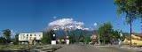
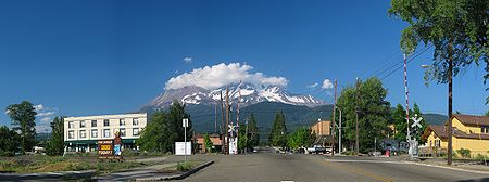
Mount Shasta is a city in Siskiyou County, California
, located at around 3,600 ft (1,100 m) on the flanks of Mount Shasta
, a prominent northern California landmark. The city is less than 9 miles (14.5 km) southwest of the summit of its namesake volcano. As of the 2010 Census the city had a population of 3,394, down from 3,624 at the 2000 census.
area of Northern California
Visitors use Mount Shasta as a base to engage in trout
fishing
in the nearby Sacramento
, McCloud
and Klamath
Rivers, or come to see and climb
Mount Shasta
, Castle Crags or the Trinity Alps
. Visitors also engage in nearby skiing (both alpine
and cross-country
), or bike or hike
to the waterfalls, streams and lakes in the area, including nearby Mossbrae Falls
, Lake Siskiyou
, Castle Lake
and Shasta Lake
.
tribe of Native Americans
. During the 1820s, early Euro-American trappers and hunters first passed through the area, following the path of the Siskiyou Trail
. The Siskiyou Trail was based on a network of ancient Native American footpaths connecting California and the Pacific Northwest. The discovery of gold at nearby Yreka, California
in 1851, dramatically increased traffic along the Siskiyou Trail and through the site of present-day Mount Shasta. Pioneer Ross McCloud
built one of the first lumber mills in the area, near the site of the present Sisson Museum. The completion of a stagecoach road between Yreka and Upper Soda Springs
in the late 1850s led to the building of Sisson's Hotel, as a stop for weary travelers, and as a staging ground for adventuresome tourists intending to climb Mount Shasta.
 The 1887 completion of the Central Pacific Railroad
, built along the line of the Siskiyou Trail, brought a dramatic increase in tourism, lumbering, and population into Mount Shasta. This early development continued to focus on tourism and lumbering. The early 1900s saw the influx of a large number of Italian immigrants to Mount Shasta and neighboring towns, most of whom were employed in the timber industry.
The area where the town later grew up was known first as Strawberry Valley, and then as Berryvale. With the arrival of the railroad, the town was given the name Sisson, California, after prominent land owner Justin Sisson. The name was changed to Mount Shasta City in 1924.
Theosophist Guy Ballard
claimed to have met Saint Germain
while hiking on Mt. Shasta in 1930.
south of Weed
and north of Dunsmuir, California
.
According to the United States Census Bureau
, the city has a total area of 3.8 square miles (9.8 km²), of which, 3.8 square miles (9.8 km²) of it is land and 0.10% of it is covered by water.
The area hydrology consists of an unnamed stream in the south part of town which joins Big Springs Creek, which then flows south as Cold Creek to join the headwaters of the South Fork of the Sacramento River
. The typical depth to groundwater
is quite shallow in the predominant alluvium.
The town is placed on the distal gently sloping southwest flanks of Mount Shasta
, with the chief surficial soils being Quaternary
alluvium
. This alluvium is adjacent to and probably underlain by volcaniclastic rock deposited by Mount Shasta in the course of its development. Groundwater elevation is approximately at the elevation of the underlying native black peat
soil. Where it occurs this peat, of approximately two feet thickness, is underlain by stream deposit sands and gravels.
to the east forces moisture out of the air as it rises and cools, and the dip in the Klamath Mountains
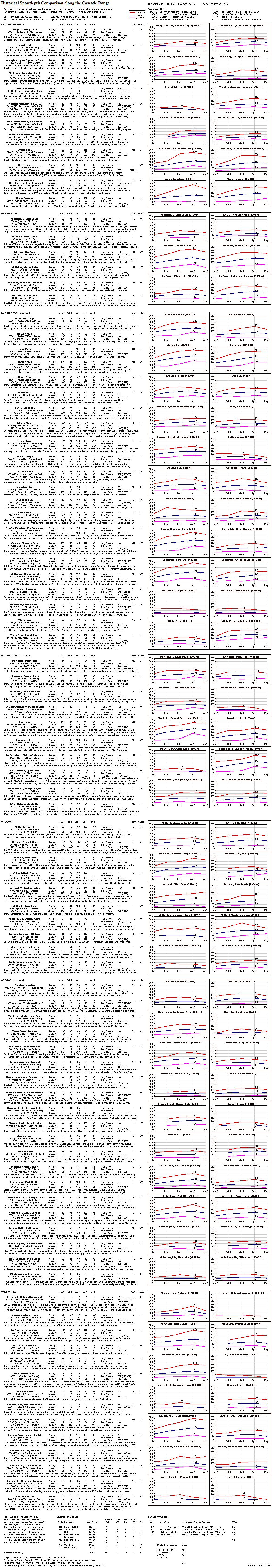
allows more moisture to reach inland, so Mount Shasta receives more precipitation than the semiarid region to the north. This means that in the winter, Mount Shasta gets 104 inches (264.2 cm) of snowfall despite its low 3,600 ft (1,097 m) elevation (http://www.skimountaineer.com/CascadeSki/CascadeSnowSitesInfo.html). In comparison, other towns in the region at similar elevations get much less snow than Mount Shasta, like Weed
, which gets only 20 inches (50.8 cm).(http://skimountaineer.com/CascadeSki/CascadeSnow/SnowdepthComparison.gif).
The record high temperature was 105 °F (40.6 °C) on August 7, 1981, and the record low temperature was -13 F on December 22, 1990. The wettest year was 1998 with 75.15. in and the dryest year was 1976 with 14.27 inches (36.2 cm). The most rainfall in one month was 27.48 inches (69.8 cm) in January 1995, including 5.97 inches (15.2 cm) on January 9. The most snowfall in one year was 349.6 inches (888 cm) in 1952, including 137.7 inches (349.8 cm) in January 1952.
was 900.3 people per square mile (347.6/km²). The racial makeup of Mount Shasta was 3,041 (89.6%) White, 61 (1.8%) African American, 19 (0.6%) Native American, 56 (1.6%) Asian, 2 (0.1%) Pacific Islander, 51 (1.5%) from other races
, and 164 (4.8%) from two or more races. Hispanic or Latino of any race were 277 persons (8.2%).
The Census reported that 3,358 people (98.9% of the population) lived in households, 6 (0.2%) lived in non-institutionalized group quarters, and 30 (0.9%) were institutionalized.
There were 1,664 households, out of which 401 (24.1%) had children under the age of 18 living in them, 537 (32.3%) were opposite-sex married couples
living together, 190 (11.4%) had a female householder with no husband present, 84 (5.0%) had a male householder with no wife present. There were 113 (6.8%) unmarried opposite-sex partnerships
, and 9 (0.5%) same-sex married couples or partnerships. 719 households (43.2%) were made up of individuals and 285 (17.1%) had someone living alone who was 65 years of age or older. The average household size was 2.02. There were 811 families
(48.7% of all households); the average family size was 2.79.
The population was spread out with 692 people (20.4%) under the age of 18, 242 people (7.1%) aged 18 to 24, 732 people (21.6%) aged 25 to 44, 1,109 people (32.7%) aged 45 to 64, and 619 people (18.2%) who were 65 years of age or older. The median age was 45.7 years. For every 100 females there were 84.7 males. For every 100 females age 18 and over, there were 80.6 males.
There were 1,895 housing units at an average density of 502.7 per square mile (194.1/km²), of which 781 (46.9%) were owner-occupied, and 883 (53.1%) were occupied by renters. The homeowner vacancy rate was 2.5%; the rental vacancy rate was 5.8%. 1,699 people (50.1% of the population) lived in owner-occupied housing units and 1,659 people (48.9%) lived in rental housing units.
was 967.5 people per square mile (373.8/km²). There were 1,798 housing units at an average density of 480.4 per square mile (185.6/km²). The racial makeup of the city was 91.77% White, 1.52% Black or African American, 0.44% Native American, 1.63% Asian, 0.14% Pacific Islander, 2.13% from other races, and 2.38% from two or more races. 5.83% of the population were Hispanic or Latino of any race.
There are 1,669 households out of which 27.9% have children under the age of 18 living with them, 38.1% are married couples
living together, 12.3% have a female householder with no husband present, and 44.5% are non-families. 38.0% of all households are made up of individuals and 16.0% have someone living alone who is 65 years of age or older. The average household size is 2.14 and the average family size is 2.83.
In the city the population is spread out with 24.0% under the age of 18, 7.7% from 18 to 24, 24.5% from 25 to 44, 26.4% from 45 to 64, and 17.5% who are 65 years of age or older. The median age is 42 years. For every 100 females there are 87.9 males. For every 100 females age 18 and over, there are 84.5 males.
The median income
for a household in the city is $26,500, and the median income for a family is $37,313. Males have a median income of $37,697 versus $18,708 for females. The per capita income
for the city is $20,629. 19.4% of the population and 14.9% of families are below the poverty line. Out of the total population, 31.5% of those under the age of 18 and 11.2% of those 65 and older are living below the poverty line.
Mount Shasta is located in the 4th Senate
District, represented by Republican
Doug LaMalfa
, and in the 2nd Assembly
District, represented by Republican Jim Nielsen
. Federally, Mount Shasta is located in California's 2nd congressional district
, which has a Cook PVI
of R +13 and is represented by Republican Wally Herger
.
Siskiyou County, California
Siskiyou County is a county located in the far northernmost part of the U.S. state of California, in the Shasta Cascade region on the Oregon border. Yreka is the county seat. Because of its substantial natural beauty, outdoor recreation opportunities, and Gold Rush era history, it is an important...
, located at around 3,600 ft (1,100 m) on the flanks of Mount Shasta
Mount Shasta
Mount Shasta is located at the southern end of the Cascade Range in Siskiyou County, California and at is the second highest peak in the Cascades and the fifth highest in California...
, a prominent northern California landmark. The city is less than 9 miles (14.5 km) southwest of the summit of its namesake volcano. As of the 2010 Census the city had a population of 3,394, down from 3,624 at the 2000 census.
Commerce and tourism
Located in the Shasta CascadeShasta Cascade
The Shasta Cascade region of California is located in the northeastern and north-central sections of the state bordering Oregon and Nevada, including far northern parts of the Central Valley and the Sierra Nevada mountain range. The area is centered on Mount Shasta in the California Cascade Range,...
area of Northern California
Northern California
Northern California is the northern portion of the U.S. state of California. The San Francisco Bay Area , and Sacramento as well as its metropolitan area are the main population centers...
Visitors use Mount Shasta as a base to engage in trout
Trout
Trout is the name for a number of species of freshwater and saltwater fish belonging to the Salmoninae subfamily of the family Salmonidae. Salmon belong to the same family as trout. Most salmon species spend almost all their lives in salt water...
fishing
Fishing
Fishing is the activity of trying to catch wild fish. Fish are normally caught in the wild. Techniques for catching fish include hand gathering, spearing, netting, angling and trapping....
in the nearby Sacramento
Sacramento River
The Sacramento River is an important watercourse of Northern and Central California in the United States. The largest river in California, it rises on the eastern slopes of the Klamath Mountains, and after a journey south of over , empties into Suisun Bay, an arm of the San Francisco Bay, and...
, McCloud
McCloud River
The McCloud River is a river that flows east of and parallel to the Sacramento River, long, in northern California in the United States. It drains a scenic mountainous area of the Cascade Range north of Redding...
and Klamath
Klamath River
The Klamath River is an American river that flows southwest through Oregon and northern California, cutting through the Cascade Range to empty into the Pacific Ocean. The river drains an extensive watershed of almost that stretches from the high desert country of the Great Basin to the temperate...
Rivers, or come to see and climb
Mountaineering
Mountaineering or mountain climbing is the sport, hobby or profession of hiking, skiing, and climbing mountains. While mountaineering began as attempts to reach the highest point of unclimbed mountains it has branched into specialisations that address different aspects of the mountain and consists...
Mount Shasta
Mount Shasta
Mount Shasta is located at the southern end of the Cascade Range in Siskiyou County, California and at is the second highest peak in the Cascades and the fifth highest in California...
, Castle Crags or the Trinity Alps
Trinity Alps
The Trinity Alps are mountains in Northern California, in the Pacific Coast Ranges physiographic region, located to the northwest of Redding. Elevations there range from to at Thompson Peak. The Trinity Alps Wilderness covers , making it the second largest wilderness area in California...
. Visitors also engage in nearby skiing (both alpine
Alpine skiing
Alpine skiing is the sport of sliding down snow-covered hills on skis with fixed-heel bindings. Alpine skiing can be contrasted with skiing using free-heel bindings: Ski mountaineering and nordic skiing – such as cross-country; ski jumping; and Telemark. In competitive alpine skiing races four...
and cross-country
Nordic skiing
Nordic skiing is a winter sport that encompasses all types of skiing where the heel of the boot cannot be fixed to the ski, as opposed to Alpine skiing....
), or bike or hike
Hiking
Hiking is an outdoor activity which consists of walking in natural environments, often in mountainous or other scenic terrain. People often hike on hiking trails. It is such a popular activity that there are numerous hiking organizations worldwide. The health benefits of different types of hiking...
to the waterfalls, streams and lakes in the area, including nearby Mossbrae Falls
Mossbrae Falls
Mossbrae Falls is a waterfall flowing into the Sacramento River, in the Shasta Cascade area in Dunsmuir, California. The falls are accessible via a mile-long hiking trail along the Union Pacific Railroad, which begins at the Shasta Retreat on Scarlett Way in Dunsmuir. Mossbrae Falls is one...
, Lake Siskiyou
Lake Siskiyou
Lake Siskiyou is a reservoir formed by Box Canyon Dam on the Sacramento River, in far northern California, near the town of Mount Shasta, California. It is the site of local recreation, as well as being used for watershed protection and flood control....
, Castle Lake
Castle Lake (California)
Castle Lake is a glacial lake located in northern California along the eastern edge of the Klamath Mountains, in Siskiyou County, near the city of Mount Shasta. The outlet of the lake drains into Castle Lake Creek, and then into Lake Siskiyou; the lake is part of the headwaters of the Sacramento...
and Shasta Lake
Shasta Lake
Shasta Lake, also called Lake Shasta, is an artificial lake created by the construction of Shasta Dam across the Sacramento River in the Shasta-Trinity National Forest of Shasta County, California...
.
History
The site of present-day Mount Shasta City was within the range of the OkwanuchuOkwanuchu
The Okwanuchu were one of a number of small Shastan-speaking tribes of Native Americans in Northern California, who were closely related to the adjacent larger Shasta tribe...
tribe of Native Americans
Native Americans in the United States
Native Americans in the United States are the indigenous peoples in North America within the boundaries of the present-day continental United States, parts of Alaska, and the island state of Hawaii. They are composed of numerous, distinct tribes, states, and ethnic groups, many of which survive as...
. During the 1820s, early Euro-American trappers and hunters first passed through the area, following the path of the Siskiyou Trail
Siskiyou Trail
The Siskiyou Trail stretched from California's Central Valley to Oregon's Willamette Valley; modern-day Interstate 5 follows this pioneer path...
. The Siskiyou Trail was based on a network of ancient Native American footpaths connecting California and the Pacific Northwest. The discovery of gold at nearby Yreka, California
Yreka, California
Yreka is the county seat of Siskiyou County, California, United States. The population was 7,765 at the 2010 census, up from 7,290 at the 2000 census.- History:...
in 1851, dramatically increased traffic along the Siskiyou Trail and through the site of present-day Mount Shasta. Pioneer Ross McCloud
Ross McCloud
Ross McCloud was a California pioneer and early settler in Northern California. While he is regarded by some as a namesake of the town of McCloud, California, and the nearby McCloud River, please see historical note below.Born and raised in Ohio, McCloud moved to Iowa when he was a young man,...
built one of the first lumber mills in the area, near the site of the present Sisson Museum. The completion of a stagecoach road between Yreka and Upper Soda Springs
Upper Soda Springs
Upper Soda Springs is on the banks of the Sacramento River in Dunsmuir, California, USA. It consists of approximately ten acres of level ground on both sides of the River, the surrounding hillsides, and continues north along the eastern bank of the Sacramento River to the Dunsmuir City Park...
in the late 1850s led to the building of Sisson's Hotel, as a stop for weary travelers, and as a staging ground for adventuresome tourists intending to climb Mount Shasta.
Central Pacific Railroad
The Central Pacific Railroad is the former name of the railroad network built between California and Utah, USA that formed part of the "First Transcontinental Railroad" in North America. It is now part of the Union Pacific Railroad. Many 19th century national proposals to build a transcontinental...
, built along the line of the Siskiyou Trail, brought a dramatic increase in tourism, lumbering, and population into Mount Shasta. This early development continued to focus on tourism and lumbering. The early 1900s saw the influx of a large number of Italian immigrants to Mount Shasta and neighboring towns, most of whom were employed in the timber industry.
The area where the town later grew up was known first as Strawberry Valley, and then as Berryvale. With the arrival of the railroad, the town was given the name Sisson, California, after prominent land owner Justin Sisson. The name was changed to Mount Shasta City in 1924.
Theosophist Guy Ballard
Guy Ballard
Guy Warren Ballard was an American mining engineer who became, with his wife, Edna Anne Wheeler Ballard, the founder of the "I AM" Activity....
claimed to have met Saint Germain
Germain of Paris
Saint Germain was a bishop of Paris, who was canonized in 754. He is known in his early vita as pater et pastor populi, rendered in modern times as the "Father of the Poor".-Biography:...
while hiking on Mt. Shasta in 1930.
Geography
Mount Shasta is located at 41°18'52" North, 122°18'41" West (41.314542, -122.311510). It is located along Interstate 5Interstate 5
Interstate 5 is the main Interstate Highway on the West Coast of the United States, running largely parallel to the Pacific Ocean coastline from Canada to Mexico . It serves some of the largest cities on the U.S...
south of Weed
Weed, California
Weed is a city located in Siskiyou County, California. As of the 2010 Census, the town had a total population of 2,967, down from 2,979 at the 2000 census. There are several unincorporated communities adjacent to, or just outside Weed proper. These include Edgewood, Carrick, Lake Shastina, Rancho...
and north of Dunsmuir, California
Dunsmuir, California
Dunsmuir is a city in Siskiyou County, California, United States. The population was 1,650 at the 2010 census, down from 1,923 at the 2000 census. It is currently a hub of tourism in Northern California as visitors enjoy fishing, skiing, climbing, or sight-seeing...
.
According to the United States Census Bureau
United States Census Bureau
The United States Census Bureau is the government agency that is responsible for the United States Census. It also gathers other national demographic and economic data...
, the city has a total area of 3.8 square miles (9.8 km²), of which, 3.8 square miles (9.8 km²) of it is land and 0.10% of it is covered by water.
The area hydrology consists of an unnamed stream in the south part of town which joins Big Springs Creek, which then flows south as Cold Creek to join the headwaters of the South Fork of the Sacramento River
Sacramento River
The Sacramento River is an important watercourse of Northern and Central California in the United States. The largest river in California, it rises on the eastern slopes of the Klamath Mountains, and after a journey south of over , empties into Suisun Bay, an arm of the San Francisco Bay, and...
. The typical depth to groundwater
Groundwater
Groundwater is water located beneath the ground surface in soil pore spaces and in the fractures of rock formations. A unit of rock or an unconsolidated deposit is called an aquifer when it can yield a usable quantity of water. The depth at which soil pore spaces or fractures and voids in rock...
is quite shallow in the predominant alluvium.
The town is placed on the distal gently sloping southwest flanks of Mount Shasta
Mount Shasta
Mount Shasta is located at the southern end of the Cascade Range in Siskiyou County, California and at is the second highest peak in the Cascades and the fifth highest in California...
, with the chief surficial soils being Quaternary
Quaternary
The Quaternary Period is the most recent of the three periods of the Cenozoic Era in the geologic time scale of the ICS. It follows the Neogene Period, spanning 2.588 ± 0.005 million years ago to the present...
alluvium
Alluvium
Alluvium is loose, unconsolidated soil or sediments, eroded, deposited, and reshaped by water in some form in a non-marine setting. Alluvium is typically made up of a variety of materials, including fine particles of silt and clay and larger particles of sand and gravel...
. This alluvium is adjacent to and probably underlain by volcaniclastic rock deposited by Mount Shasta in the course of its development. Groundwater elevation is approximately at the elevation of the underlying native black peat
Peat
Peat is an accumulation of partially decayed vegetation matter or histosol. Peat forms in wetland bogs, moors, muskegs, pocosins, mires, and peat swamp forests. Peat is harvested as an important source of fuel in certain parts of the world...
soil. Where it occurs this peat, of approximately two feet thickness, is underlain by stream deposit sands and gravels.
Climate
Mount ShastaMount Shasta
Mount Shasta is located at the southern end of the Cascade Range in Siskiyou County, California and at is the second highest peak in the Cascades and the fifth highest in California...
to the east forces moisture out of the air as it rises and cools, and the dip in the Klamath Mountains
Klamath Mountains
The Klamath Mountains, which include the Siskiyou, Marble, Scott, Trinity, Trinity Alps, Salmon, and northern Yolla-Bolly Mountains, are a rugged lightly populated mountain range in northwest California and southwest Oregon in the United States...
allows more moisture to reach inland, so Mount Shasta receives more precipitation than the semiarid region to the north. This means that in the winter, Mount Shasta gets 104 inches (264.2 cm) of snowfall despite its low 3,600 ft (1,097 m) elevation (http://www.skimountaineer.com/CascadeSki/CascadeSnowSitesInfo.html). In comparison, other towns in the region at similar elevations get much less snow than Mount Shasta, like Weed
Weed, California
Weed is a city located in Siskiyou County, California. As of the 2010 Census, the town had a total population of 2,967, down from 2,979 at the 2000 census. There are several unincorporated communities adjacent to, or just outside Weed proper. These include Edgewood, Carrick, Lake Shastina, Rancho...
, which gets only 20 inches (50.8 cm).(http://skimountaineer.com/CascadeSki/CascadeSnow/SnowdepthComparison.gif).
The record high temperature was 105 °F (40.6 °C) on August 7, 1981, and the record low temperature was -13 F on December 22, 1990. The wettest year was 1998 with 75.15. in and the dryest year was 1976 with 14.27 inches (36.2 cm). The most rainfall in one month was 27.48 inches (69.8 cm) in January 1995, including 5.97 inches (15.2 cm) on January 9. The most snowfall in one year was 349.6 inches (888 cm) in 1952, including 137.7 inches (349.8 cm) in January 1952.
| Monthly Normal and Record High and Low Temperatures | ||||||||||||
| Month | Jan | Feb | Mar | Apr | May | Jun | Jul | Aug | Sep | Oct | Nov | Dec |
|---|---|---|---|---|---|---|---|---|---|---|---|---|
| Rec High °F | 65 | 71 | 80 | 86 | 94 | 98 | 100 | 105 | 103 | 93 | 80 | 72 |
| Norm High °F | 44.2 | 47.6 | 52.1 | 59.2 | 67.3 | 75.5 | 83.2 | 82.6 | 76 | 64.4 | 49.9 | 43.8 |
| Norm Low °F | 26.4 | 28.7 | 30.3 | 33.3 | 39 | 44.9 | 48.9 | 47.5 | 42.9 | 36.6 | 29.9 | 25.8 |
| Rec Low °F | -13 | 1 | 11 | 14 | 21 | 25 | 31 | 34 | 25 | 19 | 9 | -5 |
| Precip (in) | 7.06 | 6.45 | 5.81 | 2.65 | 1.87 | 0.99 | 0.39 | 0.43 | 0.87 | 2.21 | 5.08 | 5.35 |
| Source: USTravelWeather.com http://www.ustravelweather.com/weather-california/mount-shasta-weather.asp | ||||||||||||
2010
The 2010 United States Census reported that Mount Shasta had a population of 3,394. The population densityPopulation density
Population density is a measurement of population per unit area or unit volume. It is frequently applied to living organisms, and particularly to humans...
was 900.3 people per square mile (347.6/km²). The racial makeup of Mount Shasta was 3,041 (89.6%) White, 61 (1.8%) African American, 19 (0.6%) Native American, 56 (1.6%) Asian, 2 (0.1%) Pacific Islander, 51 (1.5%) from other races
Race (United States Census)
Race and ethnicity in the United States Census, as defined by the Federal Office of Management and Budget and the United States Census Bureau, are self-identification data items in which residents choose the race or races with which they most closely identify, and indicate whether or not they are...
, and 164 (4.8%) from two or more races. Hispanic or Latino of any race were 277 persons (8.2%).
The Census reported that 3,358 people (98.9% of the population) lived in households, 6 (0.2%) lived in non-institutionalized group quarters, and 30 (0.9%) were institutionalized.
There were 1,664 households, out of which 401 (24.1%) had children under the age of 18 living in them, 537 (32.3%) were opposite-sex married couples
Marriage
Marriage is a social union or legal contract between people that creates kinship. It is an institution in which interpersonal relationships, usually intimate and sexual, are acknowledged in a variety of ways, depending on the culture or subculture in which it is found...
living together, 190 (11.4%) had a female householder with no husband present, 84 (5.0%) had a male householder with no wife present. There were 113 (6.8%) unmarried opposite-sex partnerships
POSSLQ
POSSLQ is an abbreviation for "Persons of Opposite Sex Sharing Living Quarters," a term coined in the late 1970s by the United States Census Bureau as part of an effort to more accurately gauge the prevalence of cohabitation in American households....
, and 9 (0.5%) same-sex married couples or partnerships. 719 households (43.2%) were made up of individuals and 285 (17.1%) had someone living alone who was 65 years of age or older. The average household size was 2.02. There were 811 families
Family (U.S. Census)
A family or family household is defined by the United States Census Bureau for statistical purposes as "a householder and one or more other people related to the householder by birth, marriage, or adoption. They do not include same-sex married couples even if the marriage was performed in a state...
(48.7% of all households); the average family size was 2.79.
The population was spread out with 692 people (20.4%) under the age of 18, 242 people (7.1%) aged 18 to 24, 732 people (21.6%) aged 25 to 44, 1,109 people (32.7%) aged 45 to 64, and 619 people (18.2%) who were 65 years of age or older. The median age was 45.7 years. For every 100 females there were 84.7 males. For every 100 females age 18 and over, there were 80.6 males.
There were 1,895 housing units at an average density of 502.7 per square mile (194.1/km²), of which 781 (46.9%) were owner-occupied, and 883 (53.1%) were occupied by renters. The homeowner vacancy rate was 2.5%; the rental vacancy rate was 5.8%. 1,699 people (50.1% of the population) lived in owner-occupied housing units and 1,659 people (48.9%) lived in rental housing units.
2000
As of the census of 2000, there were 3,621 people, 1,669 households, and 926 families residing in the city. The population densityPopulation density
Population density is a measurement of population per unit area or unit volume. It is frequently applied to living organisms, and particularly to humans...
was 967.5 people per square mile (373.8/km²). There were 1,798 housing units at an average density of 480.4 per square mile (185.6/km²). The racial makeup of the city was 91.77% White, 1.52% Black or African American, 0.44% Native American, 1.63% Asian, 0.14% Pacific Islander, 2.13% from other races, and 2.38% from two or more races. 5.83% of the population were Hispanic or Latino of any race.
There are 1,669 households out of which 27.9% have children under the age of 18 living with them, 38.1% are married couples
Marriage
Marriage is a social union or legal contract between people that creates kinship. It is an institution in which interpersonal relationships, usually intimate and sexual, are acknowledged in a variety of ways, depending on the culture or subculture in which it is found...
living together, 12.3% have a female householder with no husband present, and 44.5% are non-families. 38.0% of all households are made up of individuals and 16.0% have someone living alone who is 65 years of age or older. The average household size is 2.14 and the average family size is 2.83.
In the city the population is spread out with 24.0% under the age of 18, 7.7% from 18 to 24, 24.5% from 25 to 44, 26.4% from 45 to 64, and 17.5% who are 65 years of age or older. The median age is 42 years. For every 100 females there are 87.9 males. For every 100 females age 18 and over, there are 84.5 males.
The median income
Income
Income is the consumption and savings opportunity gained by an entity within a specified time frame, which is generally expressed in monetary terms. However, for households and individuals, "income is the sum of all the wages, salaries, profits, interests payments, rents and other forms of earnings...
for a household in the city is $26,500, and the median income for a family is $37,313. Males have a median income of $37,697 versus $18,708 for females. The per capita income
Per capita income
Per capita income or income per person is a measure of mean income within an economic aggregate, such as a country or city. It is calculated by taking a measure of all sources of income in the aggregate and dividing it by the total population...
for the city is $20,629. 19.4% of the population and 14.9% of families are below the poverty line. Out of the total population, 31.5% of those under the age of 18 and 11.2% of those 65 and older are living below the poverty line.
Politics
In the state legislatureCalifornia State Legislature
The California State Legislature is the state legislature of the U.S. state of California. It is a bicameral body consisting of the lower house, the California State Assembly, with 80 members, and the upper house, the California State Senate, with 40 members...
Mount Shasta is located in the 4th Senate
California State Senate
The California State Senate is the upper house of the California State Legislature. There are 40 state senators. The state legislature meets in the California State Capitol in Sacramento. The Lieutenant Governor is the ex officio President of the Senate and may break a tied vote...
District, represented by Republican
Republican Party (United States)
The Republican Party is one of the two major contemporary political parties in the United States, along with the Democratic Party. Founded by anti-slavery expansion activists in 1854, it is often called the GOP . The party's platform generally reflects American conservatism in the U.S...
Doug LaMalfa
Doug LaMalfa
Doug LaMalfa is an American politician currently serving in the California State Senate. He is a Republican representing the 4th district, encompassing Del Norte, Siskiyou, Shasta, Trinity, Tehama, Butte, Glenn, Colusa, Sutter, and Yuba counties, as well as parts of Nevada and Placer counties...
, and in the 2nd Assembly
California State Assembly
The California State Assembly is the lower house of the California State Legislature. There are 80 members in the Assembly, representing an approximately equal number of constituents, with each district having a population of at least 420,000...
District, represented by Republican Jim Nielsen
Jim Nielsen
James Wiley Nielsen is an American politician from California and a member of the Republican party. Nielsen served on the Yolo County Republican Committee before winning election to the California State Senate in 1978...
. Federally, Mount Shasta is located in California's 2nd congressional district
California's 2nd congressional district
California's 2nd congressional district is a congressional district located in the U.S. state of California. The district contains much of the far northern part of the state, north of Sacramento. It is the largest district by area in California...
, which has a Cook PVI
Cook Partisan Voting Index
The Cook Partisan Voting Index , sometimes referred to as simply the Partisan Voting Index , is a measurement of how strongly an American congressional district or state leans toward one political party compared to the nation as a whole...
of R +13 and is represented by Republican Wally Herger
Wally Herger
Walter William "Wally" Herger, Jr. , American politician, has been a Republican member of the United States House of Representatives since 1987, representing the California's 2nd congressional district. The second district is physically large...
.
Notable residents
- Former NFL defensive star Jason SehornJason SehornJason Heath Sehorn is a former professional American football defensive back in the National Football League.-Early years:Sehorn was born in Sacramento, California...
is a 1989 graduate of Mount Shasta High School. - Writer Anita LoosAnita LoosAnita Loos was an American screenwriter, playwright and author.-Early life:Born Corinne Anita Loos in Sisson, California , where her father, R. Beers Loos, had opened a tabloid newspaper for which her mother, Minerva "Minnie" Smith did most of the work of a newspaper publisher...
, author of the screenplay Gentlemen Prefer Blondes, was born in Sisson (now Mount Shasta) in 1888. - Sherrie Russell Meline, the artist whose painting of a Ross's GooseRoss's GooseThe Ross's Goose is a North American species of goose.The American Ornithologists' Union places this species and the other two "white" geese in the genus Chen rather than the more traditional "grey" goose genus Anser.This goose breeds in northern Canada, mainly in the Queen Maud Gulf Migratory...
was selected for the 2006-2007 Federal Duck StampFederal Duck StampThe federal duck stamp was created through a wetlands conservation program. President Herbert Hoover signed the Migratory Bird Conservation Act in 1929 to authorize the acquisition and preservation of wetlands as waterfowl habitat....
, lives in Mount Shasta.
See also
- Mount ShastaMount ShastaMount Shasta is located at the southern end of the Cascade Range in Siskiyou County, California and at is the second highest peak in the Cascades and the fifth highest in California...
- Mount Shasta Ski ParkMount Shasta Ski ParkMount Shasta Ski Park is a ski resort located in northern California, just east of Interstate 5 along SR 89 between the city of Mount Shasta and the town of McCloud. The ski area lies about south of the summit of Mount Shasta, the second highest volcano in the Cascade Range...
- Shasta AbbeyShasta AbbeyShasta Abbey is a Zen Buddhist Monastery, established in 1970 by Houn Jiyu-Kennett in Mount Shasta, California, in the United States. It is a training monastery, and is open to visitors who want to learn about Buddhism....
- Shasta LakeShasta LakeShasta Lake, also called Lake Shasta, is an artificial lake created by the construction of Shasta Dam across the Sacramento River in the Shasta-Trinity National Forest of Shasta County, California...
- McCloud RailwayMcCloud RailwayThe McCloud Railway is a class III railroad operated around Mount Shasta, California. It began operations on July 1, 1992 when it took over operations from the McCloud River Railroad...