

Dunsmuir, California
Encyclopedia
Dunsmuir is a city in Siskiyou County
, California
, United States
. The population was 1,650 at the 2010 census, down from 1,923 at the 2000 census. It is currently a hub of tourism in Northern California
as visitors enjoy fishing, skiing, climbing, or sight-seeing. During steam engine days, it was notable for being the site of an important Central Pacific
(and later Southern Pacific
) railroad yard, where extra steam locomotive
s were added to assist trains on the grade to the north.
area of Northern California
, Dunsmuir is a popular destination for tourists. Visitors come to trout fish in the Sacramento
and McCloud
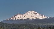
Rivers, or to see and climb Mount Shasta
, Castle Crags
or the Trinity Alps
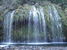
. Visitors ski (both alpine and cross-country) and bicycle, or can hike to the waterfalls, streams and lakes in the area, including nearby Mossbrae Falls
, Lake Siskiyou
, Castle Lake
and Shasta Lake
.
The town is also a destination for historical and cultural tourists, as the town has preserved an authentic 1920s and 1930s look and feel. Dunsmuir's long connection with the railroad draws railfans to enjoy the sights and sounds of the railroad in the steep Sacramento River canyon. Fly fishing is allowed all year round in town (catch and release in Winter) and skiing is close by at Mount Shasta Ski Park.
Dunsmuir has frequent events that draw people from far and wide. In 2010 local concerts featured Charlie Musselwhite, the Palo Alto Chamber Orchestra and Janis Joplin's original band, Big Brother & The Holding company, the later held in the City Ball Park where Babe Ruth and some of the Yankee's played with the local boys. Regular musical entertainment is regularly featured at the new Dunsmuir Brewery Works & Pub and several other local venues, and at local weekend festivals including a celebration of the City's official tree, Dogwood Daze as well as Railroad Days and the Tribute to the Trees concert held al fresco along the river in the City's pristine park, The Dunsmuir Botanical Gardens.
 Sites in and near Dunsmuir have been inhabited for over 5000 years. At least three waves of early peoples swept through area, establishing residence. At the time of the first European-American contact in the 1820s, the site of Dunsmuir was within the range of the Okwanuchu
tribe of Native Americans
.
During the 1820s, early European-American hunters and trappers passed through Dunsmuir's site, following the Siskiyou Trail
. In the mid-1830s, pioneer horse and cattle drives came up the Sacramento Canyon, delivering livestock from Mexican California to the new settlements in the Oregon Country
to the north. In 1841, an overland party of the famous United States Exploring Expedition
passed through the area.
The California Gold Rush
led to increased traffic along the Siskiyou Trail through Dunsmuir's site, leading to the first non-Native American settlers at Upper Soda Springs
in north Dunsmuir in the early 1850s. The discovery of gold at Yreka, California
dramatically increased movement through the site of Dunsmuir, and a toll bridge and stagecoach hotel were built at Upper Soda Springs.
In 1887, the completion of the Central Pacific Railroad
along the line of the Siskiyou Trail led to the creation of the modern town of Dunsmuir. The railroad developed a division point on the flats south of Upper Soda Springs, where railroad steam engines would be serviced, and added to trains to push them up the steep grades north of town. A roundhouse and turntable were built. All this activity required the creation of a town, initially known as 'Poverty Flats' or 'Pusher'. South of the present downtown and north of Castella is an area known as Nutglade, which was previously known as Dunsmuir and before that, Cedar Flat. So the name moved north from the South rail yard to the main rail yard. During the railroad heyday, Dunsmuir was the largest town in this County which is the size of Delaware and Rhode Island combined.
In 1888, British Columbian coal baron Alexander Dunsmuir was passing through the little development, and according to contemporary accounts, was so taken with the beauty of the area that he offered to donate a fountain to the new town, if they would name the town in his honor. The offer was accepted, and Dunsmuir's fountain remains operational near the City Park.
By the early 1900s, Dunsmuir was the largest town in Siskiyou County, and for a long time had been the largest California city north of Sacramento. The construction of the Pacific Highway along the Siskiyou Trail in the mid-1910s brought more tourists. By the mid-1950s, the railroad transitioned from steam to diesel locomotives, and the substantial workforce in Dunsmuir was not needed, resulting in the town's contraction.
As a result, Dunsmuir retains today much of the charm and scale of the 1920s and 1930s, and has been designated on the National Register of Historic Places
. The downtown area is now a designated historic district. The painted signage is remarkable.
In July 1935, two fugitives were passing through town. Police Chief F.R. "Jack" Daw, and California Highway Patrol Officer C. "Doc" Malone went to catch them. The criminals ambushed the officers wounding Officer Malone and killing Chief Daw. One of the criminals, Clyde Johnson, was caught and put in jail in Yreka to await trial. A group of vigilantes from Dunsmuir went to Yreka, broke Johnson out of jail and lynched him. To this day the identity of those vigilantes has never been formally acknowledged. It is said to have been the last public lynching in California.
On the night of July 14, 1991, a derailment on a horseshoe curve
known as the "Cantara Loop" on the railroad north of Dunsmuir (then owned by the Southern Pacific Railroad) resulted in the release of approximately 19,000 gallons of metam sodium spilled into the Sacramento River
. The biocide killed every living thing in the river for a distance of some 38 miles (61.2 km), devastating a popular fly fishing
area—one of the most severe toxic spills in U.S. history.
The Upper Sacramento River is now largely recovered from the spill though some species (crayfish and frogs) have not yet come back. The watershed is carefully stewarded by The Upper Sacramento River Exchange. The once-popular fishery is again healthy. Recent changes to angling regulations have opened the Upper Sacramento River to catch-and-release fishing all year round. Five pound trout have often been caught right in the City.
(about ninety miles north in the state of Oregon
). There are an average of 54.3 days with highs of 90 °F (32.2 °C) or higher and an average of 99.7 days with lows of 32 °F (0 °C) or lower. The record high was 109 °F (42.8 °C) on August 8, 1981, and the record low was 4 °F (-15.6 °C) on December 21, 1990.
The average annual precipitation is 63.31 inches (160.8 cm). There are an average of 98 days with measurable precipitation. The wettest year was 1983 with 117.47 inches (298.4 cm) and the dryest year was 1976 with 23.72 inches (60.2 cm). The most rainfall in one month was 39.2 inches (99.6 cm) in January 1995. The most rainfall in 24 hours was 6.44 inches (16.4 cm) on January 1, 1997. Snowfall averages 29.2 inches (74.2 cm). The most snowfall in one year was 226.6 inches (575.6 cm) in 1952, including 119.5 inches (303.5 cm) in January 1952.
According to the United States Census Bureau
, the city has a total area of 1.7 mi2, 97.86% of it land and 2.14% of it water.
The City is the site of the historic park being developed at Upper Soda Springs
on the path of the Siskiyou Trail
along the Sacramento River
.
At an elevation of approximately 2350 feet (716.3 m) above sea level, a unique setting is created by the Sacramento River in which class 3 whitewater rapids are usually created during summer run off through a town of about 2,000 residents. In plain view from some of the city's public streets, this may be one of the few places in western North America where three categories of "twos" (population, elevation, and whitewater difficulty) are met or eclipsed. (Eastern US example-The Cherry River at Richwood, WV)
Mt. Shasta's caverns filter the drinking water and eliminate the need for filtration or treatment thus the town's marketing slogan, "Home Of The Best Water On Earth"℠. Three water fountains are located on Dunsmuir Avenue in the Historic District. Two of them run 24 hours a day.
Elevation: 2347 feet (715.4 m)
was 951.0 people per square mile (367.2/km²). The racial makeup of Dunsmuir was 1,443 (87.5%) White, 32 (1.9%) African American, 17 (1.0%) Native American, 15 (0.9%) Asian, 4 (0.2%) Pacific Islander, 30 (1.8%) from other races
, and 109 (6.6%) from two or more races. Hispanic or Latino of any race were 167 persons (10.1%).
The Census reported that 1,650 people (100% of the population) lived in households, 0 (0%) lived in non-institutionalized group quarters, and 0 (0%) were institutionalized.
There were 763 households, out of which 180 (23.6%) had children under the age of 18 living in them, 276 (36.2%) were opposite-sex married couples
living together, 84 (11.0%) had a female householder with no husband present, 51 (6.7%) had a male householder with no wife present. There were 80 (10.5%) unmarried opposite-sex partnerships
, and 6 (0.8%) same-sex married couples or partnerships. 271 households (35.5%) were made up of individuals and 99 (13.0%) had someone living alone who was 65 years of age or older. The average household size was 2.16. There were 411 families
(53.9% of all households); the average family size was 2.77.
The population was spread out with 320 people (19.4%) under the age of 18, 110 people (6.7%) aged 18 to 24, 354 people (21.5%) aged 25 to 44, 584 people (35.4%) aged 45 to 64, and 282 people (17.1%) who were 65 years of age or older. The median age was 47.0 years. For every 100 females there were 105.7 males. For every 100 females age 18 and over, there were 101.2 males.
There were 1,110 housing units at an average density of 639.8 per square mile (247.0/km²), of which 416 (54.5%) were owner-occupied, and 347 (45.5%) were occupied by renters. The homeowner vacancy rate was 2.8%; the rental vacancy rate was 15.6%. 886 people (53.7% of the population) lived in owner-occupied housing units and 764 people (46.3%) lived in rental housing units.
of 2000, there were 1,923 people, 867 households, and 491 families residing in the city. The population density
was 1,062.1 people per square mile (410.2/km²). There were 1,170 housing units at an average density of 646.2 per square mile (249.6/km²). The racial makeup of the city was 90.64% White, 1.87% African American, 1.98% Native American, 0.52% Asian, 0.05% Pacific Islander, 2.34% from other races
, and 2.60% from two or more races. Hispanic or Latino of any race were 9.93% of the population.
There were 867 households out of which 23.6% had children under the age of 18 living with them, 43.1% were married couples
living together, 10.3% had a female householder with no husband present, and 43.3% were non-families. 35.4% of all households were made up of individuals and 16.4% had someone living alone who was 65 years of age or older. The average household size was 2.22 and the average family size was 2.84.
In the city the population was spread out with 22.4% under the age of 18, 6.8% from 18 to 24, 23.2% from 25 to 44, 28.8% from 45 to 64, and 18.8% who were 65 years of age or older. The median age was 44 years. For every 100 females there were 97.6 males. For every 100 females age 18 and over, there were 98.3 males.
The median income
for a household in the city was $23,191, and the median income for a family was $27,420. Males had a median income of $27,393 versus $19,148 for females. The per capita income
for the city was $15,982. About 13.4% of families and 19.3% of the population were below the poverty line, including 23.7% of those under age 18 and 3.2% of those age 65 or over.
Dunsmuir is located in the 4th Senate
District, represented by Republican
Doug LaMalfa
, and in the 2nd Assembly
District, represented by Republican Jim Nielsen
. Federally, Dunsmuir is located in California's 2nd congressional district
, which has a Cook PVI
of R +13 and is semi-represented by Republican Wally Herger
.
Dunsmuir has a City Manager form of government with an elected 5 person Council, a Chamber of Commerce and two school districts.
The current Mayor is Nick Mitchell.
's Coast Starlight
stops daily in both directions at the Dunsmuir Amtrak station
, located on one of Dunsmuir's two commercial streets, both in the historic district. The County bus service "The Stage" from Dunsmuir north through the County (Mt. Shasta, Weed, Yreka, etc.) connects to Amtrak. The Amtrak station is well maintained by city residents and local rail enthusiasts, boasting a nice museum and a clean modern station with telephones, bathrooms, and pleasant respite from the weather. The town itself is a railroad museum with an operating turntable. Dunsmuir is the only station stop in Siskiyou County, located at a midpoint between Redding, CA and Klamath Falls, OR, and is the northern most Amtrak station in California.
Siskiyou County, California
Siskiyou County is a county located in the far northernmost part of the U.S. state of California, in the Shasta Cascade region on the Oregon border. Yreka is the county seat. Because of its substantial natural beauty, outdoor recreation opportunities, and Gold Rush era history, it is an important...
, California
California
California is a state located on the West Coast of the United States. It is by far the most populous U.S. state, and the third-largest by land area...
, United States
United States
The United States of America is a federal constitutional republic comprising fifty states and a federal district...
. The population was 1,650 at the 2010 census, down from 1,923 at the 2000 census. It is currently a hub of tourism in Northern California
Northern California
Northern California is the northern portion of the U.S. state of California. The San Francisco Bay Area , and Sacramento as well as its metropolitan area are the main population centers...
as visitors enjoy fishing, skiing, climbing, or sight-seeing. During steam engine days, it was notable for being the site of an important Central Pacific
Central Pacific Railroad
The Central Pacific Railroad is the former name of the railroad network built between California and Utah, USA that formed part of the "First Transcontinental Railroad" in North America. It is now part of the Union Pacific Railroad. Many 19th century national proposals to build a transcontinental...
(and later Southern Pacific
Southern Pacific Railroad
The Southern Pacific Transportation Company , earlier Southern Pacific Railroad and Southern Pacific Company, and usually simply called the Southern Pacific or Espee, was an American railroad....
) railroad yard, where extra steam locomotive
Steam locomotive
A steam locomotive is a railway locomotive that produces its power through a steam engine. These locomotives are fueled by burning some combustible material, usually coal, wood or oil, to produce steam in a boiler, which drives the steam engine...
s were added to assist trains on the grade to the north.
Commerce and tourism
Located in the Shasta CascadeShasta Cascade
The Shasta Cascade region of California is located in the northeastern and north-central sections of the state bordering Oregon and Nevada, including far northern parts of the Central Valley and the Sierra Nevada mountain range. The area is centered on Mount Shasta in the California Cascade Range,...
area of Northern California
Northern California
Northern California is the northern portion of the U.S. state of California. The San Francisco Bay Area , and Sacramento as well as its metropolitan area are the main population centers...
, Dunsmuir is a popular destination for tourists. Visitors come to trout fish in the Sacramento
Sacramento River
The Sacramento River is an important watercourse of Northern and Central California in the United States. The largest river in California, it rises on the eastern slopes of the Klamath Mountains, and after a journey south of over , empties into Suisun Bay, an arm of the San Francisco Bay, and...
and McCloud
McCloud River
The McCloud River is a river that flows east of and parallel to the Sacramento River, long, in northern California in the United States. It drains a scenic mountainous area of the Cascade Range north of Redding...
Rivers, or to see and climb Mount Shasta
Mount Shasta
Mount Shasta is located at the southern end of the Cascade Range in Siskiyou County, California and at is the second highest peak in the Cascades and the fifth highest in California...
, Castle Crags
Castle Crags
Castle Crags is a dramatic and well-known rock formation in Northern California. Although the mountains of Northern California consist largely of rocks of volcanic and sedimentary origin, granite bodies intruded many parts of the area during the Jurassic period...
or the Trinity Alps
Trinity Alps
The Trinity Alps are mountains in Northern California, in the Pacific Coast Ranges physiographic region, located to the northwest of Redding. Elevations there range from to at Thompson Peak. The Trinity Alps Wilderness covers , making it the second largest wilderness area in California...
. Visitors ski (both alpine and cross-country) and bicycle, or can hike to the waterfalls, streams and lakes in the area, including nearby Mossbrae Falls
Mossbrae Falls
Mossbrae Falls is a waterfall flowing into the Sacramento River, in the Shasta Cascade area in Dunsmuir, California. The falls are accessible via a mile-long hiking trail along the Union Pacific Railroad, which begins at the Shasta Retreat on Scarlett Way in Dunsmuir. Mossbrae Falls is one...
, Lake Siskiyou
Lake Siskiyou
Lake Siskiyou is a reservoir formed by Box Canyon Dam on the Sacramento River, in far northern California, near the town of Mount Shasta, California. It is the site of local recreation, as well as being used for watershed protection and flood control....
, Castle Lake
Castle Lake (California)
Castle Lake is a glacial lake located in northern California along the eastern edge of the Klamath Mountains, in Siskiyou County, near the city of Mount Shasta. The outlet of the lake drains into Castle Lake Creek, and then into Lake Siskiyou; the lake is part of the headwaters of the Sacramento...
and Shasta Lake
Shasta Lake
Shasta Lake, also called Lake Shasta, is an artificial lake created by the construction of Shasta Dam across the Sacramento River in the Shasta-Trinity National Forest of Shasta County, California...
.
The town is also a destination for historical and cultural tourists, as the town has preserved an authentic 1920s and 1930s look and feel. Dunsmuir's long connection with the railroad draws railfans to enjoy the sights and sounds of the railroad in the steep Sacramento River canyon. Fly fishing is allowed all year round in town (catch and release in Winter) and skiing is close by at Mount Shasta Ski Park.
Dunsmuir has frequent events that draw people from far and wide. In 2010 local concerts featured Charlie Musselwhite, the Palo Alto Chamber Orchestra and Janis Joplin's original band, Big Brother & The Holding company, the later held in the City Ball Park where Babe Ruth and some of the Yankee's played with the local boys. Regular musical entertainment is regularly featured at the new Dunsmuir Brewery Works & Pub and several other local venues, and at local weekend festivals including a celebration of the City's official tree, Dogwood Daze as well as Railroad Days and the Tribute to the Trees concert held al fresco along the river in the City's pristine park, The Dunsmuir Botanical Gardens.
History
Okwanuchu
The Okwanuchu were one of a number of small Shastan-speaking tribes of Native Americans in Northern California, who were closely related to the adjacent larger Shasta tribe...
tribe of Native Americans
Native Americans in the United States
Native Americans in the United States are the indigenous peoples in North America within the boundaries of the present-day continental United States, parts of Alaska, and the island state of Hawaii. They are composed of numerous, distinct tribes, states, and ethnic groups, many of which survive as...
.
During the 1820s, early European-American hunters and trappers passed through Dunsmuir's site, following the Siskiyou Trail
Siskiyou Trail
The Siskiyou Trail stretched from California's Central Valley to Oregon's Willamette Valley; modern-day Interstate 5 follows this pioneer path...
. In the mid-1830s, pioneer horse and cattle drives came up the Sacramento Canyon, delivering livestock from Mexican California to the new settlements in the Oregon Country
Oregon Country
The Oregon Country was a predominantly American term referring to a disputed ownership region of the Pacific Northwest of North America. The region was occupied by British and French Canadian fur traders from before 1810, and American settlers from the mid-1830s, with its coastal areas north from...
to the north. In 1841, an overland party of the famous United States Exploring Expedition
United States Exploring Expedition
The United States Exploring Expedition was an exploring and surveying expedition of the Pacific Ocean and surrounding lands conducted by the United States from 1838 to 1842. The original appointed commanding officer was Commodore Thomas ap Catesby Jones. The voyage was authorized by Congress in...
passed through the area.
The California Gold Rush
California Gold Rush
The California Gold Rush began on January 24, 1848, when gold was found by James W. Marshall at Sutter's Mill in Coloma, California. The first to hear confirmed information of the gold rush were the people in Oregon, the Sandwich Islands , and Latin America, who were the first to start flocking to...
led to increased traffic along the Siskiyou Trail through Dunsmuir's site, leading to the first non-Native American settlers at Upper Soda Springs
Upper Soda Springs
Upper Soda Springs is on the banks of the Sacramento River in Dunsmuir, California, USA. It consists of approximately ten acres of level ground on both sides of the River, the surrounding hillsides, and continues north along the eastern bank of the Sacramento River to the Dunsmuir City Park...
in north Dunsmuir in the early 1850s. The discovery of gold at Yreka, California
Yreka, California
Yreka is the county seat of Siskiyou County, California, United States. The population was 7,765 at the 2010 census, up from 7,290 at the 2000 census.- History:...
dramatically increased movement through the site of Dunsmuir, and a toll bridge and stagecoach hotel were built at Upper Soda Springs.
In 1887, the completion of the Central Pacific Railroad
Central Pacific Railroad
The Central Pacific Railroad is the former name of the railroad network built between California and Utah, USA that formed part of the "First Transcontinental Railroad" in North America. It is now part of the Union Pacific Railroad. Many 19th century national proposals to build a transcontinental...
along the line of the Siskiyou Trail led to the creation of the modern town of Dunsmuir. The railroad developed a division point on the flats south of Upper Soda Springs, where railroad steam engines would be serviced, and added to trains to push them up the steep grades north of town. A roundhouse and turntable were built. All this activity required the creation of a town, initially known as 'Poverty Flats' or 'Pusher'. South of the present downtown and north of Castella is an area known as Nutglade, which was previously known as Dunsmuir and before that, Cedar Flat. So the name moved north from the South rail yard to the main rail yard. During the railroad heyday, Dunsmuir was the largest town in this County which is the size of Delaware and Rhode Island combined.
In 1888, British Columbian coal baron Alexander Dunsmuir was passing through the little development, and according to contemporary accounts, was so taken with the beauty of the area that he offered to donate a fountain to the new town, if they would name the town in his honor. The offer was accepted, and Dunsmuir's fountain remains operational near the City Park.
By the early 1900s, Dunsmuir was the largest town in Siskiyou County, and for a long time had been the largest California city north of Sacramento. The construction of the Pacific Highway along the Siskiyou Trail in the mid-1910s brought more tourists. By the mid-1950s, the railroad transitioned from steam to diesel locomotives, and the substantial workforce in Dunsmuir was not needed, resulting in the town's contraction.
As a result, Dunsmuir retains today much of the charm and scale of the 1920s and 1930s, and has been designated on the National Register of Historic Places
National Register of Historic Places
The National Register of Historic Places is the United States government's official list of districts, sites, buildings, structures, and objects deemed worthy of preservation...
. The downtown area is now a designated historic district. The painted signage is remarkable.
In July 1935, two fugitives were passing through town. Police Chief F.R. "Jack" Daw, and California Highway Patrol Officer C. "Doc" Malone went to catch them. The criminals ambushed the officers wounding Officer Malone and killing Chief Daw. One of the criminals, Clyde Johnson, was caught and put in jail in Yreka to await trial. A group of vigilantes from Dunsmuir went to Yreka, broke Johnson out of jail and lynched him. To this day the identity of those vigilantes has never been formally acknowledged. It is said to have been the last public lynching in California.
On the night of July 14, 1991, a derailment on a horseshoe curve
Horseshoe curve (railway)
A horseshoe curve is a tight curve in a railway or a road, through an angle in excess of 180 degrees. A horseshoe curve is a means to lengthen the passage of an ascending or descending grade, so as to reduce the maximum gradient of ascent or descent. The horseshoe refers to the U shaped bypass of...
known as the "Cantara Loop" on the railroad north of Dunsmuir (then owned by the Southern Pacific Railroad) resulted in the release of approximately 19,000 gallons of metam sodium spilled into the Sacramento River
Sacramento River
The Sacramento River is an important watercourse of Northern and Central California in the United States. The largest river in California, it rises on the eastern slopes of the Klamath Mountains, and after a journey south of over , empties into Suisun Bay, an arm of the San Francisco Bay, and...
. The biocide killed every living thing in the river for a distance of some 38 miles (61.2 km), devastating a popular fly fishing
Fly fishing
Fly fishing is an angling method in which an artificial 'fly' is used to catch fish. The fly is cast using a fly rod, reel, and specialized weighted line. Casting a nearly weightless fly or 'lure' requires casting techniques significantly different from other forms of casting...
area—one of the most severe toxic spills in U.S. history.
The Upper Sacramento River is now largely recovered from the spill though some species (crayfish and frogs) have not yet come back. The watershed is carefully stewarded by The Upper Sacramento River Exchange. The once-popular fishery is again healthy. Recent changes to angling regulations have opened the Upper Sacramento River to catch-and-release fishing all year round. Five pound trout have often been caught right in the City.
Weather
Dunsmuir has cold rainy and snowy winters and hot dry summers. Its climate is similar to nearby cities, Yreka and MedfordMedford, Oregon
Medford is a city in Jackson County, Oregon, United States. As of the 2010 US Census, the city had a total population of 74,907 and a metropolitan area population of 207,010, making the Medford MSA the 4th largest metro area in Oregon...
(about ninety miles north in the state of Oregon
Oregon
Oregon is a state in the Pacific Northwest region of the United States. It is located on the Pacific coast, with Washington to the north, California to the south, Nevada on the southeast and Idaho to the east. The Columbia and Snake rivers delineate much of Oregon's northern and eastern...
). There are an average of 54.3 days with highs of 90 °F (32.2 °C) or higher and an average of 99.7 days with lows of 32 °F (0 °C) or lower. The record high was 109 °F (42.8 °C) on August 8, 1981, and the record low was 4 °F (-15.6 °C) on December 21, 1990.
The average annual precipitation is 63.31 inches (160.8 cm). There are an average of 98 days with measurable precipitation. The wettest year was 1983 with 117.47 inches (298.4 cm) and the dryest year was 1976 with 23.72 inches (60.2 cm). The most rainfall in one month was 39.2 inches (99.6 cm) in January 1995. The most rainfall in 24 hours was 6.44 inches (16.4 cm) on January 1, 1997. Snowfall averages 29.2 inches (74.2 cm). The most snowfall in one year was 226.6 inches (575.6 cm) in 1952, including 119.5 inches (303.5 cm) in January 1952.
Geography
Dunsmuir is located at 41°13′18"N 122°16′23"W.According to the United States Census Bureau
United States Census Bureau
The United States Census Bureau is the government agency that is responsible for the United States Census. It also gathers other national demographic and economic data...
, the city has a total area of 1.7 mi2, 97.86% of it land and 2.14% of it water.
The City is the site of the historic park being developed at Upper Soda Springs
Upper Soda Springs
Upper Soda Springs is on the banks of the Sacramento River in Dunsmuir, California, USA. It consists of approximately ten acres of level ground on both sides of the River, the surrounding hillsides, and continues north along the eastern bank of the Sacramento River to the Dunsmuir City Park...
on the path of the Siskiyou Trail
Siskiyou Trail
The Siskiyou Trail stretched from California's Central Valley to Oregon's Willamette Valley; modern-day Interstate 5 follows this pioneer path...
along the Sacramento River
Sacramento River
The Sacramento River is an important watercourse of Northern and Central California in the United States. The largest river in California, it rises on the eastern slopes of the Klamath Mountains, and after a journey south of over , empties into Suisun Bay, an arm of the San Francisco Bay, and...
.
At an elevation of approximately 2350 feet (716.3 m) above sea level, a unique setting is created by the Sacramento River in which class 3 whitewater rapids are usually created during summer run off through a town of about 2,000 residents. In plain view from some of the city's public streets, this may be one of the few places in western North America where three categories of "twos" (population, elevation, and whitewater difficulty) are met or eclipsed. (Eastern US example-The Cherry River at Richwood, WV)
Mt. Shasta's caverns filter the drinking water and eliminate the need for filtration or treatment thus the town's marketing slogan, "Home Of The Best Water On Earth"℠. Three water fountains are located on Dunsmuir Avenue in the Historic District. Two of them run 24 hours a day.
Elevation: 2347 feet (715.4 m)
2010
The 2010 United States Census reported that Dunsmuir had a population of 1,650. The population densityPopulation density
Population density is a measurement of population per unit area or unit volume. It is frequently applied to living organisms, and particularly to humans...
was 951.0 people per square mile (367.2/km²). The racial makeup of Dunsmuir was 1,443 (87.5%) White, 32 (1.9%) African American, 17 (1.0%) Native American, 15 (0.9%) Asian, 4 (0.2%) Pacific Islander, 30 (1.8%) from other races
Race (United States Census)
Race and ethnicity in the United States Census, as defined by the Federal Office of Management and Budget and the United States Census Bureau, are self-identification data items in which residents choose the race or races with which they most closely identify, and indicate whether or not they are...
, and 109 (6.6%) from two or more races. Hispanic or Latino of any race were 167 persons (10.1%).
The Census reported that 1,650 people (100% of the population) lived in households, 0 (0%) lived in non-institutionalized group quarters, and 0 (0%) were institutionalized.
There were 763 households, out of which 180 (23.6%) had children under the age of 18 living in them, 276 (36.2%) were opposite-sex married couples
Marriage
Marriage is a social union or legal contract between people that creates kinship. It is an institution in which interpersonal relationships, usually intimate and sexual, are acknowledged in a variety of ways, depending on the culture or subculture in which it is found...
living together, 84 (11.0%) had a female householder with no husband present, 51 (6.7%) had a male householder with no wife present. There were 80 (10.5%) unmarried opposite-sex partnerships
POSSLQ
POSSLQ is an abbreviation for "Persons of Opposite Sex Sharing Living Quarters," a term coined in the late 1970s by the United States Census Bureau as part of an effort to more accurately gauge the prevalence of cohabitation in American households....
, and 6 (0.8%) same-sex married couples or partnerships. 271 households (35.5%) were made up of individuals and 99 (13.0%) had someone living alone who was 65 years of age or older. The average household size was 2.16. There were 411 families
Family (U.S. Census)
A family or family household is defined by the United States Census Bureau for statistical purposes as "a householder and one or more other people related to the householder by birth, marriage, or adoption. They do not include same-sex married couples even if the marriage was performed in a state...
(53.9% of all households); the average family size was 2.77.
The population was spread out with 320 people (19.4%) under the age of 18, 110 people (6.7%) aged 18 to 24, 354 people (21.5%) aged 25 to 44, 584 people (35.4%) aged 45 to 64, and 282 people (17.1%) who were 65 years of age or older. The median age was 47.0 years. For every 100 females there were 105.7 males. For every 100 females age 18 and over, there were 101.2 males.
There were 1,110 housing units at an average density of 639.8 per square mile (247.0/km²), of which 416 (54.5%) were owner-occupied, and 347 (45.5%) were occupied by renters. The homeowner vacancy rate was 2.8%; the rental vacancy rate was 15.6%. 886 people (53.7% of the population) lived in owner-occupied housing units and 764 people (46.3%) lived in rental housing units.
2000
As of the censusCensus
A census is the procedure of systematically acquiring and recording information about the members of a given population. It is a regularly occurring and official count of a particular population. The term is used mostly in connection with national population and housing censuses; other common...
of 2000, there were 1,923 people, 867 households, and 491 families residing in the city. The population density
Population density
Population density is a measurement of population per unit area or unit volume. It is frequently applied to living organisms, and particularly to humans...
was 1,062.1 people per square mile (410.2/km²). There were 1,170 housing units at an average density of 646.2 per square mile (249.6/km²). The racial makeup of the city was 90.64% White, 1.87% African American, 1.98% Native American, 0.52% Asian, 0.05% Pacific Islander, 2.34% from other races
Race (United States Census)
Race and ethnicity in the United States Census, as defined by the Federal Office of Management and Budget and the United States Census Bureau, are self-identification data items in which residents choose the race or races with which they most closely identify, and indicate whether or not they are...
, and 2.60% from two or more races. Hispanic or Latino of any race were 9.93% of the population.
There were 867 households out of which 23.6% had children under the age of 18 living with them, 43.1% were married couples
Marriage
Marriage is a social union or legal contract between people that creates kinship. It is an institution in which interpersonal relationships, usually intimate and sexual, are acknowledged in a variety of ways, depending on the culture or subculture in which it is found...
living together, 10.3% had a female householder with no husband present, and 43.3% were non-families. 35.4% of all households were made up of individuals and 16.4% had someone living alone who was 65 years of age or older. The average household size was 2.22 and the average family size was 2.84.
In the city the population was spread out with 22.4% under the age of 18, 6.8% from 18 to 24, 23.2% from 25 to 44, 28.8% from 45 to 64, and 18.8% who were 65 years of age or older. The median age was 44 years. For every 100 females there were 97.6 males. For every 100 females age 18 and over, there were 98.3 males.
The median income
Income
Income is the consumption and savings opportunity gained by an entity within a specified time frame, which is generally expressed in monetary terms. However, for households and individuals, "income is the sum of all the wages, salaries, profits, interests payments, rents and other forms of earnings...
for a household in the city was $23,191, and the median income for a family was $27,420. Males had a median income of $27,393 versus $19,148 for females. The per capita income
Per capita income
Per capita income or income per person is a measure of mean income within an economic aggregate, such as a country or city. It is calculated by taking a measure of all sources of income in the aggregate and dividing it by the total population...
for the city was $15,982. About 13.4% of families and 19.3% of the population were below the poverty line, including 23.7% of those under age 18 and 3.2% of those age 65 or over.
Politics
In the state legislatureCalifornia State Legislature
The California State Legislature is the state legislature of the U.S. state of California. It is a bicameral body consisting of the lower house, the California State Assembly, with 80 members, and the upper house, the California State Senate, with 40 members...
Dunsmuir is located in the 4th Senate
California State Senate
The California State Senate is the upper house of the California State Legislature. There are 40 state senators. The state legislature meets in the California State Capitol in Sacramento. The Lieutenant Governor is the ex officio President of the Senate and may break a tied vote...
District, represented by Republican
Republican Party (United States)
The Republican Party is one of the two major contemporary political parties in the United States, along with the Democratic Party. Founded by anti-slavery expansion activists in 1854, it is often called the GOP . The party's platform generally reflects American conservatism in the U.S...
Doug LaMalfa
Doug LaMalfa
Doug LaMalfa is an American politician currently serving in the California State Senate. He is a Republican representing the 4th district, encompassing Del Norte, Siskiyou, Shasta, Trinity, Tehama, Butte, Glenn, Colusa, Sutter, and Yuba counties, as well as parts of Nevada and Placer counties...
, and in the 2nd Assembly
California State Assembly
The California State Assembly is the lower house of the California State Legislature. There are 80 members in the Assembly, representing an approximately equal number of constituents, with each district having a population of at least 420,000...
District, represented by Republican Jim Nielsen
Jim Nielsen
James Wiley Nielsen is an American politician from California and a member of the Republican party. Nielsen served on the Yolo County Republican Committee before winning election to the California State Senate in 1978...
. Federally, Dunsmuir is located in California's 2nd congressional district
California's 2nd congressional district
California's 2nd congressional district is a congressional district located in the U.S. state of California. The district contains much of the far northern part of the state, north of Sacramento. It is the largest district by area in California...
, which has a Cook PVI
Cook Partisan Voting Index
The Cook Partisan Voting Index , sometimes referred to as simply the Partisan Voting Index , is a measurement of how strongly an American congressional district or state leans toward one political party compared to the nation as a whole...
of R +13 and is semi-represented by Republican Wally Herger
Wally Herger
Walter William "Wally" Herger, Jr. , American politician, has been a Republican member of the United States House of Representatives since 1987, representing the California's 2nd congressional district. The second district is physically large...
.
Dunsmuir has a City Manager form of government with an elected 5 person Council, a Chamber of Commerce and two school districts.
The current Mayor is Nick Mitchell.
Rail and Bus Transportation
AmtrakAmtrak
The National Railroad Passenger Corporation, doing business as Amtrak , is a government-owned corporation that was organized on May 1, 1971, to provide intercity passenger train service in the United States. "Amtrak" is a portmanteau of the words "America" and "track". It is headquartered at Union...
's Coast Starlight
Coast Starlight
The Coast Starlight is a passenger train operated by Amtrak on the West Coast of the United States. It runs from King Street Station in Seattle, Washington, to Union Station in Los Angeles, California. The train's name was formed as a merging of two of Southern Pacific's train names, the Coast...
stops daily in both directions at the Dunsmuir Amtrak station
Dunsmuir (Amtrak station)
The Dunsmuir Station is an Amtrak train station in Dunsmuir, California. It is used by Union Pacific Railroad, but is not staffed by Amtrak. Dunsmuir Station is the northernmost Amtrak station in the State of California....
, located on one of Dunsmuir's two commercial streets, both in the historic district. The County bus service "The Stage" from Dunsmuir north through the County (Mt. Shasta, Weed, Yreka, etc.) connects to Amtrak. The Amtrak station is well maintained by city residents and local rail enthusiasts, boasting a nice museum and a clean modern station with telephones, bathrooms, and pleasant respite from the weather. The town itself is a railroad museum with an operating turntable. Dunsmuir is the only station stop in Siskiyou County, located at a midpoint between Redding, CA and Klamath Falls, OR, and is the northern most Amtrak station in California.
External links
- Official City Website
- Dunsmuir Chamber of Commerce
- Upper Sacramento River Exchange
- Alexander Dunsmuir & The Naming of Dunsmuir, California
- Alexander Dunsmuir's mansion in Oakland, California
- Museum of the Siskiyou Trail
- KZRO/Z100.1FM, Dunsmuir radio station with live audio stream.
- Dunsmuir Events
- Dunsmuir News, Mt Shasta Herald, Weed Press, Supersaver Advertiser