
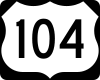
New York State Route 104
Encyclopedia
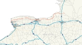
New York State Route 104 (NY 104) is a 182.41 miles (293.56 km) long east–west state highway
in Upstate New York
, United States
. It spans six counties and enters the vicinity of four cities—Niagara Falls
, Lockport
, Rochester
, and Oswego
—as it follows a routing largely parallel to that of the southern shoreline of Lake Ontario
, along a
ridge of the old shoreline of Glacial Lake Iroquois
. The western terminus of NY 104 is at an intersection with NY 384
in Niagara Falls, Niagara County
, while its eastern terminus is at a junction with NY 13
in the town of Williamstown
, Oswego County
. The portion of NY 104 between Rochester and the village of Webster
east of the city is a limited-access highway known as the Keeler Street Expressway west of NY 590
and the Irondequoit – Wayne County Expressway east of NY 590; from Williamson to Oswego, NY 104 is a super two
highway.
The majority of Ridge Road
and modern NY 104 from the village of Red Creek
to the town of Mexico
were originally designated as part of Route 30, an unsigned legislative route, early in the 20th century. All of Ridge Road and its continuation through Oswego to the hamlet of Maple View gained a signed designation by 1926 and became part of U.S. Route 104 (US 104), a United States Numbered Highway extending from Niagara Falls to Maple View, ca. 1935. US 104, which never connected to US 4
, its implied parent route, was redesignated as NY 104 ca. 1972. As part of the redesignation, NY 104 was extended east to NY 13
in Williamstown
over what had been New York State Route 126.
Over time, the 104 designation, whether it be US 104 or NY 104, has been shifted from surface streets to expressways and super two
s, particularly from Rochester east to Oswego. The first such realignment occurred in the 1940s in Wayne County
and was completed by the realignment of NY 104 onto the Irondequoit – Wayne County Expressway near Webster
in the 1980s.
 NY 104 begins near the Rainbow Bridge
at the intersection of First Street and Niagara Street (NY 384
) in downtown Niagara Falls
. The Seaway Trail
crosses over NY 384 and follows NY 104 north on First Street for one block to the Robert Moses State Parkway
, where the byway and NY 104 veer onto Main Street. NY 104 follows Main Street through the largely commercial west side of the city and intersects the northern terminus for both US 62
(Ferry Avenue and Walnut Avenue) and US 62 Business (Pine Avenue). North of US 62 Business, the area becomes more residential as NY 104 meets NY 182
southeast of the Whirlpool Rapids Bridge
. To the north, the name of NY 104 changes to Lewiston Road as it passes by the south campus of Niagara University
. Near the northern extent of the campus, NY 104 intersects the western terminus of NY 31
, here named College Avenue. At the city limits, NY 104 meets the northbound Robert Moses State Parkway by way of a half-interchange. The portion of NY 104 between Third Street and the Lewiston
town line is maintained by the city of Niagara Falls, and is the only part of NY 104 that is not maintained by the New York State Department of Transportation
.
Now in the town of Lewiston, NY 104 comes within view of the Niagara River
gorge and begins to run along its eastern rim. NY 104 meets the northern-most point of NY 61
at the northern campus of Niagara University. Past NY 61, the route passes by the Niagara Power Visitors Center and over the Robert Moses Niagara Power Plant. On the opposite side of the plant, NY 104 connects with Interstate 190
(I-190) at exit 25 via Upper Mountain Road and passes under the eastern approach to the Lewiston–Queenston Bridge, which links I-190 with Ontario
's Highway 405.
 Past I-190, NY 104 begins to deviate from the Niagara River. It heads through a small neighborhood situated between the Moses Parkway and NY 104 and intersects the northern end of NY 265
. North of this junction, NY 104 curves northeast to descend the Niagara Escarpment
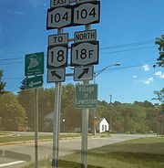
. As it heads downward in elevation, it intersects the western terminus of NY 18
by way of an interchange. As part of the same exit, NY 104 meets the parkway one more time as well as the southern terminus of NY 18F
near the village of Lewiston. Here, the Seaway Trail leaves NY 104 to follow NY 18F. East of the exit, NY 104 intersects NY 18 again by way of another interchange.
East of Lewiston village, NY 104 follows Ridge Road
through a sparsely populated area of Niagara County
. Much of this portion of NY 104 is bordered on its southern end by the Tuscarora Indian Reservation. At the Lewiston hamlet of Dickersonville, the extents of the reservation head south, and development along NY 104 increases slightly. NY 104 meets the northern terminus of NY 429
at the Lewiston–Cambria
town line and crosses over NY 425
at Streeters Corners. Just east of this location is an intersection with NY 93
in the community of Molyneaux Corners. The two routes form a concurrency east to Warrens Corners, a hamlet situated on the Cambria–Lockport
town line, where NY 93 turns south to serve the city of Lockport
.
NY 104 heads northeast through the extreme northwest corner of the town of Lockport to the town line, where it turns eastward to straddle the boundary between the towns of Lockport and Newfane
. As it approaches the hamlet of Wrights Corners, the amount of development along NY 104 increases substantially with the level of development peaking at the junction of NY 104 and NY 78
. The two routes join for roughly 0.35 mile (0.563269 km) into the town of Newfane before splitting north of the hamlet. Ridge Road continues northeast through a residential district, which gives way to open fields once more at Ridgewood. NY 104 turns east here, passing through the town of Hartland
and intersecting the southern terminus of NY 148
and the northern terminus of NY 271
. The route crosses into Orleans County
at a junction with the southern terminus of NY 269
, which straddles the county line.
 The route heads northeast through the town of Ridgeway
to the hamlet of the same name, where NY 104 meets NY 63
. NY 63 joins NY 104 east along Ridge Road for about 300 yards (274.3 m) before continuing north toward Lake Ontario
. NY 104, meanwhile, continues through the rural towns of Ridgeway and Gaines
to a junction with NY 279
north of Albion
. Not far to the east, NY 104 intersects NY 98
, the primary north–south highway through Albion, in the hamlet of Childs
. Just past the intersection on the north side of the road are two of the three cobblestone
buildings of the Cobblestone Historic District
, a National Historic Landmark
.
Farther east, Ridge Road enters the town of Murray
, where it meets the northern terminus of NY 387
and intersects NY 237
in the hamlet of Murray. The two routes join for just under a mile (1.6 km) before NY 237 breaks away to the south toward Holley
. NY 104 exits Orleans County 2 miles (3.2 km) later in the same fashion as it entered: by intersecting a state highway. After meeting the southern terminus of NY 272
, NY 104 crosses into Monroe County
and becomes West Ridge Road as it heads through the town of Clarkson
. In the densely-populated hamlet of the same name, NY 104 intersects NY 19
. The open fields return east of the hamlet, and largely surround Ridge Road as NY 104 intersects NY 260
. NY 104 heads onward into Parma
, where it widens to four lanes and has a junction with NY 259
in Parma Corners.
East of Parma Corners, development on NY 104 steadily increases as it heads toward the town of Greece
. By the Parma–Greece town line, where NY 104 intersects the southern terminus of NY 261
, Ridge Road is lined with commercial properties of varying size. Continuing east, NY 104 meets the northern terminus of NY 386
. Between NY 386 and NY 390
exit 24, NY 104 passes by several large shopping malls, the largest of which is The Mall at Greece Ridge
at the intersection of NY 104 and Long Pond Road. At NY 390, NY 104 widens to six lanes as it heads toward Rochester
. It enters the city limits upon meeting Mount Read Boulevard at an interchange.
In Rochester, NY 104 passes through an area known as Kodak Park
, the large industrial complex owned by Eastman Kodak
that occupies an entire neighborhood. In the middle of the complex, NY 104 crosses the Rochester and Southern Railroad
and the CSX Transportation
-owned Charlotte Running Track
and intersects the eastern terminus of NY 18. Continuing east, NY 104 crosses the Genesee River
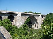
gorge on the Veterans Memorial Bridge
. On the opposite bank, it loses the name West Ridge Road and becomes a limited-access highway known as the Keeler Street Expressway.
 North of the first exit with St. Paul Street, Ridge Road resurfaces as East Ridge Road, which parallels the expressway to the north. NY 104 continues through Rochester and Irondequoit
, connecting to North Clinton Avenue, Seneca Avenue, Hudson Avenue, Carter Street, Portland Avenue, North Goodman Street and Culver Road by way of interchanges. Between the Goodman Street and Culver Road exits, NY 104 passes the Medley Centre
. East of Culver, NY 104 encounters NY 590
and connects to NY 590 southbound by way of an interchange. East Ridge Road runs through the middle of this interchange, although there are no connections between Ridge and NY 104. There is also no access from NY 104 eastbound to NY 590 northbound; eastbound traffic must take Culver Road in order to go north toward Sea Breeze. Just east of the NY 590 interchange, NY 104 becomes the Irondequoit – Wayne County Expressway and crosses the Irondequoit Bay
by way of the Irondequoit Bay Bridge
.
On the other side of the bridge in the town of Webster
, NY 104 has exits leading to Bay Road, Five Mile Line Road, Hard Road, and Holt Road prior to entering the village of Webster
. Within the village, NY 104 meets NY 250
(North Avenue) and Phillips Road by way of interchanges before reentering the surrounding town. The expressway loosely parallels the southern edge of the primary Xerox
campus to an exit with Salt Road, where it downgrades to a divided highway
as it continues east to Basket Road and the Monroe–Wayne
county line, partially delimited by NY 404
.
, where it meets the northern terminus of NY 350
in Ontario Center. The four-lane divided highway continues east to Williamson
, where the median separating the two directions of NY 104 comes to an end west of the hamlet of Williamson. In the center of the hamlet, NY 104 intersects the northern terminus of NY 21
. NY 104 narrows to two lanes east of Williamson as development along the route declines once more, giving way to open fields and thick forests.
 Near the center of the county in the town of Sodus
, NY 104 serves as the northern terminus of NY 88
northwest of the village of Sodus
. While NY 88 heads east into the village, NY 104 bypasses Sodus to the north. East of the village, Ridge Road and NY 104 intersect as Ridge Road flips to the north side of Route 104. The two highways follow parallel routings southeast toward Alton, where NY 104 intersects NY 14
. East of Alton, the gap between the two widens as Ridge Road veers north to access Sodus Bay
. NY 104, meanwhile, follows a nearly linear routing into the town of Huron
, the location of a junction with NY 414
.
NY 104 continues on the eastward routing to the vicinity of the village of Wolcott
, where it connects to the northern terminus of NY 89
via a half-diamond interchange south of the village. Northeast of this location in the town of Wolcott
, Ridge Road intersects NY 104 once again, returning to the south side of the route. The two roads follow parallel routings once more to a junction south of Red Creek
. At this rural intersection, NY 104 acts as the western terminus of both NY 104A
and NY 370
, both occupying an extension of Ridge Road. Just east of the intersection is the Wayne–Cayuga
county line. Only 7 miles (11 km) of the route are situated in Cayuga County, and the only junction of note within the county is with NY 38
, which it meets in the Sterling
hamlet of Martville. East of the junction, NY 104 turns sharply to the northeast and enters Oswego County
.
to the village of the same name
. Instead of entering the community, NY 104 bypasses it to the east. It intersects NY 3
east of Hannibal and heads north toward Lake Ontario. In the town of Oswego
, NY 104 meets the eastern terminus of NY 104A and assumes its northeasterly routing. It is here that the Seaway Trail rejoins NY 104. NY 104 heads along the Lake Ontario shoreline to the lakeside city of Oswego
, the first location with significant development along the route since Williamson. The route intersects Sweet Road, a connector leading to the campus of SUNY Oswego
, just west of the city limits.
 NY 104 enters the city as the two-laned West Seneca Street. At Baylis Street, the road widens to four lanes separated by a median. After seven blocks, NY 104 veers onto West Bridge Street, a four-lane street with no median. NY 104 continues along Bridge Street into downtown, where it intersects the northern terminus of NY 48
on the west bank of the Oswego River
and the northern terminus of NY 481
on the east bank. As NY 104 heads through eastern Oswego, it separates from East Bridge Street and curves east to follow a more inland routing. The route reverts back to two lanes as it exits the city limits.
The high level of development along NY 104 continues to the Scriba
hamlet of the same name, where it begins to become more sporadic and give way to fields and dense forests. NY 104 heads northeast to New Haven
and a junction with NY 104B
. While NY 104B heads northeast toward the lakeshore as part of the Seaway Trail, NY 104 cuts southeast to serve the village of Mexico
. In the village center, NY 104 briefly overlaps NY 3 and intersects the northern terminus of NY 69
. The route continues due east through the rural town of Mexico
to the small hamlet of Maple View, centered around the junction between NY 104 and US 11
. Just outside the hamlet, NY 104 meets I-81
at exit 34. Past I-81, NY 104 heads east and southeast for nine miles (14 km) through the predominantly rural towns of Albion
and Williamstown
to its eastern terminus at a junction with NY 13
.
 In 1908, the New York State Legislature established Route 30, an unsigned legislative route
extending from Niagara Falls
, Niagara County
in the southwest to Rouses Point
, Clinton County
, in the northeast. From Rochester
to Red Creek
, Route 30 was assigned to Ridge Road
. Between Red Creek and the hamlet of Union Square (now Maple View) in the town of Mexico
, it included most of modern NY 104. At the same time, the roadway alongside the Niagara River
between Ridge Road in Lewiston and Pine Avenue in downtown Niagara Falls
was designated, but not signed, as part of Route 18. By 1914, Route 30 was amended to also include the section of Ridge Road from Porter
(modern NY 429
) to Ridgeway
(NY 63
). In 1914, another section—from Ridgeway to the Orleans
–Monroe
county line—was also included in Route 30's definition as a spur route. The spur route became part of Route 30 on March 1, 1921, when the mainline route was realigned to follow Ridge Road between Ridgeway and Rochester.
When the first set of posted routes in New York
were assigned in 1924, the segments of Route 30 from Rochester to Red Creek and from Oswego to Maple View became part of NY 3
. Between Red Creek and Oswego, NY 3 was routed on what is now NY 104A
. Farther west, the portion of Route 18 from Niagara Falls to Lewiston was included as part of NY 34. By 1926, all of legislative Route 30 west of Rochester was designated as part of NY 31
. In the late 1920s, however, NY 31 was realigned to follow Ridge Road west from Porter to Lewiston. In the 1930 renumbering of state highways in New York, NY 34 became part of an extended NY 18
while NY 3E was assigned to the portion of former legislative Route 30 between Red Creek and Oswego. NY 3E was renumbered to NY 3F ca. 1932.
 US 104 was assigned across Upstate New York
ca. 1935, extending from Niagara Falls to Maple View via Lewiston, Rochester, and Oswego. It overlapped NY 18 from Niagara Falls to Lewiston and replaced NY 3 and NY 31 from Lewiston to Maple View (except from Red Creek to Oswego, where US 104 followed NY 3F instead). As a result, NY 31 was shifted south onto most of its modern alignment while NY 3 was rerouted south of Watertown
to follow what had been NY 3D. Although US 104 was technically a child route of US 4
, it did not connect to US 4. A highway extending eastward from US 11 and US 104 at Maple View to NY 13
in Williamstown
was designated as NY 126 ca. 1940.
When it was first assigned, US 104 dipped south to serve downtown Rochester instead of bypassing it to the north. US 104 left Ridge Road at Lake Avenue and followed Lake Avenue south to Main Street in downtown. It followed Main Street and Winton Road to Empire Boulevard, where it turned east to rejoin Ridge Road in Webster
. Ca. 1937, it was rerouted to continue east on Ridge Road over the Veterans Memorial Bridge
and through Irondequoit
to Culver Road. US 104 turned here, following Culver Road south to Empire Boulevard and the latter east to Winton Road, where it reconnected to its original routing through the city. The realignment created a significant overlap with NY 18, which joined US 104 in the vicinity of Kodak Park
and separated at Culver Road, where it headed north instead.
alignments for US 104 in Wayne
, Cayuga
, and Oswego
Counties. The new highway was built on a routing parallel to that of Ridge Road and served as a bypass of the communities along Ridge Road. The first portion of the super two, extending from the Monroe
–Wayne county line at Union Hill to west of Sodus
, was built in the mid-1940s and completed by 1947. An extension of the highway around Sodus to NY 414
in Huron
was constructed in the mid-1960s and opened by 1968. In between the end of the super two and Ridge Road, US 104 was routed on Lake Bluff Road. The remainder of the super two between Huron and Red Creek
was finished by 1974. East of the super two, a bypass was constructed around the village of Hannibal
during the early 1960s and opened to traffic by 1964.
 Similar conversion projects were also conducted elsewhere. In Irondequoit, the portion of the Sea Breeze Expressway (now NY 590
) from Empire Boulevard to Culver Road opened in the late 1950s. US 104 and NY 18 were extended eastward along East Ridge Road to meet the expressway at what is now exit 11. Both designations entered the freeway; however, NY 18 followed the roadway north to Culver Road while US 104 progressed south to Empire Boulevard, where it rejoined its former surface alignment towards Webster. The 0.71 miles (1.14 km) of Empire Boulevard between the Rochester city line and the Sea Breeze Expressway remains state-maintained to this day as NY 941B, an unsigned reference route.
In the mid-1960s, construction began on the Keeler Street Expressway, a limited-access highway extending across Irondequoit from the Genesee River
(at the Veterans Memorial Bridge) to the Sea Breeze Expressway. The first section from North Goodman Street to the Sea Breeze Expressway was completed by 1968 while the remainder opened in late 1969. The name of the expressway was derived from Keeler Street, a small residential street that originally connected to East Ridge Road and St. Paul Street by way of a traffic circle on the east bank of the Genesee River. The street was turned into a dead-end street as a result of the expressway's construction. US 104 was moved from East Ridge Road to the expressway, which remains known, albeit infrequently, as the Keeler Street Expressway to this day. NY 18 remained on East Ridge Road, however, reducing the overlap between US 104 and NY 18 to just the portion on the Veterans Bridge. NY 18 was truncated to its current eastern terminus ca. 1973, eliminating the overlap entirely.
The first segment of an eastward extension of the Keeler Street Expressway, named the Irondequoit – Wayne County Expressway, opened ca. 1971 between the Sea Breeze Expressway (at this point designated as part of NY 47
) and Five Mile Line Road. In between, US 104 crossed Irondequoit Bay
by way of the Irondequoit Bay Bridge
. US 104's former surface alignment between NY 47 and Five Mile Line Road was redesignated NY 404
while US 104 was temporarily realigned onto Five Mile Line Road between the expressway and Ridge Road to connect to its former alignment.
through central New York
was built on an alignment that closely paralleled US 11 from the Pennsylvania state line northward to the city of Watertown
. The portion of I-81 near Maple View was completed in late 1961, at which time US 104 was extended 1 miles (1.6 km) eastward over NY 126 to meet the new highway. NY 126 was truncated on its west end to the I-81 interchange as a result. US 104 was redesignated as NY 104 ca. 1972, making the route the third to bear the NY 104 designation. As part of the change, NY 104 was extended east to NY 13, completely supplanting NY 126.
By 1978, the frontage roads between Five Mile Line Road and NY 250 in Webster were completed. NY 104 was rerouted eastward along the roadways while NY 404 was extended over NY 104's old alignment to NY 250 in Webster. The section from NY 250 to the existing expressway at the Wayne County line was built in the late 1970s while the main carriageway of NY 104 between Five Mile Line Road and NY 250 was completed in the early 1980s. NY 404 was extended east along the former alignment of NY 104 to the county line upon the total completion of the Five Mile Line Road – NY 250 segment.
and town of Irondequoit
in Monroe County
. The route, which exists in the eastbound direction only, extends from the ramps connecting NY 104 to St. Paul Street east along East Ridge Road to Hudson Avenue, where it turns south to access NY 104. A 0.9 miles (1.4 km) long segment of NY 104 Truck follows the former alignment of US 104 east along East Ridge Road from St. Paul Street to Hudson Avenue.
|rowspan=2|37.60
|rowspan=2|
|rowspan=2|Southern terminus of NY 269
|-
|rowspan=9|Orleans
|rowspan=3|Ridgeway
|-
|-
|rowspan=2|62.30
|rowspan=2|
|rowspan=2|Southern terminus of NY 272
|-
|rowspan=28|Monroe
|rowspan=3|Clarkson
|-
|-
|colspan=3 align="center"|West end of freeway section
|-
|81.91
|Maplewood Drive
|
|-
|82.27
|St. Paul Street
|To Seneca Park Zoo
; eastbound exit and westbound entrance
|-
|82.69
|North Clinton Avenue / Seneca Avenue
|To Seneca Park Zoo; western terminus of frontage road
s
|-
|83.35
|Hudson Avenue
|Eastbound exit only
|-
|83.74
|Carter Street / Portland Avenue (east) / Hudson Avenue (west)
|
|-
|rowspan=4|Irondequoit
|84.40
|Goodman Street / Portland Avenue (west)
|To Rochester General Hospital; eastern terminus of frontage roads
|-
|85.33
|Culver Road (Seaway Trail
)
|
|-
|85.91
|
|
|-
|rowspan=2 colspan=3 align="center"|Irondequoit Bay Bridge
|-
|rowspan=5|Town of Webster
|-
|88.24
|Bay Road
|
|-
|90.28
|Five Mile Line Road
|Western terminus of frontage roads
|-
|90.98
|Hard Road / Holt Road
|Eastbound exit and entrance
|-
|91.87
|Hard Road / Holt Road
|Westbound exit and entrance
|-
|rowspan=2|Village of Webster
|92.57
|
|Eastern terminus of frontage roads
|-
|93.15
|Phillips Road
|To Xerox
Wilson Center; eastbound exit and westbound entrance
|-
|rowspan=3|Town of Webster
|94.12
|Salt Road
|
|-
|colspan=3 align="center"|East end of freeway section
|-
|rowspan=2|95.43
|rowspan=2|
|rowspan=2|Eastern terminus of NY 404
|-
|rowspan=8|Wayne
|rowspan=2|Ontario
|-
State highway
State highway, state road or state route can refer to one of three related concepts, two of them related to a state or provincial government in a country that is divided into states or provinces :#A...
in Upstate New York
Upstate New York
Upstate New York is the region of the U.S. state of New York that is located north of the core of the New York metropolitan area.-Definition:There is no clear or official boundary between Upstate New York and Downstate New York...
, United States
United States
The United States of America is a federal constitutional republic comprising fifty states and a federal district...
. It spans six counties and enters the vicinity of four cities—Niagara Falls
Niagara Falls, New York
Niagara Falls is a city in Niagara County, New York, United States. As of the 2010 census, the city had a total population of 50,193, down from the 55,593 recorded in the 2000 census. It is across the Niagara River from Niagara Falls, Ontario , both named after the famed Niagara Falls which they...
, Lockport
Lockport (city), New York
Lockport is a city in Niagara County, New York, United States. The population was 21,165 at the 2010 census. The name is derived from a set of Erie canal locks within the city. Lockport is the county seat of Niagara County and is surrounded by the town of Lockport...
, Rochester
Rochester, New York
Rochester is a city in Monroe County, New York, south of Lake Ontario in the United States. Known as The World's Image Centre, it was also once known as The Flour City, and more recently as The Flower City...
, and Oswego
Oswego, New York
Oswego is a city in Oswego County, New York, United States. The population was 18,142 at the 2010 census. Oswego is located on Lake Ontario in north-central New York and promotes itself as "The Port City of Central New York"...
—as it follows a routing largely parallel to that of the southern shoreline of Lake Ontario
Lake Ontario
Lake Ontario is one of the five Great Lakes of North America. It is bounded on the north and southwest by the Canadian province of Ontario, and on the south by the American state of New York. Ontario, Canada's most populous province, was named for the lake. In the Wyandot language, ontarío means...
, along a
ridge of the old shoreline of Glacial Lake Iroquois
Glacial Lake Iroquois
Glacial Lake Iroquois was a prehistoric proglacial lake that existed at the end of the last ice age approximately 13,000 years ago.The lake was essentially an enlargement of the present Lake Ontario that formed because the St. Lawrence River downstream from the lake was blocked by the ice sheet...
. The western terminus of NY 104 is at an intersection with NY 384
New York State Route 384
New York State Route 384 is a state highway in Western New York in the United States. It is a north–south route extending from the city of Buffalo, Erie County to the city of Niagara Falls, Niagara County, and is one of several routes directly connecting the two cities. The southern terminus...
in Niagara Falls, Niagara County
Niagara County, New York
Niagara County is a county located in the U.S. state of New York. As of the 2010 census, the population was 216,469. The county seat is Lockport. The county name is from the Iroquois word Onguiaahra; meaning the strait or thunder of waters. It is the location of Niagara Falls and Fort Niagara, and...
, while its eastern terminus is at a junction with NY 13
New York State Route 13
New York State Route 13 is a state highway that runs mainly north–south for between NY 14 in Horseheads and NY 3 west of Pulaski in Central New York in the United States. In between, NY 13 intersects with Interstate 81 in Cortland and Pulaski and meets the New York...
in the town of Williamstown
Williamstown, New York
Williamstown is a town in Oswego County, New York, United States. The population was 1,350 at the 2000 census.The Town of Williamstown is on the county's east border.- History :The Town of Williamstown was created in 1804 from the Town of Mexico....
, Oswego County
Oswego County, New York
Oswego County is a county located in the U.S. state of New York. As of the 2010 Census, the estimated population was 122,109. The City of Oswego and the Village of Pulaski serve as the dual county seats in a two shire system of government...
. The portion of NY 104 between Rochester and the village of Webster
Webster (village), New York
Webster is a village in Monroe County, New York, United States. The population was 5,216 at the 2000 census. The village and town are named after orator and statesman Daniel Webster....
east of the city is a limited-access highway known as the Keeler Street Expressway west of NY 590
New York State Route 590
New York State Route 590 is a north–south state highway located in the eastern suburbs of Rochester, New York, in the United States...
and the Irondequoit – Wayne County Expressway east of NY 590; from Williamson to Oswego, NY 104 is a super two
Super two
A super two, super two-lane highway or wide two lane is a two-lane surface road built to high standards, typically including partial control of access, occasional passing lanes and hard shoulders...
highway.
The majority of Ridge Road
Ridge Road (Western New York)
Ridge Road is a east–west road that traverses four counties in Upstate New York in the United States. It is named for the rise atop which the road was built, a mound of sand and gravel that was formed when it was the shoreline of ancient Glacial Lake Iroquois...
and modern NY 104 from the village of Red Creek
Red Creek, New York
Red Creek is a village in Wayne County, New York, United States. The population was 521 at the 2000 census.The Village of Red Creek is in the eastern part of the Town of Wolcott. The village is west of Syracuse, New York.- History :...
to the town of Mexico
Mexico (town), New York
Mexico is a town in the northeast part of Oswego County, New York, United States. The population was 5,181 at the 2000 census. The town contains a village, also called Mexico. NY 104/Main Street passes through the village. NY 69 passes through the town of Mexico and comes to an end in the village,...
were originally designated as part of Route 30, an unsigned legislative route, early in the 20th century. All of Ridge Road and its continuation through Oswego to the hamlet of Maple View gained a signed designation by 1926 and became part of U.S. Route 104 (US 104), a United States Numbered Highway extending from Niagara Falls to Maple View, ca. 1935. US 104, which never connected to US 4
U.S. Route 4 in New York
U.S. Route 4 is a part of the U.S. Highway System that runs from East Greenbush, New York, to Portsmouth, New Hampshire. In the U.S. state of New York, US 4 extends from an intersection with US 9 and US 20 in East Greenbush to the Vermont state line northeast of Whitehall...
, its implied parent route, was redesignated as NY 104 ca. 1972. As part of the redesignation, NY 104 was extended east to NY 13
New York State Route 13
New York State Route 13 is a state highway that runs mainly north–south for between NY 14 in Horseheads and NY 3 west of Pulaski in Central New York in the United States. In between, NY 13 intersects with Interstate 81 in Cortland and Pulaski and meets the New York...
in Williamstown
Williamstown, New York
Williamstown is a town in Oswego County, New York, United States. The population was 1,350 at the 2000 census.The Town of Williamstown is on the county's east border.- History :The Town of Williamstown was created in 1804 from the Town of Mexico....
over what had been New York State Route 126.
Over time, the 104 designation, whether it be US 104 or NY 104, has been shifted from surface streets to expressways and super two
Super two
A super two, super two-lane highway or wide two lane is a two-lane surface road built to high standards, typically including partial control of access, occasional passing lanes and hard shoulders...
s, particularly from Rochester east to Oswego. The first such realignment occurred in the 1940s in Wayne County
Wayne County, New York
Wayne County is a county located in the US state of New York. It is part of the Rochester, New York Metropolitan Statistical Area and lies on the south shore of Lake Ontario, forming part of the northern border of the United States with Canada. The name honors General Anthony Wayne, an American...
and was completed by the realignment of NY 104 onto the Irondequoit – Wayne County Expressway near Webster
Webster (village), New York
Webster is a village in Monroe County, New York, United States. The population was 5,216 at the 2000 census. The village and town are named after orator and statesman Daniel Webster....
in the 1980s.
Niagara County
Rainbow Bridge (Niagara Falls)
The Rainbow Bridge at Niagara Falls is an international steel arch bridge across the Niagara River gorge, and is a world-famous tourist site. It connects the cities of Niagara Falls, New York, United States , and Niagara Falls, Ontario, Canada .-Construction:The Rainbow Bridge was built near the...
at the intersection of First Street and Niagara Street (NY 384
New York State Route 384
New York State Route 384 is a state highway in Western New York in the United States. It is a north–south route extending from the city of Buffalo, Erie County to the city of Niagara Falls, Niagara County, and is one of several routes directly connecting the two cities. The southern terminus...
) in downtown Niagara Falls
Niagara Falls, New York
Niagara Falls is a city in Niagara County, New York, United States. As of the 2010 census, the city had a total population of 50,193, down from the 55,593 recorded in the 2000 census. It is across the Niagara River from Niagara Falls, Ontario , both named after the famed Niagara Falls which they...
. The Seaway Trail
Seaway Trail
The Great Lakes Seaway Trail, formerly named and commonly known as the Seaway Trail, is a National Scenic Byway in the northeastern United States, mostly contained in New York but with a small segment in Pennsylvania...
crosses over NY 384 and follows NY 104 north on First Street for one block to the Robert Moses State Parkway
Robert Moses State Parkway
The Robert Moses State Parkway is an long north–south highway in western Niagara County, New York, United States. Its southern terminus is at the LaSalle Expressway on the east bank of the Niagara River in Niagara Falls. The northern terminus is at NY 18 at Four Mile Creek State Park in...
, where the byway and NY 104 veer onto Main Street. NY 104 follows Main Street through the largely commercial west side of the city and intersects the northern terminus for both US 62
U.S. Route 62 in New York
U.S. Route 62 is a part of the U.S. Highway System that runs from the United States – Mexico border at El Paso, Texas, to Niagara Falls, New York. In the U.S. state of New York, US 62 extends from the New York – Pennsylvania border south of Jamestown to an intersection with...
(Ferry Avenue and Walnut Avenue) and US 62 Business (Pine Avenue). North of US 62 Business, the area becomes more residential as NY 104 meets NY 182
New York State Route 182
New York State Route 182 is a state highway in Niagara County, New York, United States. It serves as a signed connection between the Whirlpool Rapids Bridge over the Niagara River and the Niagara Falls International Airport east of the city of Niagara Falls...
southeast of the Whirlpool Rapids Bridge
Whirlpool Rapids Bridge
The Whirlpool Rapids Bridge, commonly called the Whirlpool Bridge, and until 1937, known as the Lower Steel Arch Bridge, is a spandrel braced, riveted, two-hinged arch bridge. It crosses the international border between Canada and the United States, connecting the commercial downtown districts of...
. To the north, the name of NY 104 changes to Lewiston Road as it passes by the south campus of Niagara University
Niagara University
Niagara University is a Catholic university in the Vincentian tradition, located in the Town of Lewiston in Niagara County, New York. Originally founded by the Congregation of the Mission in 1856 as Our Lady of Angels Seminary, it became Niagara University in 1883. The University is still run by...
. Near the northern extent of the campus, NY 104 intersects the western terminus of NY 31
New York State Route 31
New York State Route 31 is a state highway that extends for across western and central New York in the United States. The western terminus of the route is at an intersection with NY 104 in the city of Niagara Falls. Its eastern terminus is at a traffic circle with NY 26 in Vernon...
, here named College Avenue. At the city limits, NY 104 meets the northbound Robert Moses State Parkway by way of a half-interchange. The portion of NY 104 between Third Street and the Lewiston
Lewiston, New York
Lewiston is a village in Niagara County, New York, United States. The population was 2,781 at the 2000 census. The village is named after Morgan Lewis, an early 19th-century governor of New York. It is part of the Buffalo–Niagara Falls Metropolitan Statistical Area.The Village of Lewiston,...
town line is maintained by the city of Niagara Falls, and is the only part of NY 104 that is not maintained by the New York State Department of Transportation
New York State Department of Transportation
The New York State Department of Transportation is responsible for the development and operation of highways, railroads, mass transit systems, ports, waterways and aviation facilities in the U.S...
.
Now in the town of Lewiston, NY 104 comes within view of the Niagara River
Niagara River
The Niagara River flows north from Lake Erie to Lake Ontario. It forms part of the border between the Province of Ontario in Canada and New York State in the United States. There are differing theories as to the origin of the name of the river...
gorge and begins to run along its eastern rim. NY 104 meets the northern-most point of NY 61
New York State Route 61
New York State Route 61 is a state highway located almost entirely in the city of Niagara Falls in Niagara County, New York in the United States. The road runs across the city in a northwest–southeast direction, terminating at NY 384 at its southern extent and NY 104 at its northern...
at the northern campus of Niagara University. Past NY 61, the route passes by the Niagara Power Visitors Center and over the Robert Moses Niagara Power Plant. On the opposite side of the plant, NY 104 connects with Interstate 190
Interstate 190 (New York)
Interstate 190 runs 28.34 miles from Interstate 90 near Buffalo, New York to Lewiston, New York via Niagara Falls. Parts of this highway were built on the former rights-of-way of the Lehigh Valley Railroad and the Erie Canal. It is referred to by locals as The One-Ninety...
(I-190) at exit 25 via Upper Mountain Road and passes under the eastern approach to the Lewiston–Queenston Bridge, which links I-190 with Ontario
Ontario
Ontario is a province of Canada, located in east-central Canada. It is Canada's most populous province and second largest in total area. It is home to the nation's most populous city, Toronto, and the nation's capital, Ottawa....
's Highway 405.
New York State Route 265
New York State Route 265 is a state highway located in the western part of New York in the United States. NY 265 is a north–south route that roughly parallels the western parts of the Niagara River in Erie County and Niagara County...
. North of this junction, NY 104 curves northeast to descend the Niagara Escarpment
Niagara Escarpment
The Niagara Escarpment is a long escarpment, or cuesta, in the United States and Canada that runs westward from New York State, through Ontario, Michigan, Wisconsin and Illinois...
. As it heads downward in elevation, it intersects the western terminus of NY 18
New York State Route 18
New York State Route 18 is an east–west state highway in western New York in the United States. It runs parallel to the south shore of Lake Ontario for most of its length between Niagara County and Monroe County...
by way of an interchange. As part of the same exit, NY 104 meets the parkway one more time as well as the southern terminus of NY 18F
New York State Route 18F
New York State Route 18F is a long state highway in northwestern Niagara County, New York, United States. The southern terminus of the route is at an interchange with NY 104 and the Robert Moses State Parkway just east of the village of Lewiston. The northern terminus is at an...
near the village of Lewiston. Here, the Seaway Trail leaves NY 104 to follow NY 18F. East of the exit, NY 104 intersects NY 18 again by way of another interchange.
East of Lewiston village, NY 104 follows Ridge Road
Ridge Road (Western New York)
Ridge Road is a east–west road that traverses four counties in Upstate New York in the United States. It is named for the rise atop which the road was built, a mound of sand and gravel that was formed when it was the shoreline of ancient Glacial Lake Iroquois...
through a sparsely populated area of Niagara County
Niagara County, New York
Niagara County is a county located in the U.S. state of New York. As of the 2010 census, the population was 216,469. The county seat is Lockport. The county name is from the Iroquois word Onguiaahra; meaning the strait or thunder of waters. It is the location of Niagara Falls and Fort Niagara, and...
. Much of this portion of NY 104 is bordered on its southern end by the Tuscarora Indian Reservation. At the Lewiston hamlet of Dickersonville, the extents of the reservation head south, and development along NY 104 increases slightly. NY 104 meets the northern terminus of NY 429
New York State Route 429
New York State Route 429 is a north–south state highway located entirely within Niagara County, New York, in the United States. It extends for from an intersection with NY 265 and NY 384 in North Tonawanda to a junction with NY 104 on the border between the towns of Cambria...
at the Lewiston–Cambria
Cambria, New York
Cambria is a town in Niagara County, New York, USA. The population was 5,839 at the 2010 census. Cambria is an early name for Wales.The Town of Cambria is in the center of Niagara County.New York State Route 93 passes through the town.- History :...
town line and crosses over NY 425
New York State Route 425
New York State Route 425 is a New York state highway that runs from NY 18 in Wilson, New York on the shore of Lake Ontario to a connection with Interstate 290 in the Town of Tonawanda...
at Streeters Corners. Just east of this location is an intersection with NY 93
New York State Route 93
New York State Route 93 is a state highway in western New York in the United States. It runs in a northwest–southeast direction between NY 18F near the Niagara River in the village of Youngstown and NY 5 just south of the village of Akron...
in the community of Molyneaux Corners. The two routes form a concurrency east to Warrens Corners, a hamlet situated on the Cambria–Lockport
Lockport (town), New York
Lockport is a town in Niagara County, New York, United States. The population was 20,529 at the 2010 census. The name is derived from the series of canal locks on the Erie Canal...
town line, where NY 93 turns south to serve the city of Lockport
Lockport (city), New York
Lockport is a city in Niagara County, New York, United States. The population was 21,165 at the 2010 census. The name is derived from a set of Erie canal locks within the city. Lockport is the county seat of Niagara County and is surrounded by the town of Lockport...
.
NY 104 heads northeast through the extreme northwest corner of the town of Lockport to the town line, where it turns eastward to straddle the boundary between the towns of Lockport and Newfane
Newfane, New York
Newfane is a town in Niagara County, New York, USA. The population was 9,666 at the 2010 census. The name was suggested by an early settler.The Town of Newfane is in the north-central part of the county, north of the City of Lockport.- History :...
. As it approaches the hamlet of Wrights Corners, the amount of development along NY 104 increases substantially with the level of development peaking at the junction of NY 104 and NY 78
New York State Route 78
New York State Route 78 , most commonly known as Transit Road, is a state highway in Western New York, USA. While it is signed north–south, the lower portion runs in an east–west direction across Wyoming County, from its beginning north of the Village of Gainesville.NY 78 is...
. The two routes join for roughly 0.35 mile (0.563269 km) into the town of Newfane before splitting north of the hamlet. Ridge Road continues northeast through a residential district, which gives way to open fields once more at Ridgewood. NY 104 turns east here, passing through the town of Hartland
Hartland, New York
Hartland is a town in Niagara County, New York, USA.The population was 4,117 at the 2010 census.The town is named after Hartland, Vermont, the homeplace of some early settlers.The Town of Hartland is on the eastern border of the county.- History :...
and intersecting the southern terminus of NY 148
New York State Route 148
New York State Route 148 is a state highway in Niagara County, New York, United States. It runs north–south between a junction with NY 104 in the town of Hartland and NY 18 north of the village of Barker. The entire length of NY 148 is maintained by Niagara County as County...
and the northern terminus of NY 271
New York State Route 271
New York State Route 271 is a north–south state highway in eastern Niagara County, New York, in the United States. It primarily serves as Middleport's Main Street, connecting NY 31 in the south to NY 104 in the north. The southernmost portion of NY 271 is concurrent with...
. The route crosses into Orleans County
Orleans County, New York
As of the census of 2000, there were 44,171 people, 15,363 households, and 10,846 families residing in the county. The population density was 113 people per square mile . There were 17,347 housing units at an average density of 44 per square mile...
at a junction with the southern terminus of NY 269
New York State Route 269
New York State Route 269 is a north–south state highway in located in western New York in the United States. The highway runs for along the Niagara–Orleans county line and is named County Line Road. The southern terminus of NY 269 is at an intersection with NY 104 in the hamlet of...
, which straddles the county line.
Orleans and Monroe Counties
Ridgeway, New York
Ridgeway, New York is a town in Orleans County, New York, United States. The population was 6,886 at the 2000 census. The name of the town is derived from "Ridge Road," an important highway in the 19th century....
to the hamlet of the same name, where NY 104 meets NY 63
New York State Route 63
New York State Route 63 is a state highway in the western part of New York in the United States. The southern terminus of the route is at an intersection with NY 15 and NY 21 in the village of Wayland in Steuben County. Its northern end is at a junction with NY 18 in the town...
. NY 63 joins NY 104 east along Ridge Road for about 300 yards (274.3 m) before continuing north toward Lake Ontario
Lake Ontario
Lake Ontario is one of the five Great Lakes of North America. It is bounded on the north and southwest by the Canadian province of Ontario, and on the south by the American state of New York. Ontario, Canada's most populous province, was named for the lake. In the Wyandot language, ontarío means...
. NY 104, meanwhile, continues through the rural towns of Ridgeway and Gaines
Gaines, New York
Gaines is a town in Orleans County, New York, United States. The population was 3,740 at the 2000 census. The town is named after General Edmund Pendleton Gaines, who defended the area during the War of 1812....
to a junction with NY 279
New York State Route 279
New York State Route 279 is a north–south state highway in Orleans County, New York, in the United States. The southern terminus of the route is at an intersection with NY 98 north of the village of Albion in the town of Gaines...
north of Albion
Albion (village), Orleans County, New York
Albion is a village in Orleans County, New York, United States. The population was 7,438 at the 2000 census. The village is centrally located in the county and is partly in both the towns of Albion and Gaines. It is the county seat of Orleans County and is about west north-west of the City of...
. Not far to the east, NY 104 intersects NY 98
New York State Route 98
New York State Route 98 is a state highway in the western part of New York in the United States. The southern terminus of the route is at an intersection with U.S. Route 219 in the town of Great Valley in Cattaraugus County...
, the primary north–south highway through Albion, in the hamlet of Childs
Childs, New York
Childs, New York is an unincorporated hamlet in the town of Gaines in Orleans County, New York, USA. It is named after Judge Henry Childs and previously known as "Proctor's Corners" and "Fair Haven." It is the location of the Cobblestone Historic District that was listed on the National Register of...
. Just past the intersection on the north side of the road are two of the three cobblestone
Cobblestone architecture
Cobblestone architecture refers to the use of cobblestones embedded in mortar as method for erecting walls on houses and commercial buildings.-History:Evidence of the use of cobblestones in building has been found in the ruins of Hierakonpolis...
buildings of the Cobblestone Historic District
Cobblestone Historic District
The Cobblestone Historic District is located along state highway NY 104 in Childs, New York, United States. It comprises three buildings that exemplify the cobblestone architecture developed to a high degree in the regions of upstate New York near Lake Ontario and exported to other areas with...
, a National Historic Landmark
National Historic Landmark
A National Historic Landmark is a building, site, structure, object, or district, that is officially recognized by the United States government for its historical significance...
.
Farther east, Ridge Road enters the town of Murray
Murray, New York
Murray is a town in Orleans County, New York, United States. The population was 6,259 at the 2000 census.The Town of Murray is on the east border of the county, northwest of the City of Rochester.- History :Murray was first settled around 1809....
, where it meets the northern terminus of NY 387
New York State Route 387
New York State Route 387 is a state highway located within the town of Murray in Orleans County, New York, in the United States. It serves as a north–south connector between NY 31 in the hamlet of Fancher and NY 104 midway between the hamlets of East Gaines and Murray...
and intersects NY 237
New York State Route 237
New York State Route 237 is a north–south state highway located in the western part of New York in the United States. The southern terminus of the route is at an intersection with NY 5 in Stafford. Its northern terminus is at an interchange with the Lake Ontario State Parkway...
in the hamlet of Murray. The two routes join for just under a mile (1.6 km) before NY 237 breaks away to the south toward Holley
Holley, New York
Holley is a village in the town of Murray in Orleans County, New York, United States. The population was 1,802 at the 2000 census. It is part of the Rochester Metropolitan Statistical Area.- History :The village of Holley was incorporated in 1850...
. NY 104 exits Orleans County 2 miles (3.2 km) later in the same fashion as it entered: by intersecting a state highway. After meeting the southern terminus of NY 272
New York State Route 272
New York State Route 272 is a north–south state highway in the western portion of New York in the United States. It extends for just over along the Orleans–Monroe county line from an intersection with NY 104 in Clarkson to the Lake Ontario shoreline just north of an interchange with the...
, NY 104 crosses into Monroe County
Monroe County, New York
Monroe County is a county located in the U.S. state of New York. As of the 2010 census, the population was 744,344. It is named after James Monroe, fifth President of the United States of America. Its county seat is the city of Rochester....
and becomes West Ridge Road as it heads through the town of Clarkson
Clarkson, New York
Clarkson is a town in Monroe County, New York, USA. The population was 6,736 at the 2010 census. The town is named after General Matthew Clarkson.The Town of Clarkson is on the west border of the county and is west of the City of Rochester.-History:...
. In the densely-populated hamlet of the same name, NY 104 intersects NY 19
New York State Route 19
New York State Route 19 is a north–south state highway in Western New York in the United States. It is the longest state highway in that region, and the only other one besides NY 14 to completely transect the state from the Pennsylvania state line to the shore of Lake Ontario...
. The open fields return east of the hamlet, and largely surround Ridge Road as NY 104 intersects NY 260
New York State Route 260
New York State Route 260 is a north–south state highway in Monroe County, New York, in the United States. The southern terminus of the route is at an intersection with NY 31 in the town of Sweden. Its northern terminus is at a junction with the Lake Ontario State Parkway in the town of...
. NY 104 heads onward into Parma
Parma, New York
Parma is a town in Monroe County, New York, United States. The population was 15,633 at the 2010 census.The Town of Parma, then in Genesee County, was organized in 1808, named after Parma in Italy.-Geography:...
, where it widens to four lanes and has a junction with NY 259
New York State Route 259
New York State Route 259 is a north–south state highway located west of Rochester in Monroe County, New York, United States. The southern terminus of the route is at NY 33A in the hamlet of West Chili within the town of Chili. Its northern terminus is at the Lake Ontario State Parkway in...
in Parma Corners.
East of Parma Corners, development on NY 104 steadily increases as it heads toward the town of Greece
Greece (town), New York
Greece is a town in Monroe County, New York, United States. As of the 2010 United States census, the town had a total population of 96,095. The town motto is "Discover the Promise."...
. By the Parma–Greece town line, where NY 104 intersects the southern terminus of NY 261
New York State Route 261
New York State Route 261 is a north–south state highway located west of the city of Rochester in Monroe County, New York, in the United States. It extends for through mostly rural areas from an intersection with NY 104 on the Greece–Parma town line to a dead end at the Lake Ontario...
, Ridge Road is lined with commercial properties of varying size. Continuing east, NY 104 meets the northern terminus of NY 386
New York State Route 386
New York State Route 386 is a north–south state highway located in the western suburbs of the city of Rochester in Monroe County, New York, in the United States. Its southern terminus is at an intersection with NY 383 in the village of Scottsville. The northern end of the highway is...
. Between NY 386 and NY 390
New York State Route 390
New York State Route 390 is a north–south state highway located along the western edge of the city of Rochester, New York, in the United States. The route, a limited-access northward continuation of Interstate 390 , extends for from I-490 in Gates to the Lake Ontario State Parkway in...
exit 24, NY 104 passes by several large shopping malls, the largest of which is The Mall at Greece Ridge
The Mall at Greece Ridge
The Mall at Greece Ridge is located in Greece, a suburb of Rochester, New York, and managed by Wilmorite Management Group LLC. It contains 140 stores and restaurants in the main complex, with 10 big box retailers including Dick's Sporting Goods, Bed Bath & Beyond, Barnes & Noble, Michaels,...
at the intersection of NY 104 and Long Pond Road. At NY 390, NY 104 widens to six lanes as it heads toward Rochester
Rochester, New York
Rochester is a city in Monroe County, New York, south of Lake Ontario in the United States. Known as The World's Image Centre, it was also once known as The Flour City, and more recently as The Flower City...
. It enters the city limits upon meeting Mount Read Boulevard at an interchange.
In Rochester, NY 104 passes through an area known as Kodak Park
Kodak Park
Eastman Business Park, formerly Kodak Park, is a large manufacturing and industrial complex in the city of Rochester, New York, in the United States. The complex is run by Eastman Kodak and is located north of downtown Rochester and south of Lake Ontario...
, the large industrial complex owned by Eastman Kodak
Eastman Kodak
Eastman Kodak Company is a multinational imaging and photographic equipment, materials and services company headquarted in Rochester, New York, United States. It was founded by George Eastman in 1892....
that occupies an entire neighborhood. In the middle of the complex, NY 104 crosses the Rochester and Southern Railroad
Rochester and Southern Railroad
The Rochester and Southern Railroad , a subsidiary of Genesee & Wyoming Inc., is a class III shortline that runs from the city of Rochester in Monroe County to Silver Springs, NY. The RSR started in 1986, when the B&O sold off its Buffalo and Rochester branches...
and the CSX Transportation
CSX Transportation
CSX Transportation operates a Class I railroad in the United States known as the CSX Railroad. It is the main subsidiary of the CSX Corporation. The company is headquartered in Jacksonville, Florida, and owns approximately 21,000 route miles...
-owned Charlotte Running Track
Charlotte Running Track
The Charlotte Running Track, locally known as the Charlotte Runner or the Charlotte Branch, is a CSX Transportation-controlled branch line located in Rochester, New York...
and intersects the eastern terminus of NY 18. Continuing east, NY 104 crosses the Genesee River
Genesee River
The Genesee River is a North American river flowing northward through the Twin Tiers of Pennsylvania and New York. The river provided the original power for the Rochester area's 19th century mills and still provides hydroelectric power for downtown Rochester....
gorge on the Veterans Memorial Bridge
Veterans Memorial Bridge (Rochester, New York)
The Veterans Memorial Bridge in Rochester, New York, carries NY Route 104 across the Genesee River. The bridge is an architecturally significant concrete arch faced with white granite. Conceived in 1928 and finished in 1931, the span is the longest bridge in Rochester at 981 feet...
. On the opposite bank, it loses the name West Ridge Road and becomes a limited-access highway known as the Keeler Street Expressway.
Irondequoit, New York
Irondequoit is a town in Monroe County, New York, USA. As of the 2010 census, the coterminous town-CDP had a total population of 51,692...
, connecting to North Clinton Avenue, Seneca Avenue, Hudson Avenue, Carter Street, Portland Avenue, North Goodman Street and Culver Road by way of interchanges. Between the Goodman Street and Culver Road exits, NY 104 passes the Medley Centre
Medley Centre
Medley Centre is a mostly vacant shopping mall in Irondequoit, New York near Rochester. The mall opened in 1990 as Irondequoit Mall, but early success gave way to dwindling patronage in the face of competition and a perception that crime was common...
. East of Culver, NY 104 encounters NY 590
New York State Route 590
New York State Route 590 is a north–south state highway located in the eastern suburbs of Rochester, New York, in the United States...
and connects to NY 590 southbound by way of an interchange. East Ridge Road runs through the middle of this interchange, although there are no connections between Ridge and NY 104. There is also no access from NY 104 eastbound to NY 590 northbound; eastbound traffic must take Culver Road in order to go north toward Sea Breeze. Just east of the NY 590 interchange, NY 104 becomes the Irondequoit – Wayne County Expressway and crosses the Irondequoit Bay
Irondequoit Bay
Irondequoit Bay is a large body of water located in northeastern Monroe County, New York. The bay, roughly wide and in length, is fed by Irondequoit Creek to the south and flows into Lake Ontario at its northern end...
by way of the Irondequoit Bay Bridge
Irondequoit Bay Bridge
Irondequoit Bay Bridge is located near Rochester, New York and carries Route 104 across the Irondequoit Bay between Irondequoit and Webster near the intersection with Rt 590. According to the National Bridge Inventory the bridge was built in 1967. Its total span is with nine spans and an...
.
On the other side of the bridge in the town of Webster
Webster (town), New York
Webster is a town in the northeast corner of Monroe County, New York, United States. The town is named after orator and statesman Daniel Webster. The population was 42,641 at the 2010 census....
, NY 104 has exits leading to Bay Road, Five Mile Line Road, Hard Road, and Holt Road prior to entering the village of Webster
Webster (village), New York
Webster is a village in Monroe County, New York, United States. The population was 5,216 at the 2000 census. The village and town are named after orator and statesman Daniel Webster....
. Within the village, NY 104 meets NY 250
New York State Route 250
New York State Route 250 is a north–south state highway in the eastern portion of Monroe County, New York, in the United States. It extends for just over from an intersection with NY 96 in the town of Perinton to a junction with Lake Road near the Lake Ontario shoreline in the...
(North Avenue) and Phillips Road by way of interchanges before reentering the surrounding town. The expressway loosely parallels the southern edge of the primary Xerox
Xerox
Xerox Corporation is an American multinational document management corporation that produced and sells a range of color and black-and-white printers, multifunction systems, photo copiers, digital production printing presses, and related consulting services and supplies...
campus to an exit with Salt Road, where it downgrades to a divided highway
Divided Highway
Divided Highway is a compilation album by American rock band The Doobie Brothers, released in 2003. . All tracks are taken from the albums Cycles and Brotherhood .-Track listing:...
as it continues east to Basket Road and the Monroe–Wayne
Wayne County, New York
Wayne County is a county located in the US state of New York. It is part of the Rochester, New York Metropolitan Statistical Area and lies on the south shore of Lake Ontario, forming part of the northern border of the United States with Canada. The name honors General Anthony Wayne, an American...
county line, partially delimited by NY 404
New York State Route 404
New York State Route 404 is an east–west state highway located in eastern Monroe County, New York, in the United States. It extends for just over from an interchange with NY 590 in Irondequoit to an intersection with NY 104 on the Monroe–Wayne County line in the town of Webster...
.
Wayne and Cayuga Counties
As Ridge Road follows NY 104 to the south, Route 104 continues east through OntarioOntario, New York
Ontario is a town in the northwest corner of Wayne County, New York, United States. The population was 9,778 at the 2000 census, and 10,136 at the 2010 census. The town is named after the Great Lake on its northern border.- History :...
, where it meets the northern terminus of NY 350
New York State Route 350
New York State Route 350 is a north–south state highway in western Wayne County, New York, in the United States. It extends for from an intersection with NY 31 and NY 31F in the village of Macedon to a junction with NY 104 in the town of Ontario...
in Ontario Center. The four-lane divided highway continues east to Williamson
Williamson, New York
Williamson is an Upstate New York town in the northwest part of Wayne County, New York, U.S. on the south shore of Lake Ontario. The population was 6,777 at the time of the 2000 census. The town is named after Charles Williamson, a land agent of the Pultney Estate...
, where the median separating the two directions of NY 104 comes to an end west of the hamlet of Williamson. In the center of the hamlet, NY 104 intersects the northern terminus of NY 21
New York State Route 21
New York State Route 21 is a state highway extending for through the western part of New York in the United States. The southern terminus of the route is at NY 417 in Andover. The northern terminus is at NY 104 in Williamson...
. NY 104 narrows to two lanes east of Williamson as development along the route declines once more, giving way to open fields and thick forests.
Sodus (town), New York
Sodus is a town in Wayne County, New York, USA. The population was 8,949 at the 2000 census. The town takes its name from a native word for the bay in the eastern part of the town: "Assorodus," meaning "silvery water."...
, NY 104 serves as the northern terminus of NY 88
New York State Route 88
New York State Route 88 is a north–south state highway in the Finger Lakes region of New York in the United States. It extends for from an intersection with NY 96 in the Ontario County village of Phelps to a junction with NY 104 in the Wayne County town of Sodus...
northwest of the village of Sodus
Sodus (village), New York
Sodus is a village in Wayne County, New York, USA. The population was 1,735 at the 2000 census.The Village of Sodus is near the center of the Town of Sodus and lies between Rochester and Syracuse. The village contains the government center for the Town of Sodus.- History :The village area was part...
. While NY 88 heads east into the village, NY 104 bypasses Sodus to the north. East of the village, Ridge Road and NY 104 intersect as Ridge Road flips to the north side of Route 104. The two highways follow parallel routings southeast toward Alton, where NY 104 intersects NY 14
New York State Route 14
New York State Route 14 is a state highway located in western New York in the United States. Along with NY 19, it is one of two routes to transect the state in a north–south fashion between the Pennsylvania border and Lake Ontario...
. East of Alton, the gap between the two widens as Ridge Road veers north to access Sodus Bay
Sodus Bay
Sodus Bay is a bay on the south shore of Lake Ontario, one of the Great Lakes. Sodus Bay is located in Wayne County, New York, USA. Most of the bay is in the Town of Huron, but the western part is in the Town of Sodus....
. NY 104, meanwhile, follows a nearly linear routing into the town of Huron
Huron, New York
Huron is a town in Wayne County, New York, United States. The population was 2,117 at the 2000 census. The town is named after the Huron Indians.The Town of Huron is in the northeastern part of the county and is east of Rochester, NY.- History :...
, the location of a junction with NY 414
New York State Route 414
New York State Route 414 is a north–south state highway in the Southern Tier and Finger Lakes regions of New York in the United States. It extends for from an intersection with NY 352 in the Steuben County city of Corning to a junction with NY 104 in the Wayne County town of Huron...
.
NY 104 continues on the eastward routing to the vicinity of the village of Wolcott
Wolcott (village), New York
Wolcott is a village in Wayne County, New York, United States. The population was 1,712 at the 2000 census. The name is from a former governor of Connecticut....
, where it connects to the northern terminus of NY 89
New York State Route 89
New York State Route 89 is a north–south state highway in central New York in the United States. It extends for from an intersection with NY 13, NY 34, and NY 96 in the Tompkins County city of Ithaca to an interchange with NY 104 in the Wayne County town of town of Wolcott...
via a half-diamond interchange south of the village. Northeast of this location in the town of Wolcott
Wolcott (town), New York
Wolcott is a town in Wayne County, New York, United States. The population was 4,692 at the 2000 census. The town is named after Governor Oliver Wolcott of Connecticut....
, Ridge Road intersects NY 104 once again, returning to the south side of the route. The two roads follow parallel routings once more to a junction south of Red Creek
Red Creek, New York
Red Creek is a village in Wayne County, New York, United States. The population was 521 at the 2000 census.The Village of Red Creek is in the eastern part of the Town of Wolcott. The village is west of Syracuse, New York.- History :...
. At this rural intersection, NY 104 acts as the western terminus of both NY 104A
New York State Route 104A
New York State Route 104A is an east–west state highway in the central portion of New York in the United States. It serves as a northerly alternate route of NY 104, to which it connects at each end...
and NY 370
New York State Route 370
New York State Route 370 is an east–west state highway in central New York in the United States. It extends for from an intersection with NY 104 and NY 104A south of the Wayne County village of Red Creek to a junction with U.S. Route 11 in the Onondaga County city of Syracuse...
, both occupying an extension of Ridge Road. Just east of the intersection is the Wayne–Cayuga
Cayuga County, New York
Cayuga County is a county located in the U.S. state of New York. It was named for one of the tribes of Indians in the Iroquois Confederation. Its county seat is Auburn.- History :...
county line. Only 7 miles (11 km) of the route are situated in Cayuga County, and the only junction of note within the county is with NY 38
New York State Route 38
New York State Route 38 is a north–south state highway in the Finger Lakes region of New York in the United States. Its southern terminus is at an intersection with NY 96 in the town of Owego in Tioga County. The northern terminus is at a junction with NY 104A in the town of...
, which it meets in the Sterling
Sterling, New York
Sterling is a town in Cayuga County, New York, United States. The population was 3,040 at the 2010 census. The town is named after "Lord Stirling", a general of the Revolutionary War. Sterling is the most northerly town in the county...
hamlet of Martville. East of the junction, NY 104 turns sharply to the northeast and enters Oswego County
Oswego County, New York
Oswego County is a county located in the U.S. state of New York. As of the 2010 Census, the estimated population was 122,109. The City of Oswego and the Village of Pulaski serve as the dual county seats in a two shire system of government...
.
Oswego County
The route continues northeast through the town of HannibalHannibal (town), New York
Hannibal is a town in Oswego County, New York, USA. The population was 4,957 at the 2000 census. The name is derived from the hero of ancient Carthage, Hannibal....
to the village of the same name
Hannibal (village), New York
Hannibal is a village in Oswego County, New York, USA. The population was 542 at the 2000 census. The village is named after Hannibal, the hero of ancient Carthage....
. Instead of entering the community, NY 104 bypasses it to the east. It intersects NY 3
New York State Route 3
New York State Route 3 is a major east–west state highway in New York, United States, that connects central New York to the North Country region near the Canadian border via Adirondack Park. The route extends for between its western terminus at an intersection with NY 104A in the Cayuga...
east of Hannibal and heads north toward Lake Ontario. In the town of Oswego
Oswego (town), New York
Oswego is a town in Oswego County, New York, USA. The population was 7,287 at the 2000 census.The Town of Oswego is immediately west of the City of Oswego, with which it has a common border...
, NY 104 meets the eastern terminus of NY 104A and assumes its northeasterly routing. It is here that the Seaway Trail rejoins NY 104. NY 104 heads along the Lake Ontario shoreline to the lakeside city of Oswego
Oswego, New York
Oswego is a city in Oswego County, New York, United States. The population was 18,142 at the 2010 census. Oswego is located on Lake Ontario in north-central New York and promotes itself as "The Port City of Central New York"...
, the first location with significant development along the route since Williamson. The route intersects Sweet Road, a connector leading to the campus of SUNY Oswego
State University of New York at Oswego
State University of New York at Oswego, also known as SUNY Oswego and Oswego State, is a public university in the City of Oswego and Town of Oswego, New York, on the shore of Lake Ontario...
, just west of the city limits.
New York State Route 48
New York State Route 48 is a north–south state highway in Central New York in the United States. The southern terminus of the route is located at Interstate 690 exit 3 near the interchange between I-690 and the New York State Thruway in Van Buren, northwest of Syracuse...
on the west bank of the Oswego River
Oswego River (New York)
The Oswego River is a river in upstate New York in the United States. This river is the second-largest river flowing into Lake Ontario. James Fenimore Cooper’s novel The Pathfinder, or The Inland Sea is set in the Oswego River valley...
and the northern terminus of NY 481
New York State Route 481
New York State Route 481 is a state highway in Central New York in the United States. The southern terminus of the route is at an interchange with Interstate 81 in North Syracuse, where the highway continues southeastward as I-481. Its northern terminus is located at an intersection...
on the east bank. As NY 104 heads through eastern Oswego, it separates from East Bridge Street and curves east to follow a more inland routing. The route reverts back to two lanes as it exits the city limits.
The high level of development along NY 104 continues to the Scriba
Scriba, New York
Scriba is a town in Oswego County, New York, United States. The population was 7,331 at the 2000 census. The town is named after landowner George Scriba.The Town of Scriba is east of the City of Oswego...
hamlet of the same name, where it begins to become more sporadic and give way to fields and dense forests. NY 104 heads northeast to New Haven
New Haven, New York
New Haven is a town in Oswego County, New York, United States. The population was 2,930 at the 2000 census.- History :The area was originally called "Vera Cruz."...
and a junction with NY 104B
New York State Route 104B
New York State Route 104B is a east–west state highway located in central Oswego County, New York, in the United States. This highway provides a connection between NY 104, the principal highway along the southern shore of Lake Ontario, in New Haven and NY 3, the principal highway...
. While NY 104B heads northeast toward the lakeshore as part of the Seaway Trail, NY 104 cuts southeast to serve the village of Mexico
Mexico (village), New York
Mexico is a village in Oswego County, New York, USA. The population was 1,572 at the 2000 census.The Village of Mexico is located in the Town of Mexico at New York State Routes 3, 69, and 104.Mexico is called "Mother of Towns"...
. In the village center, NY 104 briefly overlaps NY 3 and intersects the northern terminus of NY 69
New York State Route 69
New York State Route 69 is a state highway extending for across the central portion of the U.S. state of New York. The western terminus of the route is at NY 104 in the Oswego County village of Mexico. The eastern terminus is at NY 5A in the Oneida County village of Yorkville, just...
. The route continues due east through the rural town of Mexico
Mexico (town), New York
Mexico is a town in the northeast part of Oswego County, New York, United States. The population was 5,181 at the 2000 census. The town contains a village, also called Mexico. NY 104/Main Street passes through the village. NY 69 passes through the town of Mexico and comes to an end in the village,...
to the small hamlet of Maple View, centered around the junction between NY 104 and US 11
U.S. Route 11 in New York
U.S. Route 11 is a part of the U.S. Highway System that runs from New Orleans, Louisiana, to the Canadian border at Rouses Point, New York...
. Just outside the hamlet, NY 104 meets I-81
Interstate 81 in New York
Interstate 81 is a part of the Interstate Highway System that runs from Dandridge, Tennessee, to the Canada – United States border at Wellesley Island in New York. In the U.S. state of New York, I-81 extends from the Pennsylvania state line southeast of Binghamton to the Canadian border...
at exit 34. Past I-81, NY 104 heads east and southeast for nine miles (14 km) through the predominantly rural towns of Albion
Albion, Oswego County, New York
Albion is a town in the northeastern part of Oswego County, New York, USA. The population was 2,083 at the 2000 census.-History:Prior to 1788, Native Americans would come to the area to hunt and fish for salmon during the spawning season...
and Williamstown
Williamstown, New York
Williamstown is a town in Oswego County, New York, United States. The population was 1,350 at the 2000 census.The Town of Williamstown is on the county's east border.- History :The Town of Williamstown was created in 1804 from the Town of Mexico....
to its eastern terminus at a junction with NY 13
New York State Route 13
New York State Route 13 is a state highway that runs mainly north–south for between NY 14 in Horseheads and NY 3 west of Pulaski in Central New York in the United States. In between, NY 13 intersects with Interstate 81 in Cortland and Pulaski and meets the New York...
.
Early designations
Legislative route
In United States, a legislative route or legislative highway is a highway defined by laws passed in a state legislature. The numbering of such highways may or may not correspond to the numbers familiar to the public as part of the state, U.S. highway, and Interstate highway systems...
extending from Niagara Falls
Niagara Falls, New York
Niagara Falls is a city in Niagara County, New York, United States. As of the 2010 census, the city had a total population of 50,193, down from the 55,593 recorded in the 2000 census. It is across the Niagara River from Niagara Falls, Ontario , both named after the famed Niagara Falls which they...
, Niagara County
Niagara County, New York
Niagara County is a county located in the U.S. state of New York. As of the 2010 census, the population was 216,469. The county seat is Lockport. The county name is from the Iroquois word Onguiaahra; meaning the strait or thunder of waters. It is the location of Niagara Falls and Fort Niagara, and...
in the southwest to Rouses Point
Rouses Point, New York
Rouses Point is a village in Clinton County, New York, United States, along the 45th parallel. The population was 2,209 at the 2010 census. The village is named after Jacques Rouse, an early settler....
, Clinton County
Clinton County, New York
Clinton County is a county located in the U.S. state of New York. As of the 2010 census, the population was 82,128. Its name is in honor of the first Governor of New York as a state, George Clinton. Its county seat is Plattsburgh.-History:...
, in the northeast. From Rochester
Rochester, New York
Rochester is a city in Monroe County, New York, south of Lake Ontario in the United States. Known as The World's Image Centre, it was also once known as The Flour City, and more recently as The Flower City...
to Red Creek
Red Creek, New York
Red Creek is a village in Wayne County, New York, United States. The population was 521 at the 2000 census.The Village of Red Creek is in the eastern part of the Town of Wolcott. The village is west of Syracuse, New York.- History :...
, Route 30 was assigned to Ridge Road
Ridge Road (Western New York)
Ridge Road is a east–west road that traverses four counties in Upstate New York in the United States. It is named for the rise atop which the road was built, a mound of sand and gravel that was formed when it was the shoreline of ancient Glacial Lake Iroquois...
. Between Red Creek and the hamlet of Union Square (now Maple View) in the town of Mexico
Mexico (town), New York
Mexico is a town in the northeast part of Oswego County, New York, United States. The population was 5,181 at the 2000 census. The town contains a village, also called Mexico. NY 104/Main Street passes through the village. NY 69 passes through the town of Mexico and comes to an end in the village,...
, it included most of modern NY 104. At the same time, the roadway alongside the Niagara River
Niagara River
The Niagara River flows north from Lake Erie to Lake Ontario. It forms part of the border between the Province of Ontario in Canada and New York State in the United States. There are differing theories as to the origin of the name of the river...
between Ridge Road in Lewiston and Pine Avenue in downtown Niagara Falls
Niagara Falls, New York
Niagara Falls is a city in Niagara County, New York, United States. As of the 2010 census, the city had a total population of 50,193, down from the 55,593 recorded in the 2000 census. It is across the Niagara River from Niagara Falls, Ontario , both named after the famed Niagara Falls which they...
was designated, but not signed, as part of Route 18. By 1914, Route 30 was amended to also include the section of Ridge Road from Porter
Porter, New York
Porter is a town in Niagara County, New York, United States. The population was 6,771 at the 2010 census. The town was named after Judge Augustus Porter....
(modern NY 429
New York State Route 429
New York State Route 429 is a north–south state highway located entirely within Niagara County, New York, in the United States. It extends for from an intersection with NY 265 and NY 384 in North Tonawanda to a junction with NY 104 on the border between the towns of Cambria...
) to Ridgeway
Ridgeway, New York
Ridgeway, New York is a town in Orleans County, New York, United States. The population was 6,886 at the 2000 census. The name of the town is derived from "Ridge Road," an important highway in the 19th century....
(NY 63
New York State Route 63
New York State Route 63 is a state highway in the western part of New York in the United States. The southern terminus of the route is at an intersection with NY 15 and NY 21 in the village of Wayland in Steuben County. Its northern end is at a junction with NY 18 in the town...
). In 1914, another section—from Ridgeway to the Orleans
Orleans County, New York
As of the census of 2000, there were 44,171 people, 15,363 households, and 10,846 families residing in the county. The population density was 113 people per square mile . There were 17,347 housing units at an average density of 44 per square mile...
–Monroe
Monroe County, New York
Monroe County is a county located in the U.S. state of New York. As of the 2010 census, the population was 744,344. It is named after James Monroe, fifth President of the United States of America. Its county seat is the city of Rochester....
county line—was also included in Route 30's definition as a spur route. The spur route became part of Route 30 on March 1, 1921, when the mainline route was realigned to follow Ridge Road between Ridgeway and Rochester.
When the first set of posted routes in New York
New York
New York is a state in the Northeastern region of the United States. It is the nation's third most populous state. New York is bordered by New Jersey and Pennsylvania to the south, and by Connecticut, Massachusetts and Vermont to the east...
were assigned in 1924, the segments of Route 30 from Rochester to Red Creek and from Oswego to Maple View became part of NY 3
New York State Route 3
New York State Route 3 is a major east–west state highway in New York, United States, that connects central New York to the North Country region near the Canadian border via Adirondack Park. The route extends for between its western terminus at an intersection with NY 104A in the Cayuga...
. Between Red Creek and Oswego, NY 3 was routed on what is now NY 104A
New York State Route 104A
New York State Route 104A is an east–west state highway in the central portion of New York in the United States. It serves as a northerly alternate route of NY 104, to which it connects at each end...
. Farther west, the portion of Route 18 from Niagara Falls to Lewiston was included as part of NY 34. By 1926, all of legislative Route 30 west of Rochester was designated as part of NY 31
New York State Route 31
New York State Route 31 is a state highway that extends for across western and central New York in the United States. The western terminus of the route is at an intersection with NY 104 in the city of Niagara Falls. Its eastern terminus is at a traffic circle with NY 26 in Vernon...
. In the late 1920s, however, NY 31 was realigned to follow Ridge Road west from Porter to Lewiston. In the 1930 renumbering of state highways in New York, NY 34 became part of an extended NY 18
New York State Route 18
New York State Route 18 is an east–west state highway in western New York in the United States. It runs parallel to the south shore of Lake Ontario for most of its length between Niagara County and Monroe County...
while NY 3E was assigned to the portion of former legislative Route 30 between Red Creek and Oswego. NY 3E was renumbered to NY 3F ca. 1932.
Establishment of US 104
Upstate New York
Upstate New York is the region of the U.S. state of New York that is located north of the core of the New York metropolitan area.-Definition:There is no clear or official boundary between Upstate New York and Downstate New York...
ca. 1935, extending from Niagara Falls to Maple View via Lewiston, Rochester, and Oswego. It overlapped NY 18 from Niagara Falls to Lewiston and replaced NY 3 and NY 31 from Lewiston to Maple View (except from Red Creek to Oswego, where US 104 followed NY 3F instead). As a result, NY 31 was shifted south onto most of its modern alignment while NY 3 was rerouted south of Watertown
Watertown (city), New York
Watertown is a city in the state of New York and the county seat of Jefferson County. It is situated approximately south of the Thousand Islands. As of the 2010 census, it had a population of 27,023, an increase of 1.2% since 2000. The U.S...
to follow what had been NY 3D. Although US 104 was technically a child route of US 4
U.S. Route 4 in New York
U.S. Route 4 is a part of the U.S. Highway System that runs from East Greenbush, New York, to Portsmouth, New Hampshire. In the U.S. state of New York, US 4 extends from an intersection with US 9 and US 20 in East Greenbush to the Vermont state line northeast of Whitehall...
, it did not connect to US 4. A highway extending eastward from US 11 and US 104 at Maple View to NY 13
New York State Route 13
New York State Route 13 is a state highway that runs mainly north–south for between NY 14 in Horseheads and NY 3 west of Pulaski in Central New York in the United States. In between, NY 13 intersects with Interstate 81 in Cortland and Pulaski and meets the New York...
in Williamstown
Williamstown, New York
Williamstown is a town in Oswego County, New York, United States. The population was 1,350 at the 2000 census.The Town of Williamstown is on the county's east border.- History :The Town of Williamstown was created in 1804 from the Town of Mexico....
was designated as NY 126 ca. 1940.
When it was first assigned, US 104 dipped south to serve downtown Rochester instead of bypassing it to the north. US 104 left Ridge Road at Lake Avenue and followed Lake Avenue south to Main Street in downtown. It followed Main Street and Winton Road to Empire Boulevard, where it turned east to rejoin Ridge Road in Webster
Webster (town), New York
Webster is a town in the northeast corner of Monroe County, New York, United States. The town is named after orator and statesman Daniel Webster. The population was 42,641 at the 2010 census....
. Ca. 1937, it was rerouted to continue east on Ridge Road over the Veterans Memorial Bridge
Veterans Memorial Bridge (Rochester, New York)
The Veterans Memorial Bridge in Rochester, New York, carries NY Route 104 across the Genesee River. The bridge is an architecturally significant concrete arch faced with white granite. Conceived in 1928 and finished in 1931, the span is the longest bridge in Rochester at 981 feet...
and through Irondequoit
Irondequoit, New York
Irondequoit is a town in Monroe County, New York, USA. As of the 2010 census, the coterminous town-CDP had a total population of 51,692...
to Culver Road. US 104 turned here, following Culver Road south to Empire Boulevard and the latter east to Winton Road, where it reconnected to its original routing through the city. The realignment created a significant overlap with NY 18, which joined US 104 in the vicinity of Kodak Park
Kodak Park
Eastman Business Park, formerly Kodak Park, is a large manufacturing and industrial complex in the city of Rochester, New York, in the United States. The complex is run by Eastman Kodak and is located north of downtown Rochester and south of Lake Ontario...
and separated at Culver Road, where it headed north instead.
Conversion to expressways
Work began in the 1940s on new super twoSuper two
A super two, super two-lane highway or wide two lane is a two-lane surface road built to high standards, typically including partial control of access, occasional passing lanes and hard shoulders...
alignments for US 104 in Wayne
Wayne County, New York
Wayne County is a county located in the US state of New York. It is part of the Rochester, New York Metropolitan Statistical Area and lies on the south shore of Lake Ontario, forming part of the northern border of the United States with Canada. The name honors General Anthony Wayne, an American...
, Cayuga
Cayuga County, New York
Cayuga County is a county located in the U.S. state of New York. It was named for one of the tribes of Indians in the Iroquois Confederation. Its county seat is Auburn.- History :...
, and Oswego
Oswego County, New York
Oswego County is a county located in the U.S. state of New York. As of the 2010 Census, the estimated population was 122,109. The City of Oswego and the Village of Pulaski serve as the dual county seats in a two shire system of government...
Counties. The new highway was built on a routing parallel to that of Ridge Road and served as a bypass of the communities along Ridge Road. The first portion of the super two, extending from the Monroe
Monroe County, New York
Monroe County is a county located in the U.S. state of New York. As of the 2010 census, the population was 744,344. It is named after James Monroe, fifth President of the United States of America. Its county seat is the city of Rochester....
–Wayne county line at Union Hill to west of Sodus
Sodus (village), New York
Sodus is a village in Wayne County, New York, USA. The population was 1,735 at the 2000 census.The Village of Sodus is near the center of the Town of Sodus and lies between Rochester and Syracuse. The village contains the government center for the Town of Sodus.- History :The village area was part...
, was built in the mid-1940s and completed by 1947. An extension of the highway around Sodus to NY 414
New York State Route 414
New York State Route 414 is a north–south state highway in the Southern Tier and Finger Lakes regions of New York in the United States. It extends for from an intersection with NY 352 in the Steuben County city of Corning to a junction with NY 104 in the Wayne County town of Huron...
in Huron
Huron, New York
Huron is a town in Wayne County, New York, United States. The population was 2,117 at the 2000 census. The town is named after the Huron Indians.The Town of Huron is in the northeastern part of the county and is east of Rochester, NY.- History :...
was constructed in the mid-1960s and opened by 1968. In between the end of the super two and Ridge Road, US 104 was routed on Lake Bluff Road. The remainder of the super two between Huron and Red Creek
Red Creek, New York
Red Creek is a village in Wayne County, New York, United States. The population was 521 at the 2000 census.The Village of Red Creek is in the eastern part of the Town of Wolcott. The village is west of Syracuse, New York.- History :...
was finished by 1974. East of the super two, a bypass was constructed around the village of Hannibal
Hannibal (village), New York
Hannibal is a village in Oswego County, New York, USA. The population was 542 at the 2000 census. The village is named after Hannibal, the hero of ancient Carthage....
during the early 1960s and opened to traffic by 1964.
New York State Route 590
New York State Route 590 is a north–south state highway located in the eastern suburbs of Rochester, New York, in the United States...
) from Empire Boulevard to Culver Road opened in the late 1950s. US 104 and NY 18 were extended eastward along East Ridge Road to meet the expressway at what is now exit 11. Both designations entered the freeway; however, NY 18 followed the roadway north to Culver Road while US 104 progressed south to Empire Boulevard, where it rejoined its former surface alignment towards Webster. The 0.71 miles (1.14 km) of Empire Boulevard between the Rochester city line and the Sea Breeze Expressway remains state-maintained to this day as NY 941B, an unsigned reference route.
In the mid-1960s, construction began on the Keeler Street Expressway, a limited-access highway extending across Irondequoit from the Genesee River
Genesee River
The Genesee River is a North American river flowing northward through the Twin Tiers of Pennsylvania and New York. The river provided the original power for the Rochester area's 19th century mills and still provides hydroelectric power for downtown Rochester....
(at the Veterans Memorial Bridge) to the Sea Breeze Expressway. The first section from North Goodman Street to the Sea Breeze Expressway was completed by 1968 while the remainder opened in late 1969. The name of the expressway was derived from Keeler Street, a small residential street that originally connected to East Ridge Road and St. Paul Street by way of a traffic circle on the east bank of the Genesee River. The street was turned into a dead-end street as a result of the expressway's construction. US 104 was moved from East Ridge Road to the expressway, which remains known, albeit infrequently, as the Keeler Street Expressway to this day. NY 18 remained on East Ridge Road, however, reducing the overlap between US 104 and NY 18 to just the portion on the Veterans Bridge. NY 18 was truncated to its current eastern terminus ca. 1973, eliminating the overlap entirely.
The first segment of an eastward extension of the Keeler Street Expressway, named the Irondequoit – Wayne County Expressway, opened ca. 1971 between the Sea Breeze Expressway (at this point designated as part of NY 47
New York State Route 47
New York State Route 47 was a long state highway around Rochester in New York, United States. It formed a semicircle through the inner suburbs of Rochester, following expressways west and east of the city and surface streets south of Rochester. The western terminus of the route was at an...
) and Five Mile Line Road. In between, US 104 crossed Irondequoit Bay
Irondequoit Bay
Irondequoit Bay is a large body of water located in northeastern Monroe County, New York. The bay, roughly wide and in length, is fed by Irondequoit Creek to the south and flows into Lake Ontario at its northern end...
by way of the Irondequoit Bay Bridge
Irondequoit Bay Bridge
Irondequoit Bay Bridge is located near Rochester, New York and carries Route 104 across the Irondequoit Bay between Irondequoit and Webster near the intersection with Rt 590. According to the National Bridge Inventory the bridge was built in 1967. Its total span is with nine spans and an...
. US 104's former surface alignment between NY 47 and Five Mile Line Road was redesignated NY 404
New York State Route 404
New York State Route 404 is an east–west state highway located in eastern Monroe County, New York, in the United States. It extends for just over from an interchange with NY 590 in Irondequoit to an intersection with NY 104 on the Monroe–Wayne County line in the town of Webster...
while US 104 was temporarily realigned onto Five Mile Line Road between the expressway and Ridge Road to connect to its former alignment.
Redesignation and completion
The segment of I-81Interstate 81 in New York
Interstate 81 is a part of the Interstate Highway System that runs from Dandridge, Tennessee, to the Canada – United States border at Wellesley Island in New York. In the U.S. state of New York, I-81 extends from the Pennsylvania state line southeast of Binghamton to the Canadian border...
through central New York
Central New York
Central New York is a term used to broadly describe the central region of New York State, roughly including the following counties and cities:...
was built on an alignment that closely paralleled US 11 from the Pennsylvania state line northward to the city of Watertown
Watertown (city), New York
Watertown is a city in the state of New York and the county seat of Jefferson County. It is situated approximately south of the Thousand Islands. As of the 2010 census, it had a population of 27,023, an increase of 1.2% since 2000. The U.S...
. The portion of I-81 near Maple View was completed in late 1961, at which time US 104 was extended 1 miles (1.6 km) eastward over NY 126 to meet the new highway. NY 126 was truncated on its west end to the I-81 interchange as a result. US 104 was redesignated as NY 104 ca. 1972, making the route the third to bear the NY 104 designation. As part of the change, NY 104 was extended east to NY 13, completely supplanting NY 126.
By 1978, the frontage roads between Five Mile Line Road and NY 250 in Webster were completed. NY 104 was rerouted eastward along the roadways while NY 404 was extended over NY 104's old alignment to NY 250 in Webster. The section from NY 250 to the existing expressway at the Wayne County line was built in the late 1970s while the main carriageway of NY 104 between Five Mile Line Road and NY 250 was completed in the early 1980s. NY 404 was extended east along the former alignment of NY 104 to the county line upon the total completion of the Five Mile Line Road – NY 250 segment.
Suffixed routes
NY 104 has two suffixed routes, both of which were assigned ca. 1935.- NY 104ANew York State Route 104ANew York State Route 104A is an east–west state highway in the central portion of New York in the United States. It serves as a northerly alternate route of NY 104, to which it connects at each end...
(17.38 miles or 27.97 km) is an alternate route of NY 104 between Red CreekRed Creek, New YorkRed Creek is a village in Wayne County, New York, United States. The population was 521 at the 2000 census.The Village of Red Creek is in the eastern part of the Town of Wolcott. The village is west of Syracuse, New York.- History :...
, Wayne CountyWayne County, New YorkWayne County is a county located in the US state of New York. It is part of the Rochester, New York Metropolitan Statistical Area and lies on the south shore of Lake Ontario, forming part of the northern border of the United States with Canada. The name honors General Anthony Wayne, an American...
, and the town of OswegoOswego (town), New YorkOswego is a town in Oswego County, New York, USA. The population was 7,287 at the 2000 census.The Town of Oswego is immediately west of the City of Oswego, with which it has a common border...
, Oswego CountyOswego County, New YorkOswego County is a county located in the U.S. state of New York. As of the 2010 Census, the estimated population was 122,109. The City of Oswego and the Village of Pulaski serve as the dual county seats in a two shire system of government...
. - NY 104BNew York State Route 104BNew York State Route 104B is a east–west state highway located in central Oswego County, New York, in the United States. This highway provides a connection between NY 104, the principal highway along the southern shore of Lake Ontario, in New Haven and NY 3, the principal highway...
(6.07 miles or 9.77 km) is a spur in Oswego CountyOswego County, New YorkOswego County is a county located in the U.S. state of New York. As of the 2010 Census, the estimated population was 122,109. The City of Oswego and the Village of Pulaski serve as the dual county seats in a two shire system of government...
that extends from NY 104 in New HavenNew Haven, New YorkNew Haven is a town in Oswego County, New York, United States. The population was 2,930 at the 2000 census.- History :The area was originally called "Vera Cruz."...
to NY 3New York State Route 3New York State Route 3 is a major east–west state highway in New York, United States, that connects central New York to the North Country region near the Canadian border via Adirondack Park. The route extends for between its western terminus at an intersection with NY 104A in the Cayuga...
in TexasTexas, New YorkTexas is a hamlet in Oswego County, New York, USA, near the southeastern corner of Lake Ontario. It is officially part of the town of Mexico.- Geography :...
.
NY 104 Truck
New York State Route 104 Truck is a 1.3 miles (2.1 km) long truck route of NY 104 through the city of RochesterRochester, New York
Rochester is a city in Monroe County, New York, south of Lake Ontario in the United States. Known as The World's Image Centre, it was also once known as The Flour City, and more recently as The Flower City...
and town of Irondequoit
Irondequoit, New York
Irondequoit is a town in Monroe County, New York, USA. As of the 2010 census, the coterminous town-CDP had a total population of 51,692...
in Monroe County
Monroe County, New York
Monroe County is a county located in the U.S. state of New York. As of the 2010 census, the population was 744,344. It is named after James Monroe, fifth President of the United States of America. Its county seat is the city of Rochester....
. The route, which exists in the eastbound direction only, extends from the ramps connecting NY 104 to St. Paul Street east along East Ridge Road to Hudson Avenue, where it turns south to access NY 104. A 0.9 miles (1.4 km) long segment of NY 104 Truck follows the former alignment of US 104 east along East Ridge Road from St. Paul Street to Hudson Avenue.
Major intersections
|-|rowspan=2|37.60
|rowspan=2|
|rowspan=2|Southern terminus of NY 269
|-
|rowspan=9|Orleans
Orleans County, New York
As of the census of 2000, there were 44,171 people, 15,363 households, and 10,846 families residing in the county. The population density was 113 people per square mile . There were 17,347 housing units at an average density of 44 per square mile...
|rowspan=3|Ridgeway
Ridgeway, New York
Ridgeway, New York is a town in Orleans County, New York, United States. The population was 6,886 at the 2000 census. The name of the town is derived from "Ridge Road," an important highway in the 19th century....
|-
|-
|rowspan=2|62.30
|rowspan=2|
|rowspan=2|Southern terminus of NY 272
|-
|rowspan=28|Monroe
Monroe County, New York
Monroe County is a county located in the U.S. state of New York. As of the 2010 census, the population was 744,344. It is named after James Monroe, fifth President of the United States of America. Its county seat is the city of Rochester....
|rowspan=3|Clarkson
Clarkson, New York
Clarkson is a town in Monroe County, New York, USA. The population was 6,736 at the 2010 census. The town is named after General Matthew Clarkson.The Town of Clarkson is on the west border of the county and is west of the City of Rochester.-History:...
|-
|-
|colspan=3 align="center"|West end of freeway section
|-
|81.91
|Maplewood Drive
|
|-
|82.27
|St. Paul Street
|To Seneca Park Zoo
Seneca Park Zoo
Seneca Park Zoo is a zoo located in Rochester, New York. The Zoo is home to about 300 animals, and is accredited by the Association of Zoos and Aquariums . The zoo is run by Monroe County, New York and supported by the Seneca Park Zoo Society. Larry Sorel is the Director of the Zoo and Rachel...
; eastbound exit and westbound entrance
|-
|82.69
|North Clinton Avenue / Seneca Avenue
|To Seneca Park Zoo; western terminus of frontage road
Frontage road
A frontage road is a non-limited access road running parallel to a higher-speed road, usually a freeway, and feeding it at appropriate points of access...
s
|-
|83.35
|Hudson Avenue
|Eastbound exit only
|-
|83.74
|Carter Street / Portland Avenue (east) / Hudson Avenue (west)
|
|-
|rowspan=4|Irondequoit
Irondequoit, New York
Irondequoit is a town in Monroe County, New York, USA. As of the 2010 census, the coterminous town-CDP had a total population of 51,692...
|84.40
|Goodman Street / Portland Avenue (west)
|To Rochester General Hospital; eastern terminus of frontage roads
|-
|85.33
|Culver Road (Seaway Trail
Seaway Trail
The Great Lakes Seaway Trail, formerly named and commonly known as the Seaway Trail, is a National Scenic Byway in the northeastern United States, mostly contained in New York but with a small segment in Pennsylvania...
)
|
|-
|85.91
|
|
|-
|rowspan=2 colspan=3 align="center"|Irondequoit Bay Bridge
Irondequoit Bay Bridge
Irondequoit Bay Bridge is located near Rochester, New York and carries Route 104 across the Irondequoit Bay between Irondequoit and Webster near the intersection with Rt 590. According to the National Bridge Inventory the bridge was built in 1967. Its total span is with nine spans and an...
|-
|rowspan=5|Town of Webster
Webster (town), New York
Webster is a town in the northeast corner of Monroe County, New York, United States. The town is named after orator and statesman Daniel Webster. The population was 42,641 at the 2010 census....
|-
|88.24
|Bay Road
|
|-
|90.28
|Five Mile Line Road
|Western terminus of frontage roads
|-
|90.98
|Hard Road / Holt Road
|Eastbound exit and entrance
|-
|91.87
|Hard Road / Holt Road
|Westbound exit and entrance
|-
|rowspan=2|Village of Webster
Webster (village), New York
Webster is a village in Monroe County, New York, United States. The population was 5,216 at the 2000 census. The village and town are named after orator and statesman Daniel Webster....
|92.57
|
|Eastern terminus of frontage roads
|-
|93.15
|Phillips Road
|To Xerox
Xerox
Xerox Corporation is an American multinational document management corporation that produced and sells a range of color and black-and-white printers, multifunction systems, photo copiers, digital production printing presses, and related consulting services and supplies...
Wilson Center; eastbound exit and westbound entrance
|-
|rowspan=3|Town of Webster
Webster (town), New York
Webster is a town in the northeast corner of Monroe County, New York, United States. The town is named after orator and statesman Daniel Webster. The population was 42,641 at the 2010 census....
|94.12
|Salt Road
|
|-
|colspan=3 align="center"|East end of freeway section
|-
|rowspan=2|95.43
|rowspan=2|
|rowspan=2|Eastern terminus of NY 404
|-
|rowspan=8|Wayne
Wayne County, New York
Wayne County is a county located in the US state of New York. It is part of the Rochester, New York Metropolitan Statistical Area and lies on the south shore of Lake Ontario, forming part of the northern border of the United States with Canada. The name honors General Anthony Wayne, an American...
|rowspan=2|Ontario
Ontario, New York
Ontario is a town in the northwest corner of Wayne County, New York, United States. The population was 9,778 at the 2000 census, and 10,136 at the 2010 census. The town is named after the Great Lake on its northern border.- History :...
|-
See also
Former alignments- Ridge RoadRidge Road (Western New York)Ridge Road is a east–west road that traverses four counties in Upstate New York in the United States. It is named for the rise atop which the road was built, a mound of sand and gravel that was formed when it was the shoreline of ancient Glacial Lake Iroquois...
, from the Veterans Memorial Bridge to Red Creek - New York State Route 404, NY 590 in Rochester to NY 104 in Union Hill
- New York State Route 370, small portion of Ridge Road near Red Creek
- New York State Route 104A, partially former US 104 in Red Creek