
New York State Route 61
Encyclopedia
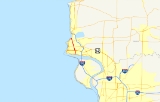
New York State Route 61 (NY 61) is a state highway
located almost entirely in the city of Niagara Falls
in Niagara County
, New York
in the United States
. The road runs across the city in a northwest–southeast direction, terminating at NY 384
at its southern extent and NY 104
at its northern tip. Conceptually, the road, known as Hyde Park Boulevard, forms the eastern border of downtown Niagara Falls. It is the second-shortest two-digit route in New York after NY 71 in Columbia County
. The NY 61 designation was assigned ca. 1962.
(Buffalo Avenue) on the industrial banks of the Niagara River
in eastern Niagara Falls
. The route, named Hyde Park Boulevard for its entire length, heads north initially as a city-maintained, undivided four-lane highway; after two blocks, the roadway widens and becomes maintained by the New York State Department of Transportation
. NY 61 continues onward through the densely populated neighborhoods of Niagara Falls to Packard Road, where the route begins to parallel Gill Creek, a small stream leading south to the Niagara River. After five blocks, NY 61 intersects with Ferry Avenue, a one-way street carrying southbound U.S. Route 62 (US 62), in the area of the Niagara Falls Courthouse. NY 61 intersects with northbound US 62 three blocks later at Walnut Avenue. At the intersection, Gill Creek passes under both US 62 northbound and NY 61 as it switches to the east side of Hyde Park Boulevard.
 Gill Creek and NY 61 continue to run parallel for one more block before they separate ahead of Pine Avenue, once known as NY 62A
and now designated as US 62 Business. The intersection between Pine and Hyde Park Boulevard marks the southwestern limits of Hyde Park, one of the largest parks in the vicinity of the city. For the next dozen blocks, NY 61 acts as the divider between the residential neighborhoods of downtown Niagara Falls and the open spaces of Hyde Park, passing Sal Maglie Stadium
as it heads north. At Linwood Avenue, the homes return to both sides of NY 61 as it approaches Porter Road, which carries NY 182
. While Porter Road ends here, NY 182 turns north, joining NY 61 for two blocks to Ontario Avenue, where NY 182 turns west toward the Whirlpool Rapids Bridge
.
North of Ontario Avenue, the buildings surrounding NY 61 become more commercial and industrial in nature as the route approaches the CSX Transportation
Niagara Yard
. It crosses over the western end of the yard before intersecting Lockport Road. The Niagara Falls Amtrak
station, which Hyde Park Boulevard passes by but provides no access to, is located just off Lockport Road on 27th Street.
Away from the yard, the surroundings become residential once more for another four blocks before entering a heavily industrial neighborhood around an intersection with NY 31
. Farther north in Lewiston
, the center turn lane becomes a hard median as it widens in preparation for a pseudo-interchange with Highland Avenue. The median reverts back to its previous width shortly after Highland merges into Hyde Park Boulevard; however, the median ends two blocks later at a service road for the Robert Moses Niagara Power Plant. NY 61, now a four-lane undivided highway once again, continues for another 0.25 mile (0.402335 km) to the top of the Niagara River gorge, where it ends at NY 104
south of the Moses Power Plant and adjacent to the campus of Niagara University
.
Niagara Yard
, at 355 feet (108.2 m) long, was completed in 1964. It was reconstructed in 1997.
State highway
State highway, state road or state route can refer to one of three related concepts, two of them related to a state or provincial government in a country that is divided into states or provinces :#A...
located almost entirely in the city of Niagara Falls
Niagara Falls, New York
Niagara Falls is a city in Niagara County, New York, United States. As of the 2010 census, the city had a total population of 50,193, down from the 55,593 recorded in the 2000 census. It is across the Niagara River from Niagara Falls, Ontario , both named after the famed Niagara Falls which they...
in Niagara County
Niagara County, New York
Niagara County is a county located in the U.S. state of New York. As of the 2010 census, the population was 216,469. The county seat is Lockport. The county name is from the Iroquois word Onguiaahra; meaning the strait or thunder of waters. It is the location of Niagara Falls and Fort Niagara, and...
, New York
New York
New York is a state in the Northeastern region of the United States. It is the nation's third most populous state. New York is bordered by New Jersey and Pennsylvania to the south, and by Connecticut, Massachusetts and Vermont to the east...
in the United States
United States
The United States of America is a federal constitutional republic comprising fifty states and a federal district...
. The road runs across the city in a northwest–southeast direction, terminating at NY 384
New York State Route 384
New York State Route 384 is a state highway in Western New York in the United States. It is a north–south route extending from the city of Buffalo, Erie County to the city of Niagara Falls, Niagara County, and is one of several routes directly connecting the two cities. The southern terminus...
at its southern extent and NY 104
New York State Route 104
New York State Route 104 is a long east–west state highway in Upstate New York, United States. It spans six counties and enters the vicinity of four cities—Niagara Falls, Lockport, Rochester, and Oswego—as it follows a routing largely parallel to that of the southern shoreline of Lake...
at its northern tip. Conceptually, the road, known as Hyde Park Boulevard, forms the eastern border of downtown Niagara Falls. It is the second-shortest two-digit route in New York after NY 71 in Columbia County
Columbia County, New York
Columbia County is a county located in the U.S. state of New York. As of the 2010 census, the population was 63,096. The county seat is Hudson. The name comes from the Latin feminine form of the name of Christopher Columbus, which was at the time of the formation of the county a popular proposal...
. The NY 61 designation was assigned ca. 1962.
Route description
NY 61 begins at an intersection with NY 384New York State Route 384
New York State Route 384 is a state highway in Western New York in the United States. It is a north–south route extending from the city of Buffalo, Erie County to the city of Niagara Falls, Niagara County, and is one of several routes directly connecting the two cities. The southern terminus...
(Buffalo Avenue) on the industrial banks of the Niagara River
Niagara River
The Niagara River flows north from Lake Erie to Lake Ontario. It forms part of the border between the Province of Ontario in Canada and New York State in the United States. There are differing theories as to the origin of the name of the river...
in eastern Niagara Falls
Niagara Falls, New York
Niagara Falls is a city in Niagara County, New York, United States. As of the 2010 census, the city had a total population of 50,193, down from the 55,593 recorded in the 2000 census. It is across the Niagara River from Niagara Falls, Ontario , both named after the famed Niagara Falls which they...
. The route, named Hyde Park Boulevard for its entire length, heads north initially as a city-maintained, undivided four-lane highway; after two blocks, the roadway widens and becomes maintained by the New York State Department of Transportation
New York State Department of Transportation
The New York State Department of Transportation is responsible for the development and operation of highways, railroads, mass transit systems, ports, waterways and aviation facilities in the U.S...
. NY 61 continues onward through the densely populated neighborhoods of Niagara Falls to Packard Road, where the route begins to parallel Gill Creek, a small stream leading south to the Niagara River. After five blocks, NY 61 intersects with Ferry Avenue, a one-way street carrying southbound U.S. Route 62 (US 62), in the area of the Niagara Falls Courthouse. NY 61 intersects with northbound US 62 three blocks later at Walnut Avenue. At the intersection, Gill Creek passes under both US 62 northbound and NY 61 as it switches to the east side of Hyde Park Boulevard.
New York State Route 62A
U.S. Route 62 Business is a business route of US 62 located within the city of Niagara Falls, New York, in the United States. It follows Pine Avenue through downtown Niagara Falls, spanning between New York State Route 104 at its western terminus and US 62 at its eastern extent...
and now designated as US 62 Business. The intersection between Pine and Hyde Park Boulevard marks the southwestern limits of Hyde Park, one of the largest parks in the vicinity of the city. For the next dozen blocks, NY 61 acts as the divider between the residential neighborhoods of downtown Niagara Falls and the open spaces of Hyde Park, passing Sal Maglie Stadium
Sal Maglie Stadium
Sal Maglie Stadium is a stadium in Niagara Falls, New York. It is primarily used for baseball and was the home of the Niagara Falls Rapids of the New York - Penn League. The ballpark has a capacity of 4,000 people and opened in 1939. Its original name was simply Hyde Park Stadium, and was...
as it heads north. At Linwood Avenue, the homes return to both sides of NY 61 as it approaches Porter Road, which carries NY 182
New York State Route 182
New York State Route 182 is a state highway in Niagara County, New York, United States. It serves as a signed connection between the Whirlpool Rapids Bridge over the Niagara River and the Niagara Falls International Airport east of the city of Niagara Falls...
. While Porter Road ends here, NY 182 turns north, joining NY 61 for two blocks to Ontario Avenue, where NY 182 turns west toward the Whirlpool Rapids Bridge
Whirlpool Rapids Bridge
The Whirlpool Rapids Bridge, commonly called the Whirlpool Bridge, and until 1937, known as the Lower Steel Arch Bridge, is a spandrel braced, riveted, two-hinged arch bridge. It crosses the international border between Canada and the United States, connecting the commercial downtown districts of...
.
North of Ontario Avenue, the buildings surrounding NY 61 become more commercial and industrial in nature as the route approaches the CSX Transportation
CSX Transportation
CSX Transportation operates a Class I railroad in the United States known as the CSX Railroad. It is the main subsidiary of the CSX Corporation. The company is headquartered in Jacksonville, Florida, and owns approximately 21,000 route miles...
Niagara Yard
Classification yard
A classification yard or marshalling yard is a railroad yard found at some freight train stations, used to separate railroad cars on to one of several tracks. First the cars are taken to a track, sometimes called a lead or a drill...
. It crosses over the western end of the yard before intersecting Lockport Road. The Niagara Falls Amtrak
Amtrak
The National Railroad Passenger Corporation, doing business as Amtrak , is a government-owned corporation that was organized on May 1, 1971, to provide intercity passenger train service in the United States. "Amtrak" is a portmanteau of the words "America" and "track". It is headquartered at Union...
station, which Hyde Park Boulevard passes by but provides no access to, is located just off Lockport Road on 27th Street.
Away from the yard, the surroundings become residential once more for another four blocks before entering a heavily industrial neighborhood around an intersection with NY 31
New York State Route 31
New York State Route 31 is a state highway that extends for across western and central New York in the United States. The western terminus of the route is at an intersection with NY 104 in the city of Niagara Falls. Its eastern terminus is at a traffic circle with NY 26 in Vernon...
. Farther north in Lewiston
Lewiston (town), New York
Lewiston is a town in Niagara County, New York United States. The population was 16,262 at the 2010 census. The town and its contained village are named after Morgan Lewis, a governor of New York....
, the center turn lane becomes a hard median as it widens in preparation for a pseudo-interchange with Highland Avenue. The median reverts back to its previous width shortly after Highland merges into Hyde Park Boulevard; however, the median ends two blocks later at a service road for the Robert Moses Niagara Power Plant. NY 61, now a four-lane undivided highway once again, continues for another 0.25 mile (0.402335 km) to the top of the Niagara River gorge, where it ends at NY 104
New York State Route 104
New York State Route 104 is a long east–west state highway in Upstate New York, United States. It spans six counties and enters the vicinity of four cities—Niagara Falls, Lockport, Rochester, and Oswego—as it follows a routing largely parallel to that of the southern shoreline of Lake...
south of the Moses Power Plant and adjacent to the campus of Niagara University
Niagara University
Niagara University is a Catholic university in the Vincentian tradition, located in the Town of Lewiston in Niagara County, New York. Originally founded by the Congregation of the Mission in 1856 as Our Lady of Angels Seminary, it became Niagara University in 1883. The University is still run by...
.
History
NY 61 was assigned ca. 1962 to its current alignment. In that same year, the bridge carrying Hyde Park Boulevard over Gill Creek at Walnut Avenue, 41 feet (12.5 m) in length and originally built in 1950, was reconstructed. Farther north, the bridge over the western end of the CSX TransportationCSX Transportation
CSX Transportation operates a Class I railroad in the United States known as the CSX Railroad. It is the main subsidiary of the CSX Corporation. The company is headquartered in Jacksonville, Florida, and owns approximately 21,000 route miles...
Niagara Yard
Classification yard
A classification yard or marshalling yard is a railroad yard found at some freight train stations, used to separate railroad cars on to one of several tracks. First the cars are taken to a track, sometimes called a lead or a drill...
, at 355 feet (108.2 m) long, was completed in 1964. It was reconstructed in 1997.