
Interstate 81 in New York
Encyclopedia
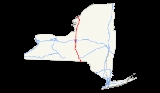
Interstate 81 is a part of the Interstate Highway System
that runs from Dandridge, Tennessee
, to the Canada – United States border at Wellesley Island
in New York
. In the U.S. state
of New York, I-81 extends 183.52 miles (295.35 km) from the Pennsylvania state line southeast of Binghamton
to the Canadian border at Wellesley Island northwest of Alexandria Bay
. I-81 runs north–south through Central New York
, serving the cities of Binghamton, Syracuse
, and Watertown. It passes through the Thousand Islands
in its final miles and crosses two bridges, both part of the series of bridges known as the Thousand Islands Bridge
.
at the Pennsylvania
state line about 11 miles (18 km) south east of Binghamton. I-81 merges with NY 17
for 5 miles (8 km). The current segment of NY 17 is set to become I-86. About 1 miles (1.6 km) north of Binghamton at exit 5, I-81 meets the western terminus of I-88. US 11 has been paralleling I-81 from Virginia
and US 11 will parallel I-81 in most of New York. At mile marker 73 and exit 15, I-81 meets with the longest road in the United States
: US 20
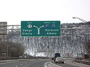
in La Fayette. At the southern tip of Syracuse
, at mile marker 81, and exit 16A, I-81 meets with one of its spurs: I-481. In downtown Syracuse, I-81 meets I-690 at an incomplete interchange.
(Interstate 90) at exit 25A. In North Syracuse
at mile marker 93, I-81 meets with I-481 and NY 481
at exit 29. From exit 36 to exit 48, I-81 parallels Lake Ontario
. Further north, I-81 crosses Thousand Islands Bridge
(toll northbound only) at the U.S./ Canadian
border 6 miles (10 km) north of Fishers Landing.
 Approaching and, further, beyond I-81's northern terminus at the Canadian
border, two toll bridge spans over the St. Lawrence River connect it to Highway 401
(via Highway 137
) in Ontario
. The main bridge span on the United States side is one of the few remaining 2-lane Interstate stretches left on the system. The border itself is marked by a 90 feet (27.4 m) bridge across the International Rift between Wellesley Island, New York
and Hill Island, Ontario
.
proposed constructing four expressways across the state of New York
to supplement the then-under construction New York State Thruway
. One of the four proposed highways began in Binghamton and proceeded generally northward through Central New York
to the Canadian border north of Watertown
. The first section of the highway—from Tully
north to Nedrow
—was completed in the mid-1950s. On August 14, 1957, the entirety of the proposed highway was included in the Interstate Highway System
and designated as part of Interstate 81. Two more sections of the route—between North Syracuse
and Brewerton
and from Adams
to Pamelia
—were opened to traffic in the late 1950s.
C.
1961, the North Syracuse – Brewerton segment of the freeway was extended south into downtown Syracuse
and north to Parish
. Farther north, the section between exits 38 and 40 in southern Jefferson County
was completed around this time. I-81 was opened to traffic from the Pennsylvania state line north to NY 17
in Kirkwood
in mid-1961 while the gap between the Syracuse–Parish and southern Jefferson County segments was filled in late 1961. The freeway was completed between Pierrepont Manor and Adams by the following year, creating a continuous limited-access highway between Syracuse
and Watertown. In the mid-1960s, four more sections of I-81 were opened to traffic, completing all of I-81 within the state except for the portion between NY 221
in Marathon
and NY 26
in Whitney Point
. The Marathon – Whitney Point segment was completed ca. 1968.
, as well as the area's hospitals. The elevated freeway separates the two areas but also hangs over the 15th Ward. The roadway is slowly deteriorating and is due for a reconstruction in the Syracuse area. Originally the reason for the Interstate's elevation was to make travel from downtown area to the university faster. One major reason for the urgency of this effort is the condition of the viaduct
and other bridges located on I-81 between the I-481 interchanges, as well as on I-690 in the vicinity of the I-81/I-690 interchange. Syracuse Common Councillor Van Robinson in 2001 called for the removal of some elevated portions of the section of I-81 that were blocking Upstate Medical University. He stated that the bridge not only presented a problem sectionalizing the Syracuse area, but also it presented a problem for Syracuse University and Upstate Medical University.
The region is set to reach a final decision on the future of I-81. This decision on I-81 will involve many local groups, or stakeholders, in the issue.
In early May 2011, this official process was started by two entities: the New York State Department of Transportation
(NYSDOT) and the Syracuse Metropolitan Transportation Council (SMTC), the region’s metropolitan planning organization
. NYSDOT is responsible for overseeing the process and, eventually, its construction. SMTC consists of member agencies that have a stake in transportation decisions in Central New York
.
NYSDOT has frequently said that they need to change I-81 due to its deteriorating condition. Both parties have yet to reach a decision, but they hope to eventually reach one that is in the best interest for everyone in the greater Syracuse area. In late March 2011, SMTC and NYSDOT announced the formation of the I-81 Community Liaison Committee (CLC). The CLC is made up of representatives from 37 organizations and will give ideas and point out concerns about the future of I-81 in Syracuse.
Interstate Highway System
The Dwight D. Eisenhower National System of Interstate and Defense Highways, , is a network of limited-access roads including freeways, highways, and expressways forming part of the National Highway System of the United States of America...
that runs from Dandridge, Tennessee
Dandridge, Tennessee
Dandridge is a town in Jefferson County, Tennessee, United States. It is the county seat of Jefferson County. It is part of the Morristown, Tennessee Metropolitan Statistical Area....
, to the Canada – United States border at Wellesley Island
Wellesley Island
Wellesley Island in Jefferson County, New York, USA is partially in the Town of Orleans and partially in the Town of Alexandria.-Geography:...
in New York
New York
New York is a state in the Northeastern region of the United States. It is the nation's third most populous state. New York is bordered by New Jersey and Pennsylvania to the south, and by Connecticut, Massachusetts and Vermont to the east...
. In the U.S. state
U.S. state
A U.S. state is any one of the 50 federated states of the United States of America that share sovereignty with the federal government. Because of this shared sovereignty, an American is a citizen both of the federal entity and of his or her state of domicile. Four states use the official title of...
of New York, I-81 extends 183.52 miles (295.35 km) from the Pennsylvania state line southeast of Binghamton
Binghamton, New York
Binghamton is a city in the Southern Tier of New York in the United States. It is near the Pennsylvania border, in a bowl-shaped valley at the confluence of the Susquehanna and Chenango Rivers...
to the Canadian border at Wellesley Island northwest of Alexandria Bay
Alexandria Bay, New York
Alexandria Bay is a village in Jefferson County, New York, United States. The population was 1,080 at the 2010 census.The Village of Alexandria Bay is in the Town of Alexandria.Keewaydin State Park is southeast of the village...
. I-81 runs north–south through Central New York
Central New York
Central New York is a term used to broadly describe the central region of New York State, roughly including the following counties and cities:...
, serving the cities of Binghamton, Syracuse
Syracuse, New York
Syracuse is a city in and the county seat of Onondaga County, New York, United States, the largest U.S. city with the name "Syracuse", and the fifth most populous city in the state. At the 2010 census, the city population was 145,170, and its metropolitan area had a population of 742,603...
, and Watertown. It passes through the Thousand Islands
Thousand Islands
The Thousand Islands is the name of an archipelago of islands that straddle the Canada-U.S. border in the Saint Lawrence River as it emerges from the northeast corner of Lake Ontario. They stretch for about downstream from Kingston, Ontario. The Canadian islands are in the province of Ontario, the...
in its final miles and crosses two bridges, both part of the series of bridges known as the Thousand Islands Bridge
Thousand Islands Bridge
The Thousand Islands Bridge is an international bridge system over the Saint Lawrence River connecting northern New York in the United States with southeastern Ontario in Canada. Constructed in 1937, with additions in 1959, the bridges span the United States-Canada border in the middle of the...
.
Pennsylvania to Syracuse
Interstate 81 enters New YorkNew York
New York is a state in the Northeastern region of the United States. It is the nation's third most populous state. New York is bordered by New Jersey and Pennsylvania to the south, and by Connecticut, Massachusetts and Vermont to the east...
at the Pennsylvania
Pennsylvania
The Commonwealth of Pennsylvania is a U.S. state that is located in the Northeastern and Mid-Atlantic regions of the United States. The state borders Delaware and Maryland to the south, West Virginia to the southwest, Ohio to the west, New York and Ontario, Canada, to the north, and New Jersey to...
state line about 11 miles (18 km) south east of Binghamton. I-81 merges with NY 17
New York State Route 17
New York State Route 17 is a state highway that extends for through the Southern Tier and Downstate regions of New York in the United States...
for 5 miles (8 km). The current segment of NY 17 is set to become I-86. About 1 miles (1.6 km) north of Binghamton at exit 5, I-81 meets the western terminus of I-88. US 11 has been paralleling I-81 from Virginia
Virginia
The Commonwealth of Virginia , is a U.S. state on the Atlantic Coast of the Southern United States. Virginia is nicknamed the "Old Dominion" and sometimes the "Mother of Presidents" after the eight U.S. presidents born there...
and US 11 will parallel I-81 in most of New York. At mile marker 73 and exit 15, I-81 meets with the longest road in the United States
United States
The United States of America is a federal constitutional republic comprising fifty states and a federal district...
: US 20
U.S. Route 20 in New York
U.S. Route 20 is a part of the U.S. Highway System that runs from Newport, Oregon, to Boston, Massachusetts. In the U.S. state of New York, US 20 extends from the Pennsylvania state line at Ripley to the Massachusetts state line in the Berkshire Mountains. US 20 is the longest...
in La Fayette. At the southern tip of Syracuse
Syracuse, New York
Syracuse is a city in and the county seat of Onondaga County, New York, United States, the largest U.S. city with the name "Syracuse", and the fifth most populous city in the state. At the 2010 census, the city population was 145,170, and its metropolitan area had a population of 742,603...
, at mile marker 81, and exit 16A, I-81 meets with one of its spurs: I-481. In downtown Syracuse, I-81 meets I-690 at an incomplete interchange.
Syracuse to Canada
Just north of Syracuse, I-81 meets the New York State ThruwayNew York State Thruway
The New York State Thruway is a system of limited-access highways located within the state of New York in the United States. The system, known officially as the Governor Thomas E. Dewey Thruway for former New York Governor Thomas E. Dewey, is operated by the New York State Thruway Authority and...
(Interstate 90) at exit 25A. In North Syracuse
North Syracuse, New York
North Syracuse is a village in Onondaga County, New York, United States. The population was 6,863 at the 2000 census.The Village of North Syracuse is partly in the Town of Cicero, but is primarily within the Town of Clay. North Syracuse is north of the City of Syracuse.- History :The village was...
at mile marker 93, I-81 meets with I-481 and NY 481
New York State Route 481
New York State Route 481 is a state highway in Central New York in the United States. The southern terminus of the route is at an interchange with Interstate 81 in North Syracuse, where the highway continues southeastward as I-481. Its northern terminus is located at an intersection...
at exit 29. From exit 36 to exit 48, I-81 parallels Lake Ontario
Lake Ontario
Lake Ontario is one of the five Great Lakes of North America. It is bounded on the north and southwest by the Canadian province of Ontario, and on the south by the American state of New York. Ontario, Canada's most populous province, was named for the lake. In the Wyandot language, ontarío means...
. Further north, I-81 crosses Thousand Islands Bridge
Thousand Islands Bridge
The Thousand Islands Bridge is an international bridge system over the Saint Lawrence River connecting northern New York in the United States with southeastern Ontario in Canada. Constructed in 1937, with additions in 1959, the bridges span the United States-Canada border in the middle of the...
(toll northbound only) at the U.S./ Canadian
Canada
Canada is a North American country consisting of ten provinces and three territories. Located in the northern part of the continent, it extends from the Atlantic Ocean in the east to the Pacific Ocean in the west, and northward into the Arctic Ocean...
border 6 miles (10 km) north of Fishers Landing.
Canada
Canada is a North American country consisting of ten provinces and three territories. Located in the northern part of the continent, it extends from the Atlantic Ocean in the east to the Pacific Ocean in the west, and northward into the Arctic Ocean...
border, two toll bridge spans over the St. Lawrence River connect it to Highway 401
Highway 401 (Ontario)
King's Highway 401, also known by its official name as the Macdonald–Cartier Freeway and colloquially as the four-oh-one, is a 400-Series Highway in the Canadian province of Ontario stretching from Windsor to the Quebec border...
(via Highway 137
Highway 137 (Ontario)
King's Highway 137, also known as Highway 137, is a provincially maintained highway in the Canadian province of Ontario which serves to connect the northern end of Interstate 81 in New York with Highway 401, via the Canadian span of the Thousand Islands Bridge...
) in Ontario
Ontario
Ontario is a province of Canada, located in east-central Canada. It is Canada's most populous province and second largest in total area. It is home to the nation's most populous city, Toronto, and the nation's capital, Ottawa....
. The main bridge span on the United States side is one of the few remaining 2-lane Interstate stretches left on the system. The border itself is marked by a 90 feet (27.4 m) bridge across the International Rift between Wellesley Island, New York
Wellesley Island
Wellesley Island in Jefferson County, New York, USA is partially in the Town of Orleans and partially in the Town of Alexandria.-Geography:...
and Hill Island, Ontario
Ontario
Ontario is a province of Canada, located in east-central Canada. It is Canada's most populous province and second largest in total area. It is home to the nation's most populous city, Toronto, and the nation's capital, Ottawa....
.
History
In February 1953, New York Governor Thomas DeweyThomas Dewey
Thomas Edmund Dewey was the 47th Governor of New York . In 1944 and 1948, he was the Republican candidate for President, but lost both times. He led the liberal faction of the Republican Party, in which he fought conservative Ohio Senator Robert A. Taft...
proposed constructing four expressways across the state of New York
New York
New York is a state in the Northeastern region of the United States. It is the nation's third most populous state. New York is bordered by New Jersey and Pennsylvania to the south, and by Connecticut, Massachusetts and Vermont to the east...
to supplement the then-under construction New York State Thruway
New York State Thruway
The New York State Thruway is a system of limited-access highways located within the state of New York in the United States. The system, known officially as the Governor Thomas E. Dewey Thruway for former New York Governor Thomas E. Dewey, is operated by the New York State Thruway Authority and...
. One of the four proposed highways began in Binghamton and proceeded generally northward through Central New York
Central New York
Central New York is a term used to broadly describe the central region of New York State, roughly including the following counties and cities:...
to the Canadian border north of Watertown
Watertown (city), New York
Watertown is a city in the state of New York and the county seat of Jefferson County. It is situated approximately south of the Thousand Islands. As of the 2010 census, it had a population of 27,023, an increase of 1.2% since 2000. The U.S...
. The first section of the highway—from Tully
Tully (village), New York
Tully is a village in Onondaga County, New York, USA. The population was 924 at the 2000 census. The name of the village is derived from the Roman orator Marcus Tullius Cicero....
north to Nedrow
Nedrow, New York
Nedrow is a hamlet located in the Town of Onondaga in Onondaga County, New York. The population was 2,265 at the 2000 census.-Geography:Nedrow is located at , on US Route 11, south of Syracuse, New York...
—was completed in the mid-1950s. On August 14, 1957, the entirety of the proposed highway was included in the Interstate Highway System
Interstate Highway System
The Dwight D. Eisenhower National System of Interstate and Defense Highways, , is a network of limited-access roads including freeways, highways, and expressways forming part of the National Highway System of the United States of America...
and designated as part of Interstate 81. Two more sections of the route—between North Syracuse
North Syracuse, New York
North Syracuse is a village in Onondaga County, New York, United States. The population was 6,863 at the 2000 census.The Village of North Syracuse is partly in the Town of Cicero, but is primarily within the Town of Clay. North Syracuse is north of the City of Syracuse.- History :The village was...
and Brewerton
Brewerton, New York
Brewerton is a census-designated place in the town of Cicero in Onondaga County and the town of Hastings in Oswego County in the U.S. state of New York. It lies at the west end of Oneida Lake at its outlet into the Oneida River. The population was 3,455 at the 2000 census...
and from Adams
Adams (village), New York
Adams is a village located in the Town of Adams in Jefferson County, New York, USA. The population was 1,624 at the 2000 census. The village is named after President John Adams....
to Pamelia
Pamelia, New York
Pamelia is a town in Jefferson County, New York, United States. The population was 3,160 at the 2010 census. The town is named after Pamelia Williams, the wife of a landowner and developer....
—were opened to traffic in the late 1950s.
C.
Circa
Circa , usually abbreviated c. or ca. , means "approximately" in the English language, usually referring to a date...
1961, the North Syracuse – Brewerton segment of the freeway was extended south into downtown Syracuse
Downtown Syracuse
Downtown Syracuse is the economic center of Syracuse, New York, and Central New York, employing over 30,000 people, and housing over 2,000. It is also one of the 26 officially recognized neighborhoods of Syracuse.- History :...
and north to Parish
Parish (village), New York
Parish is a village in Oswego County, New York, United States. The population was 512 as of the census of 2000.-Geography:Parish is located at ....
. Farther north, the section between exits 38 and 40 in southern Jefferson County
Jefferson County, New York
Jefferson County is a county located in the U.S. state of New York. As of the 2010 census, the population was 116,229. It is named after Thomas Jefferson, third President of the United States of America, and president at the time the county was created in 1805...
was completed around this time. I-81 was opened to traffic from the Pennsylvania state line north to NY 17
New York State Route 17
New York State Route 17 is a state highway that extends for through the Southern Tier and Downstate regions of New York in the United States...
in Kirkwood
Kirkwood, New York
Kirkwood is a town in Broome County, New York, United States. The population was 5,651 at the 2000 census. The town is named after James P. Kirkwood, who was an engineer responsible for constructing the local railroad....
in mid-1961 while the gap between the Syracuse–Parish and southern Jefferson County segments was filled in late 1961. The freeway was completed between Pierrepont Manor and Adams by the following year, creating a continuous limited-access highway between Syracuse
Syracuse, New York
Syracuse is a city in and the county seat of Onondaga County, New York, United States, the largest U.S. city with the name "Syracuse", and the fifth most populous city in the state. At the 2010 census, the city population was 145,170, and its metropolitan area had a population of 742,603...
and Watertown. In the mid-1960s, four more sections of I-81 were opened to traffic, completing all of I-81 within the state except for the portion between NY 221
New York State Route 221
New York State Route 221 is a state highway in Cortland County, New York, United States. Its western terminus is at NY 38 in the town of Harford. The eastern terminus is at NY 26 and NY 41 in the town of Willet. Near its western end, NY 221 intersects New York State...
in Marathon
Marathon (village), New York
Marathon is a village in Cortland County, New York, USA. The population was 1,063 at the 2000 census.The Village of Marathon is within the Town of Marathon.- History :The village is within the former Central New York Military Tract....
and NY 26
New York State Route 26
New York State Route 26 is a north–south state highway that runs for through Central New York in the United States. Its southern terminus is located at the Pennsylvania state line south of the town of Vestal in Broome County, where it becomes Pennsylvania Route 267...
in Whitney Point
Whitney Point, New York
Whitney Point is a village in Broome County, New York, United States. The population was 965 at the 2000 census. It is part of the Binghamton Metropolitan Statistical Area...
. The Marathon – Whitney Point segment was completed ca. 1968.
Controversy around Syracuse
As I-81 runs through Syracuse it separates the 15th Ward and Syracuse UniversitySyracuse University
Syracuse University is a private research university located in Syracuse, New York, United States. Its roots can be traced back to Genesee Wesleyan Seminary, founded by the Methodist Episcopal Church in 1832, which also later founded Genesee College...
, as well as the area's hospitals. The elevated freeway separates the two areas but also hangs over the 15th Ward. The roadway is slowly deteriorating and is due for a reconstruction in the Syracuse area. Originally the reason for the Interstate's elevation was to make travel from downtown area to the university faster. One major reason for the urgency of this effort is the condition of the viaduct
Viaduct
A viaduct is a bridge composed of several small spans. The term viaduct is derived from the Latin via for road and ducere to lead something. However, the Ancient Romans did not use that term per se; it is a modern derivation from an analogy with aqueduct. Like the Roman aqueducts, many early...
and other bridges located on I-81 between the I-481 interchanges, as well as on I-690 in the vicinity of the I-81/I-690 interchange. Syracuse Common Councillor Van Robinson in 2001 called for the removal of some elevated portions of the section of I-81 that were blocking Upstate Medical University. He stated that the bridge not only presented a problem sectionalizing the Syracuse area, but also it presented a problem for Syracuse University and Upstate Medical University.
The region is set to reach a final decision on the future of I-81. This decision on I-81 will involve many local groups, or stakeholders, in the issue.
In early May 2011, this official process was started by two entities: the New York State Department of Transportation
New York State Department of Transportation
The New York State Department of Transportation is responsible for the development and operation of highways, railroads, mass transit systems, ports, waterways and aviation facilities in the U.S...
(NYSDOT) and the Syracuse Metropolitan Transportation Council (SMTC), the region’s metropolitan planning organization
Metropolitan planning organization
A metropolitan planning organization is a federally-mandated and federally-funded transportation policy-making organization in the United States that is made up of representatives from local government and governmental transportation authorities...
. NYSDOT is responsible for overseeing the process and, eventually, its construction. SMTC consists of member agencies that have a stake in transportation decisions in Central New York
Central New York
Central New York is a term used to broadly describe the central region of New York State, roughly including the following counties and cities:...
.
NYSDOT has frequently said that they need to change I-81 due to its deteriorating condition. Both parties have yet to reach a decision, but they hope to eventually reach one that is in the best interest for everyone in the greater Syracuse area. In late March 2011, SMTC and NYSDOT announced the formation of the I-81 Community Liaison Committee (CLC). The CLC is made up of representatives from 37 organizations and will give ideas and point out concerns about the future of I-81 in Syracuse.