
Niagara County, New York
Encyclopedia
Niagara County is a county located in the U.S. state
of New York
. As of the 2010 census, the population was 216,469. The county seat
is Lockport
. The county name is from the Iroquois
word Onguiaahra; meaning the strait or thunder of waters. It is the location of Niagara Falls
and Fort Niagara
, and has many parks and lake shore recreation communities. In the Summer of 2008 Niagara County celebrated its 200th Birthday with the first town of the county, Town of Cambria.
Niagara County is part of the Buffalo
–Niagara Falls Metropolitan Statistical Area
.
. This was an enormous county, including the northern part of New York State as well as all of the present State of Vermont
and, in theory, extending westward to the Pacific Ocean
. This county was reduced in size on July 3, 1766 by the creation of Cumberland County
, and further on March 16, 1770 by the creation of Gloucester County
, both containing territory now in Vermont.
On March 12, 1772, what was left of Albany County was split into three parts, one remaining under the name Albany County. One of the other pieces, Tryon County
, contained the western portion (and thus, since no western boundary was specified, theoretically still extended west to the Pacific). The eastern boundary of Tryon County was approximately five miles west of the present city of Schenectady
, and the county included the western part of the Adirondack Mountains
and the area west of the West Branch of the Delaware River
. The area then designated as Tryon County now includes 37 counties of New York State. The county was named for William Tryon
, colonial governor of New York.
In the years prior to 1776, most of the Loyalists in Tryon County fled to Canada
. In 1784, following the peace treaty that ended the American Revolutionary War
, the name of Tryon County was changed to honor the general, Richard Montgomery
, who had captured several places in Canada and died attempting to capture the city of Quebec
, replacing the name of the hated British governor.
In 1789, Ontario County
was split off from Montgomery. In turn, Genesee County
was created from Ontario County in 1802.
Niagara County was created from Genesee County in 1808. It was, however, larger than the present Niagara County even though it consisted of only the Town of Cambria.
From 1814 to 1817, records of Cattaraugus County
were divided between Belmont
(the seat
of Allegany County
) and Buffalo
(then in Niagara County).
In 1821, Erie County
was created from Niagara County.
The county has a number of properties on the National Register of Historic Places.
and adjacent to Lake Ontario
on its northern border and the Niagara River
and Canada
on its western border. The border results in a number of ongoing Illegal Immigration
cases, though these crimes are more common to the east where the border is across land rather than a surface water body.
The primary geographic feature of the county is Niagara Falls
, the riverbed of which has eroded seven miles south over the past 12,000 years since the last Ice Age
. The Niagara River and Niagara Falls, are in effect, the drainage ditch for four of the Great Lakes
which constitute the largest supply of fresh water
in the world. The water flows north from Lake Erie
, then through the Niagara River, goes over Niagara Falls, and then on to Lake Ontario and the St. Lawrence River, eventually emptying into the North Atlantic Ocean. Today, tourists and visitors to the Falls only see half of the natural water flow over the Falls, since the other half has been taken for hydroelectric power purposes. Both the American and Canadian side of the Niagara River have massive electrical power plants.
The spectacular Niagara Gorge is the path Niagara Falls has taken over thousands of years as it continues to erode. Niagara Falls started at the Niagara Escarpment which cuts Niagara County in half in an East-West direction. North of the Escarpment lies the Lake Ontario plain, which is a fertile flatland that is used to grow grapes, apples, peaches and other fruits and vegetables. Viticulture
, or wine culture has begun to take place, with several wineries below the escarpment. This has helped to improve the depressed economy of the region. To further capitalize on economic development, the state has created the Niagara Wine Trail.
According to the U.S. Census Bureau
, the county has a total area of 1140 square miles (2,952.6 km²), of which 523 square miles (1,354.6 km²) is land and 617 square miles (1,598 km²) (54.12%) is water.
, with the Chairman of the Legislature as the de facto head of county government. Currently, there are 15 members of the Republican-led Majority Caucus and 2 members of the Democrat-led Minority Caucus, with two non-aligned Democrats. The Legislature is set to be downsized to 15 seats effective January 1, 2012.
A subordinate county manager reports to the County Legislature. Jeffrey M. Glatz is Niagara County Manager, with a four-year term commencing December 1, 2010.
Legislator Giulio Colangelo (1st District—City of Niagara Falls
)
Legislator Renae Kimble (2nd District—City of Niagara Falls
)
Legislator Kari Ann Bullman (3rd District—City of Niagara Falls
)
Legislator Dennis F. Virtuoso (4th District—City of Niagara Falls
)
Legislator Cheree J. Copelin (5th District—LaSalle/City of Niagara Falls
)
Legislator Brittany Catchpole (6th District—Town of Niagara
)
Legislator Gerald K. Farnham (7th District—Towns of Lockport
and Pendleton
)
Legislator William L. Ross (8th District—Town of Wheatfield
)
Legislator Phillip R. "Russ" Rizzo (9th District—City of North Tonawanda
)
Legislator Peter E. Smolinski (10th District—City of North Tonawanda
)
Legislator Paul B. Wojtaszek (11th District—City of North Tonawanda
)
Legislator Richard F. Soluri (12th District—Town of Lewiston
)
Legislator Clyde L. Burmaster (13th District—Towns of Lewiston
and Porter
)
Legislator David E. Godfrey (14th District—Towns of Cambria
and Wilson
)
Legislator Anthony J. Nemi (15th District—City of Lockport
)
Legislator Wm. Keith McNall (16th District—City of Lockport
)
Legislator Richard E. Updegrove (17th District—Town of Lockport
)
Legislator John Syracuse (18th District—Towns of Newfane
and Somerset
)
Legislator Michael A. Hill (19th District—Towns of Royalton
and Hartland
)
Governing functions of the Legislature rely on a committee
system; currently, there are five standing committees and one long-term ad hoc committee. The five standing committees are Administration, chaired by McNall; Community Services, chaired by Smolinski; Community Safety and Security, chaired by Wojtaszek; Economic Development, chaired by Updegrove; and Public Works, chaired by Burmaster. An ad hoc Refuse Disposal District Committee is chaired by Farnham.
The Administration Committee has oversight of the following government departments: County Manager, County Attorney, Management & Budget, Treasurer, Audit, Real Property, Data Processing, Legislature Office, Printing/Mailing, Human Resources, Civil Service, Risk Management, and Board of Elections.
The Community Services Committee has oversight of the following government departments: Social Services, Employment & Training, Youth Bureau, Office of Aging, Public Health, Mental Health, NCCC, County Clerk/DMV, Historian, and Veterans Services.
The Community Safety and Security Committee has oversight of the following government departments: Sheriff, District Attorney, Public Defender, Probation, Fire Coordinator/Emergency Services, and Coroners.
The Economic Development Committee has oversight of the Niagara County Center for Economic Development and the Niagara County Industrial Development Agency.
The Public Works Committee has oversight of the following government departments: Public Works, Parks/Golf Course, Refuse Disposal District, Sewer District, Water District, and Weights & Measures.
Additionally, the ad hoc Refuse Disposal District Committee has oversight of that District.
, which is ancestrally the dominant party in Niagara County. However, the Majority Caucus which controls 15 seats in the Legislature includes one member of the New York State Conservative Party and two members of the New York State Independence Party
. The Minority Caucus, meanwhile, is composed entirely of members of the Democratic Party
.
Treasurer Kyle R. Andrews (D)
Sheriff James R. Voutour (D)
District Attorney (R)
Coroner, 1st District Cindy Lou Joyce (D)
Coroner, 2nd District Joseph V. Mantione (R)
Coroner, 3rd District Kenneth V. Lederhouse (R) Lederhouse is also the senior coroner, having served longest of the four county coroners.
Coroner, 4th District Robert W. DuBois (D)
of 2010, there were 216,469 people, 87,846 households, and 58,593 families residing in the county. The population density
was 420 people per square mile (162/km²). There were 95,715 housing units at an average density of 183 per square mile (71/km²). The racial makeup of the county was 90.70% White
, 6.15% Black
or African American
, 0.94% Native American
, 0.58% Asian
, 0.02% Pacific Islander
, 0.40% from other races
, and 1.21% from two or more races. 1.33% of the population were Hispanic
or Latino
of any race. 23.6% were of German
, 18.1% Italian
, 11.3% Irish
, 11.2% Polish and 8.3% English
ancestry according to Census 2000. 94.5% spoke English
, 1.6% Spanish
and 1.0% Italian
as their first language.
There were 87,846 households out of which 30.90% had children under the age of 18 living with them, 50.30% were married couples
living together, 12.30% had a female householder with no husband present, and 33.30% were non-families. 28.60% of all households were made up of individuals and 12.00% had someone living alone who was 65 years of age or older. The average household size was 2.45 and the average family size was 3.03.
In the county the population was spread out with 24.70% under the age of 18, 8.50% from 18 to 24, 28.40% from 25 to 44, 23.10% from 45 to 64, and 15.40% who were 65 years of age or older. The median age was 38 years. For every 100 females there were 93.30 males. For every 100 females age 18 and over, there were 89.50 males.
The median income for a household in the county was $38,136, and the median income for a family was $47,817. Males had a median income of $37,468 versus $24,668 for females. The per capita income
for the county was $19,219. About 8.20% of families and 10.60% of the population were below the poverty line, including 15.00% of those under age 18 and 7.30% of those age 65 or over.
is located in Lewiston, New York. Niagara County Community College
is located in Sanborn
, New York
. Many Niagara County residents also attend Erie
and other Western New York
County Schools.
In the Buffalo
Metro area there more than 20 public and private colleges and universities in Buffalo and its environs offer programs in technical and vocational
training, graduate, and professional studies.
U.S. state
A U.S. state is any one of the 50 federated states of the United States of America that share sovereignty with the federal government. Because of this shared sovereignty, an American is a citizen both of the federal entity and of his or her state of domicile. Four states use the official title of...
of New York
New York
New York is a state in the Northeastern region of the United States. It is the nation's third most populous state. New York is bordered by New Jersey and Pennsylvania to the south, and by Connecticut, Massachusetts and Vermont to the east...
. As of the 2010 census, the population was 216,469. The county seat
County seat
A county seat is an administrative center, or seat of government, for a county or civil parish. The term is primarily used in the United States....
is Lockport
Lockport (city), New York
Lockport is a city in Niagara County, New York, United States. The population was 21,165 at the 2010 census. The name is derived from a set of Erie canal locks within the city. Lockport is the county seat of Niagara County and is surrounded by the town of Lockport...
. The county name is from the Iroquois
Iroquois
The Iroquois , also known as the Haudenosaunee or the "People of the Longhouse", are an association of several tribes of indigenous people of North America...
word Onguiaahra; meaning the strait or thunder of waters. It is the location of Niagara Falls
Niagara Falls
The Niagara Falls, located on the Niagara River draining Lake Erie into Lake Ontario, is the collective name for the Horseshoe Falls and the adjacent American Falls along with the comparatively small Bridal Veil Falls, which combined form the highest flow rate of any waterfalls in the world and has...
and Fort Niagara
Fort Niagara
Fort Niagara is a fortification originally built to protect the interests of New France in North America. It is located near Youngstown, New York, on the eastern bank of the Niagara River at its mouth, on Lake Ontario.-Origin:...
, and has many parks and lake shore recreation communities. In the Summer of 2008 Niagara County celebrated its 200th Birthday with the first town of the county, Town of Cambria.
Cambria, New York
Cambria is a town in Niagara County, New York, USA. The population was 5,839 at the 2010 census. Cambria is an early name for Wales.The Town of Cambria is in the center of Niagara County.New York State Route 93 passes through the town.- History :...
Niagara County is part of the Buffalo
Buffalo, New York
Buffalo is the second most populous city in the state of New York, after New York City. Located in Western New York on the eastern shores of Lake Erie and at the head of the Niagara River across from Fort Erie, Ontario, Buffalo is the seat of Erie County and the principal city of the...
–Niagara Falls Metropolitan Statistical Area
Buffalo-Niagara Falls metropolitan area
The Buffalo-Niagara Falls Metropolitan Statistical Area is a metropolitan area, designated by the United States Census Bureau, encompassing two counties – Erie and Niagara – in Western New York, with a population, as of the 2010 census, of 1,135,509 inhabitants...
.
History
When counties were established in the New York colony in 1683, the present Niagara County was part of Albany CountyAlbany County, New York
Albany County is a county located in the U.S. state of New York, and is part of the Albany-Schenectady-Troy Metropolitan Statistical Area. The name is from the title of the Duke of York and Albany, who became James II of England . As of the 2010 census, the population was 304,204...
. This was an enormous county, including the northern part of New York State as well as all of the present State of Vermont
Vermont
Vermont is a state in the New England region of the northeastern United States of America. The state ranks 43rd in land area, , and 45th in total area. Its population according to the 2010 census, 630,337, is the second smallest in the country, larger only than Wyoming. It is the only New England...
and, in theory, extending westward to the Pacific Ocean
Pacific Ocean
The Pacific Ocean is the largest of the Earth's oceanic divisions. It extends from the Arctic in the north to the Southern Ocean in the south, bounded by Asia and Australia in the west, and the Americas in the east.At 165.2 million square kilometres in area, this largest division of the World...
. This county was reduced in size on July 3, 1766 by the creation of Cumberland County
Cumberland County, New York
Cumberland County, New York was a county in the Province of New York that became part of the state of Vermont. It was divided out of Albany County in New York in 1766, but eventually became part of Vermont in 1777...
, and further on March 16, 1770 by the creation of Gloucester County
Gloucester County, New York
Gloucester County, New York is a former county in New York that became part of the state of Vermont. It was a part of Albany County in the Province of New York until 1770 and was lost to Vermont in 1777. At that time, Vermont was holding itself out as the Republic of Vermont and did not become a...
, both containing territory now in Vermont.
On March 12, 1772, what was left of Albany County was split into three parts, one remaining under the name Albany County. One of the other pieces, Tryon County
Tryon County, New York
Tryon County, New York was a county in the colonial Province of New York in the British American colonies. It was created from Albany County on March 24, 1772. It was named for William Tryon, the last provincial governor of New York. Its boundaries extended far further than any current county...
, contained the western portion (and thus, since no western boundary was specified, theoretically still extended west to the Pacific). The eastern boundary of Tryon County was approximately five miles west of the present city of Schenectady
Schenectady, New York
Schenectady is a city in Schenectady County, New York, United States, of which it is the county seat. As of the 2010 census, the city had a population of 66,135...
, and the county included the western part of the Adirondack Mountains
Adirondack Mountains
The Adirondack Mountains are a mountain range located in the northeastern part of New York, that runs through Clinton, Essex, Franklin, Fulton, Hamilton, Herkimer, Lewis, Saint Lawrence, Saratoga, Warren, and Washington counties....
and the area west of the West Branch of the Delaware River
Delaware River
The Delaware River is a major river on the Atlantic coast of the United States.A Dutch expedition led by Henry Hudson in 1609 first mapped the river. The river was christened the South River in the New Netherland colony that followed, in contrast to the North River, as the Hudson River was then...
. The area then designated as Tryon County now includes 37 counties of New York State. The county was named for William Tryon
William Tryon
William Tryon was a British soldier and colonial administrator who served as governor of the Province of North Carolina and the Province of New York .-Early life and career:...
, colonial governor of New York.
In the years prior to 1776, most of the Loyalists in Tryon County fled to Canada
Canada
Canada is a North American country consisting of ten provinces and three territories. Located in the northern part of the continent, it extends from the Atlantic Ocean in the east to the Pacific Ocean in the west, and northward into the Arctic Ocean...
. In 1784, following the peace treaty that ended the American Revolutionary War
American Revolutionary War
The American Revolutionary War , the American War of Independence, or simply the Revolutionary War, began as a war between the Kingdom of Great Britain and thirteen British colonies in North America, and ended in a global war between several European great powers.The war was the result of the...
, the name of Tryon County was changed to honor the general, Richard Montgomery
Richard Montgomery
Richard Montgomery was an Irish-born soldier who first served in the British Army. He later became a brigadier-general in the Continental Army during the American Revolutionary War and he is most famous for leading the failed 1775 invasion of Canada.Montgomery was born and raised in Ireland...
, who had captured several places in Canada and died attempting to capture the city of Quebec
Quebec
Quebec or is a province in east-central Canada. It is the only Canadian province with a predominantly French-speaking population and the only one whose sole official language is French at the provincial level....
, replacing the name of the hated British governor.
In 1789, Ontario County
Ontario County, New York
As of the census of 2000, there were 100,224 people, 38,370 households, and 26,360 families residing in the county. The population density was 156 people per square mile . There were 42,647 housing units at an average density of 66 per square mile...
was split off from Montgomery. In turn, Genesee County
Genesee County, New York
Genesee County is a county located in Western New York, United States. As of the 2010 census, the population was 60,079. Its name is from the Seneca Indian word Gen-nis'-hee-yo meaning "The Beautiful Valley." Its county seat is Batavia.- History :...
was created from Ontario County in 1802.
Niagara County was created from Genesee County in 1808. It was, however, larger than the present Niagara County even though it consisted of only the Town of Cambria.
From 1814 to 1817, records of Cattaraugus County
Cattaraugus County, New York
Cattaraugus County is a county located in the U.S. state of New York. As of the 2010 census, the population was 80,317. The county seat is Little Valley.-History:...
were divided between Belmont
Belmont, New York
Belmont is a village within the Town of Amity which is in Allegany County, New York, USA. Belmont is the county seat of Allegany County. The population was 952 at the 2000 census. The name means beautiful hill....
(the seat
County seat
A county seat is an administrative center, or seat of government, for a county or civil parish. The term is primarily used in the United States....
of Allegany County
Allegany County, New York
Allegany County is a county located in the U.S. state of New York. As of the 2010 census, the population was 48,946. Its name derives from a Delaware Indian word, applied by settlers of Western New York State to a trail that followed the Allegheny River. Its county seat is...
) and Buffalo
Buffalo, New York
Buffalo is the second most populous city in the state of New York, after New York City. Located in Western New York on the eastern shores of Lake Erie and at the head of the Niagara River across from Fort Erie, Ontario, Buffalo is the seat of Erie County and the principal city of the...
(then in Niagara County).
In 1821, Erie County
Erie County, New York
Erie County is a county located in the U.S. state of New York. As of the 2010 census, the population was 919,040. The county seat is Buffalo. The county's name comes from Lake Erie, which in turn comes from the Erie tribe of American Indians who lived south and east of the lake before 1654.Erie...
was created from Niagara County.
The county has a number of properties on the National Register of Historic Places.
Geography
Niagara County is in the extreme western part of New York State, just north of BuffaloBuffalo, New York
Buffalo is the second most populous city in the state of New York, after New York City. Located in Western New York on the eastern shores of Lake Erie and at the head of the Niagara River across from Fort Erie, Ontario, Buffalo is the seat of Erie County and the principal city of the...
and adjacent to Lake Ontario
Lake Ontario
Lake Ontario is one of the five Great Lakes of North America. It is bounded on the north and southwest by the Canadian province of Ontario, and on the south by the American state of New York. Ontario, Canada's most populous province, was named for the lake. In the Wyandot language, ontarío means...
on its northern border and the Niagara River
Niagara River
The Niagara River flows north from Lake Erie to Lake Ontario. It forms part of the border between the Province of Ontario in Canada and New York State in the United States. There are differing theories as to the origin of the name of the river...
and Canada
Canada
Canada is a North American country consisting of ten provinces and three territories. Located in the northern part of the continent, it extends from the Atlantic Ocean in the east to the Pacific Ocean in the west, and northward into the Arctic Ocean...
on its western border. The border results in a number of ongoing Illegal Immigration
Illegal immigration
Illegal immigration is the migration into a nation in violation of the immigration laws of that jurisdiction. Illegal immigration raises many political, economical and social issues and has become a source of major controversy in developed countries and the more successful developing countries.In...
cases, though these crimes are more common to the east where the border is across land rather than a surface water body.
The primary geographic feature of the county is Niagara Falls
Niagara Falls
The Niagara Falls, located on the Niagara River draining Lake Erie into Lake Ontario, is the collective name for the Horseshoe Falls and the adjacent American Falls along with the comparatively small Bridal Veil Falls, which combined form the highest flow rate of any waterfalls in the world and has...
, the riverbed of which has eroded seven miles south over the past 12,000 years since the last Ice Age
Ice age
An ice age or, more precisely, glacial age, is a generic geological period of long-term reduction in the temperature of the Earth's surface and atmosphere, resulting in the presence or expansion of continental ice sheets, polar ice sheets and alpine glaciers...
. The Niagara River and Niagara Falls, are in effect, the drainage ditch for four of the Great Lakes
Great Lakes
The Great Lakes are a collection of freshwater lakes located in northeastern North America, on the Canada – United States border. Consisting of Lakes Superior, Michigan, Huron, Erie, and Ontario, they form the largest group of freshwater lakes on Earth by total surface, coming in second by volume...
which constitute the largest supply of fresh water
Fresh Water
Fresh Water is the debut album by Australian rock and blues singer Alison McCallum, released in 1972. Rare for an Australian artist at the time, it came in a gatefold sleeve...
in the world. The water flows north from Lake Erie
Lake Erie
Lake Erie is the fourth largest lake of the five Great Lakes in North America, and the tenth largest globally. It is the southernmost, shallowest, and smallest by volume of the Great Lakes and therefore also has the shortest average water residence time. It is bounded on the north by the...
, then through the Niagara River, goes over Niagara Falls, and then on to Lake Ontario and the St. Lawrence River, eventually emptying into the North Atlantic Ocean. Today, tourists and visitors to the Falls only see half of the natural water flow over the Falls, since the other half has been taken for hydroelectric power purposes. Both the American and Canadian side of the Niagara River have massive electrical power plants.
The spectacular Niagara Gorge is the path Niagara Falls has taken over thousands of years as it continues to erode. Niagara Falls started at the Niagara Escarpment which cuts Niagara County in half in an East-West direction. North of the Escarpment lies the Lake Ontario plain, which is a fertile flatland that is used to grow grapes, apples, peaches and other fruits and vegetables. Viticulture
Viticulture
Viticulture is the science, production and study of grapes which deals with the series of events that occur in the vineyard. When the grapes are used for winemaking, it is also known as viniculture...
, or wine culture has begun to take place, with several wineries below the escarpment. This has helped to improve the depressed economy of the region. To further capitalize on economic development, the state has created the Niagara Wine Trail.
According to the U.S. Census Bureau
United States Census Bureau
The United States Census Bureau is the government agency that is responsible for the United States Census. It also gathers other national demographic and economic data...
, the county has a total area of 1140 square miles (2,952.6 km²), of which 523 square miles (1,354.6 km²) is land and 617 square miles (1,598 km²) (54.12%) is water.
Adjacent counties and areas
- Orleans CountyOrleans County, New YorkAs of the census of 2000, there were 44,171 people, 15,363 households, and 10,846 families residing in the county. The population density was 113 people per square mile . There were 17,347 housing units at an average density of 44 per square mile...
- east - Genesee CountyGenesee County, New YorkGenesee County is a county located in Western New York, United States. As of the 2010 census, the population was 60,079. Its name is from the Seneca Indian word Gen-nis'-hee-yo meaning "The Beautiful Valley." Its county seat is Batavia.- History :...
- southeast - Erie CountyErie County, New YorkErie County is a county located in the U.S. state of New York. As of the 2010 census, the population was 919,040. The county seat is Buffalo. The county's name comes from Lake Erie, which in turn comes from the Erie tribe of American Indians who lived south and east of the lake before 1654.Erie...
- south - Regional Municipality of Niagara, OntarioRegional Municipality of Niagara, OntarioThe Regional Municipality of Niagara , also known as the Niagara Region, or, colloquially, "Regional Niagara", is a regional municipality comprising twelve municipalities of Southern Ontario, Canada....
, CanadaCanadaCanada is a North American country consisting of ten provinces and three territories. Located in the northern part of the continent, it extends from the Atlantic Ocean in the east to the Pacific Ocean in the west, and northward into the Arctic Ocean...
- west
Major highways
 Interstate 190Interstate 190 (New York)Interstate 190 runs 28.34 miles from Interstate 90 near Buffalo, New York to Lewiston, New York via Niagara Falls. Parts of this highway were built on the former rights-of-way of the Lehigh Valley Railroad and the Erie Canal. It is referred to by locals as The One-Ninety...
(Niagara Thruway) U.S. Route 62U.S. Route 62U.S. Route 62 runs from the US-Mexico border at El Paso, Texas to Niagara Falls, New York, near the United States-Canada border. It is the only east-west US Route that connects Mexico and Canada.Parts of U.S...
 US 62 Business
 New York State Route 18New York State Route 18New York State Route 18 is an east–west state highway in western New York in the United States. It runs parallel to the south shore of Lake Ontario for most of its length between Niagara County and Monroe County...
 New York State Route 31New York State Route 31New York State Route 31 is a state highway that extends for across western and central New York in the United States. The western terminus of the route is at an intersection with NY 104 in the city of Niagara Falls. Its eastern terminus is at a traffic circle with NY 26 in Vernon...
 New York State Route 78New York State Route 78New York State Route 78 , most commonly known as Transit Road, is a state highway in Western New York, USA. While it is signed north–south, the lower portion runs in an east–west direction across Wyoming County, from its beginning north of the Village of Gainesville.NY 78 is...
 New York State Route 93New York State Route 93New York State Route 93 is a state highway in western New York in the United States. It runs in a northwest–southeast direction between NY 18F near the Niagara River in the village of Youngstown and NY 5 just south of the village of Akron...
 New York State Route 104New York State Route 104New York State Route 104 is a long east–west state highway in Upstate New York, United States. It spans six counties and enters the vicinity of four cities—Niagara Falls, Lockport, Rochester, and Oswego—as it follows a routing largely parallel to that of the southern shoreline of Lake...
 New York State Route 265New York State Route 265New York State Route 265 is a state highway located in the western part of New York in the United States. NY 265 is a north–south route that roughly parallels the western parts of the Niagara River in Erie County and Niagara County...
 New York State Route 384New York State Route 384New York State Route 384 is a state highway in Western New York in the United States. It is a north–south route extending from the city of Buffalo, Erie County to the city of Niagara Falls, Niagara County, and is one of several routes directly connecting the two cities. The southern terminus...
 New York State Route 425New York State Route 425New York State Route 425 is a New York state highway that runs from NY 18 in Wilson, New York on the shore of Lake Ontario to a connection with Interstate 290 in the Town of Tonawanda...
 Robert Moses State ParkwayRobert Moses State ParkwayThe Robert Moses State Parkway is an long north–south highway in western Niagara County, New York, United States. Its southern terminus is at the LaSalle Expressway on the east bank of the Niagara River in Niagara Falls. The northern terminus is at NY 18 at Four Mile Creek State Park in...
 LaSalle ExpresswayLaSalle ExpresswayThe LaSalle Expressway is a long limited-access highway in Niagara County, New York, United States. It begins near the North Grand Island Bridge at an interchange with Interstate 190 in Niagara Falls and ends just south of the Niagara Falls International Airport at Williams Road in Wheatfield...
Structure of County Government
Niagara County is governed by a 19-member LegislatureLegislature
A legislature is a kind of deliberative assembly with the power to pass, amend, and repeal laws. The law created by a legislature is called legislation or statutory law. In addition to enacting laws, legislatures usually have exclusive authority to raise or lower taxes and adopt the budget and...
, with the Chairman of the Legislature as the de facto head of county government. Currently, there are 15 members of the Republican-led Majority Caucus and 2 members of the Democrat-led Minority Caucus, with two non-aligned Democrats. The Legislature is set to be downsized to 15 seats effective January 1, 2012.
A subordinate county manager reports to the County Legislature. Jeffrey M. Glatz is Niagara County Manager, with a four-year term commencing December 1, 2010.
Leadership of the Niagara County Legislature
- Chairman William L. Ross
- Vice Chairman Clyde L. Burmaster
- Majority Leader Richard E. Updegrove
- Minority Leader Dennis Virtuoso
Full membership of the Niagara County Legislature
(Majority Caucus in bold; Minority Caucus in ital.)Legislator Giulio Colangelo (1st District—City of Niagara Falls
Niagara Falls, New York
Niagara Falls is a city in Niagara County, New York, United States. As of the 2010 census, the city had a total population of 50,193, down from the 55,593 recorded in the 2000 census. It is across the Niagara River from Niagara Falls, Ontario , both named after the famed Niagara Falls which they...
)
Legislator Renae Kimble (2nd District—City of Niagara Falls
Niagara Falls, New York
Niagara Falls is a city in Niagara County, New York, United States. As of the 2010 census, the city had a total population of 50,193, down from the 55,593 recorded in the 2000 census. It is across the Niagara River from Niagara Falls, Ontario , both named after the famed Niagara Falls which they...
)
Legislator Kari Ann Bullman (3rd District—City of Niagara Falls
Niagara Falls, New York
Niagara Falls is a city in Niagara County, New York, United States. As of the 2010 census, the city had a total population of 50,193, down from the 55,593 recorded in the 2000 census. It is across the Niagara River from Niagara Falls, Ontario , both named after the famed Niagara Falls which they...
)
Legislator Dennis F. Virtuoso (4th District—City of Niagara Falls
Niagara Falls, New York
Niagara Falls is a city in Niagara County, New York, United States. As of the 2010 census, the city had a total population of 50,193, down from the 55,593 recorded in the 2000 census. It is across the Niagara River from Niagara Falls, Ontario , both named after the famed Niagara Falls which they...
)
Legislator Cheree J. Copelin (5th District—LaSalle/City of Niagara Falls
Niagara Falls, New York
Niagara Falls is a city in Niagara County, New York, United States. As of the 2010 census, the city had a total population of 50,193, down from the 55,593 recorded in the 2000 census. It is across the Niagara River from Niagara Falls, Ontario , both named after the famed Niagara Falls which they...
)
Legislator Brittany Catchpole (6th District—Town of Niagara
Niagara, New York
Niagara is a town in Niagara County, New York, United States. As of the 2010 census, the town had a total population of 8,378. The town is named after the famous waterfall Niagara Falls....
)
Legislator Gerald K. Farnham (7th District—Towns of Lockport
Lockport (town), New York
Lockport is a town in Niagara County, New York, United States. The population was 20,529 at the 2010 census. The name is derived from the series of canal locks on the Erie Canal...
and Pendleton
Pendleton, New York
Pendleton is a town on the southern edge of Niagara County, New York, United States. It is east of the city of Niagara Falls and southwest of the city of Lockport. The population was 6,397 at the 2010 census.- History :...
)
Legislator William L. Ross (8th District—Town of Wheatfield
Wheatfield, New York
Wheatfield is a town in Niagara County, New York, United States. The population was 18,117 at the 2010 census. The name stems from the agricultural use of the town lands: Growing Wheat....
)
Legislator Phillip R. "Russ" Rizzo (9th District—City of North Tonawanda
North Tonawanda, New York
North Tonawanda is a city in Niagara County, New York, United States. The population was 31,568 at the 2000 census. It is part of the Buffalo–Niagara Falls Metropolitan Statistical Area. The city is named after Tonawanda Creek, its south border...
)
Legislator Peter E. Smolinski (10th District—City of North Tonawanda
North Tonawanda, New York
North Tonawanda is a city in Niagara County, New York, United States. The population was 31,568 at the 2000 census. It is part of the Buffalo–Niagara Falls Metropolitan Statistical Area. The city is named after Tonawanda Creek, its south border...
)
Legislator Paul B. Wojtaszek (11th District—City of North Tonawanda
North Tonawanda, New York
North Tonawanda is a city in Niagara County, New York, United States. The population was 31,568 at the 2000 census. It is part of the Buffalo–Niagara Falls Metropolitan Statistical Area. The city is named after Tonawanda Creek, its south border...
)
Legislator Richard F. Soluri (12th District—Town of Lewiston
Lewiston (town), New York
Lewiston is a town in Niagara County, New York United States. The population was 16,262 at the 2010 census. The town and its contained village are named after Morgan Lewis, a governor of New York....
)
Legislator Clyde L. Burmaster (13th District—Towns of Lewiston
Lewiston (town), New York
Lewiston is a town in Niagara County, New York United States. The population was 16,262 at the 2010 census. The town and its contained village are named after Morgan Lewis, a governor of New York....
and Porter
Porter, New York
Porter is a town in Niagara County, New York, United States. The population was 6,771 at the 2010 census. The town was named after Judge Augustus Porter....
)
Legislator David E. Godfrey (14th District—Towns of Cambria
Cambria, New York
Cambria is a town in Niagara County, New York, USA. The population was 5,839 at the 2010 census. Cambria is an early name for Wales.The Town of Cambria is in the center of Niagara County.New York State Route 93 passes through the town.- History :...
and Wilson
Wilson (town), New York
Wilson is a town in Niagara County, New York, United States. The population was 5,993 at the 2010 census. The town is said to be named after an early settler....
)
Legislator Anthony J. Nemi (15th District—City of Lockport
Lockport (city), New York
Lockport is a city in Niagara County, New York, United States. The population was 21,165 at the 2010 census. The name is derived from a set of Erie canal locks within the city. Lockport is the county seat of Niagara County and is surrounded by the town of Lockport...
)
Legislator Wm. Keith McNall (16th District—City of Lockport
Lockport (city), New York
Lockport is a city in Niagara County, New York, United States. The population was 21,165 at the 2010 census. The name is derived from a set of Erie canal locks within the city. Lockport is the county seat of Niagara County and is surrounded by the town of Lockport...
)
Legislator Richard E. Updegrove (17th District—Town of Lockport
Lockport (town), New York
Lockport is a town in Niagara County, New York, United States. The population was 20,529 at the 2010 census. The name is derived from the series of canal locks on the Erie Canal...
)
Legislator John Syracuse (18th District—Towns of Newfane
Newfane, New York
Newfane is a town in Niagara County, New York, USA. The population was 9,666 at the 2010 census. The name was suggested by an early settler.The Town of Newfane is in the north-central part of the county, north of the City of Lockport.- History :...
and Somerset
Somerset, New York
Somerset is a town in Niagara County, New York, United States. The population was 2,662 at the 2010 census. The town is believed to be named after Somerset, New Jersey, the source of some early settlers....
)
Legislator Michael A. Hill (19th District—Towns of Royalton
Royalton, New York
Royalton is a town in Niagara County, New York, United States. The population was 7,660 at the 2010 census.The Town of Royalton is in the southeast corner of the county and is east of the City of Niagara Falls.- History :...
and Hartland
Hartland, New York
Hartland is a town in Niagara County, New York, USA.The population was 4,117 at the 2010 census.The town is named after Hartland, Vermont, the homeplace of some early settlers.The Town of Hartland is on the eastern border of the county.- History :...
)
Governing functions of the Legislature rely on a committee
Committee
A committee is a type of small deliberative assembly that is usually intended to remain subordinate to another, larger deliberative assembly—which when organized so that action on committee requires a vote by all its entitled members, is called the "Committee of the Whole"...
system; currently, there are five standing committees and one long-term ad hoc committee. The five standing committees are Administration, chaired by McNall; Community Services, chaired by Smolinski; Community Safety and Security, chaired by Wojtaszek; Economic Development, chaired by Updegrove; and Public Works, chaired by Burmaster. An ad hoc Refuse Disposal District Committee is chaired by Farnham.
The Administration Committee has oversight of the following government departments: County Manager, County Attorney, Management & Budget, Treasurer, Audit, Real Property, Data Processing, Legislature Office, Printing/Mailing, Human Resources, Civil Service, Risk Management, and Board of Elections.
The Community Services Committee has oversight of the following government departments: Social Services, Employment & Training, Youth Bureau, Office of Aging, Public Health, Mental Health, NCCC, County Clerk/DMV, Historian, and Veterans Services.
The Community Safety and Security Committee has oversight of the following government departments: Sheriff, District Attorney, Public Defender, Probation, Fire Coordinator/Emergency Services, and Coroners.
The Economic Development Committee has oversight of the Niagara County Center for Economic Development and the Niagara County Industrial Development Agency.
The Public Works Committee has oversight of the following government departments: Public Works, Parks/Golf Course, Refuse Disposal District, Sewer District, Water District, and Weights & Measures.
Additionally, the ad hoc Refuse Disposal District Committee has oversight of that District.
Political Composition of County Government
The dominant political party in the Niagara County Legislature is currently the Republican PartyRepublican Party (United States)
The Republican Party is one of the two major contemporary political parties in the United States, along with the Democratic Party. Founded by anti-slavery expansion activists in 1854, it is often called the GOP . The party's platform generally reflects American conservatism in the U.S...
, which is ancestrally the dominant party in Niagara County. However, the Majority Caucus which controls 15 seats in the Legislature includes one member of the New York State Conservative Party and two members of the New York State Independence Party
Independence Party of New York
The Independence Party is an affiliate in the U.S. state of New York of the Independence Party of America. The party was founded in 1991 by Dr. Gordon Black, Tom Golisano, and Laureen Oliver from Rochester, New York, and acquired ballot status in 1994...
. The Minority Caucus, meanwhile, is composed entirely of members of the Democratic Party
Democratic Party (United States)
The Democratic Party is one of two major contemporary political parties in the United States, along with the Republican Party. The party's socially liberal and progressive platform is largely considered center-left in the U.S. political spectrum. The party has the lengthiest record of continuous...
.
Other County Government Entities
In addition to the areas mentioned above, much of Niagara County is serviced by a Water District and a Sewer District. Both bodies are subordinate to the County Legislature; the former has a direct relationship, while the latter is currently under limited oversight of the town supervisors within the district.Other elected officers of county government
County Clerk Wayne F. Jagow (R)Treasurer Kyle R. Andrews (D)
Sheriff James R. Voutour (D)
District Attorney (R)
Coroner, 1st District Cindy Lou Joyce (D)
Coroner, 2nd District Joseph V. Mantione (R)
Coroner, 3rd District Kenneth V. Lederhouse (R) Lederhouse is also the senior coroner, having served longest of the four county coroners.
Coroner, 4th District Robert W. DuBois (D)
Demographics
As of the censusCensus
A census is the procedure of systematically acquiring and recording information about the members of a given population. It is a regularly occurring and official count of a particular population. The term is used mostly in connection with national population and housing censuses; other common...
of 2010, there were 216,469 people, 87,846 households, and 58,593 families residing in the county. The population density
Population density
Population density is a measurement of population per unit area or unit volume. It is frequently applied to living organisms, and particularly to humans...
was 420 people per square mile (162/km²). There were 95,715 housing units at an average density of 183 per square mile (71/km²). The racial makeup of the county was 90.70% White
Race (United States Census)
Race and ethnicity in the United States Census, as defined by the Federal Office of Management and Budget and the United States Census Bureau, are self-identification data items in which residents choose the race or races with which they most closely identify, and indicate whether or not they are...
, 6.15% Black
Race (United States Census)
Race and ethnicity in the United States Census, as defined by the Federal Office of Management and Budget and the United States Census Bureau, are self-identification data items in which residents choose the race or races with which they most closely identify, and indicate whether or not they are...
or African American
Race (United States Census)
Race and ethnicity in the United States Census, as defined by the Federal Office of Management and Budget and the United States Census Bureau, are self-identification data items in which residents choose the race or races with which they most closely identify, and indicate whether or not they are...
, 0.94% Native American
Race (United States Census)
Race and ethnicity in the United States Census, as defined by the Federal Office of Management and Budget and the United States Census Bureau, are self-identification data items in which residents choose the race or races with which they most closely identify, and indicate whether or not they are...
, 0.58% Asian
Race (United States Census)
Race and ethnicity in the United States Census, as defined by the Federal Office of Management and Budget and the United States Census Bureau, are self-identification data items in which residents choose the race or races with which they most closely identify, and indicate whether or not they are...
, 0.02% Pacific Islander
Race (United States Census)
Race and ethnicity in the United States Census, as defined by the Federal Office of Management and Budget and the United States Census Bureau, are self-identification data items in which residents choose the race or races with which they most closely identify, and indicate whether or not they are...
, 0.40% from other races
Race (United States Census)
Race and ethnicity in the United States Census, as defined by the Federal Office of Management and Budget and the United States Census Bureau, are self-identification data items in which residents choose the race or races with which they most closely identify, and indicate whether or not they are...
, and 1.21% from two or more races. 1.33% of the population were Hispanic
Race (United States Census)
Race and ethnicity in the United States Census, as defined by the Federal Office of Management and Budget and the United States Census Bureau, are self-identification data items in which residents choose the race or races with which they most closely identify, and indicate whether or not they are...
or Latino
Race (United States Census)
Race and ethnicity in the United States Census, as defined by the Federal Office of Management and Budget and the United States Census Bureau, are self-identification data items in which residents choose the race or races with which they most closely identify, and indicate whether or not they are...
of any race. 23.6% were of German
Germans
The Germans are a Germanic ethnic group native to Central Europe. The English term Germans has referred to the German-speaking population of the Holy Roman Empire since the Late Middle Ages....
, 18.1% Italian
Italian people
The Italian people are an ethnic group that share a common Italian culture, ancestry and speak the Italian language as a mother tongue. Within Italy, Italians are defined by citizenship, regardless of ancestry or country of residence , and are distinguished from people...
, 11.3% Irish
Irish people
The Irish people are an ethnic group who originate in Ireland, an island in northwestern Europe. Ireland has been populated for around 9,000 years , with the Irish people's earliest ancestors recorded having legends of being descended from groups such as the Nemedians, Fomorians, Fir Bolg, Tuatha...
, 11.2% Polish and 8.3% English
English people
The English are a nation and ethnic group native to England, who speak English. The English identity is of early mediaeval origin, when they were known in Old English as the Anglecynn. England is now a country of the United Kingdom, and the majority of English people in England are British Citizens...
ancestry according to Census 2000. 94.5% spoke English
English language
English is a West Germanic language that arose in the Anglo-Saxon kingdoms of England and spread into what was to become south-east Scotland under the influence of the Anglian medieval kingdom of Northumbria...
, 1.6% Spanish
Spanish language
Spanish , also known as Castilian , is a Romance language in the Ibero-Romance group that evolved from several languages and dialects in central-northern Iberia around the 9th century and gradually spread with the expansion of the Kingdom of Castile into central and southern Iberia during the...
and 1.0% Italian
Italian language
Italian is a Romance language spoken mainly in Europe: Italy, Switzerland, San Marino, Vatican City, by minorities in Malta, Monaco, Croatia, Slovenia, France, Libya, Eritrea, and Somalia, and by immigrant communities in the Americas and Australia...
as their first language.
There were 87,846 households out of which 30.90% had children under the age of 18 living with them, 50.30% were married couples
Marriage
Marriage is a social union or legal contract between people that creates kinship. It is an institution in which interpersonal relationships, usually intimate and sexual, are acknowledged in a variety of ways, depending on the culture or subculture in which it is found...
living together, 12.30% had a female householder with no husband present, and 33.30% were non-families. 28.60% of all households were made up of individuals and 12.00% had someone living alone who was 65 years of age or older. The average household size was 2.45 and the average family size was 3.03.
In the county the population was spread out with 24.70% under the age of 18, 8.50% from 18 to 24, 28.40% from 25 to 44, 23.10% from 45 to 64, and 15.40% who were 65 years of age or older. The median age was 38 years. For every 100 females there were 93.30 males. For every 100 females age 18 and over, there were 89.50 males.
The median income for a household in the county was $38,136, and the median income for a family was $47,817. Males had a median income of $37,468 versus $24,668 for females. The per capita income
Per capita income
Per capita income or income per person is a measure of mean income within an economic aggregate, such as a country or city. It is calculated by taking a measure of all sources of income in the aggregate and dividing it by the total population...
for the county was $19,219. About 8.20% of families and 10.60% of the population were below the poverty line, including 15.00% of those under age 18 and 7.30% of those age 65 or over.
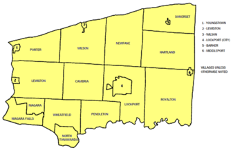
Cities, towns, villages, and other locations
- BarkerBarker, Niagara County, New YorkBarker is a village in Niagara County, New York, USA. The population was 577 at the 2000 census. The mail ZIP code is 14012. It is part of the Buffalo–Niagara Falls Metropolitan Statistical Area....
(village) - CambriaCambria, New YorkCambria is a town in Niagara County, New York, USA. The population was 5,839 at the 2010 census. Cambria is an early name for Wales.The Town of Cambria is in the center of Niagara County.New York State Route 93 passes through the town.- History :...
(town) - GasportGasport, New YorkGasport is a hamlet located in the Town of Royalton in Niagara County, New York, United States. The population was 1,248 at the 2000 census. The name is derived from observed natural gas and the historic Erie Canal port at that location...
(CDP) - HartlandHartland, New YorkHartland is a town in Niagara County, New York, USA.The population was 4,117 at the 2010 census.The town is named after Hartland, Vermont, the homeplace of some early settlers.The Town of Hartland is on the eastern border of the county.- History :...
(town) - LewistonLewiston, New YorkLewiston is a village in Niagara County, New York, United States. The population was 2,781 at the 2000 census. The village is named after Morgan Lewis, an early 19th-century governor of New York. It is part of the Buffalo–Niagara Falls Metropolitan Statistical Area.The Village of Lewiston,...
(village) - LewistonLewiston (town), New YorkLewiston is a town in Niagara County, New York United States. The population was 16,262 at the 2010 census. The town and its contained village are named after Morgan Lewis, a governor of New York....
(town) - LockportLockport (town), New YorkLockport is a town in Niagara County, New York, United States. The population was 20,529 at the 2010 census. The name is derived from the series of canal locks on the Erie Canal...
(town) - LockportLockport (city), New YorkLockport is a city in Niagara County, New York, United States. The population was 21,165 at the 2010 census. The name is derived from a set of Erie canal locks within the city. Lockport is the county seat of Niagara County and is surrounded by the town of Lockport...
(city) - MiddleportMiddleport, New YorkMiddleport is a village in Niagara County, New York, United States. The population was 1,917 at the 2000 census. The mail ZIP code is 14105. It is part of the Buffalo–Niagara Falls Metropolitan Statistical Area....
(village) - Newfane (town)
- NewfaneNewfane (CDP), New YorkNewfane is a census-designated place in the town of Newfane in Niagara County, New York, United States, along State Route 78. The population was 3,129 at the 2000 census...
(CDP) - Niagara FallsNiagara Falls, New YorkNiagara Falls is a city in Niagara County, New York, United States. As of the 2010 census, the city had a total population of 50,193, down from the 55,593 recorded in the 2000 census. It is across the Niagara River from Niagara Falls, Ontario , both named after the famed Niagara Falls which they...
(city) - NiagaraNiagara, New YorkNiagara is a town in Niagara County, New York, United States. As of the 2010 census, the town had a total population of 8,378. The town is named after the famous waterfall Niagara Falls....
(town) - North TonawandaNorth Tonawanda, New YorkNorth Tonawanda is a city in Niagara County, New York, United States. The population was 31,568 at the 2000 census. It is part of the Buffalo–Niagara Falls Metropolitan Statistical Area. The city is named after Tonawanda Creek, its south border...
(city) - OlcottOlcott, New YorkOlcott is a hamlet located in the Town of Newfane in Niagara County, New York, United States 14126. As of the 2000 census, this community population was 1,156. Most locals refer to it as Olcott Beach...
(CDP) - PendletonPendleton, New YorkPendleton is a town on the southern edge of Niagara County, New York, United States. It is east of the city of Niagara Falls and southwest of the city of Lockport. The population was 6,397 at the 2010 census.- History :...
(town) - PorterPorter, New YorkPorter is a town in Niagara County, New York, United States. The population was 6,771 at the 2010 census. The town was named after Judge Augustus Porter....
(town) - RansomvilleRansomville, New YorkRansomville is a hamlet located in the Town of Porter in Niagara County, New York, United States. The population was 1,488 at the 2000 census. Portions of the hamlet of Ransomville are also in Town of Wilson and Town of Cambria...
(CDP) - RapidsRapids, New YorkRapids is a hamlet located in the Town of Lockport in Niagara County, New York, United States. The population was 1,356 at the 2000 census....
(CDP) - RoyaltonRoyalton, New YorkRoyalton is a town in Niagara County, New York, United States. The population was 7,660 at the 2010 census.The Town of Royalton is in the southeast corner of the county and is east of the City of Niagara Falls.- History :...
(town) - SanbornSanborn, New YorkSanborn is a hamlet in the Towns of Cambria Wheatfield, New York and Lewiston, New York, USA, on the southeast corner of the intersection of New York State Route 429 and New York State Route 31. Originally called South Pekin after the formerly thriving hamlet of Pekin to the north, Sanborn was...
(hamlet) - SomersetSomerset, New YorkSomerset is a town in Niagara County, New York, United States. The population was 2,662 at the 2010 census. The town is believed to be named after Somerset, New Jersey, the source of some early settlers....
(town) - South LockportSouth Lockport, New YorkSouth Lockport is a hamlet located in the Town of Lockport in Niagara County, New York, United States. The population was 8,552 at the 2000 census...
- WheatfieldWheatfield, New YorkWheatfield is a town in Niagara County, New York, United States. The population was 18,117 at the 2010 census. The name stems from the agricultural use of the town lands: Growing Wheat....
(town) - WilsonWilson, New YorkWilson is a village in Niagara County, New York, United States. The population was 1,213 at the 2000 census. The village is said to be named after Luther Wilson. It is part of the Buffalo–Niagara Falls Metropolitan Statistical Area....
(village) - WilsonWilson (town), New YorkWilson is a town in Niagara County, New York, United States. The population was 5,993 at the 2010 census. The town is said to be named after an early settler....
(town) - YoungstownYoungstown, New YorkYoungstown is a village in Niagara County, New York, USA. The population was 1,957 at the 2000 census. It is part of the Buffalo–Niagara Falls Metropolitan Statistical Area....
(village)
- => designation in parentheses shows official political level.
Indian reservations
- Tuscarora ReservationTuscarora Reservation, New YorkThe Tuscarora Reservation is an Indian reservation in Niagara County, New York. The population was 1,152 at the 2010 census...
- Tonawanda Reservation
State parks and state lands
- De Veaux Woods State ParkDe Veaux Woods State ParkDe Veaux Woods State Park is a state park located in Niagara County, New York, USA.De Veaux Woods is located off the Robert Moses State Parkway, north of the City of Niagara Falls...
, north of the City of Niagara Falls. - Devil's Hole State ParkDevil's Hole State ParkDevil's Hole State Park is located in Niagara County, New York north of the City of Niagara Falls. The park overlooks the Niagara River Gorge.The park offers fishing, hiking, nature trail, picnic tables, snow-shoe trails, and cross-country skiing....
, immediately north of the City of Niagara Falls. - Fort Niagara State ParkFort Niagara State ParkFort Niagara State Park is located in the Town of Porter in Niagara County, New York, USA. Historic Fort Niagara is located within the park. The park is northwest of Youngstown, New York near the northern terminus of the Robert Moses State Parkway....
, located at the mouth of the Niagara River. - Earl W. Brydges Artpark State ParkEarl W. Brydges Artpark State ParkEarl W. Brydges Artpark State Park is located in the Village of Lewiston in Niagara County, New York, named after Earl Brydges. It is generally referred to as Artpark, and was created on the site of a former industrial waste dump...
, located in the Town of Lewiston. - Four Mile Creek State ParkFour Mile Creek State ParkFour Mile Creek State Park is located in the Town of Porter in Niagara County, New York. The park is at the mouth of Four Mile Creek on the shore of Lake Ontario....
, located on the shore of Lake Ontario. - Golden Hill State ParkGolden Hill State ParkGolden Hill State Park is located in the northeast corner of the Town of Somerset in Niagara County, New York, USA. The park is on the south shore of Lake Ontario, north of Lower Lake Road near Thirty Mile Point Light....
, located on the shore of Lake Ontario. - Hartland Swamp Wildlife Management AreaHartland Swamp Wildlife Management AreaThe Hartland Swamp Wildlife Management Area is a small conservation area located in western New York, USA. The Hartland Swamp WMA is located in northeastern Niagara County....
-- a conservation area in the Town of Hartland. - Joseph Davis State ParkJoseph Davis State ParkJoseph Davis State Park is located in the Town of Porter in Niagara County, New York. The park is near the Niagara River. This park has a free 27-hole disc golf course with restrooms and campground nearby. It has a finishing point of The Amazing Race: Family Edition when the Linz family had...
, along the Niagara River. - Niagara Reservation State Park, in the City of Niagara Falls.
- Reservoir State ParkReservoir State ParkReservoir State Park is a park located on the south shore of the Power Reservoir in the Town of Lewiston in Niagara County, New York, USA. Situated north of the City of Niagara Falls, the park is revered for its heavy flow of visitors....
, south of the power reservoir. - Tonawanda Wildlife Management AreaTonawanda Wildlife Management AreaThe Tonawanda Wildlife Management Area is a conservation area located in western New York, USA. Most of the area is in Niagara County and Genesee County, but a small portion is inside Orleans County....
, located partly in the Town of Royalton. - Wilson-Tuscarora State ParkWilson-Tuscarora State ParkWilson-Tuscarora State Park is a New York state park in Niagara County, New York, U.S. on the west side of the Village of Wilson. Lake Road passes through the park...
, located on the shore of Lake Ontario.
Educational institutions
Niagara UniversityNiagara University
Niagara University is a Catholic university in the Vincentian tradition, located in the Town of Lewiston in Niagara County, New York. Originally founded by the Congregation of the Mission in 1856 as Our Lady of Angels Seminary, it became Niagara University in 1883. The University is still run by...
is located in Lewiston, New York. Niagara County Community College
Niagara County Community College
Niagara County Community College is located in Sanborn, New York, USA northeast of the City of Niagara Falls. NCCC offers associate's degrees in many programs. Niagara County Community College was founded in 1962 and is sponsored by Niagara County and SUNY. The new campus opened in 1973...
is located in Sanborn
Sanborn, New York
Sanborn is a hamlet in the Towns of Cambria Wheatfield, New York and Lewiston, New York, USA, on the southeast corner of the intersection of New York State Route 429 and New York State Route 31. Originally called South Pekin after the formerly thriving hamlet of Pekin to the north, Sanborn was...
, New York
New York
New York is a state in the Northeastern region of the United States. It is the nation's third most populous state. New York is bordered by New Jersey and Pennsylvania to the south, and by Connecticut, Massachusetts and Vermont to the east...
. Many Niagara County residents also attend Erie
Erie County, New York
Erie County is a county located in the U.S. state of New York. As of the 2010 census, the population was 919,040. The county seat is Buffalo. The county's name comes from Lake Erie, which in turn comes from the Erie tribe of American Indians who lived south and east of the lake before 1654.Erie...
and other Western New York
Western New York
Western New York is the westernmost region of the state of New York. It includes the cities of Buffalo, Rochester, Niagara Falls, the surrounding suburbs, as well as the outlying rural areas of the Great Lakes lowlands, the Genesee Valley, and the Southern Tier. Some historians, scholars and others...
County Schools.
In the Buffalo
Buffalo, New York
Buffalo is the second most populous city in the state of New York, after New York City. Located in Western New York on the eastern shores of Lake Erie and at the head of the Niagara River across from Fort Erie, Ontario, Buffalo is the seat of Erie County and the principal city of the...
Metro area there more than 20 public and private colleges and universities in Buffalo and its environs offer programs in technical and vocational
Vocational education
Vocational education or vocational education and training is an education that prepares trainees for jobs that are based on manual or practical activities, traditionally non-academic, and totally related to a specific trade, occupation, or vocation...
training, graduate, and professional studies.
See also
- List of counties in New York
- National Register of Historic Places listings in Niagara County, New York