
New York State Route 250
Encyclopedia
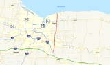
New York State Route 250 (NY 250) is a north–south state highway
in the eastern portion of Monroe County, New York
, in the United States. It extends for just over 16 miles (26 km) from an intersection with NY 96
in the town of Perinton
to a junction with Lake Road
(former NY 18
) near the Lake Ontario
shoreline in the town of Webster
. NY 250 passes through the villages of Fairport
and Webster
, where it meets NY 31F
and NY 104
, respectively. The highway is the easternmost north–south state route in Monroe County.
Most of the highway was taken over by the state of New York in the 1910s and 1920s. In 1908, the section of modern NY 250 in Fairport between Church and High Streets became part of Route 20, an unsigned legislative route
assigned by the New York State Legislature. The definition of the route was altered in 1921, taking the route on a more southerly course that used the portion of what is now NY 250 between NY 31
and NY 31F instead through eastern Monroe County. NY 250 was assigned to its current alignment as part of the 1930 renumbering of state highways in New York.
, begins at an intersection with NY 96
a short distance northwest of Eastview Mall
in the town of Perinton
. The two-lane route heads to the northeast as Moseley Road, a name it retains for the next 4 miles (6 km). It initially heads uphill through a forested area; however, at Garnsey Road, it turns northward and begins to slowly descend into a part of town dominated by housing tracts. The residential surroundings end 1 miles (1.6 km) north of Garnsey Road, where NY 250 meets NY 31
in a large commercial district that plays home to Perinton Square Mall, a shopping mall located just northeast of the junction. Past the junction, the route reenters a residential area and temporarily curves to the east to bypass a hill overlooking Ayrault Road. NY 250 returns to its due north routing at Ayrault Road and continues into the village of Fairport
, where it changes names from Moseley Road to South Main Street at Hulburt Road.
 In Fairport, NY 250 follows South Main Street down a large hill that levels off at the southern edge of the village's business district. Here, NY 250 intersects Church Street (NY 31F
) and passes by the First Baptist Church of Fairport
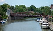
, located on the northwestern corner of the junction. The route continues north into the center of the village, passing by several small businesses and Fairport Village Landing—the largest shopping plaza in the village—before crossing over the Erie Canal
by way of a lift bridge and becoming North Main Street. Once on the north side of the canal, NY 250 crosses the CSX Transportation
-owned Rochester
and West Shore Subdivision
s at a single grade crossing ahead of High Street. At this point, the businesses give way to homes as the highway ascends a hill at the north end of the village and meets Whitney Road at the northern village line.
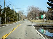
North of Whitney Road, NY 250 becomes Fairport – Nine Mile Point Road as it descends and ascends a series of small hills populated by homes on its way into Penfield
. About 0.5 mile (0.80467 km) north of the town line and 1.5 miles (2.4 km) north of Fairport, the route enters Lloyd's Corners, a commercial district surrounding NY 250's junction with NY 441
. The residential surroundings return north of the intersection, however, as the route approaches a junction with Whalen Road. Past this point, the homes begin to get further spaced apart as NY 250 heads northeastward into a rural area of eastern Monroe County. It remains on a northeastward course for just over 1 miles (1.6 km) before curving back to the north at a junction with NY 286
(Atlantic Avenue), its last major intersection before entering the town of Webster
as Webster Road.
 About 0.3 mile (0.482802 km) later, the highway reenters a more populated area that delimits the southern edge of the village of Webster
. Now South Avenue, NY 250 heads north through the densely populated southern half of the community, passing by Spry Middle School
on its way into the village center. Once again, the homes are supplanted by businesses as NY 250 and NY 404
(Main Street) meet at the heart of the business district. North of the junction, the route changes names to North Avenue and connects to the Irondequoit – Wayne County Expressway (NY 104
) at an interchange just two blocks from NY 404. It continues on, crossing the Ontario Midland Railroad
before leaving the village and becoming Webster Road once more. The highway heads onward through mostly residential areas of northeastern Webster to Lake Road
(formerly part of NY 18
), where NY 250 ends 250 yards (228.6 m) from the Lake Ontario
shoreline at Nine Mile Point.
during the 1910s and 1920s. Work to improve the highway to state highway standards was performed in stages, beginning in the town of Webster
and gradually heading south through Fairport
to Perinton
. The segment north of the Penfield
–Webster town line was improved at a cost of just over $103,807 (equivalent to $ in ) and added to the state highway system on October 24, 1913. Construction on the next section between Liftbridge Lane in Fairport
and the Penfield–Webster town line cost roughly $94,140 (equivalent to $ in ). It was accepted into the system on January 4, 1915.
South of Fairport, the section from modern NY 31
north to the Fairport village line was added on January 19, 1916, following a nearly $17,127 (equivalent to $ in ) project to improve the road. Lastly, the portion south of modern NY 31 was added in the late 1920s. The four state-maintained segments were legislatively designated, but not signed
, as State Highways 574, 574A, 1290, and 1836, respectively, for inventory purposes. The section of current NY 250 in Fairport between the southern village line and Liftbridge Lane was never taken over by the state and is village-maintained.
extending from Elbridge
to Rochester
via Fairport. Initially, Route 20 entered the village on High Street and followed Main Street south across the Erie Canal
to Church Street, where it turned west toward Rochester. On March 1, 1921, Route 20 was realigned to enter Monroe County
on modern NY 31. At the junction of Palmyra and Moseley Roads, Route 20 turned north, following SH 1290 into Fairport. It rejoined its original alignment at the junction of Church and Main Streets. None of SH 1290 received a signed designation when the first set of posted routes in New York were assigned in 1924.
SH 1290 was not assigned a signed designation until the 1930 renumbering of state highways in New York when it became part of NY 250, a new route that extended south over SH 1836 to NY 15 (now NY 96
) in Perinton and north over SH 574A and SH 574 to Lake Road
in Webster. When NY 33B—the predecessor to NY 31F
—was assigned ca. 1931, it entered Fairport on Church Street and turned north at NY 250, following the route across the Erie Canal to High Street, where NY 33B turned to the east. The overlap with NY 33B was replaced with a concurrency with NY 31F after the latter route largely replaced the former in the late 1940s. The overlap was eliminated on April 1, 1984, when NY 31F was rerouted out of the village along East Church Street and Turk Hill Road as the result of a highway maintenance swap between the state of New York and the village of Fairport.
State highway
State highway, state road or state route can refer to one of three related concepts, two of them related to a state or provincial government in a country that is divided into states or provinces :#A...
in the eastern portion of Monroe County, New York
Monroe County, New York
Monroe County is a county located in the U.S. state of New York. As of the 2010 census, the population was 744,344. It is named after James Monroe, fifth President of the United States of America. Its county seat is the city of Rochester....
, in the United States. It extends for just over 16 miles (26 km) from an intersection with NY 96
New York State Route 96
New York State Route 96 is a northwest–southeast state highway in the Finger Lakes region of New York in the United States. The southern terminus of the route is at an interchange with NY 17 in the Southern Tier village of Owego, Tioga County. Its northern terminus is at a junction with...
in the town of Perinton
Perinton, New York
Perinton is a town in Monroe County, New York, United States. The population was 46,090 at the 2000 census.The Village of Fairport, New York is within the town on the Erie Canal. Perinton is adjacent to the village of East Rochester , and the towns of Victor , Macedon , Pittsford , and Penfield...
to a junction with Lake Road
Lake Road (Western New York)
Lake Road is an east–west roadway in western New York, United States. It extends for from the Irondequoit Bay Outlet Bridge in the Monroe County town of Webster to NY 14 in the Wayne County village of Sodus Point. As its name implies, it follows the southern shore of Lake Ontario for its...
(former NY 18
New York State Route 18
New York State Route 18 is an east–west state highway in western New York in the United States. It runs parallel to the south shore of Lake Ontario for most of its length between Niagara County and Monroe County...
) near the Lake Ontario
Lake Ontario
Lake Ontario is one of the five Great Lakes of North America. It is bounded on the north and southwest by the Canadian province of Ontario, and on the south by the American state of New York. Ontario, Canada's most populous province, was named for the lake. In the Wyandot language, ontarío means...
shoreline in the town of Webster
Webster (town), New York
Webster is a town in the northeast corner of Monroe County, New York, United States. The town is named after orator and statesman Daniel Webster. The population was 42,641 at the 2010 census....
. NY 250 passes through the villages of Fairport
Fairport, New York
Fairport is a village located in the town of Perinton which is part of Monroe County, New York. Fairport is a suburb east of Rochester. It is also known as the "Crown Jewel of the Erie Canal"...
and Webster
Webster (village), New York
Webster is a village in Monroe County, New York, United States. The population was 5,216 at the 2000 census. The village and town are named after orator and statesman Daniel Webster....
, where it meets NY 31F
New York State Route 31F
New York State Route 31F is an east–west state highway located in the vicinity of Rochester, New York, in the United States. The western terminus of the route is at an intersection with NY 96 north of the Monroe County village of Pittsford. Its eastern terminus is at a junction...
and NY 104
New York State Route 104
New York State Route 104 is a long east–west state highway in Upstate New York, United States. It spans six counties and enters the vicinity of four cities—Niagara Falls, Lockport, Rochester, and Oswego—as it follows a routing largely parallel to that of the southern shoreline of Lake...
, respectively. The highway is the easternmost north–south state route in Monroe County.
Most of the highway was taken over by the state of New York in the 1910s and 1920s. In 1908, the section of modern NY 250 in Fairport between Church and High Streets became part of Route 20, an unsigned legislative route
Legislative route
In United States, a legislative route or legislative highway is a highway defined by laws passed in a state legislature. The numbering of such highways may or may not correspond to the numbers familiar to the public as part of the state, U.S. highway, and Interstate highway systems...
assigned by the New York State Legislature. The definition of the route was altered in 1921, taking the route on a more southerly course that used the portion of what is now NY 250 between NY 31
New York State Route 31
New York State Route 31 is a state highway that extends for across western and central New York in the United States. The western terminus of the route is at an intersection with NY 104 in the city of Niagara Falls. Its eastern terminus is at a traffic circle with NY 26 in Vernon...
and NY 31F instead through eastern Monroe County. NY 250 was assigned to its current alignment as part of the 1930 renumbering of state highways in New York.
Route description
NY 250, the easternmost north–south state route in Monroe CountyMonroe County, New York
Monroe County is a county located in the U.S. state of New York. As of the 2010 census, the population was 744,344. It is named after James Monroe, fifth President of the United States of America. Its county seat is the city of Rochester....
, begins at an intersection with NY 96
New York State Route 96
New York State Route 96 is a northwest–southeast state highway in the Finger Lakes region of New York in the United States. The southern terminus of the route is at an interchange with NY 17 in the Southern Tier village of Owego, Tioga County. Its northern terminus is at a junction with...
a short distance northwest of Eastview Mall
Eastview Mall
Eastview Mall, located in Victor, New York and managed by Mike Kauffman, is an indoor shopping center owned and operated by Wilmorite Management Group, LLC ....
in the town of Perinton
Perinton, New York
Perinton is a town in Monroe County, New York, United States. The population was 46,090 at the 2000 census.The Village of Fairport, New York is within the town on the Erie Canal. Perinton is adjacent to the village of East Rochester , and the towns of Victor , Macedon , Pittsford , and Penfield...
. The two-lane route heads to the northeast as Moseley Road, a name it retains for the next 4 miles (6 km). It initially heads uphill through a forested area; however, at Garnsey Road, it turns northward and begins to slowly descend into a part of town dominated by housing tracts. The residential surroundings end 1 miles (1.6 km) north of Garnsey Road, where NY 250 meets NY 31
New York State Route 31
New York State Route 31 is a state highway that extends for across western and central New York in the United States. The western terminus of the route is at an intersection with NY 104 in the city of Niagara Falls. Its eastern terminus is at a traffic circle with NY 26 in Vernon...
in a large commercial district that plays home to Perinton Square Mall, a shopping mall located just northeast of the junction. Past the junction, the route reenters a residential area and temporarily curves to the east to bypass a hill overlooking Ayrault Road. NY 250 returns to its due north routing at Ayrault Road and continues into the village of Fairport
Fairport, New York
Fairport is a village located in the town of Perinton which is part of Monroe County, New York. Fairport is a suburb east of Rochester. It is also known as the "Crown Jewel of the Erie Canal"...
, where it changes names from Moseley Road to South Main Street at Hulburt Road.
New York State Route 31F
New York State Route 31F is an east–west state highway located in the vicinity of Rochester, New York, in the United States. The western terminus of the route is at an intersection with NY 96 north of the Monroe County village of Pittsford. Its eastern terminus is at a junction...
) and passes by the First Baptist Church of Fairport
First Baptist Church of Fairport
The First Baptist Church of Fairport is a church, built in 1872, at 94 South Main Street at Church Street in Fairport, New York.In 2006 a national drugstore tried to buy the land but, in response to adverse local reactions, money was raised to help rebuild the church instead....
, located on the northwestern corner of the junction. The route continues north into the center of the village, passing by several small businesses and Fairport Village Landing—the largest shopping plaza in the village—before crossing over the Erie Canal
Erie Canal
The Erie Canal is a waterway in New York that runs about from Albany, New York, on the Hudson River to Buffalo, New York, at Lake Erie, completing a navigable water route from the Atlantic Ocean to the Great Lakes. The canal contains 36 locks and encompasses a total elevation differential of...
by way of a lift bridge and becoming North Main Street. Once on the north side of the canal, NY 250 crosses the CSX Transportation
CSX Transportation
CSX Transportation operates a Class I railroad in the United States known as the CSX Railroad. It is the main subsidiary of the CSX Corporation. The company is headquartered in Jacksonville, Florida, and owns approximately 21,000 route miles...
-owned Rochester
Rochester Subdivision
The Rochester Subdivision is a railroad line owned by CSX Transportation in the U.S. state of New York. The line runs from Syracuse west to Buffalo along the former New York Central Railroad main line. At its east end, west of downtown Syracuse, the line becomes the Mohawk Subdivision...
and West Shore Subdivision
West Shore Subdivision
The West Shore Subdivision is a railroad line owned by CSX Transportation in the U.S. state of New York. The line runs from Fairport, CP-359, west to North Chili, CP-382, along a former New York Central Railroad line. Both of its ends are at the Rochester Subdivision; it provides a southern bypass...
s at a single grade crossing ahead of High Street. At this point, the businesses give way to homes as the highway ascends a hill at the north end of the village and meets Whitney Road at the northern village line.
North of Whitney Road, NY 250 becomes Fairport – Nine Mile Point Road as it descends and ascends a series of small hills populated by homes on its way into Penfield
Penfield, New York
Penfield is a town in Monroe County, New York, United States. The population was 36,242 at the 2010 census.The town was incorporated in 1810 by the proprietor, Daniel Penfield, who purchased the town lands in 1795 and moved to the area in 1809. Penfield is a suburb of Rochester, New York...
. About 0.5 mile (0.80467 km) north of the town line and 1.5 miles (2.4 km) north of Fairport, the route enters Lloyd's Corners, a commercial district surrounding NY 250's junction with NY 441
New York State Route 441
New York State Route 441 is an east–west state highway in the eastern suburbs of Rochester, New York, United States. Its western terminus is at NY 96 in Brighton, and its eastern terminus is at NY 350 in Walworth. The portion of NY 441 in Brighton and western Penfield is a...
. The residential surroundings return north of the intersection, however, as the route approaches a junction with Whalen Road. Past this point, the homes begin to get further spaced apart as NY 250 heads northeastward into a rural area of eastern Monroe County. It remains on a northeastward course for just over 1 miles (1.6 km) before curving back to the north at a junction with NY 286
New York State Route 286
New York State Route 286 is an east–west state highway in the vicinity of the city of Rochester in New York, United States. It links Rochester to its eastern suburbs and to western Wayne County. The western terminus of the route is at exit 7 on NY 590 just inside the Rochester city...
(Atlantic Avenue), its last major intersection before entering the town of Webster
Webster (town), New York
Webster is a town in the northeast corner of Monroe County, New York, United States. The town is named after orator and statesman Daniel Webster. The population was 42,641 at the 2010 census....
as Webster Road.
Webster (village), New York
Webster is a village in Monroe County, New York, United States. The population was 5,216 at the 2000 census. The village and town are named after orator and statesman Daniel Webster....
. Now South Avenue, NY 250 heads north through the densely populated southern half of the community, passing by Spry Middle School
Spry Middle School
Spry Middle School is a middle school located in Webster, New York and is part of the Webster Central School District. It was built in 1924 as Webster High School. It was reopened in 1994 as a middle school....
on its way into the village center. Once again, the homes are supplanted by businesses as NY 250 and NY 404
New York State Route 404
New York State Route 404 is an east–west state highway located in eastern Monroe County, New York, in the United States. It extends for just over from an interchange with NY 590 in Irondequoit to an intersection with NY 104 on the Monroe–Wayne County line in the town of Webster...
(Main Street) meet at the heart of the business district. North of the junction, the route changes names to North Avenue and connects to the Irondequoit – Wayne County Expressway (NY 104
New York State Route 104
New York State Route 104 is a long east–west state highway in Upstate New York, United States. It spans six counties and enters the vicinity of four cities—Niagara Falls, Lockport, Rochester, and Oswego—as it follows a routing largely parallel to that of the southern shoreline of Lake...
) at an interchange just two blocks from NY 404. It continues on, crossing the Ontario Midland Railroad
Ontario Midland Railroad
The Ontario Midland Railroad is an American railroad company operating in western New York.It was founded on 5 October 1979 and was created to save the entire Rome, Watertown and Ogdensburg Railroad line from Oswego's West Yard to Suspension Bridge in Niagara Falls. However, the railroad managed...
before leaving the village and becoming Webster Road once more. The highway heads onward through mostly residential areas of northeastern Webster to Lake Road
Lake Road (Western New York)
Lake Road is an east–west roadway in western New York, United States. It extends for from the Irondequoit Bay Outlet Bridge in the Monroe County town of Webster to NY 14 in the Wayne County village of Sodus Point. As its name implies, it follows the southern shore of Lake Ontario for its...
(formerly part of NY 18
New York State Route 18
New York State Route 18 is an east–west state highway in western New York in the United States. It runs parallel to the south shore of Lake Ontario for most of its length between Niagara County and Monroe County...
), where NY 250 ends 250 yards (228.6 m) from the Lake Ontario
Lake Ontario
Lake Ontario is one of the five Great Lakes of North America. It is bounded on the north and southwest by the Canadian province of Ontario, and on the south by the American state of New York. Ontario, Canada's most populous province, was named for the lake. In the Wyandot language, ontarío means...
shoreline at Nine Mile Point.
State ownership
Most of what is now NY 250 was originally taken over by the state of New YorkNew York
New York is a state in the Northeastern region of the United States. It is the nation's third most populous state. New York is bordered by New Jersey and Pennsylvania to the south, and by Connecticut, Massachusetts and Vermont to the east...
during the 1910s and 1920s. Work to improve the highway to state highway standards was performed in stages, beginning in the town of Webster
Webster (town), New York
Webster is a town in the northeast corner of Monroe County, New York, United States. The town is named after orator and statesman Daniel Webster. The population was 42,641 at the 2010 census....
and gradually heading south through Fairport
Fairport, New York
Fairport is a village located in the town of Perinton which is part of Monroe County, New York. Fairport is a suburb east of Rochester. It is also known as the "Crown Jewel of the Erie Canal"...
to Perinton
Perinton, New York
Perinton is a town in Monroe County, New York, United States. The population was 46,090 at the 2000 census.The Village of Fairport, New York is within the town on the Erie Canal. Perinton is adjacent to the village of East Rochester , and the towns of Victor , Macedon , Pittsford , and Penfield...
. The segment north of the Penfield
Penfield, New York
Penfield is a town in Monroe County, New York, United States. The population was 36,242 at the 2010 census.The town was incorporated in 1810 by the proprietor, Daniel Penfield, who purchased the town lands in 1795 and moved to the area in 1809. Penfield is a suburb of Rochester, New York...
–Webster town line was improved at a cost of just over $103,807 (equivalent to $ in ) and added to the state highway system on October 24, 1913. Construction on the next section between Liftbridge Lane in Fairport
Fairport, New York
Fairport is a village located in the town of Perinton which is part of Monroe County, New York. Fairport is a suburb east of Rochester. It is also known as the "Crown Jewel of the Erie Canal"...
and the Penfield–Webster town line cost roughly $94,140 (equivalent to $ in ). It was accepted into the system on January 4, 1915.
South of Fairport, the section from modern NY 31
New York State Route 31
New York State Route 31 is a state highway that extends for across western and central New York in the United States. The western terminus of the route is at an intersection with NY 104 in the city of Niagara Falls. Its eastern terminus is at a traffic circle with NY 26 in Vernon...
north to the Fairport village line was added on January 19, 1916, following a nearly $17,127 (equivalent to $ in ) project to improve the road. Lastly, the portion south of modern NY 31 was added in the late 1920s. The four state-maintained segments were legislatively designated, but not signed
Unsigned highway
An unsigned highway is a highway that has been assigned a route number, but does not bear conventional road markings that would normally be used to identify the route with that number...
, as State Highways 574, 574A, 1290, and 1836, respectively, for inventory purposes. The section of current NY 250 in Fairport between the southern village line and Liftbridge Lane was never taken over by the state and is village-maintained.
Designation
In 1908, the New York State Legislature created Route 20, an unsigned legislative routeLegislative route
In United States, a legislative route or legislative highway is a highway defined by laws passed in a state legislature. The numbering of such highways may or may not correspond to the numbers familiar to the public as part of the state, U.S. highway, and Interstate highway systems...
extending from Elbridge
Elbridge (village), New York
The Village of Elbridge, is a village located in the western part of the Town of Elbridge and the western area of Onondaga County, New York, USA, about west of Syracuse. It is part of the Syracuse Metropolitan Statistical Area.- History :...
to Rochester
Rochester, New York
Rochester is a city in Monroe County, New York, south of Lake Ontario in the United States. Known as The World's Image Centre, it was also once known as The Flour City, and more recently as The Flower City...
via Fairport. Initially, Route 20 entered the village on High Street and followed Main Street south across the Erie Canal
Erie Canal
The Erie Canal is a waterway in New York that runs about from Albany, New York, on the Hudson River to Buffalo, New York, at Lake Erie, completing a navigable water route from the Atlantic Ocean to the Great Lakes. The canal contains 36 locks and encompasses a total elevation differential of...
to Church Street, where it turned west toward Rochester. On March 1, 1921, Route 20 was realigned to enter Monroe County
Monroe County, New York
Monroe County is a county located in the U.S. state of New York. As of the 2010 census, the population was 744,344. It is named after James Monroe, fifth President of the United States of America. Its county seat is the city of Rochester....
on modern NY 31. At the junction of Palmyra and Moseley Roads, Route 20 turned north, following SH 1290 into Fairport. It rejoined its original alignment at the junction of Church and Main Streets. None of SH 1290 received a signed designation when the first set of posted routes in New York were assigned in 1924.
SH 1290 was not assigned a signed designation until the 1930 renumbering of state highways in New York when it became part of NY 250, a new route that extended south over SH 1836 to NY 15 (now NY 96
New York State Route 96
New York State Route 96 is a northwest–southeast state highway in the Finger Lakes region of New York in the United States. The southern terminus of the route is at an interchange with NY 17 in the Southern Tier village of Owego, Tioga County. Its northern terminus is at a junction with...
) in Perinton and north over SH 574A and SH 574 to Lake Road
Lake Road (Western New York)
Lake Road is an east–west roadway in western New York, United States. It extends for from the Irondequoit Bay Outlet Bridge in the Monroe County town of Webster to NY 14 in the Wayne County village of Sodus Point. As its name implies, it follows the southern shore of Lake Ontario for its...
in Webster. When NY 33B—the predecessor to NY 31F
New York State Route 31F
New York State Route 31F is an east–west state highway located in the vicinity of Rochester, New York, in the United States. The western terminus of the route is at an intersection with NY 96 north of the Monroe County village of Pittsford. Its eastern terminus is at a junction...
—was assigned ca. 1931, it entered Fairport on Church Street and turned north at NY 250, following the route across the Erie Canal to High Street, where NY 33B turned to the east. The overlap with NY 33B was replaced with a concurrency with NY 31F after the latter route largely replaced the former in the late 1940s. The overlap was eliminated on April 1, 1984, when NY 31F was rerouted out of the village along East Church Street and Turk Hill Road as the result of a highway maintenance swap between the state of New York and the village of Fairport.