

New York State Route 590
Encyclopedia
New York State Route 590 (NY 590) is a 4.98 miles (8.01 km) north–south state highway
located in the eastern suburbs of Rochester, New York
, in the United States. The route is a limited-access northward extension of Interstate 590 (I-590) that begins at the Can of Worms, an interchange between I-490
, I-590, and NY 590 on the boundary between the town of Brighton
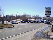
and the city of Rochester, and ends at a roundabout
with Titus Avenue in the town of Irondequoit
. NY 590 is known as the Sea Breeze Expressway, a name derived from the small community of Sea Breeze located near the highway's former northern terminus at Culver Road near the southern shore of Lake Ontario
.
The portion of NY 590 between the Can of Worms and NY 104
is part of the northeastern quadrant of the Rochester Outer Loop, a series of expressways that form a beltway around the city of Rochester. At NY 104, the Outer Loop turns west to follow NY 104 through Irondequoit. The Sea Breeze Expressway was built in stages from the 1950s to the 1960s and carried various designations until 1970, when the entirety of the Rochester – Sea Breeze highway was designated as part of NY 47
. It was redesignated as NY 590 in 1980. In the late 2000s, the section of NY 590 north of Titus Avenue was reconfigured into a two-lane road named Sea Breeze Drive, and NY 590 was truncated to end at Titus Avenue.
becomes NY 590 upon passing under I-490
at the Can of Worms on the eastern edge of Rochester
. It heads northeast into Brighton
and through the remainder of the interchange, passing under the ramp connecting I-490 west to I-590 south, the CSX Transportation
-owned Rochester Subdivision
, and the ramps from NY 590 south to I-490 in succession before widening to six lanes and turning northward ahead of a diamond interchange with Blossom Road, once designated as NY 286A. Between Blossom Road and NY 286
(Browncroft Boulevard), NY 590 slowly turns to the northwest, passing through densely populated neighborhoods located adjacent to the Rochester–Brighton boundary. It reaches the city line and reenters Rochester upon meeting NY 286.
The lone portion of NY 590 within the city of Rochester runs due north–south, acting as a divider between residential neighborhoods to the west and the Irondequoit Creek
valley (much of which is part of Ellison Park) to the east. Little more than a half mile after entering the city, NY 590 exits the city and enters the neighboring town of Irondequoit
. Here, the freeway turns to the northwest to avoid the area surrounding the intersection of North Winton Road and NY 404
(Empire Boulevard). After passing under North Winton Road, NY 590 resumes its northward trek and connects to NY 404 by way of a modified cloverleaf interchange
. The expressway continues onward, separating a large residential area from Irondequoit Bay Park West as it progresses toward a northbound-only exit with Norton Street. One half-mile to the north of Norton, NY 590 meets NY 104
via a large interchange.
Due to the terrain surrounding the interchange and the location of the Irondequoit Bay Bridge
, NY 104 is forced to run parallel to NY 590 for a short distance between the Keeler Street Expressway and NY 590's next exit, a diamond interchange connecting to East Ridge Road
. Through this stretch, NY 590—now just four lanes wide—runs in between NY 104 westbound and NY 104 eastbound. At East Ridge Road, NY 104 turns to the northeast to cross Irondequoit Bay
while NY 590 continues north through residential areas toward Sea Breeze. The road has an at-grade intersection with Sunrise Crescent, a private residential street, before meeting Titus Avenue at a roundabout
that serves as NY 590's northern terminus. Past this point, the right-of-way of NY 590 continues north to Culver Road at the Lake Ontario
shoreline as a divided two-lane street named Sea Breeze Drive.
Traveling southbound on NY 590, two significant movements are restricted due to the composition of the expressway. One is at Blossom Road in Brighton, where traffic entering NY 590 southbound cannot access I-490 due to the location of the exit 5 (left exit) flyover
, which begins north of the Blossom Road onramp. This movement was possible prior to the reconstruction of the Can of Worms, as the original connection point between the Sea Breeze Expressway and I-490 was south of the Blossom Road interchange. In Irondequoit, there are no southbound exits between East Ridge Road and NY 404; thus, there is no access to either NY 104 or Norton Street.
, part limited-access highway that extended from Rochester
north to the Lake Ontario
shoreline at Sea Breeze. The highway was built in stages from north to south, with the first section—a divided highway connecting Culver Road to East Ridge Road
in Irondequoit
—opening to traffic in the early 1950s as a realignment of NY 18
. The northern end of the roadway was situated just west of the Irondequoit Bay outlet, where Irondequoit Bay
meets Lake Ontario. Construction on the next segment, a limited-access extension south to Empire Boulevard (U.S. Route 104 or US 104), began in the mid-1950s. The new roadway was completed in the late 1950s, at which time it became part of a rerouted US 104.
 By 1960, construction was underway on the final piece, a second extension south to the Eastern Expressway (I-490
) in eastern Rochester. The under-construction highway generally paralleled Winton Road, then designated as part of NY 47
. The new extension was completed ca. 1961, but went unnumbered until ca. 1962 when NY 47 was realigned north of Blossom Road to follow the expressway north to the Empire Boulevard interchange, where it ended at US 104. The remainder of the Sea Breeze Expressway from I-490 to Blossom Road became part of NY 47 ca. 1965 following the completion of what is now I-590
from the Can of Worms to Elmwood Avenue.
From 1970 to 1980, the Sea Breeze Expressway underwent a series of designation changes. On January 1, 1970, NY 47 was extended northward to encompass the entirety of the Sea Breeze Expressway. The change resulted in overlaps with US 104 from Empire Boulevard to the new Keeler Street Expressway, which was built south of Ridge Road in the late 1960s as a realignment of US 104, and NY 18 from East Ridge Road to Culver Road, from where NY 18 continued east along Lake Road
to Webster
. Both overlaps proved to be temporary: US 104 was realigned ca. 1971 to cross Irondequoit Bay on the Irondequoit Bay Bridge
while NY 18 was truncated ca. 1973 to end in Rochester's Kodak Park
.
In the late 1970s, the state of New York submitted a proposal to the American Association of State Highway and Transportation Officials
that would substantially alter how the Outer Loop was numbered. As part of the plan, the NY 47 designation would be eliminated while most of the northeastern section of the Outer Loop—from I-490 in Rochester to NY 104
(former US 104) to Irondequoit—would become the northernmost part of I-590
. A replacement designation for NY 47 north of NY 104 was not named at the time. Most of the proposed changes took effect on March 18, 1980, when NY 47 was eliminated; however, I-590 was modified to end at its junction with I-490. In its place, the Rochester–Irondequoit leg of the Outer Loop was assigned NY 590, which continued north to Sea Breeze over former NY 47.
, the United States Representative representing Irondequoit, who later secured $8 million from the federal government for the project. Another $4.5 million of funding was also devoted to the project from the state of New York
. Planning for the project began in mid-2004. In late 2006, the Irondeqout Town Board chose a configuration calling for the number of lanes on NY 590 to be reduced to two and for four intersections to be replaced with roundabout
s as its "preferred alternative".
The final project design was presented on February 6, 2008, in the last of five public meetings on the project. Under the plan, the section of NY 590 north of Titus Avenue would be reduced to a two-lane, 25 mi/h parkway and named "Sea Breeze Drive". Its signalized intersections with Titus Avenue, Durand Boulevard, and Seneca and Point Pleasant Roads would be converted into roundabouts as part of the reconstruction. Also, the portion of NY 590 north of Durand Boulevard would be realigned to meet Culver Road at a new intersection farther west along the lakeshore. The realignment would open up 3 acres (1.2 ha) of waterfront land along the shore of Irondequoit Bay that had previously been occupied by the expressway. The town of Irondequoit would then acquire the former right-of-way of NY 590 from the state of New York for future recreational uses in a transaction that would officially cost the town $1.
Public opinion on the proposed project was split. Many residents supported the project, stating it would improve the safety of the highway; however, others believed that the reduction in lanes would result in increased traffic on Culver Road, which runs parallel to NY 590 through Irondequoit, and that the roundabouts would make navigating the highway difficult.
The first two of the roundabouts to reach operational status were those at Point Pleasant Road and Durand Boulevard. The Point Pleasant Road roundabout opened to traffic on September 8, 2009, by which time the Durand Boulevard roundabout was also ready for use. The Titus Avenue roundabout was completed in late 2009, while work on the Seneca Road junction was delayed until October 2009 due to the proximity of the intersection to the side of the hill overlooking Irondequoit Bay. Although the original plans for the project had already accounted for the issue, the plans had to be revised to comply with new federal standards regarding the use of steel pilings
for supporting the hillside. Work on the roundabout finally began on October 12. The Seneca Road roundabout and the new alignment of Sea Breeze Drive north of Durand Boulevard were completed in the first half of 2010.
The completion date for the project, dubbed "the largest public works project ever done in the town of Irondequoit" by then-Town Supervisor Mary Ellen Heyman, was pushed back several times. It was originally set for May 2010, but was subsequently pushed back to late August or early September. It was finally completed in October 2010 with the installation of a decorative ship mast structure at the Durand Boulevard roundabout. Following the project's completion, NY 590 was truncated to Titus Avenue and ownership and maintenance of Sea Breeze Drive was transferred to the town of Irondequoit. According to New York State Department of Transportation
(NYSDOT) official Rick Papaj, the state turned Sea Breeze Drive over to the town because the portion of NY 590 north of Titus Avenue had low traffic volumes and was situated in a residential area. Papaj added, "[the portion of NY 590 north of Titus Avenue] didn't make sense (to us) anymore. 590 effectively ends at Route 104."
|rowspan=2|Rochester
|rowspan=2|0.00
|
|
|Continuation beyond I-490
|-
|5
|
|Can of Worms
|-
|Brighton
|0.33
|6
|Blossom Road – Ellison Park
|Former western terminus of NY 286A
|-
|Rochester
|1.16
|7
|
|Western terminus of NY 286
|-
|rowspan=5|Irondequoit
|2.52
|8
|
|Western terminus of NY 404
|-
|3.33
|9
|Norton Street / Bayview Road
|Northbound exit and southbound entrance
|-
|4.02
|10
|
|Northbound exit and southbound entrance
|-
|4.48
|11
|East Ridge Road
|
|-
|4.98
|
|Titus Avenue (CR 91) / Sea Breeze Drive
|Roundabout
State highway
State highway, state road or state route can refer to one of three related concepts, two of them related to a state or provincial government in a country that is divided into states or provinces :#A...
located in the eastern suburbs of Rochester, New York
Rochester, New York
Rochester is a city in Monroe County, New York, south of Lake Ontario in the United States. Known as The World's Image Centre, it was also once known as The Flour City, and more recently as The Flower City...
, in the United States. The route is a limited-access northward extension of Interstate 590 (I-590) that begins at the Can of Worms, an interchange between I-490
Interstate 490 (New York)
Interstate 490 is an auxiliary Interstate Highway that serves the city of Rochester, New York, in the United States. It acts as a northerly alternate route to the New York State Thruway , leaving it at exit 47 in the town of Le Roy and rejoining the highway at exit 45 in the town of...
, I-590, and NY 590 on the boundary between the town of Brighton
Brighton, Monroe County, New York
Brighton is a town in Monroe County, New York, USA. The population was 36,609 at the 2010 census.-History:The Town of Brighton, located on the southeast border of the city of Rochester, was originally settled approximately 1790, and formally established in 1814—earning it recognition as one...
and the city of Rochester, and ends at a roundabout
Roundabout
A roundabout is the name for a road junction in which traffic moves in one direction around a central island. The word dates from the early 20th century. Roundabouts are common in many countries around the world...
with Titus Avenue in the town of Irondequoit
Irondequoit, New York
Irondequoit is a town in Monroe County, New York, USA. As of the 2010 census, the coterminous town-CDP had a total population of 51,692...
. NY 590 is known as the Sea Breeze Expressway, a name derived from the small community of Sea Breeze located near the highway's former northern terminus at Culver Road near the southern shore of Lake Ontario
Lake Ontario
Lake Ontario is one of the five Great Lakes of North America. It is bounded on the north and southwest by the Canadian province of Ontario, and on the south by the American state of New York. Ontario, Canada's most populous province, was named for the lake. In the Wyandot language, ontarío means...
.
The portion of NY 590 between the Can of Worms and NY 104
New York State Route 104
New York State Route 104 is a long east–west state highway in Upstate New York, United States. It spans six counties and enters the vicinity of four cities—Niagara Falls, Lockport, Rochester, and Oswego—as it follows a routing largely parallel to that of the southern shoreline of Lake...
is part of the northeastern quadrant of the Rochester Outer Loop, a series of expressways that form a beltway around the city of Rochester. At NY 104, the Outer Loop turns west to follow NY 104 through Irondequoit. The Sea Breeze Expressway was built in stages from the 1950s to the 1960s and carried various designations until 1970, when the entirety of the Rochester – Sea Breeze highway was designated as part of NY 47
New York State Route 47
New York State Route 47 was a long state highway around Rochester in New York, United States. It formed a semicircle through the inner suburbs of Rochester, following expressways west and east of the city and surface streets south of Rochester. The western terminus of the route was at an...
. It was redesignated as NY 590 in 1980. In the late 2000s, the section of NY 590 north of Titus Avenue was reconfigured into a two-lane road named Sea Breeze Drive, and NY 590 was truncated to end at Titus Avenue.
Route description
The four-lane I-590Interstate 590
Interstate 590 is a north–south auxiliary Interstate Highway that serves the immediate southeastern suburbs of the city of Rochester, New York, in the United States. It extends for from an interchange with I-390 in Brighton to the Can of Worms, a complex interchange connecting I-590 to I-490...
becomes NY 590 upon passing under I-490
Interstate 490 (New York)
Interstate 490 is an auxiliary Interstate Highway that serves the city of Rochester, New York, in the United States. It acts as a northerly alternate route to the New York State Thruway , leaving it at exit 47 in the town of Le Roy and rejoining the highway at exit 45 in the town of...
at the Can of Worms on the eastern edge of Rochester
Rochester, New York
Rochester is a city in Monroe County, New York, south of Lake Ontario in the United States. Known as The World's Image Centre, it was also once known as The Flour City, and more recently as The Flower City...
. It heads northeast into Brighton
Brighton, Monroe County, New York
Brighton is a town in Monroe County, New York, USA. The population was 36,609 at the 2010 census.-History:The Town of Brighton, located on the southeast border of the city of Rochester, was originally settled approximately 1790, and formally established in 1814—earning it recognition as one...
and through the remainder of the interchange, passing under the ramp connecting I-490 west to I-590 south, the CSX Transportation
CSX Transportation
CSX Transportation operates a Class I railroad in the United States known as the CSX Railroad. It is the main subsidiary of the CSX Corporation. The company is headquartered in Jacksonville, Florida, and owns approximately 21,000 route miles...
-owned Rochester Subdivision
Rochester Subdivision
The Rochester Subdivision is a railroad line owned by CSX Transportation in the U.S. state of New York. The line runs from Syracuse west to Buffalo along the former New York Central Railroad main line. At its east end, west of downtown Syracuse, the line becomes the Mohawk Subdivision...
, and the ramps from NY 590 south to I-490 in succession before widening to six lanes and turning northward ahead of a diamond interchange with Blossom Road, once designated as NY 286A. Between Blossom Road and NY 286
New York State Route 286
New York State Route 286 is an east–west state highway in the vicinity of the city of Rochester in New York, United States. It links Rochester to its eastern suburbs and to western Wayne County. The western terminus of the route is at exit 7 on NY 590 just inside the Rochester city...
(Browncroft Boulevard), NY 590 slowly turns to the northwest, passing through densely populated neighborhoods located adjacent to the Rochester–Brighton boundary. It reaches the city line and reenters Rochester upon meeting NY 286.
The lone portion of NY 590 within the city of Rochester runs due north–south, acting as a divider between residential neighborhoods to the west and the Irondequoit Creek
Irondequoit Creek
Irondequoit Creek is a stream in eastern Monroe County, New York that feeds Irondequoit Bay. It actually begins in rural West Bloomfield in Ontario County, flowing north into the town of Mendon in Monroe County...
valley (much of which is part of Ellison Park) to the east. Little more than a half mile after entering the city, NY 590 exits the city and enters the neighboring town of Irondequoit
Irondequoit, New York
Irondequoit is a town in Monroe County, New York, USA. As of the 2010 census, the coterminous town-CDP had a total population of 51,692...
. Here, the freeway turns to the northwest to avoid the area surrounding the intersection of North Winton Road and NY 404
New York State Route 404
New York State Route 404 is an east–west state highway located in eastern Monroe County, New York, in the United States. It extends for just over from an interchange with NY 590 in Irondequoit to an intersection with NY 104 on the Monroe–Wayne County line in the town of Webster...
(Empire Boulevard). After passing under North Winton Road, NY 590 resumes its northward trek and connects to NY 404 by way of a modified cloverleaf interchange
Cloverleaf interchange
A cloverleaf interchange is a two-level interchange in which left turns, reverse direction in left-driving regions, are handled by ramp roads...
. The expressway continues onward, separating a large residential area from Irondequoit Bay Park West as it progresses toward a northbound-only exit with Norton Street. One half-mile to the north of Norton, NY 590 meets NY 104
New York State Route 104
New York State Route 104 is a long east–west state highway in Upstate New York, United States. It spans six counties and enters the vicinity of four cities—Niagara Falls, Lockport, Rochester, and Oswego—as it follows a routing largely parallel to that of the southern shoreline of Lake...
via a large interchange.
Due to the terrain surrounding the interchange and the location of the Irondequoit Bay Bridge
Irondequoit Bay Bridge
Irondequoit Bay Bridge is located near Rochester, New York and carries Route 104 across the Irondequoit Bay between Irondequoit and Webster near the intersection with Rt 590. According to the National Bridge Inventory the bridge was built in 1967. Its total span is with nine spans and an...
, NY 104 is forced to run parallel to NY 590 for a short distance between the Keeler Street Expressway and NY 590's next exit, a diamond interchange connecting to East Ridge Road
Ridge Road (Western New York)
Ridge Road is a east–west road that traverses four counties in Upstate New York in the United States. It is named for the rise atop which the road was built, a mound of sand and gravel that was formed when it was the shoreline of ancient Glacial Lake Iroquois...
. Through this stretch, NY 590—now just four lanes wide—runs in between NY 104 westbound and NY 104 eastbound. At East Ridge Road, NY 104 turns to the northeast to cross Irondequoit Bay
Irondequoit Bay
Irondequoit Bay is a large body of water located in northeastern Monroe County, New York. The bay, roughly wide and in length, is fed by Irondequoit Creek to the south and flows into Lake Ontario at its northern end...
while NY 590 continues north through residential areas toward Sea Breeze. The road has an at-grade intersection with Sunrise Crescent, a private residential street, before meeting Titus Avenue at a roundabout
Roundabout
A roundabout is the name for a road junction in which traffic moves in one direction around a central island. The word dates from the early 20th century. Roundabouts are common in many countries around the world...
that serves as NY 590's northern terminus. Past this point, the right-of-way of NY 590 continues north to Culver Road at the Lake Ontario
Lake Ontario
Lake Ontario is one of the five Great Lakes of North America. It is bounded on the north and southwest by the Canadian province of Ontario, and on the south by the American state of New York. Ontario, Canada's most populous province, was named for the lake. In the Wyandot language, ontarío means...
shoreline as a divided two-lane street named Sea Breeze Drive.
Traveling southbound on NY 590, two significant movements are restricted due to the composition of the expressway. One is at Blossom Road in Brighton, where traffic entering NY 590 southbound cannot access I-490 due to the location of the exit 5 (left exit) flyover
Overpass
An overpass is a bridge, road, railway or similar structure that crosses over another road or railway...
, which begins north of the Blossom Road onramp. This movement was possible prior to the reconstruction of the Can of Worms, as the original connection point between the Sea Breeze Expressway and I-490 was south of the Blossom Road interchange. In Irondequoit, there are no southbound exits between East Ridge Road and NY 404; thus, there is no access to either NY 104 or Norton Street.
Construction and designation
The origins of NY 590 date back to the start of the 1950s when work first began on the Sea Breeze Expressway, a part-divided highwayDivided Highway
Divided Highway is a compilation album by American rock band The Doobie Brothers, released in 2003. . All tracks are taken from the albums Cycles and Brotherhood .-Track listing:...
, part limited-access highway that extended from Rochester
Rochester, New York
Rochester is a city in Monroe County, New York, south of Lake Ontario in the United States. Known as The World's Image Centre, it was also once known as The Flour City, and more recently as The Flower City...
north to the Lake Ontario
Lake Ontario
Lake Ontario is one of the five Great Lakes of North America. It is bounded on the north and southwest by the Canadian province of Ontario, and on the south by the American state of New York. Ontario, Canada's most populous province, was named for the lake. In the Wyandot language, ontarío means...
shoreline at Sea Breeze. The highway was built in stages from north to south, with the first section—a divided highway connecting Culver Road to East Ridge Road
Ridge Road (Western New York)
Ridge Road is a east–west road that traverses four counties in Upstate New York in the United States. It is named for the rise atop which the road was built, a mound of sand and gravel that was formed when it was the shoreline of ancient Glacial Lake Iroquois...
in Irondequoit
Irondequoit, New York
Irondequoit is a town in Monroe County, New York, USA. As of the 2010 census, the coterminous town-CDP had a total population of 51,692...
—opening to traffic in the early 1950s as a realignment of NY 18
New York State Route 18
New York State Route 18 is an east–west state highway in western New York in the United States. It runs parallel to the south shore of Lake Ontario for most of its length between Niagara County and Monroe County...
. The northern end of the roadway was situated just west of the Irondequoit Bay outlet, where Irondequoit Bay
Irondequoit Bay
Irondequoit Bay is a large body of water located in northeastern Monroe County, New York. The bay, roughly wide and in length, is fed by Irondequoit Creek to the south and flows into Lake Ontario at its northern end...
meets Lake Ontario. Construction on the next segment, a limited-access extension south to Empire Boulevard (U.S. Route 104 or US 104), began in the mid-1950s. The new roadway was completed in the late 1950s, at which time it became part of a rerouted US 104.
Interstate 490 (New York)
Interstate 490 is an auxiliary Interstate Highway that serves the city of Rochester, New York, in the United States. It acts as a northerly alternate route to the New York State Thruway , leaving it at exit 47 in the town of Le Roy and rejoining the highway at exit 45 in the town of...
) in eastern Rochester. The under-construction highway generally paralleled Winton Road, then designated as part of NY 47
New York State Route 47
New York State Route 47 was a long state highway around Rochester in New York, United States. It formed a semicircle through the inner suburbs of Rochester, following expressways west and east of the city and surface streets south of Rochester. The western terminus of the route was at an...
. The new extension was completed ca. 1961, but went unnumbered until ca. 1962 when NY 47 was realigned north of Blossom Road to follow the expressway north to the Empire Boulevard interchange, where it ended at US 104. The remainder of the Sea Breeze Expressway from I-490 to Blossom Road became part of NY 47 ca. 1965 following the completion of what is now I-590
Interstate 590
Interstate 590 is a north–south auxiliary Interstate Highway that serves the immediate southeastern suburbs of the city of Rochester, New York, in the United States. It extends for from an interchange with I-390 in Brighton to the Can of Worms, a complex interchange connecting I-590 to I-490...
from the Can of Worms to Elmwood Avenue.
From 1970 to 1980, the Sea Breeze Expressway underwent a series of designation changes. On January 1, 1970, NY 47 was extended northward to encompass the entirety of the Sea Breeze Expressway. The change resulted in overlaps with US 104 from Empire Boulevard to the new Keeler Street Expressway, which was built south of Ridge Road in the late 1960s as a realignment of US 104, and NY 18 from East Ridge Road to Culver Road, from where NY 18 continued east along Lake Road
Lake Road (Western New York)
Lake Road is an east–west roadway in western New York, United States. It extends for from the Irondequoit Bay Outlet Bridge in the Monroe County town of Webster to NY 14 in the Wayne County village of Sodus Point. As its name implies, it follows the southern shore of Lake Ontario for its...
to Webster
Webster (town), New York
Webster is a town in the northeast corner of Monroe County, New York, United States. The town is named after orator and statesman Daniel Webster. The population was 42,641 at the 2010 census....
. Both overlaps proved to be temporary: US 104 was realigned ca. 1971 to cross Irondequoit Bay on the Irondequoit Bay Bridge
Irondequoit Bay Bridge
Irondequoit Bay Bridge is located near Rochester, New York and carries Route 104 across the Irondequoit Bay between Irondequoit and Webster near the intersection with Rt 590. According to the National Bridge Inventory the bridge was built in 1967. Its total span is with nine spans and an...
while NY 18 was truncated ca. 1973 to end in Rochester's Kodak Park
Kodak Park
Eastman Business Park, formerly Kodak Park, is a large manufacturing and industrial complex in the city of Rochester, New York, in the United States. The complex is run by Eastman Kodak and is located north of downtown Rochester and south of Lake Ontario...
.
In the late 1970s, the state of New York submitted a proposal to the American Association of State Highway and Transportation Officials
American Association of State Highway and Transportation Officials
AASHTO, the American Association of State Highway and Transportation Officials, is a standards setting body which publishes specifications, test protocols and guidelines which are used in highway design and construction throughout the United States...
that would substantially alter how the Outer Loop was numbered. As part of the plan, the NY 47 designation would be eliminated while most of the northeastern section of the Outer Loop—from I-490 in Rochester to NY 104
New York State Route 104
New York State Route 104 is a long east–west state highway in Upstate New York, United States. It spans six counties and enters the vicinity of four cities—Niagara Falls, Lockport, Rochester, and Oswego—as it follows a routing largely parallel to that of the southern shoreline of Lake...
(former US 104) to Irondequoit—would become the northernmost part of I-590
Interstate 590
Interstate 590 is a north–south auxiliary Interstate Highway that serves the immediate southeastern suburbs of the city of Rochester, New York, in the United States. It extends for from an interchange with I-390 in Brighton to the Can of Worms, a complex interchange connecting I-590 to I-490...
. A replacement designation for NY 47 north of NY 104 was not named at the time. Most of the proposed changes took effect on March 18, 1980, when NY 47 was eliminated; however, I-590 was modified to end at its junction with I-490. In its place, the Rochester–Irondequoit leg of the Outer Loop was assigned NY 590, which continued north to Sea Breeze over former NY 47.
Project origins
In 1995, Irondequoit Town Supervisor David Schantz proposed the idea of converting the portion of NY 590 north of Titus Avenue into a parkway that would serve as a "gateway" into Irondequoit. He presented the idea to Jim WalshJames T. Walsh
James Thomas "Jim" Walsh is an American Republican politician from Syracuse, New York. In 2009, he retired after representing a portion of Central New York, that is now known as the state's 25th Congressional District, in the United States House of Representatives for twenty years.-Early...
, the United States Representative representing Irondequoit, who later secured $8 million from the federal government for the project. Another $4.5 million of funding was also devoted to the project from the state of New York
New York
New York is a state in the Northeastern region of the United States. It is the nation's third most populous state. New York is bordered by New Jersey and Pennsylvania to the south, and by Connecticut, Massachusetts and Vermont to the east...
. Planning for the project began in mid-2004. In late 2006, the Irondeqout Town Board chose a configuration calling for the number of lanes on NY 590 to be reduced to two and for four intersections to be replaced with roundabout
Roundabout
A roundabout is the name for a road junction in which traffic moves in one direction around a central island. The word dates from the early 20th century. Roundabouts are common in many countries around the world...
s as its "preferred alternative".
The final project design was presented on February 6, 2008, in the last of five public meetings on the project. Under the plan, the section of NY 590 north of Titus Avenue would be reduced to a two-lane, 25 mi/h parkway and named "Sea Breeze Drive". Its signalized intersections with Titus Avenue, Durand Boulevard, and Seneca and Point Pleasant Roads would be converted into roundabouts as part of the reconstruction. Also, the portion of NY 590 north of Durand Boulevard would be realigned to meet Culver Road at a new intersection farther west along the lakeshore. The realignment would open up 3 acres (1.2 ha) of waterfront land along the shore of Irondequoit Bay that had previously been occupied by the expressway. The town of Irondequoit would then acquire the former right-of-way of NY 590 from the state of New York for future recreational uses in a transaction that would officially cost the town $1.
Public opinion on the proposed project was split. Many residents supported the project, stating it would improve the safety of the highway; however, others believed that the reduction in lanes would result in increased traffic on Culver Road, which runs parallel to NY 590 through Irondequoit, and that the roundabouts would make navigating the highway difficult.
Construction
On July 15, 2008, the town of Irondequoit let a $12.8 million contract for the Sea Breeze Drive project, a mark that was within the $14 million accumulated in funding by this time. Ground was officially broken on the project on July 28 as part of a ceremony attended by several Rochester-area dignitaries. Among those present were Jim Walsh and David Schantz, both of whom played large roles in making the project a reality. The corridor was subsequently reduced to two lanes as the southbound lanes of NY 590 were reconfigured to handle both directions of traffic while work ensued on permanently narrowing the northbound lanes to a single lane. Northbound traffic on NY 590 was realigned to use the new northbound lane on August 17, 2009.The first two of the roundabouts to reach operational status were those at Point Pleasant Road and Durand Boulevard. The Point Pleasant Road roundabout opened to traffic on September 8, 2009, by which time the Durand Boulevard roundabout was also ready for use. The Titus Avenue roundabout was completed in late 2009, while work on the Seneca Road junction was delayed until October 2009 due to the proximity of the intersection to the side of the hill overlooking Irondequoit Bay. Although the original plans for the project had already accounted for the issue, the plans had to be revised to comply with new federal standards regarding the use of steel pilings
Deep foundation
A deep foundation is a type of foundation distinguished from shallow foundations by the depth they are embedded into the ground. There are many reasons a geotechnical engineer would recommend a deep foundation over a shallow foundation, but some of the common reasons are very large design loads, a...
for supporting the hillside. Work on the roundabout finally began on October 12. The Seneca Road roundabout and the new alignment of Sea Breeze Drive north of Durand Boulevard were completed in the first half of 2010.
The completion date for the project, dubbed "the largest public works project ever done in the town of Irondequoit" by then-Town Supervisor Mary Ellen Heyman, was pushed back several times. It was originally set for May 2010, but was subsequently pushed back to late August or early September. It was finally completed in October 2010 with the installation of a decorative ship mast structure at the Durand Boulevard roundabout. Following the project's completion, NY 590 was truncated to Titus Avenue and ownership and maintenance of Sea Breeze Drive was transferred to the town of Irondequoit. According to New York State Department of Transportation
New York State Department of Transportation
The New York State Department of Transportation is responsible for the development and operation of highways, railroads, mass transit systems, ports, waterways and aviation facilities in the U.S...
(NYSDOT) official Rick Papaj, the state turned Sea Breeze Drive over to the town because the portion of NY 590 north of Titus Avenue had low traffic volumes and was situated in a residential area. Papaj added, "[the portion of NY 590 north of Titus Avenue] didn't make sense (to us) anymore. 590 effectively ends at Route 104."
Exit list
|-|rowspan=2|Rochester
Rochester, New York
Rochester is a city in Monroe County, New York, south of Lake Ontario in the United States. Known as The World's Image Centre, it was also once known as The Flour City, and more recently as The Flower City...
|rowspan=2|0.00
|
|
|Continuation beyond I-490
|-
|5
|
|Can of Worms
|-
|Brighton
Brighton, Monroe County, New York
Brighton is a town in Monroe County, New York, USA. The population was 36,609 at the 2010 census.-History:The Town of Brighton, located on the southeast border of the city of Rochester, was originally settled approximately 1790, and formally established in 1814—earning it recognition as one...
|0.33
|6
|Blossom Road – Ellison Park
|Former western terminus of NY 286A
|-
|Rochester
Rochester, New York
Rochester is a city in Monroe County, New York, south of Lake Ontario in the United States. Known as The World's Image Centre, it was also once known as The Flour City, and more recently as The Flower City...
|1.16
|7
|
|Western terminus of NY 286
|-
|rowspan=5|Irondequoit
Irondequoit, New York
Irondequoit is a town in Monroe County, New York, USA. As of the 2010 census, the coterminous town-CDP had a total population of 51,692...
|2.52
|8
|
|Western terminus of NY 404
|-
|3.33
|9
|Norton Street / Bayview Road
|Northbound exit and southbound entrance
|-
|4.02
|10
|
|Northbound exit and southbound entrance
|-
|4.48
|11
|East Ridge Road
Ridge Road (Western New York)
Ridge Road is a east–west road that traverses four counties in Upstate New York in the United States. It is named for the rise atop which the road was built, a mound of sand and gravel that was formed when it was the shoreline of ancient Glacial Lake Iroquois...
|
|-
|4.98
|
|Titus Avenue (CR 91) / Sea Breeze Drive
|Roundabout
Roundabout
A roundabout is the name for a road junction in which traffic moves in one direction around a central island. The word dates from the early 20th century. Roundabouts are common in many countries around the world...