

New York State Route 69
Encyclopedia
New York State Route 69 (NY 69) is a state highway
extending for 57.42 miles (92.41 km) across the central portion
of the U.S. state
of New York
. The western terminus of the route is at NY 104
in the Oswego County
village of Mexico
. The eastern terminus is at NY 5A
in the Oneida County
village of Yorkville
, just west of Utica
. In between, NY 69 serves the city of Rome
.
When NY 69 was first assigned in 1930, it stretched only from Colosse to Rome
. By the early 1940s, NY 69 was extended to encompass all of its current alignment, as well as what is now NY 5A
from Yorkville to Utica. It was reduced to its current length in 1970.
. The route heads southward, intersecting with local roads. The highgway enters a region of rural farmland as it progresses to the southeast. After a while, Route 69 enters Colosse, a hamlet of Parish
. There, it intersects with U.S. Route 11, which heads northward towards the Canadian
border. Route 69 enters the village of Parish, where it intersects with its lone suffixed route, Route 69A. There it also intersects with several county-maintained roads.
In the village of Parish
, Route 69 meets Interstate 81
at exit 33. Afterwards, the highway leaves the village and re-enters the town, crossing through more farmlands and lakes. Route 69 intersects with more county roads as it heads eastward towards Amboy Center. Route 69 begins curving to the southeast and enters the Amboy
hamlet of Amboy Center, where it intersects with NY 183
. Also present in Amboy Center are two county roads. Route 69 continues southeast, this time towards Camden
, which is in Oneida County
. Route 69 enters Camden, where it becomes concurrent with NY 13
in the center of the village.
 Routes 69 and 13 split, and 69 continues out of downtown Camden. Route 69 enters Annsville and Taberg, where it intersects with a couple of county roads. Route 69 continues to the southeast towards Rome
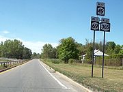
as Rome-Taberg Road. The highway quickly enters Rome and becomes concurrent with Routes 49
and 46
on the southwestern section of the city. The three routes pass to the south of Liberty Gardens, an attraction in Rome. The three routes head southward, intersecting with NY 26
, and Route 46 turns off. Routes 49 and 69 head southward and become concurrent with Route 365
. Route 69 turns off after a short distance along NY 365 and continues to the southeast as Rome-Oriskany Road.
Route 49 parallels the southeastern moving route to the north away from the city of Rome. Route 69 enters Oriskany
, where it intersects with NY 291
. The highway heads southward, entering Whitesboro
, passing its local fire department memorial park and crossing the New York State Thruway
. Route 69 terminates at an interchange with NY 5A
in Yorkville
.
, by the New York State Legislature in 1908. Route 28 began in Utica
and followed modern NY 5A
and NY 69 to Whitesboro
, where it crossed the Mohawk River
on current NY 291
and headed west to Rome
on River Road (former NY 49
). Route 28 rejoined modern NY 69 west of Rome and followed it through Camden
to Colosse. Here, Route 28 turned north onto what is now U.S. Route 11 to meet Route 30 (now NY 104
) in Maple View. When the first set of posted routes in New York
were assigned in 1924, all of legislative Route 28 was designated as part of NY 11, an east–west highway extending from Oswego
to Utica. From Oswego to Colosse, NY 11 overlapped with NY 2 and NY 3
(now US 11 and NY 104, respectively). The route was truncated to NY 2 in Colosse on its western end by 1926.
In 1927, the entirety of NY 2 was redesignated as part of the new U.S. Route 11. To eliminate duplication, all of NY 11 was renumbered to NY 76. This route remained intact up to the 1930 renumbering of state highways in New York when NY 76 was split into several routes. East of Rome, the former routing of NY 76 became an eastward extension of NY 49 from Rome to Marcy
. Between Marcy and Utica, old NY 76 was incorporated into the new NY 12C. West of Rome, old NY 76 was renumbered to NY 69. At the time, modern NY 69 from Mexico
to Colosse was unnumbered while the portion of current NY 69 between Rome and Utica was part of NY 5S
, an alternate route of NY 5
assigned as part of the renumbering. From Whitesboro to Utica, NY 5S and NY 12C were concurrent.
Ca. 1940, NY 69 was extended a short distance westward to its present western terminus at then-U.S. Route 104 (now NY 104
) in Mexico
. It was extended eastward in the early 1940s when NY 5S was truncated to its present western terminus in downtown Utica. The former routing of NY 5S from Rome to Genesee Street in downtown Utica became part of NY 69. East of Whitesboro
, NY 69 overlapped NY 12C; east of Yorkville, NY 69 also overlapped NY 5A
. The overlaps between NY 5A, NY 12C, and NY 69 in Utica were eliminated on January 1, 1970, when NY 69 was truncated to its current eastern terminus in Yorkville and the NY 12C designation was eliminated.
 NY 69A (2.04 miles or 3.28 km) is a short two-lane spur connecting NY 69 to the hamlet of Hastings
in Oswego County
. The route begins at US 11
in Hastings and heads northeast to Parish
, where it ends at NY 69. It was assigned ca. 1931.
State highway
State highway, state road or state route can refer to one of three related concepts, two of them related to a state or provincial government in a country that is divided into states or provinces :#A...
extending for 57.42 miles (92.41 km) across the central portion
Central New York
Central New York is a term used to broadly describe the central region of New York State, roughly including the following counties and cities:...
of the U.S. state
U.S. state
A U.S. state is any one of the 50 federated states of the United States of America that share sovereignty with the federal government. Because of this shared sovereignty, an American is a citizen both of the federal entity and of his or her state of domicile. Four states use the official title of...
of New York
New York
New York is a state in the Northeastern region of the United States. It is the nation's third most populous state. New York is bordered by New Jersey and Pennsylvania to the south, and by Connecticut, Massachusetts and Vermont to the east...
. The western terminus of the route is at NY 104
New York State Route 104
New York State Route 104 is a long east–west state highway in Upstate New York, United States. It spans six counties and enters the vicinity of four cities—Niagara Falls, Lockport, Rochester, and Oswego—as it follows a routing largely parallel to that of the southern shoreline of Lake...
in the Oswego County
Oswego County, New York
Oswego County is a county located in the U.S. state of New York. As of the 2010 Census, the estimated population was 122,109. The City of Oswego and the Village of Pulaski serve as the dual county seats in a two shire system of government...
village of Mexico
Mexico (village), New York
Mexico is a village in Oswego County, New York, USA. The population was 1,572 at the 2000 census.The Village of Mexico is located in the Town of Mexico at New York State Routes 3, 69, and 104.Mexico is called "Mother of Towns"...
. The eastern terminus is at NY 5A
New York State Route 5A
New York State Route 5A is an east–west state highway contained within Oneida County, New York, in the United States. It is a alternate route of NY 5 between New Hartford and downtown Utica. At its eastern end, NY 5A becomes NY 5S. The route is four lanes wide and passes...
in the Oneida County
Oneida County, New York
Oneida County is a county located in the U.S. state of New York. As of the 2010 census, the population was 234,878. The county seat is Utica. The name is in honor of the Oneida, an Iroquoian tribe that formerly occupied the region....
village of Yorkville
Yorkville, Oneida County, New York
Yorkville is a village in Oneida County, New York, USA. The population was 2,675 at the 2000 census.The Village of Yorkville is in the southeast part of the Town of Whitestown adjacent to the City of Utica.- History :...
, just west of Utica
Utica, New York
Utica is a city in and the county seat of Oneida County, New York, United States. The population was 62,235 at the 2010 census, an increase of 2.6% from the 2000 census....
. In between, NY 69 serves the city of Rome
Rome, New York
Rome is a city in Oneida County, New York, United States. It is located in north-central or "upstate" New York. The population was 44,797 at the 2010 census. It is in New York's 24th congressional district. In 1758, British forces began construction of Fort Stanwix at this strategic location, but...
.
When NY 69 was first assigned in 1930, it stretched only from Colosse to Rome
Rome, New York
Rome is a city in Oneida County, New York, United States. It is located in north-central or "upstate" New York. The population was 44,797 at the 2010 census. It is in New York's 24th congressional district. In 1758, British forces began construction of Fort Stanwix at this strategic location, but...
. By the early 1940s, NY 69 was extended to encompass all of its current alignment, as well as what is now NY 5A
New York State Route 5A
New York State Route 5A is an east–west state highway contained within Oneida County, New York, in the United States. It is a alternate route of NY 5 between New Hartford and downtown Utica. At its eastern end, NY 5A becomes NY 5S. The route is four lanes wide and passes...
from Yorkville to Utica. It was reduced to its current length in 1970.
Route description
Route 69 begins at an intersection with Route 104 in the village of MexicoMexico (village), New York
Mexico is a village in Oswego County, New York, USA. The population was 1,572 at the 2000 census.The Village of Mexico is located in the Town of Mexico at New York State Routes 3, 69, and 104.Mexico is called "Mother of Towns"...
. The route heads southward, intersecting with local roads. The highgway enters a region of rural farmland as it progresses to the southeast. After a while, Route 69 enters Colosse, a hamlet of Parish
Parish (town), New York
Parish is a town in Oswego County, New York, United States. The population was 2,694 at the 2000 census.The Town of Parish was created from the Town of Mexico in 1828...
. There, it intersects with U.S. Route 11, which heads northward towards the Canadian
Canada
Canada is a North American country consisting of ten provinces and three territories. Located in the northern part of the continent, it extends from the Atlantic Ocean in the east to the Pacific Ocean in the west, and northward into the Arctic Ocean...
border. Route 69 enters the village of Parish, where it intersects with its lone suffixed route, Route 69A. There it also intersects with several county-maintained roads.
In the village of Parish
Parish (village), New York
Parish is a village in Oswego County, New York, United States. The population was 512 as of the census of 2000.-Geography:Parish is located at ....
, Route 69 meets Interstate 81
Interstate 81 in New York
Interstate 81 is a part of the Interstate Highway System that runs from Dandridge, Tennessee, to the Canada – United States border at Wellesley Island in New York. In the U.S. state of New York, I-81 extends from the Pennsylvania state line southeast of Binghamton to the Canadian border...
at exit 33. Afterwards, the highway leaves the village and re-enters the town, crossing through more farmlands and lakes. Route 69 intersects with more county roads as it heads eastward towards Amboy Center. Route 69 begins curving to the southeast and enters the Amboy
Amboy, New York
Amboy is a town in Oswego County, New York, United States. The population was 1,312 at the 2000 census. The town is named after a location in New Jersey.The Town of Amboy is in the southeastern part of the county.- History :...
hamlet of Amboy Center, where it intersects with NY 183
New York State Route 183
New York State Route 183 is a state highway located within Oswego County, New York, United States. The southern terminus is at an intersection with NY 69 in the hamlet of Amboy Center within the town of Amboy...
. Also present in Amboy Center are two county roads. Route 69 continues southeast, this time towards Camden
Camden (village), New York
Camden is a village in Oneida County, New York, USA. The population was 2,330 at the 2000 census.The Village of Camden is located inside the Town of Camden at the crossing of Routes NY-13 and NY-69.-History:The W.H...
, which is in Oneida County
Oneida County, New York
Oneida County is a county located in the U.S. state of New York. As of the 2010 census, the population was 234,878. The county seat is Utica. The name is in honor of the Oneida, an Iroquoian tribe that formerly occupied the region....
. Route 69 enters Camden, where it becomes concurrent with NY 13
New York State Route 13
New York State Route 13 is a state highway that runs mainly north–south for between NY 14 in Horseheads and NY 3 west of Pulaski in Central New York in the United States. In between, NY 13 intersects with Interstate 81 in Cortland and Pulaski and meets the New York...
in the center of the village.
Rome, New York
Rome is a city in Oneida County, New York, United States. It is located in north-central or "upstate" New York. The population was 44,797 at the 2010 census. It is in New York's 24th congressional district. In 1758, British forces began construction of Fort Stanwix at this strategic location, but...
as Rome-Taberg Road. The highway quickly enters Rome and becomes concurrent with Routes 49
New York State Route 49
New York State Route 49 is an east–west state highway in New York in the United States. It runs from NY 3 in Volney to Interstate 790 , NY 5, NY 8 and NY 12 in Utica...
and 46
New York State Route 46
New York State Route 46 is a state highway in Central New York, United States. It extends from NY 12B in the Madison County town of Eaton to NY 12D in the Oneida County village of Boonville. NY 46 passes through the cities of Oneida and Rome.-Madison County:NY 46 begins at...
on the southwestern section of the city. The three routes pass to the south of Liberty Gardens, an attraction in Rome. The three routes head southward, intersecting with NY 26
New York State Route 26
New York State Route 26 is a north–south state highway that runs for through Central New York in the United States. Its southern terminus is located at the Pennsylvania state line south of the town of Vestal in Broome County, where it becomes Pennsylvania Route 267...
, and Route 46 turns off. Routes 49 and 69 head southward and become concurrent with Route 365
New York State Route 365
New York State Route 365 is an east–west state highway in the central portion of New York in the United States. It extends for from an intersection with NY 5 east of the Oneida County city of Oneida to a junction with NY 8 in the Herkimer County town of Ohio...
. Route 69 turns off after a short distance along NY 365 and continues to the southeast as Rome-Oriskany Road.
Route 49 parallels the southeastern moving route to the north away from the city of Rome. Route 69 enters Oriskany
Oriskany, New York
Oriskany is a village in Oneida County, New York, United States. The population was 2,744 at the 2000 census. The name is derived from the Iroquois word for "nettles."The Village of Oriskany is in the Town of Whitestown, southeast of the City of Rome...
, where it intersects with NY 291
New York State Route 291
New York State Route 291 is a state highway in Oneida County, New York, in the United States. The route extends from an intersection with NY 69 in the town of Whitestown to a junction with NY 365 in the extreme northern tip of the town of Marcy, near the hamlet of Stittville. It is...
. The highway heads southward, entering Whitesboro
Whitesboro, New York
Whitesboro is a village in Oneida County, New York, United States. United States. The population was 3,943 at the 2000 census. The village is named after Hugh White, an early settler.The Village of Whitesboro is inside the Town of Whitestown....
, passing its local fire department memorial park and crossing the New York State Thruway
New York State Thruway
The New York State Thruway is a system of limited-access highways located within the state of New York in the United States. The system, known officially as the Governor Thomas E. Dewey Thruway for former New York Governor Thomas E. Dewey, is operated by the New York State Thruway Authority and...
. Route 69 terminates at an interchange with NY 5A
New York State Route 5A
New York State Route 5A is an east–west state highway contained within Oneida County, New York, in the United States. It is a alternate route of NY 5 between New Hartford and downtown Utica. At its eastern end, NY 5A becomes NY 5S. The route is four lanes wide and passes...
in Yorkville
Yorkville, Oneida County, New York
Yorkville is a village in Oneida County, New York, USA. The population was 2,675 at the 2000 census.The Village of Yorkville is in the southeast part of the Town of Whitestown adjacent to the City of Utica.- History :...
.
History
Most of what is now NY 69 was originally designated as part of Route 28, an unsigned legislative routeLegislative route
In United States, a legislative route or legislative highway is a highway defined by laws passed in a state legislature. The numbering of such highways may or may not correspond to the numbers familiar to the public as part of the state, U.S. highway, and Interstate highway systems...
, by the New York State Legislature in 1908. Route 28 began in Utica
Utica, New York
Utica is a city in and the county seat of Oneida County, New York, United States. The population was 62,235 at the 2010 census, an increase of 2.6% from the 2000 census....
and followed modern NY 5A
New York State Route 5A
New York State Route 5A is an east–west state highway contained within Oneida County, New York, in the United States. It is a alternate route of NY 5 between New Hartford and downtown Utica. At its eastern end, NY 5A becomes NY 5S. The route is four lanes wide and passes...
and NY 69 to Whitesboro
Whitesboro, New York
Whitesboro is a village in Oneida County, New York, United States. United States. The population was 3,943 at the 2000 census. The village is named after Hugh White, an early settler.The Village of Whitesboro is inside the Town of Whitestown....
, where it crossed the Mohawk River
Mohawk River
The Mohawk River is a river in the U.S. state of New York. It is the largest tributary of the Hudson River. The Mohawk flows into the Hudson in the Capital District, a few miles north of the city of Albany. The river is named for the Mohawk Nation of the Iroquois Confederacy...
on current NY 291
New York State Route 291
New York State Route 291 is a state highway in Oneida County, New York, in the United States. The route extends from an intersection with NY 69 in the town of Whitestown to a junction with NY 365 in the extreme northern tip of the town of Marcy, near the hamlet of Stittville. It is...
and headed west to Rome
Rome, New York
Rome is a city in Oneida County, New York, United States. It is located in north-central or "upstate" New York. The population was 44,797 at the 2010 census. It is in New York's 24th congressional district. In 1758, British forces began construction of Fort Stanwix at this strategic location, but...
on River Road (former NY 49
New York State Route 49
New York State Route 49 is an east–west state highway in New York in the United States. It runs from NY 3 in Volney to Interstate 790 , NY 5, NY 8 and NY 12 in Utica...
). Route 28 rejoined modern NY 69 west of Rome and followed it through Camden
Camden (village), New York
Camden is a village in Oneida County, New York, USA. The population was 2,330 at the 2000 census.The Village of Camden is located inside the Town of Camden at the crossing of Routes NY-13 and NY-69.-History:The W.H...
to Colosse. Here, Route 28 turned north onto what is now U.S. Route 11 to meet Route 30 (now NY 104
New York State Route 104
New York State Route 104 is a long east–west state highway in Upstate New York, United States. It spans six counties and enters the vicinity of four cities—Niagara Falls, Lockport, Rochester, and Oswego—as it follows a routing largely parallel to that of the southern shoreline of Lake...
) in Maple View. When the first set of posted routes in New York
New York
New York is a state in the Northeastern region of the United States. It is the nation's third most populous state. New York is bordered by New Jersey and Pennsylvania to the south, and by Connecticut, Massachusetts and Vermont to the east...
were assigned in 1924, all of legislative Route 28 was designated as part of NY 11, an east–west highway extending from Oswego
Oswego, New York
Oswego is a city in Oswego County, New York, United States. The population was 18,142 at the 2010 census. Oswego is located on Lake Ontario in north-central New York and promotes itself as "The Port City of Central New York"...
to Utica. From Oswego to Colosse, NY 11 overlapped with NY 2 and NY 3
New York State Route 3
New York State Route 3 is a major east–west state highway in New York, United States, that connects central New York to the North Country region near the Canadian border via Adirondack Park. The route extends for between its western terminus at an intersection with NY 104A in the Cayuga...
(now US 11 and NY 104, respectively). The route was truncated to NY 2 in Colosse on its western end by 1926.
In 1927, the entirety of NY 2 was redesignated as part of the new U.S. Route 11. To eliminate duplication, all of NY 11 was renumbered to NY 76. This route remained intact up to the 1930 renumbering of state highways in New York when NY 76 was split into several routes. East of Rome, the former routing of NY 76 became an eastward extension of NY 49 from Rome to Marcy
Marcy, New York
Marcy is a town in Oneida County, New York, United States. The population was 9,469 at the 2000 census. The town was named after Governor William L. Marcy....
. Between Marcy and Utica, old NY 76 was incorporated into the new NY 12C. West of Rome, old NY 76 was renumbered to NY 69. At the time, modern NY 69 from Mexico
Mexico (village), New York
Mexico is a village in Oswego County, New York, USA. The population was 1,572 at the 2000 census.The Village of Mexico is located in the Town of Mexico at New York State Routes 3, 69, and 104.Mexico is called "Mother of Towns"...
to Colosse was unnumbered while the portion of current NY 69 between Rome and Utica was part of NY 5S
New York State Route 5S
New York State Route 5S is an east–west state highway located in the Mohawk Valley of New York in the United States. It extends for from an interchange with NY 5, NY 5A, NY 8, and NY 12 in Utica to a smaller interchange with NY 890 in Rotterdam...
, an alternate route of NY 5
New York State Route 5
New York State Route 5 is a state highway that extends for across the state of New York in the United States. It begins at the Pennsylvania state line in the Chautauqua County town of Ripley and passes through Buffalo, Syracuse, Utica, Schenectady, and several other smaller cities and...
assigned as part of the renumbering. From Whitesboro to Utica, NY 5S and NY 12C were concurrent.
Ca. 1940, NY 69 was extended a short distance westward to its present western terminus at then-U.S. Route 104 (now NY 104
New York State Route 104
New York State Route 104 is a long east–west state highway in Upstate New York, United States. It spans six counties and enters the vicinity of four cities—Niagara Falls, Lockport, Rochester, and Oswego—as it follows a routing largely parallel to that of the southern shoreline of Lake...
) in Mexico
Mexico (village), New York
Mexico is a village in Oswego County, New York, USA. The population was 1,572 at the 2000 census.The Village of Mexico is located in the Town of Mexico at New York State Routes 3, 69, and 104.Mexico is called "Mother of Towns"...
. It was extended eastward in the early 1940s when NY 5S was truncated to its present western terminus in downtown Utica. The former routing of NY 5S from Rome to Genesee Street in downtown Utica became part of NY 69. East of Whitesboro
Whitesboro, New York
Whitesboro is a village in Oneida County, New York, United States. United States. The population was 3,943 at the 2000 census. The village is named after Hugh White, an early settler.The Village of Whitesboro is inside the Town of Whitestown....
, NY 69 overlapped NY 12C; east of Yorkville, NY 69 also overlapped NY 5A
New York State Route 5A
New York State Route 5A is an east–west state highway contained within Oneida County, New York, in the United States. It is a alternate route of NY 5 between New Hartford and downtown Utica. At its eastern end, NY 5A becomes NY 5S. The route is four lanes wide and passes...
. The overlaps between NY 5A, NY 12C, and NY 69 in Utica were eliminated on January 1, 1970, when NY 69 was truncated to its current eastern terminus in Yorkville and the NY 12C designation was eliminated.
NY 69A
Hastings, New York
Hastings is a town in Oswego County, New York, United States. The population was 8,803 at the 2000 census. The town is named after Hastings Curtiss, a prominent citizen and member of the State Assembly in 1824....
in Oswego County
Oswego County, New York
Oswego County is a county located in the U.S. state of New York. As of the 2010 Census, the estimated population was 122,109. The City of Oswego and the Village of Pulaski serve as the dual county seats in a two shire system of government...
. The route begins at US 11
U.S. Route 11 in New York
U.S. Route 11 is a part of the U.S. Highway System that runs from New Orleans, Louisiana, to the Canadian border at Rouses Point, New York...
in Hastings and heads northeast to Parish
Parish (village), New York
Parish is a village in Oswego County, New York, United States. The population was 512 as of the census of 2000.-Geography:Parish is located at ....
, where it ends at NY 69. It was assigned ca. 1931.