
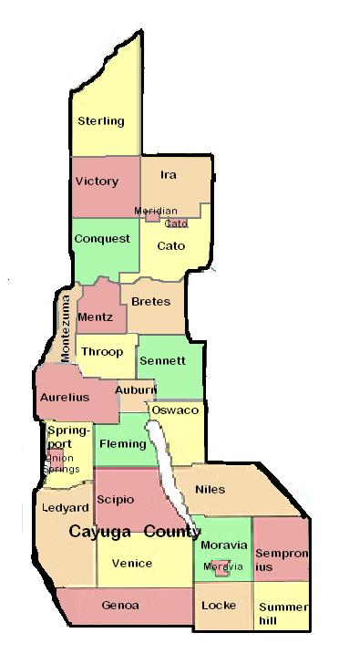
Cayuga County, New York
Encyclopedia
Cayuga County is a county located in the U.S. state
of New York
. It was named for one of the tribes of Indians in the Iroquois
Confederation. Its county seat
is Auburn
.
in 1683, the present Cayuga County was part of Albany County
. This was an enormous county, including the northern part of the present state of New York and all of the present state of Vermont
and, in theory, extending westward to the Pacific Ocean
. This county was reduced in size on July 3, 1766 by the creation of Cumberland County
, and further on March 16, 1770, by the creation of Gloucester County
, both containing territory now in Vermont.
On March 12, 1772, what was left of Albany County was split into three parts, one remaining under the name Albany County. One of the other pieces, Tryon County
, contained the western portion (and thus, since no western boundary was specified, theoretically still extended west to the Pacific). The eastern boundary of Tryon County was approximately five miles west of the present city of Schenectady
, and the county included the western part of the Adirondack Mountains
and the area west of the West Branch of the Delaware River
. The area then designated as Tryon County now includes 37 counties of New York State. The county was named for William Tryon
, colonial governor of New York.
In the years prior to 1776, most of the Loyalists in Tryon County fled to Canada
. In 1784, following the peace treaty that ended the American Revolutionary War
, the name of Tryon County was changed to Montgomery County
in honor of the general, Richard Montgomery
, who had captured several places in Canada and died attempting to capture the city of Quebec
, replacing the name of the hated British governor.
In 1789, Montgomery County was reduced in size by the splitting off of Ontario County
. The actual area split off from Montgomery County was much larger than the present county, also including the present Allegany
, Cattaraugus
, Chautauqua
, Erie
, Genesee
, Livingston
, Monroe
, Niagara
, Orleans
, Steuben
, Wyoming
, Yates
, and part of Schuyler
and Wayne Counties
. Harriet Tubman visited Auburn, New York
, located in Cayuga County, in 1887 with her daughter (adopted) and her 2nd husband.
Herkimer County
was one of three counties split off from Montgomery County (the others being Otsego
and Tioga Counties
) in 1791.
Onondaga County
was formed in 1794 by the splitting of Herkimer County.
Cayuga County was formed in 1799 by the splitting of Onondaga County. This county was, however, much larger than the present Cayuga County. It then included the present Seneca
and Tompkins Counties
.
In 1804, Seneca County was formed by the splitting of Cayuga County. Then in 1817, in turn, a portion of Seneca County was combined with a piece of the remainder of Cayuga County to form Tompkins County.
region. Owasco Lake
is in the center of the county, and Cayuga Lake
forms part of the western boundary. Lake Ontario
is on the northern border, and Skaneateles Lake
is at the eastern border. Cayuga County has more waterfront land than any other county in the state not adjacent to the Atlantic Ocean
.
 According to the U.S. Census Bureau, the county has a total area of 864 square miles (2,237.7 km²), of which 693 square miles (1,794.9 km²) is land and 170 square miles (440.3 km²) (19.74%) is water.
of 2000, there were 81,963 people, 30,558 households, and 20,840 families residing in the county. The population density
was 118 people per square mile (46/km²). There were 35,477 housing units at an average density of 51 per square mile (20/km²). The racial makeup of the county was 93.34% White
, 3.99% Black
or African American
, 0.31% Native American
, 0.42% Asian
, 0.02% Pacific Islander
, 0.88% from other races
, and 1.03% from two or more races. 1.97% of the population were Hispanic or Latino
of any race. 16.3% were of Irish
, 16.0% English
, 15.7% Italian
, 11.3% German
, 9.5% American
and 6.3% Polish ancestry according to Census 2000 http://factfinder.census.gov/servlet/DTTable?_bm=y&-context=dt&-ds_name=DEC_2000_SF3_U&-mt_name=DEC_2000_SF3_U_PCT016&-CONTEXT=dt&-tree_id=. 94.9% spoke English
, 2.0% Spanish
and 1.0% Italian
as their first language.
There were 30,558 households out of which 32.60% had children under the age of 18 living with them, 52.00% were married couples
living together, 11.00% had a female householder with no husband present, and 31.80% were non-families. 26.20% of all households were made up of individuals and 11.90% had someone living alone who was 65 years of age or older. The average household size was 2.53 and the average family size was 3.04.
In the county the population was spread out with 25.10% under the age of 18, 8.20% from 18 to 24, 29.70% from 25 to 44, 22.60% from 45 to 64, and 14.40% who were 65 years of age or older. The median age was 37 years. For every 100 females there were 102.20 males. For every 100 females age 18 and over, there were 101.80 males.
The median income for a household in the county was $37,487, and the median income for a family was $44,973. Males had a median income of $33,356 versus $23,919 for females. The per capita income
for the county was $18,003. About 7.80% of families and 11.10% of the population were below the poverty line, including 14.90% of those under age 18 and 8.20% of those age 65 or over.
defeated John Kerry
by a margin of only 0.58% or 49.22% to 48.64%. In statewide elections it has gone for Democrats both Eliot Spitzer and Hillary Clinton won it in 2006 with over 60% of the vote. In 2008 it was won by Democrat Barack Obama
with 53% of the vote to Republican John McCain
's 45%. In 2010 Democrat Andrew Cuomo
defeated Republican Carl Paladino
53% to 40% with 3% going to Green Party candidate Howie Hawkins. Also in 2010 both Senators Kirsten Gillibrand
and Chuck Schumer carried Cayuga County. Gillibrand won 54% of the vote while Schumer won 61%.
The Cayuga County Legislature consists of 15 members each of whom are elected from individual districts.
U.S. state
A U.S. state is any one of the 50 federated states of the United States of America that share sovereignty with the federal government. Because of this shared sovereignty, an American is a citizen both of the federal entity and of his or her state of domicile. Four states use the official title of...
of New York
New York
New York is a state in the Northeastern region of the United States. It is the nation's third most populous state. New York is bordered by New Jersey and Pennsylvania to the south, and by Connecticut, Massachusetts and Vermont to the east...
. It was named for one of the tribes of Indians in the Iroquois
Iroquois
The Iroquois , also known as the Haudenosaunee or the "People of the Longhouse", are an association of several tribes of indigenous people of North America...
Confederation. Its county seat
County seat
A county seat is an administrative center, or seat of government, for a county or civil parish. The term is primarily used in the United States....
is Auburn
Auburn, New York
Auburn is a city in Cayuga County, New York, United States of America. As of the 2010 census, the city had a population of 27,687...
.
History
When counties were established in the Province of New YorkProvince of New York
The Province of New York was an English and later British crown territory that originally included all of the present U.S. states of New York, New Jersey, Delaware and Vermont, along with inland portions of Connecticut, Massachusetts, and Maine, as well as eastern Pennsylvania...
in 1683, the present Cayuga County was part of Albany County
Albany County, New York
Albany County is a county located in the U.S. state of New York, and is part of the Albany-Schenectady-Troy Metropolitan Statistical Area. The name is from the title of the Duke of York and Albany, who became James II of England . As of the 2010 census, the population was 304,204...
. This was an enormous county, including the northern part of the present state of New York and all of the present state of Vermont
Vermont
Vermont is a state in the New England region of the northeastern United States of America. The state ranks 43rd in land area, , and 45th in total area. Its population according to the 2010 census, 630,337, is the second smallest in the country, larger only than Wyoming. It is the only New England...
and, in theory, extending westward to the Pacific Ocean
Pacific Ocean
The Pacific Ocean is the largest of the Earth's oceanic divisions. It extends from the Arctic in the north to the Southern Ocean in the south, bounded by Asia and Australia in the west, and the Americas in the east.At 165.2 million square kilometres in area, this largest division of the World...
. This county was reduced in size on July 3, 1766 by the creation of Cumberland County
Cumberland County, New York
Cumberland County, New York was a county in the Province of New York that became part of the state of Vermont. It was divided out of Albany County in New York in 1766, but eventually became part of Vermont in 1777...
, and further on March 16, 1770, by the creation of Gloucester County
Gloucester County, New York
Gloucester County, New York is a former county in New York that became part of the state of Vermont. It was a part of Albany County in the Province of New York until 1770 and was lost to Vermont in 1777. At that time, Vermont was holding itself out as the Republic of Vermont and did not become a...
, both containing territory now in Vermont.
On March 12, 1772, what was left of Albany County was split into three parts, one remaining under the name Albany County. One of the other pieces, Tryon County
Tryon County, New York
Tryon County, New York was a county in the colonial Province of New York in the British American colonies. It was created from Albany County on March 24, 1772. It was named for William Tryon, the last provincial governor of New York. Its boundaries extended far further than any current county...
, contained the western portion (and thus, since no western boundary was specified, theoretically still extended west to the Pacific). The eastern boundary of Tryon County was approximately five miles west of the present city of Schenectady
Schenectady, New York
Schenectady is a city in Schenectady County, New York, United States, of which it is the county seat. As of the 2010 census, the city had a population of 66,135...
, and the county included the western part of the Adirondack Mountains
Adirondack Mountains
The Adirondack Mountains are a mountain range located in the northeastern part of New York, that runs through Clinton, Essex, Franklin, Fulton, Hamilton, Herkimer, Lewis, Saint Lawrence, Saratoga, Warren, and Washington counties....
and the area west of the West Branch of the Delaware River
Delaware River
The Delaware River is a major river on the Atlantic coast of the United States.A Dutch expedition led by Henry Hudson in 1609 first mapped the river. The river was christened the South River in the New Netherland colony that followed, in contrast to the North River, as the Hudson River was then...
. The area then designated as Tryon County now includes 37 counties of New York State. The county was named for William Tryon
William Tryon
William Tryon was a British soldier and colonial administrator who served as governor of the Province of North Carolina and the Province of New York .-Early life and career:...
, colonial governor of New York.
In the years prior to 1776, most of the Loyalists in Tryon County fled to Canada
Canada
Canada is a North American country consisting of ten provinces and three territories. Located in the northern part of the continent, it extends from the Atlantic Ocean in the east to the Pacific Ocean in the west, and northward into the Arctic Ocean...
. In 1784, following the peace treaty that ended the American Revolutionary War
American Revolutionary War
The American Revolutionary War , the American War of Independence, or simply the Revolutionary War, began as a war between the Kingdom of Great Britain and thirteen British colonies in North America, and ended in a global war between several European great powers.The war was the result of the...
, the name of Tryon County was changed to Montgomery County
Montgomery County, New York
As of the census of 2000, there were 49,708 people, 20,038 households, and 13,104 families residing in the county. The population density was 123 people per square mile . There were 22,522 housing units at an average density of 56 per square mile...
in honor of the general, Richard Montgomery
Richard Montgomery
Richard Montgomery was an Irish-born soldier who first served in the British Army. He later became a brigadier-general in the Continental Army during the American Revolutionary War and he is most famous for leading the failed 1775 invasion of Canada.Montgomery was born and raised in Ireland...
, who had captured several places in Canada and died attempting to capture the city of Quebec
Quebec
Quebec or is a province in east-central Canada. It is the only Canadian province with a predominantly French-speaking population and the only one whose sole official language is French at the provincial level....
, replacing the name of the hated British governor.
In 1789, Montgomery County was reduced in size by the splitting off of Ontario County
Ontario County, New York
As of the census of 2000, there were 100,224 people, 38,370 households, and 26,360 families residing in the county. The population density was 156 people per square mile . There were 42,647 housing units at an average density of 66 per square mile...
. The actual area split off from Montgomery County was much larger than the present county, also including the present Allegany
Allegany County, New York
Allegany County is a county located in the U.S. state of New York. As of the 2010 census, the population was 48,946. Its name derives from a Delaware Indian word, applied by settlers of Western New York State to a trail that followed the Allegheny River. Its county seat is...
, Cattaraugus
Cattaraugus County, New York
Cattaraugus County is a county located in the U.S. state of New York. As of the 2010 census, the population was 80,317. The county seat is Little Valley.-History:...
, Chautauqua
Chautauqua County, New York
-Major highways:* Interstate 86/New York State Route 17 * Interstate 90 * U.S. Route 20* U.S. Route 62* New York State Route 5* New York State Route 39* New York State Route 60* New York State Route 394...
, Erie
Erie County, New York
Erie County is a county located in the U.S. state of New York. As of the 2010 census, the population was 919,040. The county seat is Buffalo. The county's name comes from Lake Erie, which in turn comes from the Erie tribe of American Indians who lived south and east of the lake before 1654.Erie...
, Genesee
Genesee County, New York
Genesee County is a county located in Western New York, United States. As of the 2010 census, the population was 60,079. Its name is from the Seneca Indian word Gen-nis'-hee-yo meaning "The Beautiful Valley." Its county seat is Batavia.- History :...
, Livingston
Livingston County, New York
As of the census of 2000, there were 64,328 people, 22,150 households, and 15,349 families residing in the county. The population density was 102 people per square mile . There were 24,023 housing units at an average density of 38 per square mile...
, Monroe
Monroe County, New York
Monroe County is a county located in the U.S. state of New York. As of the 2010 census, the population was 744,344. It is named after James Monroe, fifth President of the United States of America. Its county seat is the city of Rochester....
, Niagara
Niagara County, New York
Niagara County is a county located in the U.S. state of New York. As of the 2010 census, the population was 216,469. The county seat is Lockport. The county name is from the Iroquois word Onguiaahra; meaning the strait or thunder of waters. It is the location of Niagara Falls and Fort Niagara, and...
, Orleans
Orleans County, New York
As of the census of 2000, there were 44,171 people, 15,363 households, and 10,846 families residing in the county. The population density was 113 people per square mile . There were 17,347 housing units at an average density of 44 per square mile...
, Steuben
Steuben County, New York
Steuben County is a county located in the U.S. state of New York. As of the 2010 census, the population was 98,990. Its name is in honor of Baron von Steuben, a German general who fought on the American side in the American Revolutionary War, though it is not pronounced the same...
, Wyoming
Wyoming County, New York
Wyoming County is a county located in the U.S. state of New York. At the 2010 census, the population was 42,155. The county seat is Warsaw. The name is from a modified Delaware Indian word meaning "broad bottom lands"...
, Yates
Yates County, New York
Yates County is a county located in the U.S. state of New York. As of the 2010 census, the population was 25,348. The county seat is Penn Yan. The name is in honor of Joseph C. Yates, who as Governor of New York signed the act establishing the county....
, and part of Schuyler
Schuyler County, New York
As of the census of 2000, there were 19,224 people, 7,374 households, and 5,191 families residing in the county. The population density was 58 people per square mile . There were 9,181 housing units at an average density of 28 per square mile...
and Wayne Counties
Wayne County, New York
Wayne County is a county located in the US state of New York. It is part of the Rochester, New York Metropolitan Statistical Area and lies on the south shore of Lake Ontario, forming part of the northern border of the United States with Canada. The name honors General Anthony Wayne, an American...
. Harriet Tubman visited Auburn, New York
Auburn, New York
Auburn is a city in Cayuga County, New York, United States of America. As of the 2010 census, the city had a population of 27,687...
, located in Cayuga County, in 1887 with her daughter (adopted) and her 2nd husband.
Herkimer County
Herkimer County, New York
Herkimer County is a county located in the U.S. state of New York. It was created in 1791 north of the Mohawk River out of part of Montgomery County. As of the 2010 census, the population was 64,519. It is named after General Nicholas Herkimer, who died from battle wounds in 1777 after taking part...
was one of three counties split off from Montgomery County (the others being Otsego
Otsego County, New York
Otsego County is a county located in the U.S. state of New York. The 2010 population was 62,259. The county seat is Cooperstown. The name Otsego is from a Mohawk word meaning "place of the rock."-History:...
and Tioga Counties
Tioga County, New York
As of the census of 2010, there were 51,125 people residing in the county, with 22,203 housing units, of these 20,350 occupied, 1,853 vacant. The population density was 98 people per square mile...
) in 1791.
Onondaga County
Onondaga County, New York
Onondaga County is a county located in the U.S. state of New York. As of the 2010 census, the population was 467,026. The county seat is Syracuse.Onondaga County is part of the Syracuse, NY Metropolitan Statistical Area....
was formed in 1794 by the splitting of Herkimer County.
Cayuga County was formed in 1799 by the splitting of Onondaga County. This county was, however, much larger than the present Cayuga County. It then included the present Seneca
Seneca County, New York
As of the census of 2000, there were 33,342 people, 12,630 households, and 8,626 families residing in the county. The population density was 103 people per square mile . There were 14,794 housing units at an average density of 46 per square mile...
and Tompkins Counties
Tompkins County, New York
Tompkins County is a county located in the U.S. state of New York, and comprises the whole of the Ithaca metropolitan area. As of the 2010 census, the population was 101,564. The county seat is Ithaca, and the county is home to Cornell University, Ithaca College and Tompkins Cortland Community...
.
In 1804, Seneca County was formed by the splitting of Cayuga County. Then in 1817, in turn, a portion of Seneca County was combined with a piece of the remainder of Cayuga County to form Tompkins County.
Geography
Cayuga County is located in the west central part of the state, in the Finger LakesFinger Lakes
The Finger Lakes are a pattern of lakes in the west-central section of Upstate New York in the United States. They are a popular tourist destination. The lakes are long and thin , each oriented roughly on a north-south axis. The two longest, Cayuga Lake and Seneca Lake, are among the deepest in...
region. Owasco Lake
Owasco Lake
Owasco Lake is the sixth largest and third easternmost of the Finger Lakes of New York in the United States of America . The name Owasco can be roughly translated from a Mohawk and Iroquois term meaning "crossing"....
is in the center of the county, and Cayuga Lake
Cayuga Lake
Cayuga Lake is the longest of central New York's glacial Finger Lakes, and is the second largest in surface area and second largest in volume. It is just under 40 miles long. Its average width is 1.7 miles , and it is at its widest point near Aurora...
forms part of the western boundary. Lake Ontario
Lake Ontario
Lake Ontario is one of the five Great Lakes of North America. It is bounded on the north and southwest by the Canadian province of Ontario, and on the south by the American state of New York. Ontario, Canada's most populous province, was named for the lake. In the Wyandot language, ontarío means...
is on the northern border, and Skaneateles Lake
Skaneateles Lake
Skaneateles Lake is one of the Finger Lakes in central New York in the United States. The name Skaneateles means long lake in one of the local Iroquoian languages. The lake is sometimes referred to as "The Roof Garden of the Lakes" because its altitude is higher than the other Finger Lakes. It...
is at the eastern border. Cayuga County has more waterfront land than any other county in the state not adjacent to the Atlantic Ocean
Atlantic Ocean
The Atlantic Ocean is the second-largest of the world's oceanic divisions. With a total area of about , it covers approximately 20% of the Earth's surface and about 26% of its water surface area...
.
Adjacent counties
- Oswego CountyOswego County, New YorkOswego County is a county located in the U.S. state of New York. As of the 2010 Census, the estimated population was 122,109. The City of Oswego and the Village of Pulaski serve as the dual county seats in a two shire system of government...
, New YorkNew YorkNew York is a state in the Northeastern region of the United States. It is the nation's third most populous state. New York is bordered by New Jersey and Pennsylvania to the south, and by Connecticut, Massachusetts and Vermont to the east...
- northeast - Onondaga CountyOnondaga County, New YorkOnondaga County is a county located in the U.S. state of New York. As of the 2010 census, the population was 467,026. The county seat is Syracuse.Onondaga County is part of the Syracuse, NY Metropolitan Statistical Area....
, New YorkNew YorkNew York is a state in the Northeastern region of the United States. It is the nation's third most populous state. New York is bordered by New Jersey and Pennsylvania to the south, and by Connecticut, Massachusetts and Vermont to the east...
- east - Cortland CountyCortland County, New YorkCortland County is a county located in the U.S. state of New York, named after Federico Van Cortlandt, president of the convention at Kingston that wrote the first New York State Constitution in 1777, and first lieutenant governor of the state. The county seat is Cortland...
, New YorkNew YorkNew York is a state in the Northeastern region of the United States. It is the nation's third most populous state. New York is bordered by New Jersey and Pennsylvania to the south, and by Connecticut, Massachusetts and Vermont to the east...
- southeast - Tompkins CountyTompkins County, New YorkTompkins County is a county located in the U.S. state of New York, and comprises the whole of the Ithaca metropolitan area. As of the 2010 census, the population was 101,564. The county seat is Ithaca, and the county is home to Cornell University, Ithaca College and Tompkins Cortland Community...
, New YorkNew YorkNew York is a state in the Northeastern region of the United States. It is the nation's third most populous state. New York is bordered by New Jersey and Pennsylvania to the south, and by Connecticut, Massachusetts and Vermont to the east...
- south - Seneca CountySeneca County, New YorkAs of the census of 2000, there were 33,342 people, 12,630 households, and 8,626 families residing in the county. The population density was 103 people per square mile . There were 14,794 housing units at an average density of 46 per square mile...
, New YorkNew YorkNew York is a state in the Northeastern region of the United States. It is the nation's third most populous state. New York is bordered by New Jersey and Pennsylvania to the south, and by Connecticut, Massachusetts and Vermont to the east...
- west - Wayne CountyWayne County, New YorkWayne County is a county located in the US state of New York. It is part of the Rochester, New York Metropolitan Statistical Area and lies on the south shore of Lake Ontario, forming part of the northern border of the United States with Canada. The name honors General Anthony Wayne, an American...
, New YorkNew YorkNew York is a state in the Northeastern region of the United States. It is the nation's third most populous state. New York is bordered by New Jersey and Pennsylvania to the south, and by Connecticut, Massachusetts and Vermont to the east...
- west
Major highways
 Interstate 90Interstate 90Interstate 90 is the longest Interstate Highway in the United States at . It is the northernmost coast-to-coast interstate, and parallels US 20 for the most part. Its western terminus is in Seattle, at Edgar Martinez Drive S. near Safeco Field and CenturyLink Field, and its eastern terminus is in...
(New York State ThruwayNew York State ThruwayThe New York State Thruway is a system of limited-access highways located within the state of New York in the United States. The system, known officially as the Governor Thomas E. Dewey Thruway for former New York Governor Thomas E. Dewey, is operated by the New York State Thruway Authority and...
) U.S. Route 20U.S. Route 20 in New YorkU.S. Route 20 is a part of the U.S. Highway System that runs from Newport, Oregon, to Boston, Massachusetts. In the U.S. state of New York, US 20 extends from the Pennsylvania state line at Ripley to the Massachusetts state line in the Berkshire Mountains. US 20 is the longest...
 New York State Route 5New York State Route 5New York State Route 5 is a state highway that extends for across the state of New York in the United States. It begins at the Pennsylvania state line in the Chautauqua County town of Ripley and passes through Buffalo, Syracuse, Utica, Schenectady, and several other smaller cities and...
 New York State Route 31New York State Route 31New York State Route 31 is a state highway that extends for across western and central New York in the United States. The western terminus of the route is at an intersection with NY 104 in the city of Niagara Falls. Its eastern terminus is at a traffic circle with NY 26 in Vernon...
 New York State Route 34New York State Route 34New York State Route 34 is a north–south New York state route located in Central New York. Its southern terminus is at the Pennsylvania state line in the village of Waverly, where it connects to Pennsylvania Route 199 and meets NY 17...
 New York State Route 38New York State Route 38New York State Route 38 is a north–south state highway in the Finger Lakes region of New York in the United States. Its southern terminus is at an intersection with NY 96 in the town of Owego in Tioga County. The northern terminus is at a junction with NY 104A in the town of...
 New York State Route 90New York State Route 90New York State Route 90 is a north–south state highway in the Finger Lakes region of New York, United States. All but five of the route's are located in Cayuga County, with the remaining situated in Cortland County. The southern terminus of the route is at an intersection with U.S....
 New York State Route 104New York State Route 104New York State Route 104 is a long east–west state highway in Upstate New York, United States. It spans six counties and enters the vicinity of four cities—Niagara Falls, Lockport, Rochester, and Oswego—as it follows a routing largely parallel to that of the southern shoreline of Lake...
Demographics
As of the censusCensus
A census is the procedure of systematically acquiring and recording information about the members of a given population. It is a regularly occurring and official count of a particular population. The term is used mostly in connection with national population and housing censuses; other common...
of 2000, there were 81,963 people, 30,558 households, and 20,840 families residing in the county. The population density
Population density
Population density is a measurement of population per unit area or unit volume. It is frequently applied to living organisms, and particularly to humans...
was 118 people per square mile (46/km²). There were 35,477 housing units at an average density of 51 per square mile (20/km²). The racial makeup of the county was 93.34% White
Race (United States Census)
Race and ethnicity in the United States Census, as defined by the Federal Office of Management and Budget and the United States Census Bureau, are self-identification data items in which residents choose the race or races with which they most closely identify, and indicate whether or not they are...
, 3.99% Black
Race (United States Census)
Race and ethnicity in the United States Census, as defined by the Federal Office of Management and Budget and the United States Census Bureau, are self-identification data items in which residents choose the race or races with which they most closely identify, and indicate whether or not they are...
or African American
Race (United States Census)
Race and ethnicity in the United States Census, as defined by the Federal Office of Management and Budget and the United States Census Bureau, are self-identification data items in which residents choose the race or races with which they most closely identify, and indicate whether or not they are...
, 0.31% Native American
Race (United States Census)
Race and ethnicity in the United States Census, as defined by the Federal Office of Management and Budget and the United States Census Bureau, are self-identification data items in which residents choose the race or races with which they most closely identify, and indicate whether or not they are...
, 0.42% Asian
Race (United States Census)
Race and ethnicity in the United States Census, as defined by the Federal Office of Management and Budget and the United States Census Bureau, are self-identification data items in which residents choose the race or races with which they most closely identify, and indicate whether or not they are...
, 0.02% Pacific Islander
Race (United States Census)
Race and ethnicity in the United States Census, as defined by the Federal Office of Management and Budget and the United States Census Bureau, are self-identification data items in which residents choose the race or races with which they most closely identify, and indicate whether or not they are...
, 0.88% from other races
Race (United States Census)
Race and ethnicity in the United States Census, as defined by the Federal Office of Management and Budget and the United States Census Bureau, are self-identification data items in which residents choose the race or races with which they most closely identify, and indicate whether or not they are...
, and 1.03% from two or more races. 1.97% of the population were Hispanic or Latino
Race (United States Census)
Race and ethnicity in the United States Census, as defined by the Federal Office of Management and Budget and the United States Census Bureau, are self-identification data items in which residents choose the race or races with which they most closely identify, and indicate whether or not they are...
of any race. 16.3% were of Irish
Irish people
The Irish people are an ethnic group who originate in Ireland, an island in northwestern Europe. Ireland has been populated for around 9,000 years , with the Irish people's earliest ancestors recorded having legends of being descended from groups such as the Nemedians, Fomorians, Fir Bolg, Tuatha...
, 16.0% English
English people
The English are a nation and ethnic group native to England, who speak English. The English identity is of early mediaeval origin, when they were known in Old English as the Anglecynn. England is now a country of the United Kingdom, and the majority of English people in England are British Citizens...
, 15.7% Italian
Italian people
The Italian people are an ethnic group that share a common Italian culture, ancestry and speak the Italian language as a mother tongue. Within Italy, Italians are defined by citizenship, regardless of ancestry or country of residence , and are distinguished from people...
, 11.3% German
Germans
The Germans are a Germanic ethnic group native to Central Europe. The English term Germans has referred to the German-speaking population of the Holy Roman Empire since the Late Middle Ages....
, 9.5% American
United States
The United States of America is a federal constitutional republic comprising fifty states and a federal district...
and 6.3% Polish ancestry according to Census 2000 http://factfinder.census.gov/servlet/DTTable?_bm=y&-context=dt&-ds_name=DEC_2000_SF3_U&-mt_name=DEC_2000_SF3_U_PCT016&-CONTEXT=dt&-tree_id=. 94.9% spoke English
English language
English is a West Germanic language that arose in the Anglo-Saxon kingdoms of England and spread into what was to become south-east Scotland under the influence of the Anglian medieval kingdom of Northumbria...
, 2.0% Spanish
Spanish language
Spanish , also known as Castilian , is a Romance language in the Ibero-Romance group that evolved from several languages and dialects in central-northern Iberia around the 9th century and gradually spread with the expansion of the Kingdom of Castile into central and southern Iberia during the...
and 1.0% Italian
Italian language
Italian is a Romance language spoken mainly in Europe: Italy, Switzerland, San Marino, Vatican City, by minorities in Malta, Monaco, Croatia, Slovenia, France, Libya, Eritrea, and Somalia, and by immigrant communities in the Americas and Australia...
as their first language.
There were 30,558 households out of which 32.60% had children under the age of 18 living with them, 52.00% were married couples
Marriage
Marriage is a social union or legal contract between people that creates kinship. It is an institution in which interpersonal relationships, usually intimate and sexual, are acknowledged in a variety of ways, depending on the culture or subculture in which it is found...
living together, 11.00% had a female householder with no husband present, and 31.80% were non-families. 26.20% of all households were made up of individuals and 11.90% had someone living alone who was 65 years of age or older. The average household size was 2.53 and the average family size was 3.04.
In the county the population was spread out with 25.10% under the age of 18, 8.20% from 18 to 24, 29.70% from 25 to 44, 22.60% from 45 to 64, and 14.40% who were 65 years of age or older. The median age was 37 years. For every 100 females there were 102.20 males. For every 100 females age 18 and over, there were 101.80 males.
The median income for a household in the county was $37,487, and the median income for a family was $44,973. Males had a median income of $33,356 versus $23,919 for females. The per capita income
Per capita income
Per capita income or income per person is a measure of mean income within an economic aggregate, such as a country or city. It is calculated by taking a measure of all sources of income in the aggregate and dividing it by the total population...
for the county was $18,003. About 7.80% of families and 11.10% of the population were below the poverty line, including 14.90% of those under age 18 and 8.20% of those age 65 or over.
Government and politics
Cayuga County is considered a swing county in national elections. In 2000 Democrat Al Gore won Cayuga County with 50% of the vote to Bush's 44. In 2004 however Republican George W. BushGeorge W. Bush
George Walker Bush is an American politician who served as the 43rd President of the United States, from 2001 to 2009. Before that, he was the 46th Governor of Texas, having served from 1995 to 2000....
defeated John Kerry
John Kerry
John Forbes Kerry is the senior United States Senator from Massachusetts, the 10th most senior U.S. Senator and chairman of the Senate Foreign Relations Committee. He was the presidential nominee of the Democratic Party in the 2004 presidential election, but lost to former President George W...
by a margin of only 0.58% or 49.22% to 48.64%. In statewide elections it has gone for Democrats both Eliot Spitzer and Hillary Clinton won it in 2006 with over 60% of the vote. In 2008 it was won by Democrat Barack Obama
Barack Obama
Barack Hussein Obama II is the 44th and current President of the United States. He is the first African American to hold the office. Obama previously served as a United States Senator from Illinois, from January 2005 until he resigned following his victory in the 2008 presidential election.Born in...
with 53% of the vote to Republican John McCain
John McCain
John Sidney McCain III is the senior United States Senator from Arizona. He was the Republican nominee for president in the 2008 United States election....
's 45%. In 2010 Democrat Andrew Cuomo
Andrew Cuomo
Andrew Mark Cuomo is the 56th and current Governor of New York, having assumed office on January 1, 2011. A member of the Democratic Party, he was the 64th New York State Attorney General, and was the 11th United States Secretary of Housing and Urban Development...
defeated Republican Carl Paladino
Carl Paladino
Carl Pasquale Paladino is an American businessman and political activist from Buffalo, New York. Paladino is the founder and chairman of Ellicott Development Company, a real estate development company he founded in 1973. He was the 2010 Republican nominee for the New York gubernatorial election,...
53% to 40% with 3% going to Green Party candidate Howie Hawkins. Also in 2010 both Senators Kirsten Gillibrand
Kirsten Gillibrand
Kirsten Elizabeth Rutnik Gillibrand is an attorney and the junior United States Senator from the state of New York and a member of the Democratic Party...
and Chuck Schumer carried Cayuga County. Gillibrand won 54% of the vote while Schumer won 61%.
The Cayuga County Legislature consists of 15 members each of whom are elected from individual districts.
See also
- USS Cayuga County (LST-529)USS Cayuga County (LST-529)USS Cayuga County was an built for the United States Navy during World War II. Named for Cayuga County, New York, she was the only U.S. Naval vessel to bear the name....
- Cayuga County Sheriff's Office
- Cayuga County Community CollegeCayuga County Community CollegeCayuga Community College, formerly Cayuga County Community College, is a two year SUNY college in Cayuga County, New York. The college began in 1953 as Auburn Community College. Its main campus is in Auburn, New York...
- Cayuga Community College Office of Public SafetyCayuga Community College Office of Public SafetyThe Cayuga Community College Office of Public Safety is a law enforcement entity consisting of sworn peace officers who have taken an oath to serve and protect both the Auburn Main Campus located in Cayuga County, NY, and the Fulton Branch Campus located in Oswego County, NY...
- List of counties in New York
- National Register of Historic Places listings in Cayuga County, New York
External links
- County of Cayuga
- Cayuga County NYGenWeb Project
- Cayuga County history pages
- Summary early history of counties and towns of Cayuga County
- Area photos, maps, history and genealogy
- Cayuga County Sheriff
- Cayuga Community College
- Cayuga County Historical Aerial Photographs of New York , Cornell University Library & Cornell Institute for Resource Information Sciences
- Genealogy and history resources for Cayuga County