
New York State Route 63
Encyclopedia
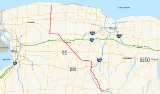
New York State Route 63 (NY 63) is a state highway
in the western part of New York
in the United States. The southern terminus of the route is at an intersection with NY 15
and NY 21
in the village of Wayland
in Steuben County
. Its northern end is at a junction with NY 18
in the town of Yates
in Orleans County
, 2 miles (3.2 km) south of the Lake Ontario
shoreline. NY 63, which follows more of a southeast–northwesterly alignment for much of its routing, passes through the city of Batavia
and enters or comes near several villages, including Dansville
and Medina
.
NY 63 was assigned as part of the 1930 renumbering of state highways in New York, but to a largely different routing than it follows today. The original alignment of NY 63 was identical to its current alignment between Mount Morris
and Pavilion
; however, the route deviated significantly from its modern routing past those points as it extended southwest from Mount Morris to Hinsdale
and north from Pavilion to Hamlin
. It was rerouted north of Pavilion ca. 1939 and south of Mount Morris in the early 1940s. The latter realignment supplanted New York State Route 36A, a Dansville – Mount Morris highway assigned in 1930. For a brief period during the 1970s, NY 63 began in Dansville instead of Wayland.
and NY 21
in the northern Steuben County
village of Wayland
. From here it heads west, paralleling Interstate 390 (I-390) on the side of the valley the interstate travels through. It enters Livingston County
and the village of Dansville
, where it briefly shares a street with NY 36
, which at this point parallels I-390 on its other side for most of its route. NY 256
splits off for Conesus Lake
in Dansville as well.
Continuing north into Groveland
, the short remnant of NY 258
comes in from the west at the town line. At the north end the highway runs much closer to I-390, and indirectly connects to the expressway by way of NY 408
. From this point north, the road becomes busier as NY 63 is the primary route to Geneseo for northbound traffic on I-390 itself, as there is no exit at the point where the expressway crosses under NY 63.
(US 20A) and NY 39
, NY 63 enters Geneseo from the south, passing the campus
of SUNY Geneseo
. At the edge of the village, the highway crosses the Genesee River
, then begins to curve up and out of the valley until it runs east–west again through the town of York
.
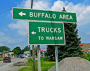
The major junction in York is the hamlet of Greigsville, where NY 63 intersects NY 36
. This next section of highway has become a major shortcut for traffic heading to the Buffalo
area, despite remaining a two-lane road through open rural country, since it is both physically shorter than going all the way to the New York State Thruway
as well as toll
-free, and especially for traffic headed to the communities east or south of Buffalo this route is actually preferable. Most of this Buffalo-bound traffic has followed NY 36 up from Mt. Morris
, and turns on to NY 63 here. Signage along this route reflects this use.
From Greigsville, the route heads east through open land, into a brief corner of Wyoming County
, where it turns to head due northwest, its direction for the next 30 miles (48 km). The next intersection with a state highway, the northern end of NY 246
, comes just after the Genesee County
line. A mile beyond, NY 63 drops down slightly to intersect with NY 19
at Pavilion
. After the traffic light
at the center of the hamlet, NY 63 crosses Oatka Creek
and climbs back up out of the Wyoming Valley. Atop the hill, it narrows again and continues due northwest to its next junction, the underdeveloped crossing of US 20
. Here at least some Buffalo-bound traffic will turn west. Eventually acquiring the name Ellicott Street, NY 63 finally enters Batavia
, where it intersects the two major east–west trunk routes in this corridor, NY 5
and NY 33
, as well as the north–south NY 98
, which connects to the Thruway just north of the city.
, where NY 262
departs to the east. Finally, just north of Oakfield, NY 63 turns due west on Judge Road and follows it several miles to NY 77
, which it joins north of Basom.
At Alabama
, NY 77 turns to the west and NY 63 continues northwards, across the Iroquois National Wildlife Refuge
and into Orleans County
, to reach Medina
. This village begins at a junction with NY 31
and NY 31A
. Route 31A continues eastward while NY 31 joins NY 63 through the village. The portion of the overlap between Starr and Center Streets is maintained by the village of Medina and is the only segment of NY 63 not maintained by the New York State Department of Transportation
. At Center Street, NY 31E
comes in from the west and NY 31 leaves NY 63 to continue east. Route 63 crosses the Erie Canal
, and leaves town. Several miles further on, at Ridgeway
, NY 63 crosses NY 104
. This penultimate east–west trunk road through the region is followed by a descent into the last village along the route, Lyndonville
. A short distance past it, Route 63 reaches its northern terminus at NY 18
.
(at Hampton Corners) and Pavilion
. South of Mount Morris, the route followed what is now NY 408
to Dalton and continued south on Old State Road and west on Allegany County Route 16 (CR 16) to NY 19
west of the village of Angelica
. NY 63 overlapped NY 19 south to Belvidere, where NY 63 turned west onto modern CR 20. It continued west on CR 20 and NY 446
through Cuba
to a junction with NY 16
in Hinsdale
, where it ended. North of Pavilion, NY 63 followed modern NY 19
to the Lake Ontario
shoreline in Hamlin
.
The portion of what is now NY 63 north of Pavilion was designated as part of NY 19 in the 1930 renumbering. However, unlike current NY 63, NY 19 continued north for another 2 miles (3.2 km) on Lyndonville Road past NY 18
to the Lake Ontario shoreline. The routings of NY 19 and NY 63 north of Pavilion were swapped ca. 1939, placing both routes on their modern alignments. The portion of Lyndonville Road north of NY 18 remained part of NY 63 until April 1, 1989, when ownership and maintenance of the highway was transferred from the state of New York
to Orleans County
as part of a highway maintenance swap between the two levels of government. It was subsequently redesignated as CR 63-1.
South of Mount Morris, modern NY 63 was designated as NY 36A from Mount Morris to Dansville
and became part of NY 39
(later NY 245
) from Dansville to Wayland
in the 1930 renumbering. NY 63 was rerouted south of Mount Morris in the early 1940s to follow the former routing of NY 36A south to Dansville, from where it overlapped NY 245 east to Wayland. Ca. 1972, NY 245 was truncated northeastward to Naples
and NY 63 was cut back to NY 36 in Dansville, leaving the Dansville–Wayland highway as an unsigned reference route. This was partially reversed in the late 1970s or early 1980s when NY 63 was reextended to Wayland.
Prior to the 1930 renumbering, modern NY 63 was a mix of numbered and unnumbered highways, with three different routes (all assigned in the mid-1920s) occupying the numbered sections of the highway. From Wayland to Dansville, what is now NY 63 was originally designated as the westernmost part of NY 52. It was unnumbered from Dansville northwest to Hampton Corners, where NY 36
entered from the west on current NY 408
and followed the path of modern NY 63 to Geneseo. The road was unnumbered again until Pavilion
, at which point NY 62 joined from the south and utilized all of current NY 63 and CR 63-1 to reach the Lake Ontario shoreline in Yates.
 As part of a large scale study in the early 2000s, the New York State Department of Transportation
(NYSDOT) determined that NY 63 from Mount Morris
to Pavilion
, along with US 20
and NY 77
—termed the "Route 63 Corridor"—were major trouble routes, primarily because of increased truck traffic using the corridor as a bypass between I-390
in Mount Morris and the New York State Thruway
in Pembroke
.
The most publicized and perhaps most fought-over possibility mentioned was that of a new expressway from Mount Morris to Pembroke, bypassing these three routes. The Wyoming County
Chamber of Commerce was a driving force behind this, hoping interchanges in Perry
, Warsaw
and Attica
would promote business growth.
While residents along the Route 63 corridor are against the increased truck traffic along the corridor (spurred by the North American Free Trade Agreement
), most of those same residents, along with other groups, also fought the proposed expressway. The general consensus of all of these groups is that NYSDOT should impose restrictions on the Route 63 corridor and force trucks to remain on I-390 and the Thruway to travel between Buffalo
and Pennsylvania
.
has plans to slightly realign NY 63 via new construction to eliminate Peoria Curve, a sharp curve in the town of Covington
, which has been prone to accidents and can create problems for truckers in winter. The short sharp curve will be lengthened and softened via construction of a new intersection on Peoria Road north of the current intersection. The new intersection will be constructed first, with the new road being constructed to its junction points on NY 63. The route will be closed for approximately four weeks while the realignment is connected at those points. What capacity the former NY 63 will take on (reference route, county route, etc.) has not been specified yet. Construction is expected to take place during 2008, with a scheduled completion date of December 2008.
 NY 63A was an alternate route of NY 63 between Angelica
, Allegany County
, and Nunda
, Livingston County
. The route was assigned as part of the 1930 renumbering and redesignated as NY 408A in the early 1940s.
State highway
State highway, state road or state route can refer to one of three related concepts, two of them related to a state or provincial government in a country that is divided into states or provinces :#A...
in the western part of New York
New York
New York is a state in the Northeastern region of the United States. It is the nation's third most populous state. New York is bordered by New Jersey and Pennsylvania to the south, and by Connecticut, Massachusetts and Vermont to the east...
in the United States. The southern terminus of the route is at an intersection with NY 15
New York State Route 15
New York State Route 15 is a north–south state highway located in western New York in the United States. The southern terminus of the route is officially at Interstate 390 exit 3 south of the village of Wayland, although some signage indicating that NY 15 continues south to...
and NY 21
New York State Route 21
New York State Route 21 is a state highway extending for through the western part of New York in the United States. The southern terminus of the route is at NY 417 in Andover. The northern terminus is at NY 104 in Williamson...
in the village of Wayland
Wayland (village), New York
Wayland is a village in Steuben County, New York, United States. The population was 1,893 at the 2000 census.The Village of Wayland is in north part of the Town of Wayland, near the north border of Steuben County.- History :...
in Steuben County
Steuben County, New York
Steuben County is a county located in the U.S. state of New York. As of the 2010 census, the population was 98,990. Its name is in honor of Baron von Steuben, a German general who fought on the American side in the American Revolutionary War, though it is not pronounced the same...
. Its northern end is at a junction with NY 18
New York State Route 18
New York State Route 18 is an east–west state highway in western New York in the United States. It runs parallel to the south shore of Lake Ontario for most of its length between Niagara County and Monroe County...
in the town of Yates
Yates, New York
Yates is a town in Orleans County, New York, United States. The population was 2,510 at the 2000 census. The town in named after Joseph C. Yates, a governor of New York.The Town of Yates is in the northwest part of the county...
in Orleans County
Orleans County, New York
As of the census of 2000, there were 44,171 people, 15,363 households, and 10,846 families residing in the county. The population density was 113 people per square mile . There were 17,347 housing units at an average density of 44 per square mile...
, 2 miles (3.2 km) south of the Lake Ontario
Lake Ontario
Lake Ontario is one of the five Great Lakes of North America. It is bounded on the north and southwest by the Canadian province of Ontario, and on the south by the American state of New York. Ontario, Canada's most populous province, was named for the lake. In the Wyandot language, ontarío means...
shoreline. NY 63, which follows more of a southeast–northwesterly alignment for much of its routing, passes through the city of Batavia
Batavia (city), New York
Batavia is a city in Genesee County, Western New York, USA, located near the middle of Genesee County, entirely within the Town of Batavia. Its population as of the 2000 census was 16,256...
and enters or comes near several villages, including Dansville
Dansville, Livingston County, New York
Dansville is a village in the town of North Dansville in the eastern part of Livingston County, New York, United States. As of the census, the village population was 4,832. The village is named after Daniel Faulkner, an early settler. Interstate 390 passes next to the west side of the village.-...
and Medina
Medina, New York
Medina is a village in the towns of Shelby and Ridgeway in Orleans County, New York, United States. The population was 6,415 at the 2000 census, making it the second most populous municipality in the county after Albion, the county seat. The village was named by its surveyor...
.
NY 63 was assigned as part of the 1930 renumbering of state highways in New York, but to a largely different routing than it follows today. The original alignment of NY 63 was identical to its current alignment between Mount Morris
Mount Morris (town), New York
Mount Morris is a town in Livingston County, New York, United States. The population was 4,567 at the 2000 census. The town and village were named after Robert Morris, the financier of the American Revolution....
and Pavilion
Pavilion, New York
Pavilion is a town in Genesee County, New York, United States. The population was 2,467 at the 2000 census. The town was named after a hotel in Saratoga, New York by an early resident.The Town of Pavilion is in the southeast corner of Genesee County...
; however, the route deviated significantly from its modern routing past those points as it extended southwest from Mount Morris to Hinsdale
Hinsdale, New York
Hinsdale is a town in Cattaraugus County, New York, United States. The population was 2,270 at the 2000 census. The town was named after another location: Hinsdale, New Hampshire....
and north from Pavilion to Hamlin
Hamlin, New York
Hamlin is a town in Monroe County, New York, United States. The population was 9,045 at the 2010 census.The Town of Hamlin is in the northwest part of the county and is the second largest town in area in the county.- History :...
. It was rerouted north of Pavilion ca. 1939 and south of Mount Morris in the early 1940s. The latter realignment supplanted New York State Route 36A, a Dansville – Mount Morris highway assigned in 1930. For a brief period during the 1970s, NY 63 began in Dansville instead of Wayland.
Wayland to Geneseo
NY 63 begins at a four-way intersection with NY 15New York State Route 15
New York State Route 15 is a north–south state highway located in western New York in the United States. The southern terminus of the route is officially at Interstate 390 exit 3 south of the village of Wayland, although some signage indicating that NY 15 continues south to...
and NY 21
New York State Route 21
New York State Route 21 is a state highway extending for through the western part of New York in the United States. The southern terminus of the route is at NY 417 in Andover. The northern terminus is at NY 104 in Williamson...
in the northern Steuben County
Steuben County, New York
Steuben County is a county located in the U.S. state of New York. As of the 2010 census, the population was 98,990. Its name is in honor of Baron von Steuben, a German general who fought on the American side in the American Revolutionary War, though it is not pronounced the same...
village of Wayland
Wayland (village), New York
Wayland is a village in Steuben County, New York, United States. The population was 1,893 at the 2000 census.The Village of Wayland is in north part of the Town of Wayland, near the north border of Steuben County.- History :...
. From here it heads west, paralleling Interstate 390 (I-390) on the side of the valley the interstate travels through. It enters Livingston County
Livingston County, New York
As of the census of 2000, there were 64,328 people, 22,150 households, and 15,349 families residing in the county. The population density was 102 people per square mile . There were 24,023 housing units at an average density of 38 per square mile...
and the village of Dansville
Dansville, Livingston County, New York
Dansville is a village in the town of North Dansville in the eastern part of Livingston County, New York, United States. As of the census, the village population was 4,832. The village is named after Daniel Faulkner, an early settler. Interstate 390 passes next to the west side of the village.-...
, where it briefly shares a street with NY 36
New York State Route 36
New York State Route 36 is a north–south state highway in the western part of New York in the United States. The highway extends for from the Pennsylvania state line at Troupsburg, Steuben County northward to Ogden, Monroe County, where it ends at an intersection with NY 31...
, which at this point parallels I-390 on its other side for most of its route. NY 256
New York State Route 256
New York State Route 256 is a north–south state highway located within Livingston County, New York, in the United States. It extends for across mostly rural terrain from an intersection with NY 63 in the village of Dansville to a junction with NY 15 on the Geneseo–Livonia town line...
splits off for Conesus Lake
Conesus Lake
Conesus Lake is one of the minor Finger Lakes in western New York. It is western-most of eleven total Finger Lakes. The lake's outlet is in Lakeville, New York a hamlet in the Town of Livonia, New York in Livingston County, south of Rochester, New York. The lake's inlet is in the Town of Conesus,...
in Dansville as well.
Continuing north into Groveland
Groveland, New York
Groveland is a town in Livingston County, New York, United States. The population was 3,853 at the 2000 census.The Town of Groveland is centrally located in the county, south of Geneseo.- History :...
, the short remnant of NY 258
New York State Route 258
New York State Route 258 is a state highway located entirely within the town of Groveland in Livingston County, New York, United States. It connects NY 36 in the hamlet of Ross Corners to NY 63 in the hamlet of Groveland. NY 258 is named Flats Road and passes through the flat...
comes in from the west at the town line. At the north end the highway runs much closer to I-390, and indirectly connects to the expressway by way of NY 408
New York State Route 408
New York State Route 408 is a state highway located entirely within Livingston County, New York, in the United States. It runs north–south from an intersection with NY 70 near the hamlet of Dalton in the town of Nunda to a junction with NY 63 in the town of Groveland near...
. From this point north, the road becomes busier as NY 63 is the primary route to Geneseo for northbound traffic on I-390 itself, as there is no exit at the point where the expressway crosses under NY 63.
Geneseo to Batavia
After joining with U.S. Route 20AU.S. Route 20A (New York)
U.S. Route 20A is an east–west alternate route of US 20 that extends for across the western portion of New York in the United States. It leaves US 20 in Hamburg, a suburb of Buffalo, and rejoins it in East Bloomfield about five miles west of Canandaigua, the county seat of...
(US 20A) and NY 39
New York State Route 39
New York State Route 39 is an east–west state highway in the western portion of New York in the United States. It begins and ends at intersections with U.S. Route 20 apart...
, NY 63 enters Geneseo from the south, passing the campus
Campus
A campus is traditionally the land on which a college or university and related institutional buildings are situated. Usually a campus includes libraries, lecture halls, residence halls and park-like settings...
of SUNY Geneseo
State University of New York at Geneseo
The State University of New York at Geneseo—also known as SUNY Geneseo, Geneseo State, or, colloquially, Geneseo—is located in Geneseo, Livingston County, New York, United States. It is a University College of the State University of New York...
. At the edge of the village, the highway crosses the Genesee River
Genesee River
The Genesee River is a North American river flowing northward through the Twin Tiers of Pennsylvania and New York. The river provided the original power for the Rochester area's 19th century mills and still provides hydroelectric power for downtown Rochester....
, then begins to curve up and out of the valley until it runs east–west again through the town of York
York, New York
York is a town in western Livingston County, New York, United States. The population was 3,219 at the 2000 census.The Abbey of the Genesee in the town's hamlet of Piffard is locally famous due to the production of Monk's Bread.- History :...
.
The major junction in York is the hamlet of Greigsville, where NY 63 intersects NY 36
New York State Route 36
New York State Route 36 is a north–south state highway in the western part of New York in the United States. The highway extends for from the Pennsylvania state line at Troupsburg, Steuben County northward to Ogden, Monroe County, where it ends at an intersection with NY 31...
. This next section of highway has become a major shortcut for traffic heading to the Buffalo
Buffalo, New York
Buffalo is the second most populous city in the state of New York, after New York City. Located in Western New York on the eastern shores of Lake Erie and at the head of the Niagara River across from Fort Erie, Ontario, Buffalo is the seat of Erie County and the principal city of the...
area, despite remaining a two-lane road through open rural country, since it is both physically shorter than going all the way to the New York State Thruway
New York State Thruway
The New York State Thruway is a system of limited-access highways located within the state of New York in the United States. The system, known officially as the Governor Thomas E. Dewey Thruway for former New York Governor Thomas E. Dewey, is operated by the New York State Thruway Authority and...
as well as toll
Toll road
A toll road is a privately or publicly built road for which a driver pays a toll for use. Structures for which tolls are charged include toll bridges and toll tunnels. Non-toll roads are financed using other sources of revenue, most typically fuel tax or general tax funds...
-free, and especially for traffic headed to the communities east or south of Buffalo this route is actually preferable. Most of this Buffalo-bound traffic has followed NY 36 up from Mt. Morris
Mount Morris (village), New York
Mount Morris is a village located in the Town of Mount Morris in Livingston County, New York, USA. The population was 3,266 at the 2000 census. The village and town are named after Robert Morris....
, and turns on to NY 63 here. Signage along this route reflects this use.
From Greigsville, the route heads east through open land, into a brief corner of Wyoming County
Wyoming County, New York
Wyoming County is a county located in the U.S. state of New York. At the 2010 census, the population was 42,155. The county seat is Warsaw. The name is from a modified Delaware Indian word meaning "broad bottom lands"...
, where it turns to head due northwest, its direction for the next 30 miles (48 km). The next intersection with a state highway, the northern end of NY 246
New York State Route 246
New York State Route 246 is a north–south state highway located in western New York in the United States. All but of the route are located in Wyoming County; the northernmost intersection on the highway is in Genesee County instead...
, comes just after the Genesee County
Genesee County, New York
Genesee County is a county located in Western New York, United States. As of the 2010 census, the population was 60,079. Its name is from the Seneca Indian word Gen-nis'-hee-yo meaning "The Beautiful Valley." Its county seat is Batavia.- History :...
line. A mile beyond, NY 63 drops down slightly to intersect with NY 19
New York State Route 19
New York State Route 19 is a north–south state highway in Western New York in the United States. It is the longest state highway in that region, and the only other one besides NY 14 to completely transect the state from the Pennsylvania state line to the shore of Lake Ontario...
at Pavilion
Pavilion, New York
Pavilion is a town in Genesee County, New York, United States. The population was 2,467 at the 2000 census. The town was named after a hotel in Saratoga, New York by an early resident.The Town of Pavilion is in the southeast corner of Genesee County...
. After the traffic light
Traffic light
Traffic lights, which may also be known as stoplights, traffic lamps, traffic signals, signal lights, robots or semaphore, are signalling devices positioned at road intersections, pedestrian crossings and other locations to control competing flows of traffic...
at the center of the hamlet, NY 63 crosses Oatka Creek
Oatka Creek
Oatka Creek is the third longest tributary of the Genesee River, located entirely in the Western New York region of the U.S. state of New York. From southern Wyoming County, it flows to the Genesee near Scottsville, draining an area of that includes all or part of 23 towns and villages in...
and climbs back up out of the Wyoming Valley. Atop the hill, it narrows again and continues due northwest to its next junction, the underdeveloped crossing of US 20
U.S. Route 20
U.S. Route 20 is an east–west United States highway. As the "0" in its route number implies, US 20 is a coast-to-coast route. Spanning , it is the longest road in the United States, and the route sparsely parallels Interstate 90...
. Here at least some Buffalo-bound traffic will turn west. Eventually acquiring the name Ellicott Street, NY 63 finally enters Batavia
Batavia (city), New York
Batavia is a city in Genesee County, Western New York, USA, located near the middle of Genesee County, entirely within the Town of Batavia. Its population as of the 2000 census was 16,256...
, where it intersects the two major east–west trunk routes in this corridor, NY 5
New York State Route 5
New York State Route 5 is a state highway that extends for across the state of New York in the United States. It begins at the Pennsylvania state line in the Chautauqua County town of Ripley and passes through Buffalo, Syracuse, Utica, Schenectady, and several other smaller cities and...
and NY 33
New York State Route 33
New York State Route 33 is an east–west state highway in western New York in the United States. The route extends for just under from NY 5 in Buffalo in the west to NY 31 in Rochester in the east. It is, in fact, the only state highway that directly connects both cities, although...
, as well as the north–south NY 98
New York State Route 98
New York State Route 98 is a state highway in the western part of New York in the United States. The southern terminus of the route is at an intersection with U.S. Route 219 in the town of Great Valley in Cattaraugus County...
, which connects to the Thruway just north of the city.
Batavia to Yates Center
Past Batavia, NY 63 itself crosses the Thruway, but without an exit. It continues northwestward as Lewiston Road to the village of OakfieldOakfield (village), New York
Oakfield is a village in Genesee County, New York, United States. As of the 2000 census, the village population was 1,805.The Village of Oakfield lies within the Town of Oakfield on the northern border of Genesee County. The village is located at the intersection of Route 63 and Route 262...
, where NY 262
New York State Route 262
New York State Route 262 is an east–west state highway in Genesee County, New York, in the United States. It extends for across mostly rural areas dominated by cultivated fields, connecting NY 63 in the village of Oakfield to NY 19 in the village of Bergen...
departs to the east. Finally, just north of Oakfield, NY 63 turns due west on Judge Road and follows it several miles to NY 77
New York State Route 77
New York State Route 77 is a north–south state highway in the western part of New York in the United States. The highway runs for across mostly rural areas from an intersection with NY 78 and NY 98 in the Wyoming County town of Java to a junction with NY 31 near the city of...
, which it joins north of Basom.
At Alabama
Alabama, New York
Alabama is a town in Genesee County, New York, United States. The town is in the northwest part of the county. New York State Route 63 and New York State Route 77 intersect in the town. The population was 1,881 at the 2000 census...
, NY 77 turns to the west and NY 63 continues northwards, across the Iroquois National Wildlife Refuge
Iroquois National Wildlife Refuge
The Iroquois National Wildlife Refuge is a wildlife refuge operated by the United States Fish and Wildlife Service in Genesee and Orleans Counties in the western part of New York. The refuge is between the cities of Buffalo and Rochester....
and into Orleans County
Orleans County, New York
As of the census of 2000, there were 44,171 people, 15,363 households, and 10,846 families residing in the county. The population density was 113 people per square mile . There were 17,347 housing units at an average density of 44 per square mile...
, to reach Medina
Medina, New York
Medina is a village in the towns of Shelby and Ridgeway in Orleans County, New York, United States. The population was 6,415 at the 2000 census, making it the second most populous municipality in the county after Albion, the county seat. The village was named by its surveyor...
. This village begins at a junction with NY 31
New York State Route 31
New York State Route 31 is a state highway that extends for across western and central New York in the United States. The western terminus of the route is at an intersection with NY 104 in the city of Niagara Falls. Its eastern terminus is at a traffic circle with NY 26 in Vernon...
and NY 31A
New York State Route 31A
New York State Route 31A is an east–west state highway located in the western part of New York in the United States. It serves as a southerly alternate route of NY 31 from the western part of Orleans County to the far western part of Monroe County...
. Route 31A continues eastward while NY 31 joins NY 63 through the village. The portion of the overlap between Starr and Center Streets is maintained by the village of Medina and is the only segment of NY 63 not maintained by the New York State Department of Transportation
New York State Department of Transportation
The New York State Department of Transportation is responsible for the development and operation of highways, railroads, mass transit systems, ports, waterways and aviation facilities in the U.S...
. At Center Street, NY 31E
New York State Route 31E
New York State Route 31E is a state highway located in Western New York in the United States. It serves as a northerly alternate route of NY 31 between the village of Middleport in eastern Niagara County and the nearby village of Medina in Orleans County...
comes in from the west and NY 31 leaves NY 63 to continue east. Route 63 crosses the Erie Canal
Erie Canal
The Erie Canal is a waterway in New York that runs about from Albany, New York, on the Hudson River to Buffalo, New York, at Lake Erie, completing a navigable water route from the Atlantic Ocean to the Great Lakes. The canal contains 36 locks and encompasses a total elevation differential of...
, and leaves town. Several miles further on, at Ridgeway
Ridgeway, New York
Ridgeway, New York is a town in Orleans County, New York, United States. The population was 6,886 at the 2000 census. The name of the town is derived from "Ridge Road," an important highway in the 19th century....
, NY 63 crosses NY 104
New York State Route 104
New York State Route 104 is a long east–west state highway in Upstate New York, United States. It spans six counties and enters the vicinity of four cities—Niagara Falls, Lockport, Rochester, and Oswego—as it follows a routing largely parallel to that of the southern shoreline of Lake...
. This penultimate east–west trunk road through the region is followed by a descent into the last village along the route, Lyndonville
Lyndonville, New York
Lyndonville is a village in Orleans County, New York, United States. The population was 862 at the 2000 census. The name was selected because some of the early settlers were from Lyndon, Vermont...
. A short distance past it, Route 63 reaches its northern terminus at NY 18
New York State Route 18
New York State Route 18 is an east–west state highway in western New York in the United States. It runs parallel to the south shore of Lake Ontario for most of its length between Niagara County and Monroe County...
.
History
NY 63 was assigned as part of the 1930 renumbering of state highways in New York. The initial routing of NY 63 was significantly different than its modern alignment; in fact, the only portion of modern NY 63 that still follows its original alignment is the section between Mount MorrisMount Morris (town), New York
Mount Morris is a town in Livingston County, New York, United States. The population was 4,567 at the 2000 census. The town and village were named after Robert Morris, the financier of the American Revolution....
(at Hampton Corners) and Pavilion
Pavilion, New York
Pavilion is a town in Genesee County, New York, United States. The population was 2,467 at the 2000 census. The town was named after a hotel in Saratoga, New York by an early resident.The Town of Pavilion is in the southeast corner of Genesee County...
. South of Mount Morris, the route followed what is now NY 408
New York State Route 408
New York State Route 408 is a state highway located entirely within Livingston County, New York, in the United States. It runs north–south from an intersection with NY 70 near the hamlet of Dalton in the town of Nunda to a junction with NY 63 in the town of Groveland near...
to Dalton and continued south on Old State Road and west on Allegany County Route 16 (CR 16) to NY 19
New York State Route 19
New York State Route 19 is a north–south state highway in Western New York in the United States. It is the longest state highway in that region, and the only other one besides NY 14 to completely transect the state from the Pennsylvania state line to the shore of Lake Ontario...
west of the village of Angelica
Angelica (village), New York
Angelica is a village in Allegany County, New York, USA. The population was 903 at the 2000 census. The village and the town are named after Angelica Church, a daughter of General Philip Schuyler and wife of John Barker Church....
. NY 63 overlapped NY 19 south to Belvidere, where NY 63 turned west onto modern CR 20. It continued west on CR 20 and NY 446
New York State Route 446
New York State Route 446 is a state highway in the Southern Tier of New York in the United States. It parallels the Southern Tier Expressway very closely between Hinsdale and Cuba. The western terminus of the route is at an intersection with NY 16 north of the hamlet of Hinsdale...
through Cuba
Cuba (village), New York
Cuba is a village in Allegany County, New York, United States. The population was 1,633 at the 2000 census.The Village of Cuba is in the western part of the Town of Cuba at the junction of Routes 305 and 446 on Oil Creek.- History :...
to a junction with NY 16
New York State Route 16
New York State Route 16 is a state highway in western New York, United States. It runs from the Pennsylvania state line, where it is one of the highest highways in the state in elevation, to downtown Buffalo. NY 16 is a major route through Erie County, despite the construction of the...
in Hinsdale
Hinsdale, New York
Hinsdale is a town in Cattaraugus County, New York, United States. The population was 2,270 at the 2000 census. The town was named after another location: Hinsdale, New Hampshire....
, where it ended. North of Pavilion, NY 63 followed modern NY 19
New York State Route 19
New York State Route 19 is a north–south state highway in Western New York in the United States. It is the longest state highway in that region, and the only other one besides NY 14 to completely transect the state from the Pennsylvania state line to the shore of Lake Ontario...
to the Lake Ontario
Lake Ontario
Lake Ontario is one of the five Great Lakes of North America. It is bounded on the north and southwest by the Canadian province of Ontario, and on the south by the American state of New York. Ontario, Canada's most populous province, was named for the lake. In the Wyandot language, ontarío means...
shoreline in Hamlin
Hamlin, New York
Hamlin is a town in Monroe County, New York, United States. The population was 9,045 at the 2010 census.The Town of Hamlin is in the northwest part of the county and is the second largest town in area in the county.- History :...
.
The portion of what is now NY 63 north of Pavilion was designated as part of NY 19 in the 1930 renumbering. However, unlike current NY 63, NY 19 continued north for another 2 miles (3.2 km) on Lyndonville Road past NY 18
New York State Route 18
New York State Route 18 is an east–west state highway in western New York in the United States. It runs parallel to the south shore of Lake Ontario for most of its length between Niagara County and Monroe County...
to the Lake Ontario shoreline. The routings of NY 19 and NY 63 north of Pavilion were swapped ca. 1939, placing both routes on their modern alignments. The portion of Lyndonville Road north of NY 18 remained part of NY 63 until April 1, 1989, when ownership and maintenance of the highway was transferred from the state of New York
New York
New York is a state in the Northeastern region of the United States. It is the nation's third most populous state. New York is bordered by New Jersey and Pennsylvania to the south, and by Connecticut, Massachusetts and Vermont to the east...
to Orleans County
Orleans County, New York
As of the census of 2000, there were 44,171 people, 15,363 households, and 10,846 families residing in the county. The population density was 113 people per square mile . There were 17,347 housing units at an average density of 44 per square mile...
as part of a highway maintenance swap between the two levels of government. It was subsequently redesignated as CR 63-1.
South of Mount Morris, modern NY 63 was designated as NY 36A from Mount Morris to Dansville
Dansville, Livingston County, New York
Dansville is a village in the town of North Dansville in the eastern part of Livingston County, New York, United States. As of the census, the village population was 4,832. The village is named after Daniel Faulkner, an early settler. Interstate 390 passes next to the west side of the village.-...
and became part of NY 39
New York State Route 39
New York State Route 39 is an east–west state highway in the western portion of New York in the United States. It begins and ends at intersections with U.S. Route 20 apart...
(later NY 245
New York State Route 245
New York State Route 245 is a state highway in the Finger Lakes region of New York in the United States. The southern terminus of the route is at NY 21 in Naples. The northern terminus is at NY 5, U.S. Route 20 and NY 14A west of Geneva...
) from Dansville to Wayland
Wayland (village), New York
Wayland is a village in Steuben County, New York, United States. The population was 1,893 at the 2000 census.The Village of Wayland is in north part of the Town of Wayland, near the north border of Steuben County.- History :...
in the 1930 renumbering. NY 63 was rerouted south of Mount Morris in the early 1940s to follow the former routing of NY 36A south to Dansville, from where it overlapped NY 245 east to Wayland. Ca. 1972, NY 245 was truncated northeastward to Naples
Naples (village), New York
Naples is a village in Ontario County, New York, USA. The population was 1,072 at the 2000 census.The Village of Naples is in the Town of Naples. Naples is in the center of an important grape-growing region.- History :...
and NY 63 was cut back to NY 36 in Dansville, leaving the Dansville–Wayland highway as an unsigned reference route. This was partially reversed in the late 1970s or early 1980s when NY 63 was reextended to Wayland.
Prior to the 1930 renumbering, modern NY 63 was a mix of numbered and unnumbered highways, with three different routes (all assigned in the mid-1920s) occupying the numbered sections of the highway. From Wayland to Dansville, what is now NY 63 was originally designated as the westernmost part of NY 52. It was unnumbered from Dansville northwest to Hampton Corners, where NY 36
New York State Route 36
New York State Route 36 is a north–south state highway in the western part of New York in the United States. The highway extends for from the Pennsylvania state line at Troupsburg, Steuben County northward to Ogden, Monroe County, where it ends at an intersection with NY 31...
entered from the west on current NY 408
New York State Route 408
New York State Route 408 is a state highway located entirely within Livingston County, New York, in the United States. It runs north–south from an intersection with NY 70 near the hamlet of Dalton in the town of Nunda to a junction with NY 63 in the town of Groveland near...
and followed the path of modern NY 63 to Geneseo. The road was unnumbered again until Pavilion
Pavilion, New York
Pavilion is a town in Genesee County, New York, United States. The population was 2,467 at the 2000 census. The town was named after a hotel in Saratoga, New York by an early resident.The Town of Pavilion is in the southeast corner of Genesee County...
, at which point NY 62 joined from the south and utilized all of current NY 63 and CR 63-1 to reach the Lake Ontario shoreline in Yates.
Proposed Mount Morris – Pavilion bypass
New York State Department of Transportation
The New York State Department of Transportation is responsible for the development and operation of highways, railroads, mass transit systems, ports, waterways and aviation facilities in the U.S...
(NYSDOT) determined that NY 63 from Mount Morris
Mount Morris, New York
Mount Morris, New York refers to:*Mount Morris , New York*Mount Morris , New York*Marcus Garvey Park, also called Mount Morris Park, in Harlem, New York*Mount Morris Park Historic District, the area surrounding Marcus Garvey Park...
to Pavilion
Pavilion, New York
Pavilion is a town in Genesee County, New York, United States. The population was 2,467 at the 2000 census. The town was named after a hotel in Saratoga, New York by an early resident.The Town of Pavilion is in the southeast corner of Genesee County...
, along with US 20
U.S. Route 20 in New York
U.S. Route 20 is a part of the U.S. Highway System that runs from Newport, Oregon, to Boston, Massachusetts. In the U.S. state of New York, US 20 extends from the Pennsylvania state line at Ripley to the Massachusetts state line in the Berkshire Mountains. US 20 is the longest...
and NY 77
New York State Route 77
New York State Route 77 is a north–south state highway in the western part of New York in the United States. The highway runs for across mostly rural areas from an intersection with NY 78 and NY 98 in the Wyoming County town of Java to a junction with NY 31 near the city of...
—termed the "Route 63 Corridor"—were major trouble routes, primarily because of increased truck traffic using the corridor as a bypass between I-390
Interstate 390
Interstate 390 is a north–south auxiliary Interstate Highway located entirely within New York in the United States. The southern terminus of the route is at the Southern Tier Expressway in the town of Avoca. Its northern terminus is at I-490 in Rochester...
in Mount Morris and the New York State Thruway
New York State Thruway
The New York State Thruway is a system of limited-access highways located within the state of New York in the United States. The system, known officially as the Governor Thomas E. Dewey Thruway for former New York Governor Thomas E. Dewey, is operated by the New York State Thruway Authority and...
in Pembroke
Pembroke, New York
Pembroke is a town in Genesee County, Western New York, United States. The population was 4,530 at the 2000 census. The town is named for a town in west Wales.The town of Pembroke lies on the west border of Genesee County, west of Batavia, NY.- History :...
.
The most publicized and perhaps most fought-over possibility mentioned was that of a new expressway from Mount Morris to Pembroke, bypassing these three routes. The Wyoming County
Wyoming County, New York
Wyoming County is a county located in the U.S. state of New York. At the 2010 census, the population was 42,155. The county seat is Warsaw. The name is from a modified Delaware Indian word meaning "broad bottom lands"...
Chamber of Commerce was a driving force behind this, hoping interchanges in Perry
Perry (town), New York
Perry is a town in Wyoming County, New York, USA. The population was 6,654 at the 2000 census. The town is named after Commodore Oliver Hazard Perry....
, Warsaw
Warsaw (town), New York
Warsaw is a town in Wyoming County, New York, USA. The population was 5,423 at the 2000 census. It is located approximately 37 miles east southeast of Buffalo and approximately 37 miles southwest of Rochester. The town may have been named after Warsaw in Poland.The Town of Warsaw is centrally...
and Attica
Attica (town), New York
Attica is a town in Wyoming County, New York, United States. The population was 6,028 at the 2000 census .The town is named after a region in Greece....
would promote business growth.
While residents along the Route 63 corridor are against the increased truck traffic along the corridor (spurred by the North American Free Trade Agreement
North American Free Trade Agreement
The North American Free Trade Agreement or NAFTA is an agreement signed by the governments of Canada, Mexico, and the United States, creating a trilateral trade bloc in North America. The agreement came into force on January 1, 1994. It superseded the Canada – United States Free Trade Agreement...
), most of those same residents, along with other groups, also fought the proposed expressway. The general consensus of all of these groups is that NYSDOT should impose restrictions on the Route 63 corridor and force trucks to remain on I-390 and the Thruway to travel between Buffalo
Buffalo, New York
Buffalo is the second most populous city in the state of New York, after New York City. Located in Western New York on the eastern shores of Lake Erie and at the head of the Niagara River across from Fort Erie, Ontario, Buffalo is the seat of Erie County and the principal city of the...
and Pennsylvania
Pennsylvania
The Commonwealth of Pennsylvania is a U.S. state that is located in the Northeastern and Mid-Atlantic regions of the United States. The state borders Delaware and Maryland to the south, West Virginia to the southwest, Ohio to the west, New York and Ontario, Canada, to the north, and New Jersey to...
.
Future
The New York State Department of TransportationNew York State Department of Transportation
The New York State Department of Transportation is responsible for the development and operation of highways, railroads, mass transit systems, ports, waterways and aviation facilities in the U.S...
has plans to slightly realign NY 63 via new construction to eliminate Peoria Curve, a sharp curve in the town of Covington
Covington, New York
Covington is a town in Wyoming County, New York, United States. The population was 1,357 at the 2000 census. The town was named after General Leonard Covington.The Town of Covington is on eastern border of the county.- History :...
, which has been prone to accidents and can create problems for truckers in winter. The short sharp curve will be lengthened and softened via construction of a new intersection on Peoria Road north of the current intersection. The new intersection will be constructed first, with the new road being constructed to its junction points on NY 63. The route will be closed for approximately four weeks while the realignment is connected at those points. What capacity the former NY 63 will take on (reference route, county route, etc.) has not been specified yet. Construction is expected to take place during 2008, with a scheduled completion date of December 2008.
NY 63A
Angelica (village), New York
Angelica is a village in Allegany County, New York, USA. The population was 903 at the 2000 census. The village and the town are named after Angelica Church, a daughter of General Philip Schuyler and wife of John Barker Church....
, Allegany County
Allegany County, New York
Allegany County is a county located in the U.S. state of New York. As of the 2010 census, the population was 48,946. Its name derives from a Delaware Indian word, applied by settlers of Western New York State to a trail that followed the Allegheny River. Its county seat is...
, and Nunda
Nunda (town), New York
Nunda pronounced to the out of towner as "none day", is a town in Livingston County, New York, United States. The population was 3,017 at the 2000 census...
, Livingston County
Livingston County, New York
As of the census of 2000, there were 64,328 people, 22,150 households, and 15,349 families residing in the county. The population density was 102 people per square mile . There were 24,023 housing units at an average density of 38 per square mile...
. The route was assigned as part of the 1930 renumbering and redesignated as NY 408A in the early 1940s.