
New York State Route 47
Encyclopedia
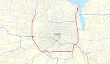
New York State Route 47 (NY 47) was a 19.34 miles (31.12 km) long state highway
around Rochester
in New York
, United States
. It formed a semicircle through the inner suburb
s of Rochester, following expressways west and east of the city and surface streets south of Rochester. The western terminus of the route was at an interchange with NY 104
west of the city limits in Greece
. The eastern terminus was at an intersection with Culver Road in Irondequoit
mere yards from Lake Ontario
. In between its western and eastern extents, NY 47 met Interstate 490
(I-490) twice. The limited-access highway portions of the route were known as the Rochester Outer Loop (or Outer Loop) in contrast to the Inner Loop
around downtown Rochester.
NY 47 was originally routed along surface streets through the city when it was assigned ca. 1937. It began at NY 31
in Gates
and followed Howard Road and Brooks Avenue southeast into Rochester, where it continued eastward on Genesee Park Boulevard and Elmwood Avenue. NY 47 remained on the latter through Brighton
to an area known as Twelve Corners. At this point, the route turned north onto Winton Road and followed that street through the eastern fringe of the city to Irondequoit, where NY 47 ended at a junction with U.S. Route 104 (US 104, now NY 404
). The Outer Loop was constructed in stages, beginning with the portion of the Sea Breeze Expressway north of Ridge Road
in the early 1950s. From that point on, construction progressed in a generally clockwise fashion around the city.
By the late 1960s and early 1970s, the Outer Loop was complete from NY 383
to US 104 west of the city and from modern I-590
exit 1 to the lakeshore east of Rochester. NY 47 followed the loop from US 104 south to NY 383 and from Elmwood Avenue north to modern NY 590
exit 8; north of that point, the expressway was part of US 104 and NY 18
. NY 47 was extended northward along the remainder of the Sea Breeze Expressway in 1970. On March 18, 1980, the NY 47 designation was removed and replaced with several others, primarily I-390
, I-590, NY 390
, and NY 590.
 NY 47 followed a half-circle routing around the city of Rochester
, beginning northwest of downtown in the town of Greece
and proceeding generally counterclockwise around the city before ending northeast of downtown at the Lake Ontario
shoreline in Irondequoit
. The limited-access highway portions of NY 47 were named the "Rochester Outer Loop" (or "Outer Loop") in contrast to the Inner Loop
around downtown Rochester. This moniker remains in use to this day, now referring to the designations that have since replaced NY 47 along the loop. Conceptually, NY 104
completes the Outer Loop along the north side of the city. However, only the section east of the Genesee River
is expressway, leaving NY 104 from modern NY 390
to the Veterans Memorial Bridge
as the only at-grade portion of the loop. The at-grade portion of NY 47 along Scottsville Road and Elmwood Avenue was known as the "Rochester Bypass" prior to the completion of the Outer Loop. The alignment described within this section is of NY 47 upon its removal in 1980.
, where NY 47 continued onto what is now I-390
. The routings of NY 47 and current I-390 were identical to NY 383
(Scottsville Road) in Chili
, where NY 47 was forced to grade level via a partially constructed interchange, as modern I-390 had yet to be constructed in the area southeast of NY 383.
 Off the expressway and now at-grade, NY 47 turned north onto NY 383, forming a short concurrency
with NY 383 into Rochester. At Elmwood Avenue, NY 47 and NY 383 departed Scottsville Road and proceeded eastward on Elmwood Avenue. Two blocks to the east, at an intersection with South Plymouth Avenue, NY 383 split from NY 47, following Plymouth Avenue into downtown Rochester. NY 47 remained routed on Elmwood Avenue, crossing the Genesee River
and passing north of Strong Memorial Hospital
prior to intersecting NY 15
(Mount Hope Avenue) in the shadow of Mount Hope Cemetery
. East of NY 15, NY 47 progressed along Elmwood Avenue, intersecting several local streets before entering Brighton
.
Within Brighton, NY 47 continued on Elmwood Avenue through "Twelve Corners", intersecting NY 31
(Monroe Avenue) at the location, to what is now I-590
. At the northbound entrance ramp of the modern interchange between I-590 and Elmwood Avenue, NY 47 separated from the latter, entering the freeway. While what is now I-590 was constructed and open from Winton Road to I-490, it had no signed designation between Winton and Elmwood.
through Brighton, Rochester, and Irondequoit to Culver Road at the Lake Ontario shoreline.
_map.png) When NY 47 was first commissioned in the Rochester
When NY 47 was first commissioned in the Rochester
area ca. 1937, it was routed along previously unnumbered roadways, with its northwest terminus located at the intersection of NY 31
(Lyell Avenue) and Howard Road in Gates
. NY 47 took Howard Road south, passing through Gates Center and intersecting NY 33
before crossing the then-New York Central Railroad
main line (now the CSX Transportation
-owned Rochester Subdivision
) at-grade. The route remained on Howard Road until the intersection of Howard Road and Chili Avenue (NY 33A
), which also included Brooks Avenue at this juncture of time. NY 47 turned east onto Brooks Avenue and proceeded toward the Greater Rochester International Airport
, joining the current routing of NY 204
at Beahan Road (now Old Beahan Road).
 NY 47 followed the entire alignment of NY 204 to what is now I-390
and continued on Brooks Avenue into Rochester to Genesee Park Boulevard. Route 47 turned south onto the street, which circles around the southwestern quadrant of the city, and followed its length to Genesee Street, where it turned south for a short distance before resuming its eastward alignment on Elmwood Avenue. The route remained on Elmwood Avenue into Brighton
, where it turned north onto South Winton Road at Twelve Corners. At Highland Avenue, NY 47 reentered Rochester and became North Winton Road at East Avenue (NY 96
). The route remained on Winton through Rochester and Irondequoit
before terminating at Empire Boulevard (then US 104, now NY 404
) just west of Irondequoit Bay
.
shoreline to the proposed I-490
east of Rochester. The first portion of the road, a divided highway
extending from East Ridge Road
in Irondequoit to Culver Road just west of the Irondequoit Bay Outlet, was opened to traffic by 1954 as a realignment of NY 18
. Construction on a limited-access extension south to Empire Boulevard (three blocks west of NY 47's western terminus) began at some point between 1956 and 1958 and was completed by 1960 as a realignment of US 104. Another extension of the highway south to the partially complete I-490 in Brighton was completed ca. 1961 and largely became part of a rerouted NY 47 by the following year. At the time, NY 47 left the expressway at Blossom Road and followed it west to Winton Road, where it rejoined its original routing.
 By 1964, construction was underway on a new expressway leading south from I-490 at the Can of Worms to Elmwood Avenue east of Twelve Corners. The highway was completed ca. 1965, at which time NY 47 was realigned to follow the Sea Breeze Expressway and the new expressway south through the Can of Worms to its end at a partial interchange with Elmwood Avenue (now I-590
exit 3). It continued west on Elmwood Avenue to Twelve Corners, where it reconnected to its old alignment at Winton Road.
), where it turned to overlap NY 383 north to Elmwood Avenue. At the time, Beahan Road connected directly to Scottsville Road (via modern Old Beahan Road) as the primary runway
southwest of the airport had yet to be extended to its present length. By 1962, construction was underway on a new limited-access highway paralleling NY 47 (Howard Road) to the east between NY 31 and NY 33. Within two years, work had begun on an extension of the highway south along the Erie Canal
to Scottsville Road. Farther east, construction was underway on a new highway leading south from I-490 to Elmwood Avenue east of Twelve Corners.
 All of the limited-access highway between NY 31 and NY 383 opened to traffic ca. 1965. NY 47 was reconfigured to begin a half-mile (0.8 km) to the east of Howard Road at modern NY 390
exit 21 and follow the new highway southeastward to its temporary end at what is now I-390
exit 17 east of the airport. At this point, NY 47 joined its pre-1965 routing and followed NY 383 northeastward into the city limits. By 1968, construction was underway on a northward extension of the expressway to US 104 in Greece
. It was completed and opened to traffic by 1971.
on opposite sides of Rochester. In Greece, the designation officially followed what is now NY 390 north to the Lake Ontario State Parkway
; however, the portion between US 104 and the parkway had yet to be constructed. To the east in Irondequoit, NY 47 was stretched northward along the Sea Breeze Expressway to Culver Road, resulting in overlaps
with both US 104 and NY 18. At the time, the overlap with US 104 existed only between Empire Boulevard and the Keeler Street Expressway, which became the new alignment of the route through Irondequoit after its completion in 1969. The overlap with US 104 was eliminated entirely the following year when that route was realigned onto a new expressway alignment between NY 47 and Webster
that traversed Irondequoit Bay
via the newly built Irondequoit Bay Bridge
. The overlap with NY 18 was eliminated ca. 1973 when NY 18 was truncated to its current eastern terminus in Kodak Park
.
On March 18, 1980, the NY 47 designation was eliminated and split into four other routes. From NY 104 in Greece to I-490, NY 47 became NY 390. The section from I-490 south to NY 383 was designated as part of I-390; however, it would not connect to the existing portion of I-390 south of Rochester until 1981, when the interchange between I-390 and I-590 was completed. The segment of NY 47 from Elmwood Avenue north to the Can of Worms became part of I-590, which continued southwest along the freeway to Winton Road. From the Can of Worms to Lake Ontario, NY 47 was redesignated NY 590
.
Off the expressways, the former alignments of NY 47 now carry several designations. Howard Road, bypassed by the 1960s realignment in Gates, is still maintained by the New York State Department of Transportation
as NY 940L, an unsigned reference route 2.37 miles (3.81 km) in length. Beahan Road, also bypassed by the same 1960s rerouting, was reconfigured into its current alignment by 1971 due to an expansion by the airport. All of Beahan Road, including the portion north of the grade crossing with the Rochester and Southern Railroad
that carried NY 47, is currently maintained by Monroe County
as County Route 164 (CR 164). The portion of NY 47 on Elmwood Avenue from the Rochester city line to I-590, as well as the remainder of Elmwood Avenue east to NY 96
, is also maintained by Monroe County as CR 87. Lastly, the segments of Winton Road outside of the Rochester city limits are now CR 98, a designation that extends south past Twelve Corners to the southern end of Winton Road in Henrietta
. The remainder of circa-1980 NY 47 and the former alignments of the route are currently locally maintained.
State highway
State highway, state road or state route can refer to one of three related concepts, two of them related to a state or provincial government in a country that is divided into states or provinces :#A...
around Rochester
Rochester, New York
Rochester is a city in Monroe County, New York, south of Lake Ontario in the United States. Known as The World's Image Centre, it was also once known as The Flour City, and more recently as The Flower City...
in New York
New York
New York is a state in the Northeastern region of the United States. It is the nation's third most populous state. New York is bordered by New Jersey and Pennsylvania to the south, and by Connecticut, Massachusetts and Vermont to the east...
, United States
United States
The United States of America is a federal constitutional republic comprising fifty states and a federal district...
. It formed a semicircle through the inner suburb
Suburb
The word suburb mostly refers to a residential area, either existing as part of a city or as a separate residential community within commuting distance of a city . Some suburbs have a degree of administrative autonomy, and most have lower population density than inner city neighborhoods...
s of Rochester, following expressways west and east of the city and surface streets south of Rochester. The western terminus of the route was at an interchange with NY 104
New York State Route 104
New York State Route 104 is a long east–west state highway in Upstate New York, United States. It spans six counties and enters the vicinity of four cities—Niagara Falls, Lockport, Rochester, and Oswego—as it follows a routing largely parallel to that of the southern shoreline of Lake...
west of the city limits in Greece
Greece (town), New York
Greece is a town in Monroe County, New York, United States. As of the 2010 United States census, the town had a total population of 96,095. The town motto is "Discover the Promise."...
. The eastern terminus was at an intersection with Culver Road in Irondequoit
Irondequoit, New York
Irondequoit is a town in Monroe County, New York, USA. As of the 2010 census, the coterminous town-CDP had a total population of 51,692...
mere yards from Lake Ontario
Lake Ontario
Lake Ontario is one of the five Great Lakes of North America. It is bounded on the north and southwest by the Canadian province of Ontario, and on the south by the American state of New York. Ontario, Canada's most populous province, was named for the lake. In the Wyandot language, ontarío means...
. In between its western and eastern extents, NY 47 met Interstate 490
Interstate 490 (New York)
Interstate 490 is an auxiliary Interstate Highway that serves the city of Rochester, New York, in the United States. It acts as a northerly alternate route to the New York State Thruway , leaving it at exit 47 in the town of Le Roy and rejoining the highway at exit 45 in the town of...
(I-490) twice. The limited-access highway portions of the route were known as the Rochester Outer Loop (or Outer Loop) in contrast to the Inner Loop
Inner Loop (Rochester)
The Inner Loop is an expressway that encloses downtown Rochester, New York, in the United States. Although the expressway is a continuous loop, only the portion of the loop north of Interstate 490 is signed as the "Inner Loop"...
around downtown Rochester.
NY 47 was originally routed along surface streets through the city when it was assigned ca. 1937. It began at NY 31
New York State Route 31
New York State Route 31 is a state highway that extends for across western and central New York in the United States. The western terminus of the route is at an intersection with NY 104 in the city of Niagara Falls. Its eastern terminus is at a traffic circle with NY 26 in Vernon...
in Gates
Gates, New York
Gates is a town in Monroe County, New York. The town is named after General Horatio Gates. The population was 28,400 at the 2010 census. Gates-North Gates census-designated place is located within the town's boundaries....
and followed Howard Road and Brooks Avenue southeast into Rochester, where it continued eastward on Genesee Park Boulevard and Elmwood Avenue. NY 47 remained on the latter through Brighton
Brighton, Monroe County, New York
Brighton is a town in Monroe County, New York, USA. The population was 36,609 at the 2010 census.-History:The Town of Brighton, located on the southeast border of the city of Rochester, was originally settled approximately 1790, and formally established in 1814—earning it recognition as one...
to an area known as Twelve Corners. At this point, the route turned north onto Winton Road and followed that street through the eastern fringe of the city to Irondequoit, where NY 47 ended at a junction with U.S. Route 104 (US 104, now NY 404
New York State Route 404
New York State Route 404 is an east–west state highway located in eastern Monroe County, New York, in the United States. It extends for just over from an interchange with NY 590 in Irondequoit to an intersection with NY 104 on the Monroe–Wayne County line in the town of Webster...
). The Outer Loop was constructed in stages, beginning with the portion of the Sea Breeze Expressway north of Ridge Road
Ridge Road (Western New York)
Ridge Road is a east–west road that traverses four counties in Upstate New York in the United States. It is named for the rise atop which the road was built, a mound of sand and gravel that was formed when it was the shoreline of ancient Glacial Lake Iroquois...
in the early 1950s. From that point on, construction progressed in a generally clockwise fashion around the city.
By the late 1960s and early 1970s, the Outer Loop was complete from NY 383
New York State Route 383
New York State Route 383 is an north–south state highway in Monroe County, New York, in the United States. The southern terminus of the route is at an intersection with NY 36 in the hamlet of Mumford within the town of Wheatland. Its northern terminus is at a junction with NY 31 in...
to US 104 west of the city and from modern I-590
Interstate 590
Interstate 590 is a north–south auxiliary Interstate Highway that serves the immediate southeastern suburbs of the city of Rochester, New York, in the United States. It extends for from an interchange with I-390 in Brighton to the Can of Worms, a complex interchange connecting I-590 to I-490...
exit 1 to the lakeshore east of Rochester. NY 47 followed the loop from US 104 south to NY 383 and from Elmwood Avenue north to modern NY 590
New York State Route 590
New York State Route 590 is a north–south state highway located in the eastern suburbs of Rochester, New York, in the United States...
exit 8; north of that point, the expressway was part of US 104 and NY 18
New York State Route 18
New York State Route 18 is an east–west state highway in western New York in the United States. It runs parallel to the south shore of Lake Ontario for most of its length between Niagara County and Monroe County...
. NY 47 was extended northward along the remainder of the Sea Breeze Expressway in 1970. On March 18, 1980, the NY 47 designation was removed and replaced with several others, primarily I-390
Interstate 390
Interstate 390 is a north–south auxiliary Interstate Highway located entirely within New York in the United States. The southern terminus of the route is at the Southern Tier Expressway in the town of Avoca. Its northern terminus is at I-490 in Rochester...
, I-590, NY 390
New York State Route 390
New York State Route 390 is a north–south state highway located along the western edge of the city of Rochester, New York, in the United States. The route, a limited-access northward continuation of Interstate 390 , extends for from I-490 in Gates to the Lake Ontario State Parkway in...
, and NY 590.
Route description
Rochester, New York
Rochester is a city in Monroe County, New York, south of Lake Ontario in the United States. Known as The World's Image Centre, it was also once known as The Flour City, and more recently as The Flower City...
, beginning northwest of downtown in the town of Greece
Greece (town), New York
Greece is a town in Monroe County, New York, United States. As of the 2010 United States census, the town had a total population of 96,095. The town motto is "Discover the Promise."...
and proceeding generally counterclockwise around the city before ending northeast of downtown at the Lake Ontario
Lake Ontario
Lake Ontario is one of the five Great Lakes of North America. It is bounded on the north and southwest by the Canadian province of Ontario, and on the south by the American state of New York. Ontario, Canada's most populous province, was named for the lake. In the Wyandot language, ontarío means...
shoreline in Irondequoit
Irondequoit, New York
Irondequoit is a town in Monroe County, New York, USA. As of the 2010 census, the coterminous town-CDP had a total population of 51,692...
. The limited-access highway portions of NY 47 were named the "Rochester Outer Loop" (or "Outer Loop") in contrast to the Inner Loop
Inner Loop (Rochester)
The Inner Loop is an expressway that encloses downtown Rochester, New York, in the United States. Although the expressway is a continuous loop, only the portion of the loop north of Interstate 490 is signed as the "Inner Loop"...
around downtown Rochester. This moniker remains in use to this day, now referring to the designations that have since replaced NY 47 along the loop. Conceptually, NY 104
New York State Route 104
New York State Route 104 is a long east–west state highway in Upstate New York, United States. It spans six counties and enters the vicinity of four cities—Niagara Falls, Lockport, Rochester, and Oswego—as it follows a routing largely parallel to that of the southern shoreline of Lake...
completes the Outer Loop along the north side of the city. However, only the section east of the Genesee River
Genesee River
The Genesee River is a North American river flowing northward through the Twin Tiers of Pennsylvania and New York. The river provided the original power for the Rochester area's 19th century mills and still provides hydroelectric power for downtown Rochester....
is expressway, leaving NY 104 from modern NY 390
New York State Route 390
New York State Route 390 is a north–south state highway located along the western edge of the city of Rochester, New York, in the United States. The route, a limited-access northward continuation of Interstate 390 , extends for from I-490 in Gates to the Lake Ontario State Parkway in...
to the Veterans Memorial Bridge
Veterans Memorial Bridge (Rochester, New York)
The Veterans Memorial Bridge in Rochester, New York, carries NY Route 104 across the Genesee River. The bridge is an architecturally significant concrete arch faced with white granite. Conceived in 1928 and finished in 1931, the span is the longest bridge in Rochester at 981 feet...
as the only at-grade portion of the loop. The at-grade portion of NY 47 along Scottsville Road and Elmwood Avenue was known as the "Rochester Bypass" prior to the completion of the Outer Loop. The alignment described within this section is of NY 47 upon its removal in 1980.
Western expressway
NY 47 began at an interchange with NY 104 (now the interchange between NY 390 and NY 104) in Greece one mile (1.6 km) west of the Rochester city limits. Although, at the time, the freeway terminated just north of the interchange, the interchange itself was roughly complete, with only ramps to and from future NY 390 north of the interchange missing. NY 47 followed the modern NY 390 alignment south to I-490Interstate 490 (New York)
Interstate 490 is an auxiliary Interstate Highway that serves the city of Rochester, New York, in the United States. It acts as a northerly alternate route to the New York State Thruway , leaving it at exit 47 in the town of Le Roy and rejoining the highway at exit 45 in the town of...
, where NY 47 continued onto what is now I-390
Interstate 390
Interstate 390 is a north–south auxiliary Interstate Highway located entirely within New York in the United States. The southern terminus of the route is at the Southern Tier Expressway in the town of Avoca. Its northern terminus is at I-490 in Rochester...
. The routings of NY 47 and current I-390 were identical to NY 383
New York State Route 383
New York State Route 383 is an north–south state highway in Monroe County, New York, in the United States. The southern terminus of the route is at an intersection with NY 36 in the hamlet of Mumford within the town of Wheatland. Its northern terminus is at a junction with NY 31 in...
(Scottsville Road) in Chili
Chili, New York
Chili is a town in Monroe County, New York, USA. The population was 28,625 at the 2010 census. It is a suburb of the city of Rochester.The Town of Chili was established in 1822 from part of the Town of Riga....
, where NY 47 was forced to grade level via a partially constructed interchange, as modern I-390 had yet to be constructed in the area southeast of NY 383.
At-grade
Concurrency (road)
A concurrency, overlap, or coincidence in a road network is an instance of one physical road bearing two or more different highway, motorway, or other route numbers...
with NY 383 into Rochester. At Elmwood Avenue, NY 47 and NY 383 departed Scottsville Road and proceeded eastward on Elmwood Avenue. Two blocks to the east, at an intersection with South Plymouth Avenue, NY 383 split from NY 47, following Plymouth Avenue into downtown Rochester. NY 47 remained routed on Elmwood Avenue, crossing the Genesee River
Genesee River
The Genesee River is a North American river flowing northward through the Twin Tiers of Pennsylvania and New York. The river provided the original power for the Rochester area's 19th century mills and still provides hydroelectric power for downtown Rochester....
and passing north of Strong Memorial Hospital
Strong Memorial Hospital
Strong Memorial Hospital is a 739-bed medical facility, part of the University of Rochester Medical Center complex , in Rochester, New York. Opened in 1926, is a major provider of both in-patient and out-patient medical services....
prior to intersecting NY 15
New York State Route 15
New York State Route 15 is a north–south state highway located in western New York in the United States. The southern terminus of the route is officially at Interstate 390 exit 3 south of the village of Wayland, although some signage indicating that NY 15 continues south to...
(Mount Hope Avenue) in the shadow of Mount Hope Cemetery
Mount Hope Cemetery, Rochester
Mount Hope Cemetery in Rochester, New York, founded in 1838, is the United States' first municipal rural cemetery. Situated on 196 acres of land adjacent to the University of Rochester on Mount Hope Avenue, the cemetery is the permanent resting place of over 350,000 people...
. East of NY 15, NY 47 progressed along Elmwood Avenue, intersecting several local streets before entering Brighton
Brighton, Monroe County, New York
Brighton is a town in Monroe County, New York, USA. The population was 36,609 at the 2010 census.-History:The Town of Brighton, located on the southeast border of the city of Rochester, was originally settled approximately 1790, and formally established in 1814—earning it recognition as one...
.
Within Brighton, NY 47 continued on Elmwood Avenue through "Twelve Corners", intersecting NY 31
New York State Route 31
New York State Route 31 is a state highway that extends for across western and central New York in the United States. The western terminus of the route is at an intersection with NY 104 in the city of Niagara Falls. Its eastern terminus is at a traffic circle with NY 26 in Vernon...
(Monroe Avenue) at the location, to what is now I-590
Interstate 590
Interstate 590 is a north–south auxiliary Interstate Highway that serves the immediate southeastern suburbs of the city of Rochester, New York, in the United States. It extends for from an interchange with I-390 in Brighton to the Can of Worms, a complex interchange connecting I-590 to I-490...
. At the northbound entrance ramp of the modern interchange between I-590 and Elmwood Avenue, NY 47 separated from the latter, entering the freeway. While what is now I-590 was constructed and open from Winton Road to I-490, it had no signed designation between Winton and Elmwood.
Eastern expressway
NY 47 followed modern I-590 northward through Brighton to the Can of Worms, where NY 47 met I-490 for the second time. Due to the way the interchange was designed at the time, traffic continuing on NY 47 across I-490 had to merge with I-490 traffic for roughly 1000 feet (305 m) before exiting I-490 onto the other portion of NY 47. North of I-490, NY 47 followed the length of what is now NY 590New York State Route 590
New York State Route 590 is a north–south state highway located in the eastern suburbs of Rochester, New York, in the United States...
through Brighton, Rochester, and Irondequoit to Culver Road at the Lake Ontario shoreline.
Original alignment
Rochester, New York
Rochester is a city in Monroe County, New York, south of Lake Ontario in the United States. Known as The World's Image Centre, it was also once known as The Flour City, and more recently as The Flower City...
area ca. 1937, it was routed along previously unnumbered roadways, with its northwest terminus located at the intersection of NY 31
New York State Route 31
New York State Route 31 is a state highway that extends for across western and central New York in the United States. The western terminus of the route is at an intersection with NY 104 in the city of Niagara Falls. Its eastern terminus is at a traffic circle with NY 26 in Vernon...
(Lyell Avenue) and Howard Road in Gates
Gates, New York
Gates is a town in Monroe County, New York. The town is named after General Horatio Gates. The population was 28,400 at the 2010 census. Gates-North Gates census-designated place is located within the town's boundaries....
. NY 47 took Howard Road south, passing through Gates Center and intersecting NY 33
New York State Route 33
New York State Route 33 is an east–west state highway in western New York in the United States. The route extends for just under from NY 5 in Buffalo in the west to NY 31 in Rochester in the east. It is, in fact, the only state highway that directly connects both cities, although...
before crossing the then-New York Central Railroad
New York Central Railroad
The New York Central Railroad , known simply as the New York Central in its publicity, was a railroad operating in the Northeastern United States...
main line (now the CSX Transportation
CSX Transportation
CSX Transportation operates a Class I railroad in the United States known as the CSX Railroad. It is the main subsidiary of the CSX Corporation. The company is headquartered in Jacksonville, Florida, and owns approximately 21,000 route miles...
-owned Rochester Subdivision
Rochester Subdivision
The Rochester Subdivision is a railroad line owned by CSX Transportation in the U.S. state of New York. The line runs from Syracuse west to Buffalo along the former New York Central Railroad main line. At its east end, west of downtown Syracuse, the line becomes the Mohawk Subdivision...
) at-grade. The route remained on Howard Road until the intersection of Howard Road and Chili Avenue (NY 33A
New York State Route 33A
New York State Route 33A is an east–west state highway mostly located in Monroe County, New York, in the United States. The route is just over long and serves as an alternate route of NY 33 between the town of Bergen in Genesee County and the city of Rochester in Monroe County...
), which also included Brooks Avenue at this juncture of time. NY 47 turned east onto Brooks Avenue and proceeded toward the Greater Rochester International Airport
Greater Rochester International Airport
Greater Rochester International Airport is a county-owned public-use airport located three nautical miles southwest of the central business district of Rochester, a city in Monroe County, New York, United States...
, joining the current routing of NY 204
New York State Route 204
New York State Route 204 is an east–west state highway located just southeast of Rochester in Monroe County, New York, in the United States. The western terminus of the route is at exit 6 on Interstate 490 in Gates. Its eastern terminus is at the Rochester city line just east of...
at Beahan Road (now Old Beahan Road).
Interstate 390
Interstate 390 is a north–south auxiliary Interstate Highway located entirely within New York in the United States. The southern terminus of the route is at the Southern Tier Expressway in the town of Avoca. Its northern terminus is at I-490 in Rochester...
and continued on Brooks Avenue into Rochester to Genesee Park Boulevard. Route 47 turned south onto the street, which circles around the southwestern quadrant of the city, and followed its length to Genesee Street, where it turned south for a short distance before resuming its eastward alignment on Elmwood Avenue. The route remained on Elmwood Avenue into Brighton
Brighton, Monroe County, New York
Brighton is a town in Monroe County, New York, USA. The population was 36,609 at the 2010 census.-History:The Town of Brighton, located on the southeast border of the city of Rochester, was originally settled approximately 1790, and formally established in 1814—earning it recognition as one...
, where it turned north onto South Winton Road at Twelve Corners. At Highland Avenue, NY 47 reentered Rochester and became North Winton Road at East Avenue (NY 96
New York State Route 96
New York State Route 96 is a northwest–southeast state highway in the Finger Lakes region of New York in the United States. The southern terminus of the route is at an interchange with NY 17 in the Southern Tier village of Owego, Tioga County. Its northern terminus is at a junction with...
). The route remained on Winton through Rochester and Irondequoit
Irondequoit, New York
Irondequoit is a town in Monroe County, New York, USA. As of the 2010 census, the coterminous town-CDP had a total population of 51,692...
before terminating at Empire Boulevard (then US 104, now NY 404
New York State Route 404
New York State Route 404 is an east–west state highway located in eastern Monroe County, New York, in the United States. It extends for just over from an interchange with NY 590 in Irondequoit to an intersection with NY 104 on the Monroe–Wayne County line in the town of Webster...
) just west of Irondequoit Bay
Irondequoit Bay
Irondequoit Bay is a large body of water located in northeastern Monroe County, New York. The bay, roughly wide and in length, is fed by Irondequoit Creek to the south and flows into Lake Ontario at its northern end...
.
East of Rochester
In the early 1950s, construction began on the Sea Breeze Expressway, a mostly limited-access highway linking the Lake OntarioLake Ontario
Lake Ontario is one of the five Great Lakes of North America. It is bounded on the north and southwest by the Canadian province of Ontario, and on the south by the American state of New York. Ontario, Canada's most populous province, was named for the lake. In the Wyandot language, ontarío means...
shoreline to the proposed I-490
Interstate 490 (New York)
Interstate 490 is an auxiliary Interstate Highway that serves the city of Rochester, New York, in the United States. It acts as a northerly alternate route to the New York State Thruway , leaving it at exit 47 in the town of Le Roy and rejoining the highway at exit 45 in the town of...
east of Rochester. The first portion of the road, a divided highway
Divided Highway
Divided Highway is a compilation album by American rock band The Doobie Brothers, released in 2003. . All tracks are taken from the albums Cycles and Brotherhood .-Track listing:...
extending from East Ridge Road
Ridge Road (Western New York)
Ridge Road is a east–west road that traverses four counties in Upstate New York in the United States. It is named for the rise atop which the road was built, a mound of sand and gravel that was formed when it was the shoreline of ancient Glacial Lake Iroquois...
in Irondequoit to Culver Road just west of the Irondequoit Bay Outlet, was opened to traffic by 1954 as a realignment of NY 18
New York State Route 18
New York State Route 18 is an east–west state highway in western New York in the United States. It runs parallel to the south shore of Lake Ontario for most of its length between Niagara County and Monroe County...
. Construction on a limited-access extension south to Empire Boulevard (three blocks west of NY 47's western terminus) began at some point between 1956 and 1958 and was completed by 1960 as a realignment of US 104. Another extension of the highway south to the partially complete I-490 in Brighton was completed ca. 1961 and largely became part of a rerouted NY 47 by the following year. At the time, NY 47 left the expressway at Blossom Road and followed it west to Winton Road, where it rejoined its original routing.
Interstate 590
Interstate 590 is a north–south auxiliary Interstate Highway that serves the immediate southeastern suburbs of the city of Rochester, New York, in the United States. It extends for from an interchange with I-390 in Brighton to the Can of Worms, a complex interchange connecting I-590 to I-490...
exit 3). It continued west on Elmwood Avenue to Twelve Corners, where it reconnected to its old alignment at Winton Road.
West of Rochester
The first realignment of NY 47 west of the city occurred ca. 1962 when it was rerouted between Chili and Elmwood Avenues to bypass the then-Rochester – Monroe County Airport to the south. Instead of turning east onto Brooks Avenue as it did prior to 1962, the route continued south on Beahan Road to Scottsville Road (NY 383New York State Route 383
New York State Route 383 is an north–south state highway in Monroe County, New York, in the United States. The southern terminus of the route is at an intersection with NY 36 in the hamlet of Mumford within the town of Wheatland. Its northern terminus is at a junction with NY 31 in...
), where it turned to overlap NY 383 north to Elmwood Avenue. At the time, Beahan Road connected directly to Scottsville Road (via modern Old Beahan Road) as the primary runway
Runway
According to ICAO a runway is a "defined rectangular area on a land aerodrome prepared for the landing and take-off of aircraft." Runways may be a man-made surface or a natural surface .- Orientation and dimensions :Runways are named by a number between 01 and 36, which is generally one tenth...
southwest of the airport had yet to be extended to its present length. By 1962, construction was underway on a new limited-access highway paralleling NY 47 (Howard Road) to the east between NY 31 and NY 33. Within two years, work had begun on an extension of the highway south along the Erie Canal
Erie Canal
The Erie Canal is a waterway in New York that runs about from Albany, New York, on the Hudson River to Buffalo, New York, at Lake Erie, completing a navigable water route from the Atlantic Ocean to the Great Lakes. The canal contains 36 locks and encompasses a total elevation differential of...
to Scottsville Road. Farther east, construction was underway on a new highway leading south from I-490 to Elmwood Avenue east of Twelve Corners.
New York State Route 390
New York State Route 390 is a north–south state highway located along the western edge of the city of Rochester, New York, in the United States. The route, a limited-access northward continuation of Interstate 390 , extends for from I-490 in Gates to the Lake Ontario State Parkway in...
exit 21 and follow the new highway southeastward to its temporary end at what is now I-390
Interstate 390
Interstate 390 is a north–south auxiliary Interstate Highway located entirely within New York in the United States. The southern terminus of the route is at the Southern Tier Expressway in the town of Avoca. Its northern terminus is at I-490 in Rochester...
exit 17 east of the airport. At this point, NY 47 joined its pre-1965 routing and followed NY 383 northeastward into the city limits. By 1968, construction was underway on a northward extension of the expressway to US 104 in Greece
Greece (town), New York
Greece is a town in Monroe County, New York, United States. As of the 2010 United States census, the town had a total population of 96,095. The town motto is "Discover the Promise."...
. It was completed and opened to traffic by 1971.
Extensions and deletion
NY 47 was officially extended on both ends on January 1, 1970, to terminate at Lake OntarioLake Ontario
Lake Ontario is one of the five Great Lakes of North America. It is bounded on the north and southwest by the Canadian province of Ontario, and on the south by the American state of New York. Ontario, Canada's most populous province, was named for the lake. In the Wyandot language, ontarío means...
on opposite sides of Rochester. In Greece, the designation officially followed what is now NY 390 north to the Lake Ontario State Parkway
Lake Ontario State Parkway
The Lake Ontario State Parkway is a parkway along the southern shore of Lake Ontario in western New York in the United States. The western end of the highway is at a partial interchange within Lakeside Beach State Park in Carlton, Orleans County. Its eastern terminus is at an intersection with...
; however, the portion between US 104 and the parkway had yet to be constructed. To the east in Irondequoit, NY 47 was stretched northward along the Sea Breeze Expressway to Culver Road, resulting in overlaps
Concurrency (road)
A concurrency, overlap, or coincidence in a road network is an instance of one physical road bearing two or more different highway, motorway, or other route numbers...
with both US 104 and NY 18. At the time, the overlap with US 104 existed only between Empire Boulevard and the Keeler Street Expressway, which became the new alignment of the route through Irondequoit after its completion in 1969. The overlap with US 104 was eliminated entirely the following year when that route was realigned onto a new expressway alignment between NY 47 and Webster
Webster (town), New York
Webster is a town in the northeast corner of Monroe County, New York, United States. The town is named after orator and statesman Daniel Webster. The population was 42,641 at the 2010 census....
that traversed Irondequoit Bay
Irondequoit Bay
Irondequoit Bay is a large body of water located in northeastern Monroe County, New York. The bay, roughly wide and in length, is fed by Irondequoit Creek to the south and flows into Lake Ontario at its northern end...
via the newly built Irondequoit Bay Bridge
Irondequoit Bay Bridge
Irondequoit Bay Bridge is located near Rochester, New York and carries Route 104 across the Irondequoit Bay between Irondequoit and Webster near the intersection with Rt 590. According to the National Bridge Inventory the bridge was built in 1967. Its total span is with nine spans and an...
. The overlap with NY 18 was eliminated ca. 1973 when NY 18 was truncated to its current eastern terminus in Kodak Park
Kodak Park
Eastman Business Park, formerly Kodak Park, is a large manufacturing and industrial complex in the city of Rochester, New York, in the United States. The complex is run by Eastman Kodak and is located north of downtown Rochester and south of Lake Ontario...
.
On March 18, 1980, the NY 47 designation was eliminated and split into four other routes. From NY 104 in Greece to I-490, NY 47 became NY 390. The section from I-490 south to NY 383 was designated as part of I-390; however, it would not connect to the existing portion of I-390 south of Rochester until 1981, when the interchange between I-390 and I-590 was completed. The segment of NY 47 from Elmwood Avenue north to the Can of Worms became part of I-590, which continued southwest along the freeway to Winton Road. From the Can of Worms to Lake Ontario, NY 47 was redesignated NY 590
New York State Route 590
New York State Route 590 is a north–south state highway located in the eastern suburbs of Rochester, New York, in the United States...
.
Off the expressways, the former alignments of NY 47 now carry several designations. Howard Road, bypassed by the 1960s realignment in Gates, is still maintained by the New York State Department of Transportation
New York State Department of Transportation
The New York State Department of Transportation is responsible for the development and operation of highways, railroads, mass transit systems, ports, waterways and aviation facilities in the U.S...
as NY 940L, an unsigned reference route 2.37 miles (3.81 km) in length. Beahan Road, also bypassed by the same 1960s rerouting, was reconfigured into its current alignment by 1971 due to an expansion by the airport. All of Beahan Road, including the portion north of the grade crossing with the Rochester and Southern Railroad
Rochester and Southern Railroad
The Rochester and Southern Railroad , a subsidiary of Genesee & Wyoming Inc., is a class III shortline that runs from the city of Rochester in Monroe County to Silver Springs, NY. The RSR started in 1986, when the B&O sold off its Buffalo and Rochester branches...
that carried NY 47, is currently maintained by Monroe County
Monroe County, New York
Monroe County is a county located in the U.S. state of New York. As of the 2010 census, the population was 744,344. It is named after James Monroe, fifth President of the United States of America. Its county seat is the city of Rochester....
as County Route 164 (CR 164). The portion of NY 47 on Elmwood Avenue from the Rochester city line to I-590, as well as the remainder of Elmwood Avenue east to NY 96
New York State Route 96
New York State Route 96 is a northwest–southeast state highway in the Finger Lakes region of New York in the United States. The southern terminus of the route is at an interchange with NY 17 in the Southern Tier village of Owego, Tioga County. Its northern terminus is at a junction with...
, is also maintained by Monroe County as CR 87. Lastly, the segments of Winton Road outside of the Rochester city limits are now CR 98, a designation that extends south past Twelve Corners to the southern end of Winton Road in Henrietta
Henrietta, New York
Henrietta is a town in Monroe County, New York, United States. It is a suburb of Rochester. The population was 42,581 at the 2010 census. Established in 1818, the town is named after Henrietta Laura Pulteney, Countess of Bath, daughter of Sir William Pulteney, 5th Baronet, a major British...
. The remainder of circa-1980 NY 47 and the former alignments of the route are currently locally maintained.