

Mackenzie Large Igneous Province
Encyclopedia
The Mackenzie Large Igneous Province (MLIP) is a major Mesoproterozoic
large igneous province
of the southwestern, western and northwestern Canadian Shield
in Canada
. It consists of a group of related igneous rock
s that were formed during a massive igneous event starting about 1,270 million years ago. The large igneous province extends from the Arctic
in Nunavut
to near the Great Lakes
in Northwestern Ontario
where it meets with the smaller Matachewan dike swarm
. Included in the Mackenzie Large Igneous Province are the large Muskox layered intrusion
, the Coppermine River flood basalt sequence and the massive northwesterly trending Mackenzie dike swarm
.
As a large igneous province, it is an extremely large area of related igneous rocks that were emplaced over an extremely short geological time span. The igneous rocks comprising the Mackenzie Large Igneous Province originated from processes not associated with normal plate tectonics
and seafloor spreading
. It is one of the several large igneous provinces scattered throughout the Canadian landscape, which can be thousands of kilometres in volume and area. The Mackenzie Large Igneous Province is also one of the largest Proterozoic
magma
tic provinces on Earth, as well as the world's largest and best-preserved continental flood basalt terrain. Igneous rocks of the Mackenzie Large Igneous Province are generally mafic
in composition, including basalt
and gabbro
.
Even though the Mackenzie Large Igneous Province is classified as a large igneous province like other extremely large accumulations of igneous rocks on Earth, it is much larger than large igneous province standards. The standard size classification for large igneous provinces is a minimum areal extent of 100000 square kilometre. However, the Mackenzie dike swarm itself occupies an area of at least 2700000 square kilometre, making the Mackenzie Large Igneous Province larger than the Ontong Java Plateau
in the southwestern Pacific Ocean
and the U.S. state
of Alaska
.
—an upwelling zone of abnormally hot rock within the Earth's mantle
. As the head of the Mackenzie plume encountered the Earth's lithosphere
, it spread out and melted catastrophically to form large volumes of basaltic magma. This resulted in the creation of a stationary volcanic zone west of Victoria Island that experienced considerable volcanism known as the Mackenzie hotspot
. Evidence for the Mackenzie hotspot include the existence of the giant mafic Mackenzie dike swarm because of its fanning pattern adjacent to the Muskox intrusion.
The size of the Mackenzie hotspot is considered to have been about 1000 kilometres (621.4 mi) in diameter. This calculation is based on the analysis of magmatic fabric in the Mackenzie dike swarm, which shows that magma flow was only vertical close to the middle of the Mackenzie plume and only subhorizontal away from the plume. However, if subhorizontal flow is a result of dike ascent to a level of impartial lightness in the Earth's crust, it would not be related to the size of the Mackenzie plume. Instead, the analysis of dike swarm geometry could possibly maintain evidence for the smallest diameter of the Mackenzie plume. The outer limit separating the zone of fanning dike geometry and subparallel dikes might be suggestive of the smallest diameter for the Mackenzie plume because it is not probable that the stress related to a magmatic zone has consequence over a region that is lesser than the Mackenzie plume, which created the feature. From this analysis, the smallest diameter of the Mackenzie plume would have been about 2000 km (1,242.7 mi). Uranium-lead dating
of certain Mackenzie dikes from an array of distances from an assigned focal point give an age of million years. This indicates that the Mackenzie hotspot essentially emplaced the Mackenzie Large Igneous Province as a whole throughout the associated landscape. The associated Mackenzie plume is consistent with mantle plumes that have deep origins within the Earth's mantle.
The Mackenzie hotspot is interpreted to have been similar to the early volcanism of the Yellowstone hotspot
. Both hotspots produced massive qualities of basaltic lava flows that were identical with the formation of dike swarms during a short period of time at the beginning of mantle plume volcanism. It is estimated that the majority of volcanism that formed the Mackenzie Large Igneous Province took place no more than two million years, and subsequent volcanism is unknown. However, the younger and smaller Franklin Large Igneous Province
just to the northeast is considered to have been formed by a similar mantle plume between 727 and 721 million years ago. The short time span of two million years for magma emplacement in the Mackenzie Large Igneous Province is also present for the Yellowstone hotspot.
, the geometry of which would have been partly controlled by dike swarm geometry. Fahrig (1987) proposed that the Mackenzie plume impact resulted in the emplacement of a triple junction
that had a large mafic dike swarm on every rift arm. Two of the first arms formed the Poseidon Ocean basin and the third arm failed thus forming an aulacogen
. This tectonic setting suggestion can be comparable with the early volcano-tectonic evolution of the Yellowstone hotspot, which developed two arms instead of three, followed by failure of both arms. At the Mackenzie hotspot, rifting is considered to have been passive and to have taken place in the crust above the hotspot that should have been weakened by the Mackenzie plume. Crustal uplift may have also provided stresses contributing to rifting.
A slightly younger but possibly related geologic feature is the 2000 km (1,242.7 mi) long Midcontinent Rift System
adjacent to the southern end of the Mackenzie Large Igneous Province. The Lake Superior
portion of the Midcontinent Rift System is bounded on the south by pre-existing continental faults that had substantial right-lateral movement before the formation of the Midcontinent Rift System. This period of rifting was a large event for copper
mineralization
, and the rifting event later deceased when the Grenville orogeny
collision occurred.
s, layered intrusions, sills
and dikes
, which are widespread throughout the large igneous province. With an area of 2700000 square kilometre, the Mackenzie event is the largest magmatic event ever to occur on the Canadian landscape. At least two magmatic formations can be considered large igneous provinces in their own advantage, both of which cover an area of more than 150000 square kilometre.
lies the massive Muskox intrusion. It remains as one of the largest and most studied layered intrusions on Earth, as well as one of the most valuable from an economic perspective. The intrusion represents the oldest igneous formation of the Mackenzie magmatic event, having formed between 1,905 and 1,155 million years ago. It maintains a triangular trough-shaped magma chamber
that extends 1.8 km (1.1 mi) below the surface. With a width of 20 km (12.4 mi) and a length of over 470 km (292 mi), the Muskox intrusion is overlain by a sequence of Coppermine flood basalts that remains 3 km (1.9 mi) thick.
The Muskox intrusion can be separated into three sections, including an olivine gabbro feeder dike to the intrusion, another contact margin zone, and an upper layered series. Because of different levels of erosion and outcroppings of the Muskox intrusion at higher structural levels, north of the Coppermine River
the overlying margin zone and layered series covers the feeder dike section. The layering series dips gently north as do the overlying Coppermine flood basalts. Weathering of the Muskox dipping sequence has exposed a cross-section through the entire dipping sequence, starting with the Coppermine flood basalts in the north above the roof of the magma chamber, down through the igneous layering of the Muskox intrusion and into the keel region of the intrusion and its intersection with the olivine gabbro feeder dike that forms the southernmost sector. The margin zone characterizes the western and eastern outer limits of the intrusion.
and northern Saskatchewan
to Nunavut and the Northwest Territories
. The Mackenzie dike swarm was emplaced into older metamorphic and igneous rocks of the Canadian Shield about 1,200 million years ago. Individual dikes of the Mackenzie swarm are respectively 1500 km (932.1 mi) to 2000 km (1,242.7 mi) long and 30 m (98.4 ft) thick. This indicates that the Mackenzie dikes are larger than those associated with the Columbia River Basalt Group
in the United States, which are respectively 400 km (248.5 mi) to 500 km (310.7 mi) long and 10 km (6.2 mi) to 30 km (18.6 mi) thick. The size differentiation of the Columbia River and Mackenzie dikes suggests that the crude estimates for both dike length and thickness ratio are within the ranges for the Mackenzie hotspot and for the early stage of the Yellowstone hotspot.
 The Mackenzie dike swarm is the largest dike swarm known on Earth and is one of the several dike swarms found throughout the Canadian Shield. Mafic dikes cut Archean
and Proterozoic
rocks of the Canadian Shield, including those in the Athabasca Basin
in Saskatchewan, the Thelon Basin in Nunavut and the Baker Lake Basin in the Northwest Territories. The mafic dikes display evidence that the unmetamorphosed basin
-fill sequence was deposited before the Mackenzie dikes were intruded into the associated basins. When the giant Mackenzie dike swarm intruded into the Canadian Shield, it partly uplifted and intruded the Slave craton
in the Northwest Territories and Nunavut. This was the last major event to affect the core of the Slave craton, although later on some younger mafic magmatism registered along its boundaries. This includes the magmatic events that formed the 723 million year old Franklin Large Igneous Province and the 780 million year old Hottah gabbro sheets. Since the Mackenzie dike swarm intruded the Slave craton, the craton has been repeatedly submerged under seas.
In northern Yukon
, the 1,265 to 1,269 million year old Bear River dikes
are interpreted to represent the western extension of the Mackenzie dike swarm. They display geologic similarities with the Mackenzie dike swarm and the Coppermine River flood basalts, and are therefore regarded as products of the Mackenzie plume. The dikes intrude through Early Proterozoic sedimentary strata of the Wernecke Supergroup, some of which exist as separate intrusions while others occur in swarms of up to eight dikes. Individual dikes range from 5 m (16.4 ft) to 15 m (49.2 ft) thick and up to 5 km (3.1 mi) long. Medium to fine grained diorite
and gabbro comprise the Bear River dikes and are occasionally altered by metamorphism to form greenschist
. Apart from two dikes that display differentiation, such as containing weak penetrative foliation
of unknown age and origin and being cross-cut by undated hematitic
veins, the Bear River dikes are interpreted to have formed during a single magmatic phase.
and comparable in size to the Deccan Traps
in west-central India
. This makes the Coppermine River flood basalts one of the largest flood basalt events ever to appear on the North American continent, as well as on Earth. The maximum thickness of the Coppermine River flood basalts is 4.7 km (2.9 mi) and consist of 150 lava flows, each 4 m (13.1 ft) to 100 m (328.1 ft) thick.
The Coppermine River flood basalts were extruded shorty after a period of crustal uplift that later resulted in a short period of collapse in the associated landscape. This sudden uplift was likely caused by rising magma of the Mackenzie plume, which later resulted in the appearance of the Mackenzie hotspot. The early Muskox intrusion is considered to have originally been a sill-shaped magma reservoir for the overlying Coppermine River flood basalts during their formation. With the Coppermine River basalts comprising more than 100 individual lava flows, the potential volumes of silicate
magma that moved through the Muskox conduit were in the order of 10000 km³ (2,399.1 cu mi).
Further to the northeast, the Nauyat Formation
flood basalts on northwestern Baffin Island
of Nunavut
were erupted on a smaller scale about 900 million years ago. These flood basalts reach a thickness of 360 m (1,181.1 ft). Just southeast of the Queen Maud Gulf
, the Ekalulia Formation
flood basalts remain 300 m (984.3 ft) to 500 m (1,640.4 ft) thick. They appear green in colour and contain the magnesium
iron
silicate
mineral olivine
. Minor pillow lava
s also exist in the Ekalulia flood basalts.
elements and copper mineralization exists in the basal margin of the Muskox intrusion. Research operated by Muskox Minerals Corp. proclaims that this extensive layered intrusion has the possibility to evolve into a massive expected source of copper, nickel
and platinum group metals. The expected mineralization potential for the Muskox intrusion is supported as a result of its strong similarities to the Noril'sk-Talnakh intrusions in Siberia where the richest orebodies
exist on Earth. Because the Muskox intrusion has strong similarities to the Noril'sk-Talnakh area in Siberia, a number of mineral explorations have taken place. The first mineral exploration of the Muskox intrusion occurred during the 1950s when surface prospecting began by the International Nickel Company of Canada, which is now known as Vale Inco. In the 1980s, many small companies with little financing and fragmented claim blocks attended sampling and a number of drilling operations on outcroppings of the Muskox intrusion that contained platinum group elements.
Exposed portions of the feeder dike south of the Coppermine River comprise bodies of large semi-massive and disseminated copper-nickel sulfides rich in platinum group metals. At the margins of the Muskox intrusion, sulfide bearing zones more than 10 km (6.2 mi) long contain palladium
, platinum, gold
, copper and nickel. This is the location where casual mineral exploration companies searched the Muskox intrusion in the past.
Mesoproterozoic
The Mesoproterozoic Era is a geologic era that occurred between 1600 Ma and 1000 Ma . The Mesoproterozoic was the first period of Earth's history with a respectable geological record. Continents existed in the Paleoproterozoic, but we know little about them...
large igneous province
Large igneous province
A Large Igneous Province is an extremely large accumulation of igneous rocks—intrusive, extrusive, or both—in the earth's crust...
of the southwestern, western and northwestern Canadian Shield
Canadian Shield
The Canadian Shield, also called the Laurentian Plateau, or Bouclier Canadien , is a vast geological shield covered by a thin layer of soil that forms the nucleus of the North American or Laurentia craton. It is an area mostly composed of igneous rock which relates to its long volcanic history...
in Canada
Canada
Canada is a North American country consisting of ten provinces and three territories. Located in the northern part of the continent, it extends from the Atlantic Ocean in the east to the Pacific Ocean in the west, and northward into the Arctic Ocean...
. It consists of a group of related igneous rock
Igneous rock
Igneous rock is one of the three main rock types, the others being sedimentary and metamorphic rock. Igneous rock is formed through the cooling and solidification of magma or lava...
s that were formed during a massive igneous event starting about 1,270 million years ago. The large igneous province extends from the Arctic
Arctic
The Arctic is a region located at the northern-most part of the Earth. The Arctic consists of the Arctic Ocean and parts of Canada, Russia, Greenland, the United States, Norway, Sweden, Finland, and Iceland. The Arctic region consists of a vast, ice-covered ocean, surrounded by treeless permafrost...
in Nunavut
Nunavut
Nunavut is the largest and newest federal territory of Canada; it was separated officially from the Northwest Territories on April 1, 1999, via the Nunavut Act and the Nunavut Land Claims Agreement Act, though the actual boundaries had been established in 1993...
to near the Great Lakes
Great Lakes
The Great Lakes are a collection of freshwater lakes located in northeastern North America, on the Canada – United States border. Consisting of Lakes Superior, Michigan, Huron, Erie, and Ontario, they form the largest group of freshwater lakes on Earth by total surface, coming in second by volume...
in Northwestern Ontario
Northwestern Ontario
Northwestern Ontario is the region within the Canadian province of Ontario which lies north and west of Lake Superior, and west of Hudson Bay and James Bay. It includes most of subarctic Ontario. Its western boundary is the Canadian province of Manitoba, which disputed Ontario's claim to the...
where it meets with the smaller Matachewan dike swarm
Matachewan dike swarm
The Matachewan dike swarm is a large 2,500 to 2,450 million year old Paleoproterozoic dike swarm of Northern Ontario, Canada. It consists of basaltic dikes that were intruded in greenschist, granite-greenstone, and metamorphosed sedimentary terrains of the Superior craton of the Canadian Shield...
. Included in the Mackenzie Large Igneous Province are the large Muskox layered intrusion
Muskox intrusion
The Muskox intrusion is a layered intrusion in Nunavut, Canada. It is located northeast of Great Bear Lake and south of Kugluktuk on Coronation Gulf...
, the Coppermine River flood basalt sequence and the massive northwesterly trending Mackenzie dike swarm
Mackenzie dike swarm
The Mackenzie dike swarm, also called the Mackenzie dikes, form a large igneous province in the western Canadian Shield of Canada. It is part of the larger Mackenzie Large Igneous Province and is one of more than three dozen dike swarms in various parts of the Canadian Shield...
.
As a large igneous province, it is an extremely large area of related igneous rocks that were emplaced over an extremely short geological time span. The igneous rocks comprising the Mackenzie Large Igneous Province originated from processes not associated with normal plate tectonics
Plate tectonics
Plate tectonics is a scientific theory that describes the large scale motions of Earth's lithosphere...
and seafloor spreading
Seafloor spreading
Seafloor spreading is a process that occurs at mid-ocean ridges, where new oceanic crust is formed through volcanic activity and then gradually moves away from the ridge. Seafloor spreading helps explain continental drift in the theory of plate tectonics....
. It is one of the several large igneous provinces scattered throughout the Canadian landscape, which can be thousands of kilometres in volume and area. The Mackenzie Large Igneous Province is also one of the largest Proterozoic
Proterozoic
The Proterozoic is a geological eon representing a period before the first abundant complex life on Earth. The name Proterozoic comes from the Greek "earlier life"...
magma
Magma
Magma is a mixture of molten rock, volatiles and solids that is found beneath the surface of the Earth, and is expected to exist on other terrestrial planets. Besides molten rock, magma may also contain suspended crystals and dissolved gas and sometimes also gas bubbles. Magma often collects in...
tic provinces on Earth, as well as the world's largest and best-preserved continental flood basalt terrain. Igneous rocks of the Mackenzie Large Igneous Province are generally mafic
Mafic
Mafic is an adjective describing a silicate mineral or rock that is rich in magnesium and iron; the term is a portmanteau of the words "magnesium" and "ferric". Most mafic minerals are dark in color and the relative density is greater than 3. Common rock-forming mafic minerals include olivine,...
in composition, including basalt
Basalt
Basalt is a common extrusive volcanic rock. It is usually grey to black and fine-grained due to rapid cooling of lava at the surface of a planet. It may be porphyritic containing larger crystals in a fine matrix, or vesicular, or frothy scoria. Unweathered basalt is black or grey...
and gabbro
Gabbro
Gabbro refers to a large group of dark, coarse-grained, intrusive mafic igneous rocks chemically equivalent to basalt. The rocks are plutonic, formed when molten magma is trapped beneath the Earth's surface and cools into a crystalline mass....
.
Even though the Mackenzie Large Igneous Province is classified as a large igneous province like other extremely large accumulations of igneous rocks on Earth, it is much larger than large igneous province standards. The standard size classification for large igneous provinces is a minimum areal extent of 100000 square kilometre. However, the Mackenzie dike swarm itself occupies an area of at least 2700000 square kilometre, making the Mackenzie Large Igneous Province larger than the Ontong Java Plateau
Ontong Java Plateau
The Ontong Java Plateau is a huge oceanic plateau located in the Pacific Ocean, lying north of the Solomon Islands. The plateau covers an area of approximately , or roughly the size of Alaska, and reaches a thickness of up to . The plateau is of volcanic origin, composed mostly of flood basalts...
in the southwestern Pacific Ocean
Pacific Ocean
The Pacific Ocean is the largest of the Earth's oceanic divisions. It extends from the Arctic in the north to the Southern Ocean in the south, bounded by Asia and Australia in the west, and the Americas in the east.At 165.2 million square kilometres in area, this largest division of the World...
and the U.S. state
U.S. state
A U.S. state is any one of the 50 federated states of the United States of America that share sovereignty with the federal government. Because of this shared sovereignty, an American is a citizen both of the federal entity and of his or her state of domicile. Four states use the official title of...
of Alaska
Alaska
Alaska is the largest state in the United States by area. It is situated in the northwest extremity of the North American continent, with Canada to the east, the Arctic Ocean to the north, and the Pacific Ocean to the west and south, with Russia further west across the Bering Strait...
.
Origins
Like most large igneous provinces, the Mackenzie Large Igneous Province has its origins in a mantle plumeMantle plume
A mantle plume is a hypothetical thermal diapir of abnormally hot rock that nucleates at the core-mantle boundary and rises through the Earth's mantle. Such plumes were invoked in 1971 to explain volcanic regions that were not thought to be explicable by the then-new theory of plate tectonics. Some...
—an upwelling zone of abnormally hot rock within the Earth's mantle
Mantle (geology)
The mantle is a part of a terrestrial planet or other rocky body large enough to have differentiation by density. The interior of the Earth, similar to the other terrestrial planets, is chemically divided into layers. The mantle is a highly viscous layer between the crust and the outer core....
. As the head of the Mackenzie plume encountered the Earth's lithosphere
Lithosphere
The lithosphere is the rigid outermost shell of a rocky planet. On Earth, it comprises the crust and the portion of the upper mantle that behaves elastically on time scales of thousands of years or greater.- Earth's lithosphere :...
, it spread out and melted catastrophically to form large volumes of basaltic magma. This resulted in the creation of a stationary volcanic zone west of Victoria Island that experienced considerable volcanism known as the Mackenzie hotspot
Mackenzie hotspot
The Mackenzie hotspot was a volcanic hotspot that existed about 1,267 million years ago across Canada from the Northwest Territories and Nunavut. It is responsible for the creation of the Mackenzie Large Igneous Province, which contains the largest dike swarm on Earth...
. Evidence for the Mackenzie hotspot include the existence of the giant mafic Mackenzie dike swarm because of its fanning pattern adjacent to the Muskox intrusion.
The size of the Mackenzie hotspot is considered to have been about 1000 kilometres (621.4 mi) in diameter. This calculation is based on the analysis of magmatic fabric in the Mackenzie dike swarm, which shows that magma flow was only vertical close to the middle of the Mackenzie plume and only subhorizontal away from the plume. However, if subhorizontal flow is a result of dike ascent to a level of impartial lightness in the Earth's crust, it would not be related to the size of the Mackenzie plume. Instead, the analysis of dike swarm geometry could possibly maintain evidence for the smallest diameter of the Mackenzie plume. The outer limit separating the zone of fanning dike geometry and subparallel dikes might be suggestive of the smallest diameter for the Mackenzie plume because it is not probable that the stress related to a magmatic zone has consequence over a region that is lesser than the Mackenzie plume, which created the feature. From this analysis, the smallest diameter of the Mackenzie plume would have been about 2000 km (1,242.7 mi). Uranium-lead dating
Uranium-lead dating
Uranium-lead is one of the oldest and most refined of the radiometric dating schemes, with a routine age range of about 1 million years to over 4.5 billion years, and with routine precisions in the 0.1-1 percent range...
of certain Mackenzie dikes from an array of distances from an assigned focal point give an age of million years. This indicates that the Mackenzie hotspot essentially emplaced the Mackenzie Large Igneous Province as a whole throughout the associated landscape. The associated Mackenzie plume is consistent with mantle plumes that have deep origins within the Earth's mantle.
The Mackenzie hotspot is interpreted to have been similar to the early volcanism of the Yellowstone hotspot
Yellowstone hotspot
The Yellowstone hotspot, also referred to as the Snake River Plain-Yellowstone hotspot, is a volcanic hotspot responsible for large scale volcanism in Oregon, Nevada, Idaho, and Wyoming, United States. It created the eastern Snake River Plain through a succession of caldera forming eruptions...
. Both hotspots produced massive qualities of basaltic lava flows that were identical with the formation of dike swarms during a short period of time at the beginning of mantle plume volcanism. It is estimated that the majority of volcanism that formed the Mackenzie Large Igneous Province took place no more than two million years, and subsequent volcanism is unknown. However, the younger and smaller Franklin Large Igneous Province
Franklin Large Igneous Province
The Franklin Large Igneous Province is a Neoproterozoic large igneous province in the Canadian Arctic of Northern Canada. It represents one of the largest large igneous provinces in Canada and it consists of the Natkusiak flood basalts on Victoria Island, the Coronation sills on the southern shore...
just to the northeast is considered to have been formed by a similar mantle plume between 727 and 721 million years ago. The short time span of two million years for magma emplacement in the Mackenzie Large Igneous Province is also present for the Yellowstone hotspot.
Extensional forces
At the beginning of the Mackenzie magmatic event, the Mackenzie hotspot collided with lithosphere that was already in an extensional regime that allowed rifting to occur. Passive rifting has been interpreted as the mechanism that produced the opening of the former Poseidon OceanPoseidon Ocean
The Poseidon Ocean is a supposed ocean that existed in the Mesoproterozoic period of the geologic timescale . It began to form when a hotspot collided with lithosphere that was already in an extensional regime that allowed rifting to occur at the onset of hotspot volcanism that created the...
, the geometry of which would have been partly controlled by dike swarm geometry. Fahrig (1987) proposed that the Mackenzie plume impact resulted in the emplacement of a triple junction
Triple junction
A triple junction is the point where the boundaries of three tectonic plates meet. At the triple junction a boundary will be one of 3 types - a ridge, trench or transform fault - and triple junctions can be described according to the types of plate margin that meet at them...
that had a large mafic dike swarm on every rift arm. Two of the first arms formed the Poseidon Ocean basin and the third arm failed thus forming an aulacogen
Aulacogen
In geology, an aulacogen is a failed arm of a triple junction of a plate tectonics rift system. A triple junction beneath a continental plate initiates a three way breakup of the continental plate. As the continental break-up develops one of the three spreading ridges typically fails or stops...
. This tectonic setting suggestion can be comparable with the early volcano-tectonic evolution of the Yellowstone hotspot, which developed two arms instead of three, followed by failure of both arms. At the Mackenzie hotspot, rifting is considered to have been passive and to have taken place in the crust above the hotspot that should have been weakened by the Mackenzie plume. Crustal uplift may have also provided stresses contributing to rifting.
A slightly younger but possibly related geologic feature is the 2000 km (1,242.7 mi) long Midcontinent Rift System
Midcontinent Rift System
The Midcontinent Rift System or Keweenawan Rift is a long geological rift in the center of the North American continent and south-central part of the North American plate. It formed when the continent's core, the North American craton, began to split apart during the Mesoproterozoic era of the...
adjacent to the southern end of the Mackenzie Large Igneous Province. The Lake Superior
Lake Superior
Lake Superior is the largest of the five traditionally-demarcated Great Lakes of North America. It is bounded to the north by the Canadian province of Ontario and the U.S. state of Minnesota, and to the south by the U.S. states of Wisconsin and Michigan. It is the largest freshwater lake in the...
portion of the Midcontinent Rift System is bounded on the south by pre-existing continental faults that had substantial right-lateral movement before the formation of the Midcontinent Rift System. This period of rifting was a large event for copper
Copper
Copper is a chemical element with the symbol Cu and atomic number 29. It is a ductile metal with very high thermal and electrical conductivity. Pure copper is soft and malleable; an exposed surface has a reddish-orange tarnish...
mineralization
Mineralization (geology)
In geology, mineralization is the hydrothermal deposition of economically important metals in the formation of ore bodies or "lodes".The first scientific studies of this process took place in Cornwall, United Kingdom by J.W.Henwood FRS and later by R.W...
, and the rifting event later deceased when the Grenville orogeny
Grenville orogeny
The Grenville Orogeny was a long-lived Mesoproterozoic mountain-building event associated with the assembly of the supercontinent Rodinia. Its record is a prominent orogenic belt which spans a significant portion of the North American continent, from Labrador to Mexico, as well as to Scotland...
collision occurred.
Magmatic history
The massive extent of the Mackenzie Large Igneous Province contains a number of magmatic features that were formed during the extensive Mackenzie magmatic event. This includes flood basaltFlood basalt
A flood basalt or trap basalt is the result of a giant volcanic eruption or series of eruptions that coats large stretches of land or the ocean floor with basalt lava. Flood basalts have occurred on continental scales in prehistory, creating great plateaus and mountain ranges...
s, layered intrusions, sills
Sill (geology)
In geology, a sill is a tabular sheet intrusion that has intruded between older layers of sedimentary rock, beds of volcanic lava or tuff, or even along the direction of foliation in metamorphic rock. The term sill is synonymous with concordant intrusive sheet...
and dikes
Dike (geology)
A dike or dyke in geology is a type of sheet intrusion referring to any geologic body that cuts discordantly across* planar wall rock structures, such as bedding or foliation...
, which are widespread throughout the large igneous province. With an area of 2700000 square kilometre, the Mackenzie event is the largest magmatic event ever to occur on the Canadian landscape. At least two magmatic formations can be considered large igneous provinces in their own advantage, both of which cover an area of more than 150000 square kilometre.
Placement of the Muskox intrusion
Adjacent to McGregor Lake in western NunavutNunavut
Nunavut is the largest and newest federal territory of Canada; it was separated officially from the Northwest Territories on April 1, 1999, via the Nunavut Act and the Nunavut Land Claims Agreement Act, though the actual boundaries had been established in 1993...
lies the massive Muskox intrusion. It remains as one of the largest and most studied layered intrusions on Earth, as well as one of the most valuable from an economic perspective. The intrusion represents the oldest igneous formation of the Mackenzie magmatic event, having formed between 1,905 and 1,155 million years ago. It maintains a triangular trough-shaped magma chamber
Magma chamber
A magma chamber is a large underground pool of molten rock found beneath the surface of the Earth. The molten rock in such a chamber is under great pressure, and given enough time, that pressure can gradually fracture the rock around it creating outlets for the magma...
that extends 1.8 km (1.1 mi) below the surface. With a width of 20 km (12.4 mi) and a length of over 470 km (292 mi), the Muskox intrusion is overlain by a sequence of Coppermine flood basalts that remains 3 km (1.9 mi) thick.
The Muskox intrusion can be separated into three sections, including an olivine gabbro feeder dike to the intrusion, another contact margin zone, and an upper layered series. Because of different levels of erosion and outcroppings of the Muskox intrusion at higher structural levels, north of the Coppermine River
Coppermine River
The Coppermine River is a river in the North Slave and Kitikmeot regions of the Northwest Territories and Nunavut in Canada. It is long. It rises in Lac de Gras, a small lake near Great Slave Lake and flows generally north to Coronation Gulf, an arm of the Arctic Ocean...
the overlying margin zone and layered series covers the feeder dike section. The layering series dips gently north as do the overlying Coppermine flood basalts. Weathering of the Muskox dipping sequence has exposed a cross-section through the entire dipping sequence, starting with the Coppermine flood basalts in the north above the roof of the magma chamber, down through the igneous layering of the Muskox intrusion and into the keel region of the intrusion and its intersection with the olivine gabbro feeder dike that forms the southernmost sector. The margin zone characterizes the western and eastern outer limits of the intrusion.
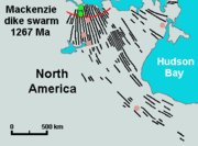
Construction of the Mackenzie dike swarm
Widespread throughout the Mackenzie Large Igneous Province is the 2700000 square kilometre Mackenzie dike swarm. This extensive group of radially oriented dikes is more than 500 km (310.7 mi) wide and 3000 km (1,864.1 mi) long, extending from Northwestern Ontario through northern ManitobaManitoba
Manitoba is a Canadian prairie province with an area of . The province has over 110,000 lakes and has a largely continental climate because of its flat topography. Agriculture, mostly concentrated in the fertile southern and western parts of the province, is vital to the province's economy; other...
and northern Saskatchewan
Saskatchewan
Saskatchewan is a prairie province in Canada, which has an area of . Saskatchewan is bordered on the west by Alberta, on the north by the Northwest Territories, on the east by Manitoba, and on the south by the U.S. states of Montana and North Dakota....
to Nunavut and the Northwest Territories
Northwest Territories
The Northwest Territories is a federal territory of Canada.Located in northern Canada, the territory borders Canada's two other territories, Yukon to the west and Nunavut to the east, and three provinces: British Columbia to the southwest, and Alberta and Saskatchewan to the south...
. The Mackenzie dike swarm was emplaced into older metamorphic and igneous rocks of the Canadian Shield about 1,200 million years ago. Individual dikes of the Mackenzie swarm are respectively 1500 km (932.1 mi) to 2000 km (1,242.7 mi) long and 30 m (98.4 ft) thick. This indicates that the Mackenzie dikes are larger than those associated with the Columbia River Basalt Group
Columbia River Basalt Group
The Columbia River Basalt Group is a large igneous province that lies across parts of the Western United States. It is found in the U.S. states of Washington, Oregon, Idaho, Nevada, and California...
in the United States, which are respectively 400 km (248.5 mi) to 500 km (310.7 mi) long and 10 km (6.2 mi) to 30 km (18.6 mi) thick. The size differentiation of the Columbia River and Mackenzie dikes suggests that the crude estimates for both dike length and thickness ratio are within the ranges for the Mackenzie hotspot and for the early stage of the Yellowstone hotspot.
Archean
The Archean , also spelled Archeozoic or Archæozoic) is a geologic eon before the Paleoproterozoic Era of the Proterozoic Eon, before 2.5 Ga ago. Instead of being based on stratigraphy, this date is defined chronometrically...
and Proterozoic
Proterozoic
The Proterozoic is a geological eon representing a period before the first abundant complex life on Earth. The name Proterozoic comes from the Greek "earlier life"...
rocks of the Canadian Shield, including those in the Athabasca Basin
Athabasca Basin
This article is about the uranium mining region near Lake Athabasca. Not to be confused with the drainage basin of the Athabasca River.The Athabasca Basin is a region of Northern Saskatchewan and Alberta Canada that is best known as the world's leading source of high grade uranium...
in Saskatchewan, the Thelon Basin in Nunavut and the Baker Lake Basin in the Northwest Territories. The mafic dikes display evidence that the unmetamorphosed basin
Basin
Basin may refer to:* Basin , a poem about Charlemagne's childhood* basin , the area of a drydock which can be flooded and drained* basin of attraction , an area of a nonlinear system with an attractor...
-fill sequence was deposited before the Mackenzie dikes were intruded into the associated basins. When the giant Mackenzie dike swarm intruded into the Canadian Shield, it partly uplifted and intruded the Slave craton
Slave craton
The Slave craton is a Canadian geological formation located in the Northwest Territories and Nunavut. This craton is approximately in size and forms part of the Canadian Shield. It is dominated by ca. 2.73-2.63 Ga greenstones and turbidite sequences and ca. 2.72-2.58 Ga plutonic rock, with large...
in the Northwest Territories and Nunavut. This was the last major event to affect the core of the Slave craton, although later on some younger mafic magmatism registered along its boundaries. This includes the magmatic events that formed the 723 million year old Franklin Large Igneous Province and the 780 million year old Hottah gabbro sheets. Since the Mackenzie dike swarm intruded the Slave craton, the craton has been repeatedly submerged under seas.
In northern Yukon
Yukon
Yukon is the westernmost and smallest of Canada's three federal territories. It was named after the Yukon River. The word Yukon means "Great River" in Gwich’in....
, the 1,265 to 1,269 million year old Bear River dikes
Bear River dikes
The Bear River dikes are a 1,265 to 1,269 million year old group of dikes in northern Yukon, Canada. They represent a feature related to magmatism of the extensive Mackenzie Large Igneous Province and are considered to be the western extension of the northwest-southeast trending Mackenzie...
are interpreted to represent the western extension of the Mackenzie dike swarm. They display geologic similarities with the Mackenzie dike swarm and the Coppermine River flood basalts, and are therefore regarded as products of the Mackenzie plume. The dikes intrude through Early Proterozoic sedimentary strata of the Wernecke Supergroup, some of which exist as separate intrusions while others occur in swarms of up to eight dikes. Individual dikes range from 5 m (16.4 ft) to 15 m (49.2 ft) thick and up to 5 km (3.1 mi) long. Medium to fine grained diorite
Diorite
Diorite is a grey to dark grey intermediate intrusive igneous rock composed principally of plagioclase feldspar , biotite, hornblende, and/or pyroxene. It may contain small amounts of quartz, microcline and olivine. Zircon, apatite, sphene, magnetite, ilmenite and sulfides occur as accessory...
and gabbro comprise the Bear River dikes and are occasionally altered by metamorphism to form greenschist
Greenschist
Greenschist is a general field petrologic term applied to metamorphic or altered mafic volcanic rock. The term greenstone is sometimes used to refer to greenschist but can refer to other rock types too. The green is due to abundant green chlorite, actinolite and epidote minerals that dominate the...
. Apart from two dikes that display differentiation, such as containing weak penetrative foliation
Foliation (geology)
Foliation is any penetrative planar fabric present in rocks. Foliation is common to rocks affected by regional metamorphic compression typical of orogenic belts. Rocks exhibiting foliation include the standard sequence formed by the prograde metamorphism of mudrocks; slate, phyllite, schist and...
of unknown age and origin and being cross-cut by undated hematitic
Hematite
Hematite, also spelled as haematite, is the mineral form of iron oxide , one of several iron oxides. Hematite crystallizes in the rhombohedral system, and it has the same crystal structure as ilmenite and corundum...
veins, the Bear River dikes are interpreted to have formed during a single magmatic phase.
Flood basalts
Between 1,200 and 740 million years ago, a series of flood basalt eruptions took place. At the northern portion of the Mackenzie Large Igneous Province, vast volumes of basaltic lava paved over a large area of the northwestern Canadian Shield. This extensive volcanism constructed a large lava plateau with an area of 170000 square kilometre, representing a volume of lavas of at least 500000 km³ (119,956.4 cu mi). This extensive area of flood basalt lava flows has been termed the Coppermine River flood basalts hence given the location of the flood basalt sequence. With an area of 170000 square kilometre and a volume of 650000 km³ (155,943.3 cu mi), the Coppermine River flood basalt sequence is larger than the Columbia River Basalt Group in the United StatesUnited States
The United States of America is a federal constitutional republic comprising fifty states and a federal district...
and comparable in size to the Deccan Traps
Deccan Traps
The Deccan Traps are a large igneous province located on the Deccan Plateau of west-central India and one of the largest volcanic features on Earth. They consist of multiple layers of solidified flood basalt that together are more than thick and cover an area of and a volume of...
in west-central India
India
India , officially the Republic of India , is a country in South Asia. It is the seventh-largest country by geographical area, the second-most populous country with over 1.2 billion people, and the most populous democracy in the world...
. This makes the Coppermine River flood basalts one of the largest flood basalt events ever to appear on the North American continent, as well as on Earth. The maximum thickness of the Coppermine River flood basalts is 4.7 km (2.9 mi) and consist of 150 lava flows, each 4 m (13.1 ft) to 100 m (328.1 ft) thick.
The Coppermine River flood basalts were extruded shorty after a period of crustal uplift that later resulted in a short period of collapse in the associated landscape. This sudden uplift was likely caused by rising magma of the Mackenzie plume, which later resulted in the appearance of the Mackenzie hotspot. The early Muskox intrusion is considered to have originally been a sill-shaped magma reservoir for the overlying Coppermine River flood basalts during their formation. With the Coppermine River basalts comprising more than 100 individual lava flows, the potential volumes of silicate
Silicate
A silicate is a compound containing a silicon bearing anion. The great majority of silicates are oxides, but hexafluorosilicate and other anions are also included. This article focuses mainly on the Si-O anions. Silicates comprise the majority of the earth's crust, as well as the other...
magma that moved through the Muskox conduit were in the order of 10000 km³ (2,399.1 cu mi).
Further to the northeast, the Nauyat Formation
Nauyat Formation
The Nauyat Formation is a Neoproterozoic geologic formation located on northwestern Baffin Island, Nunavut, Canada. It consists of a series of continental flood basalt lava flows of the Mackenzie Large Igneous Province with a thickness of at least .-See also:...
flood basalts on northwestern Baffin Island
Baffin Island
Baffin Island in the Canadian territory of Nunavut is the largest island in the Canadian Arctic Archipelago, the largest island in Canada and the fifth largest island in the world. Its area is and its population is about 11,000...
of Nunavut
Nunavut
Nunavut is the largest and newest federal territory of Canada; it was separated officially from the Northwest Territories on April 1, 1999, via the Nunavut Act and the Nunavut Land Claims Agreement Act, though the actual boundaries had been established in 1993...
were erupted on a smaller scale about 900 million years ago. These flood basalts reach a thickness of 360 m (1,181.1 ft). Just southeast of the Queen Maud Gulf
Queen Maud Gulf
Queen Maud Gulf lies between the northern coast of the mainland and the southeastern corner of Victoria Island in Nunavut, Canada. At its western end lies Cambridge Bay, leading to Dease Strait; to the east lies Simpson Strait; and to the north, Victoria Strait.It was named by the Norwegian...
, the Ekalulia Formation
Ekalulia Formation
The Ekalulia Formation is a Neoproterozoic geologic formation found in Nunavut, Canada. It consists of a series of massive continental flood basalt lava flows of the Mackenzie Large Igneous Province with a thickness of 300-500 m...
flood basalts remain 300 m (984.3 ft) to 500 m (1,640.4 ft) thick. They appear green in colour and contain the magnesium
Magnesium
Magnesium is a chemical element with the symbol Mg, atomic number 12, and common oxidation number +2. It is an alkaline earth metal and the eighth most abundant element in the Earth's crust and ninth in the known universe as a whole...
iron
Iron
Iron is a chemical element with the symbol Fe and atomic number 26. It is a metal in the first transition series. It is the most common element forming the planet Earth as a whole, forming much of Earth's outer and inner core. It is the fourth most common element in the Earth's crust...
silicate
Silicate minerals
The silicate minerals make up the largest and most important class of rock-forming minerals, constituting approximately 90 percent of the crust of the Earth. They are classified based on the structure of their silicate group...
mineral olivine
Olivine
The mineral olivine is a magnesium iron silicate with the formula 2SiO4. It is a common mineral in the Earth's subsurface but weathers quickly on the surface....
. Minor pillow lava
Pillow lava
Pillow lavas are lavas that contain characteristic pillow-shaped structures that are attributed to the extrusion of the lava under water, or subaqueous extrusion. Pillow lavas in volcanic rock are characterized by thick sequences of discontinuous pillow-shaped masses, commonly up to one metre in...
s also exist in the Ekalulia flood basalts.
Mineralization
Heavy platinum groupPlatinum group
The platinum group metals is a term used sometimes to collectively refer to six metallic elements clustered together in the periodic table.These elements are all transition metals, lying in the d-block .The six...
elements and copper mineralization exists in the basal margin of the Muskox intrusion. Research operated by Muskox Minerals Corp. proclaims that this extensive layered intrusion has the possibility to evolve into a massive expected source of copper, nickel
Nickel
Nickel is a chemical element with the chemical symbol Ni and atomic number 28. It is a silvery-white lustrous metal with a slight golden tinge. Nickel belongs to the transition metals and is hard and ductile...
and platinum group metals. The expected mineralization potential for the Muskox intrusion is supported as a result of its strong similarities to the Noril'sk-Talnakh intrusions in Siberia where the richest orebodies
Ore
An ore is a type of rock that contains minerals with important elements including metals. The ores are extracted through mining; these are then refined to extract the valuable element....
exist on Earth. Because the Muskox intrusion has strong similarities to the Noril'sk-Talnakh area in Siberia, a number of mineral explorations have taken place. The first mineral exploration of the Muskox intrusion occurred during the 1950s when surface prospecting began by the International Nickel Company of Canada, which is now known as Vale Inco. In the 1980s, many small companies with little financing and fragmented claim blocks attended sampling and a number of drilling operations on outcroppings of the Muskox intrusion that contained platinum group elements.
Exposed portions of the feeder dike south of the Coppermine River comprise bodies of large semi-massive and disseminated copper-nickel sulfides rich in platinum group metals. At the margins of the Muskox intrusion, sulfide bearing zones more than 10 km (6.2 mi) long contain palladium
Palladium
Palladium is a chemical element with the chemical symbol Pd and an atomic number of 46. It is a rare and lustrous silvery-white metal discovered in 1803 by William Hyde Wollaston. He named it after the asteroid Pallas, which was itself named after the epithet of the Greek goddess Athena, acquired...
, platinum, gold
Gold
Gold is a chemical element with the symbol Au and an atomic number of 79. Gold is a dense, soft, shiny, malleable and ductile metal. Pure gold has a bright yellow color and luster traditionally considered attractive, which it maintains without oxidizing in air or water. Chemically, gold is a...
, copper and nickel. This is the location where casual mineral exploration companies searched the Muskox intrusion in the past.
See also
- Volcanism of Canada
- Volcanism of Northern CanadaVolcanism of Northern CanadaVolcanism of Northern Canada has led to the formation of hundreds of volcanic areas and extensive lava formations across Northern Canada, indicating volcanism played a major role in shaping its surface...
- Volcanism of Eastern CanadaVolcanism of Eastern CanadaVolcanism of Eastern Canada has led to the formation of hundreds of volcanic areas and extensive lava formations, indicating volcanism played a major role in shaping its surface. The region's different volcano and lava types originate from different tectonic settings and types of volcanic...
- Volcanism of Western CanadaVolcanism of Western CanadaVolcanism of Western Canada produces lava flows, lava plateaus, lava domes, cinder cones, stratovolcanoes, shield volcanoes, submarine volcanoes, calderas, diatremes and maars, along with examples of more less common volcanic forms such as tuyas and subglacial mounds.-Volcanic belts:*Anahim...
- Timetable of major worldwide volcanic eruptionsTimetable of major worldwide volcanic eruptionsThis article is a list of volcanic eruptions of approximately at least magnitude 6 on the Volcanic Explosivity Index or equivalent sulfur dioxide emission around the Quaternary period. Some cooled the global climate; the extent of this effect depends on the amount of sulfur dioxide emitted...