
Volcanism of Eastern Canada
Encyclopedia
Volcanism of Eastern Canada has led to the formation of hundreds of volcanic areas and extensive lava formations, indicating volcanism played a major role in shaping its surface. The region's different volcano and lava types originate from different tectonic
settings and types of volcanic eruptions
, ranging from passive lava eruptions
to violent explosive eruption
s. Eastern Canada
has a record of very large volumes of magmatic rock called large igneous province
s. They are represented by deep-level plumbing systems consisting of giant dike swarm
s, sill
provinces and layered intrusion
s. The most capable large igneous provinces in Eastern Canada are Archean
(3,800-2,500 million years ago) age greenstone belt
s containing a rare volcanic rock called komatiite
.
 The 2,677 million year old Abitibi greenstone belt
in Ontario and Quebec is one of the largest Archean greenstone belts on Earth and one of the youngest parts of the Superior craton
which sequentially forms part of the Canadian Shield.
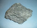
Komatiite
lavas in the Abitibi greenstone belt (pictured) occur in four lithotectonic assemblages known as Pacaud, Stoughton-Roquemaure, Kidd-Munro and Tisdale. The Swayze greenstone belt further south is interpreted to be a southwestern extension of the Abitibi greenstone belt.
Red Lake greenstone belt
in Northwestern Ontario
consists of basaltic and komatiitic volcanics ranging in age from 2,925 to 2,940 million years old and younger rhyolite-andesite volcanics ranging in age from 2,730 to 2,750 million years old. It is situated in the western portion of the Uchi Subprovince
, a volcanic sequence comprising a number of greenstone belts.
constitutes a large igneous province extending for more than 3400 km (2,113 mi) from the Labrador Trough
in Labrador
and northeastern Quebec though the Cape Smith Belt
in northern Quebec, the Belcher Islands
in southern Nunavut
, the Fox River
and Thompson
belts in northern Manitoba
, the Winnipegosis komatiite belt
in central Manitoba, and on the southern side of the Superior craton in the Animikie Basin of northwestern Ontario. Two volcano-sedimentary sequences exist in the Labrador Trough with ages of 2,170-2,140 million years and 1,883-1,870 million years. In the Cape Smith Belt, two volcanic group
s range in age from 2,040 to 1,870 million years old called the Povungnituk volcano-sedimentary Group and the Chukotat Group. The Belcher Islands in eastern Hudson Bay contain two volcanic sequences known as the Flaherty and Eskimo volcanics. The Fox River Belt consists of volcanics, sills and sediments some 1,883 million years old while magmatism of the Thompson Belt is dated to 1,880 million years old. To the south lies the 1,864 million year old Winnipegosis komatiites. In the Animikie Basin near Lake Superior, volcanism is dated 1,880 million years old.
 During the Mesoproterozoic
era of the Precambrian
period 1,109 million years ago, northwestern Ontario began to split apart to form the Midcontinent Rift System
, also called the Keweenawan Rift. Lava flows created by the rift in the Lake Superior
area were formed from basaltic magma. The upwelling of this magma was the result of a hotspot
which produced a triple junction
in the vicinity of Lake Superior. The hotspot made a dome that covered the Lake Superior area. Voluminous basaltic lava flows erupted from the central axis of the rift, similar to the rifting that formed the Atlantic Ocean
. A failed arm
extends 150 km (93 mi) north into mainland Ontario where it forms a geological formation known as the Nipigon Embayment. This failed arm includes Lake Nipigon
, the largest lake entirely within the boundaries of Ontario.
 Periods of volcanic activity occurred throughout central Canada during the Jurassic
and Cretaceous
periods. The source for this volcanism was a long-lived and stationary area of molten rock called the New England or Great Meteor hotspot
. The first event erupted kimberlite magma in the James Bay
lowlands region of northern Ontario 180 million years ago, creating the Attawapiskat kimberlite field
. Another kimberlite event spanned a period of 13 million years 165 to 152 million years ago, creating the Kirkland Lake kimberlite field
in northeastern Ontario. Another period of kimberlite volcanism occurred in northeastern Ontario 154 to 134 million years ago, creating the Lake Timiskaming kimberlite field
. As the North American Plate moved westward over the New England hotspot, the New England hotspot created the magma intrusion
s of the Monteregian Hills in Montreal
in southern Quebec. These intrusive stocks have been variously interpreted as the feeder intrusions of long extinct volcanoes that would have been active 125 million years ago, or as intrusions that never breached the surface in volcanic activity. The lack of a noticeable hotspot track west of the Monteregian Hills might be due either to failure of the New England mantle plume to pass through massive strong rock of the Canadian Shield, the lack of noticeable intrusions, or to strengthening of the New England mantle plume when it approached the Monteregian Hills region.
 About 250 million years ago during the early Triassic
period, Atlantic Canada laid roughly in the middle of a giant continent called Pangaea
. This supercontinent
began to fracture 220 million years ago when the Earth's lithosphere
was being pulled apart from extensional stress, creating a divergent plate boundary
known as the Fundy Basin
. The focus of the rifting began somewhere between where present-day eastern North America and northwestern Africa
were joined. During the formation of the Fundy Basin, volcanic activity never stopped as shown by the going eruption of lava along the Mid-Atlantic Ridge
; an underwater volcanic mountain range
in the Atlantic Ocean
formed as a result of continuous seafloor spreading
between eastern North America and northwestern Africa. As the Fundy Basin continued to form 201 million years ago, a series of basaltic lava flows were erupted, forming a volcanic mountain range on the mainland portion of southwestern Nova Scotia
known as North Mountain
, stretching 200 km (124 mi) from Brier Island
in the south to Cape Split
in the north. This series of lava flows cover most of the Fundy Basin and extend under the Bay of Fundy
where parts of it are exposed on the shore at the rural community of Five Islands
, east of Parrsboro
on the north side of the bay. Large dikes 4 m (13 ft) to 30 m (98 ft) wide exist throughout southernmost New Brunswick with ages and compositions similar to the North Mountain basalt, indicating these dikes were the source for North Mountain lava flows. However, North Mountain is the remnants of a larger volcanic feature that has now been largely eroded based on the existence of basin border faults and erosion. The hard basaltic ridge of North Mountain resisted the grindng of ice sheet
s that flowed over this region during the past ice age
s, and now forms one side of the Annapolis Valley
in the western part of the Nova Scotia peninsula
. The layering of a North Mountain lava flow less than 175 m (574 ft) thick at McKay Head, closely resemble that of some Hawaii
an lava lake
s, indicating Hawaiian eruption
s occurred during the formation of North Mountain.
 The Fogo Seamounts
, located 500 km (311 mi) offshore of Newfoundland to the southwest of the Grand Banks, consists of submarine volcanoes with dates extending back to the Early Cretaceous
period at least 143 million years ago. They may have one or two origins. The Fogo Seamounts could have formed along fracture zones in the Atlantic seafloor because of the large number of seamounts on the North American continental shelf
. The other explanation for their origin is they formed above a mantle plume
associated with the Canary
or Azores hotspot
s in the Atlantic Ocean, based on the existence of older seamounts to the northwest and younger seamounts to the southeast. The existence of flat-topped seamounts
throughout the Fogo Seamount chain indicate some of these seamounts would once have stood above sea level
as islands that would have been volcanically active. Their flatness is due to coastal erosion, such as waves and winds. Other submarine volcanoes offshore of Eastern Canada include the poorly studied Newfoundland Seamounts
.
Tectonics
Tectonics is a field of study within geology concerned generally with the structures within the lithosphere of the Earth and particularly with the forces and movements that have operated in a region to create these structures.Tectonics is concerned with the orogenies and tectonic development of...
settings and types of volcanic eruptions
Types of volcanic eruptions
During a volcanic eruption, lava, tephra , and various gases are expelled from a volcanic vent or fissure. Several types of volcanic eruptions have been distinguished by volcanologists. These are often named after famous volcanoes where that type of behavior has been observed...
, ranging from passive lava eruptions
Effusive eruption
An effusive eruption is a volcanic eruption characterized by the outpouring of lava onto the ground...
to violent explosive eruption
Explosive eruption
An explosive eruption is a volcanic term to describe a violent, explosive type of eruption. Mount St. Helens in 1980 was an example. Such an eruption is driven by gas accumulating under great pressure. Driven by hot rising magma, it interacts with ground water until the pressure increases to the...
s. Eastern Canada
Eastern Canada
Eastern Canada is generally considered to be the region of Canada east of Manitoba, consisting of the following provinces:* New Brunswick* Newfoundland and Labrador* Nova Scotia* Ontario* Prince Edward Island* Quebec...
has a record of very large volumes of magmatic rock called large igneous province
Large igneous province
A Large Igneous Province is an extremely large accumulation of igneous rocks—intrusive, extrusive, or both—in the earth's crust...
s. They are represented by deep-level plumbing systems consisting of giant dike swarm
Dike swarm
A dike swarm or dyke swarm is a large geological structure consisting of a major group of parallel, linear, or radially oriented dikes intruded within continental crust. They consist of several to hundreds of dikes emplaced more or less contemporaneously during a single intrusive event and are...
s, sill
Sill (geology)
In geology, a sill is a tabular sheet intrusion that has intruded between older layers of sedimentary rock, beds of volcanic lava or tuff, or even along the direction of foliation in metamorphic rock. The term sill is synonymous with concordant intrusive sheet...
provinces and layered intrusion
Intrusion
An intrusion is liquid rock that forms under Earth's surface. Magma from under the surface is slowly pushed up from deep within the earth into any cracks or spaces it can find, sometimes pushing existing country rock out of the way, a process that can take millions of years. As the rock slowly...
s. The most capable large igneous provinces in Eastern Canada are Archean
Archean
The Archean , also spelled Archeozoic or Archæozoic) is a geologic eon before the Paleoproterozoic Era of the Proterozoic Eon, before 2.5 Ga ago. Instead of being based on stratigraphy, this date is defined chronometrically...
(3,800-2,500 million years ago) age greenstone belt
Greenstone belt
Greenstone belts are zones of variably metamorphosed mafic to ultramafic volcanic sequences with associated sedimentary rocks that occur within Archaean and Proterozoic cratons between granite and gneiss bodies....
s containing a rare volcanic rock called komatiite
Komatiite
Komatiite is a type of ultramafic mantle-derived volcanic rock. Komatiites have low silicon, potassium and aluminium, and high to extremely high magnesium content...
.
Abitibi greenstone belt
Abitibi greenstone belt
The Abitibi greenstone belt is a 2,800-2,600 million year old greenstone belt that spans across the Ontario-Quebec border in Canada. It is mostly made of volcanic rocks, but also includes ultramafic rocks, mafic intrusions, granitoid rocks, and early and middle Precambrian sediments.-Geographical...
in Ontario and Quebec is one of the largest Archean greenstone belts on Earth and one of the youngest parts of the Superior craton
Superior craton
The Superior craton forms the core of the Canadian Shield at the heart of the North American continent. It extends from Quebec in the east to eastern Manitoba in the west...
which sequentially forms part of the Canadian Shield.
Komatiite
Komatiite
Komatiite is a type of ultramafic mantle-derived volcanic rock. Komatiites have low silicon, potassium and aluminium, and high to extremely high magnesium content...
lavas in the Abitibi greenstone belt (pictured) occur in four lithotectonic assemblages known as Pacaud, Stoughton-Roquemaure, Kidd-Munro and Tisdale. The Swayze greenstone belt further south is interpreted to be a southwestern extension of the Abitibi greenstone belt.
Red Lake greenstone belt
The ArcheanArchean
The Archean , also spelled Archeozoic or Archæozoic) is a geologic eon before the Paleoproterozoic Era of the Proterozoic Eon, before 2.5 Ga ago. Instead of being based on stratigraphy, this date is defined chronometrically...
Red Lake greenstone belt
Red Lake greenstone belt
The Red Lake greenstone belt is an Archean greenstone belt at the town of Red Lake in Northwestern Ontario, Canada. It consists of basaltic and komatiitic volcanics ranging in age from 2,925 to 2,940 million years old and younger rhyolite-andesite volcanics ranging in age from...
in Northwestern Ontario
Northwestern Ontario
Northwestern Ontario is the region within the Canadian province of Ontario which lies north and west of Lake Superior, and west of Hudson Bay and James Bay. It includes most of subarctic Ontario. Its western boundary is the Canadian province of Manitoba, which disputed Ontario's claim to the...
consists of basaltic and komatiitic volcanics ranging in age from 2,925 to 2,940 million years old and younger rhyolite-andesite volcanics ranging in age from 2,730 to 2,750 million years old. It is situated in the western portion of the Uchi Subprovince
Uchi Subprovince
The Uchi Subprovince is a Neoarchean volcanic sequence in Manitoba, Canada. It is the southern margin of the North Caribou terrane and comprises a number of greenstone belts, which contains volcanic rocks that record some 280 million years of volcanism....
, a volcanic sequence comprising a number of greenstone belts.
Circum-Superior Belt
The 1884-1864 million year old Circum-Superior BeltCircum-Superior Belt
The Circum-Superior Belt is a widespread Paleoproterozoic large igneous province in the Canadian Shield of Northern, Western and Eastern Canada. It extends more than from northeastern Manitoba through northwestern Ontario, southern Nunavut to northern Quebec...
constitutes a large igneous province extending for more than 3400 km (2,113 mi) from the Labrador Trough
Labrador Trough
The Labrador Trough or the New Quebec Orogen is a long and wide geologic belt in Canada, extending south-southeast from Ungava Bay through Quebec and Labrador....
in Labrador
Labrador
Labrador is the distinct, northerly region of the Canadian province of Newfoundland and Labrador. It comprises the mainland portion of the province, separated from the island of Newfoundland by the Strait of Belle Isle...
and northeastern Quebec though the Cape Smith Belt
Cape Smith Belt
The Cape Smith Belt is an early Proterozoic thrust belt in northern Quebec, Canada....
in northern Quebec, the Belcher Islands
Belcher Islands
The Belcher Islands are an archipelago in Qikiqtaaluk Region, Nunavut, Canada. Located in Hudson Bay, the Belcher Islands are spread out over almost . The hamlet of Sanikiluaq is on the north coast of Flaherty Island and is the southernmost in Nunavut. Along with Flaherty Island, the other large...
in southern Nunavut
Nunavut
Nunavut is the largest and newest federal territory of Canada; it was separated officially from the Northwest Territories on April 1, 1999, via the Nunavut Act and the Nunavut Land Claims Agreement Act, though the actual boundaries had been established in 1993...
, the Fox River
Fox River Belt
The Fox River Belt is a long and to wide Paleoproterozoic geologic feature located in northern Manitoba, Canada. It consists of sedimentary and mafic/ultramafic igneous rocks....
and Thompson
Thompson Belt
The Thompson Belt, also referred to as the Thompson Nickel Belt, is an Archean and early Proterozoic geologic feature in Manitoba, Canada. It contains gneiss related to deformation of the Trans-Hudson orogeny....
belts in northern Manitoba
Manitoba
Manitoba is a Canadian prairie province with an area of . The province has over 110,000 lakes and has a largely continental climate because of its flat topography. Agriculture, mostly concentrated in the fertile southern and western parts of the province, is vital to the province's economy; other...
, the Winnipegosis komatiite belt
Winnipegosis komatiite belt
The Winnipegosis komatiite belt, also called the Winnipegosis komatiites, is a volcanic belt composed of komatiite in central Manitoba, Canada. It is part of a large igneous province surrounding much of the Superior craton called the Circum-Superior Belt....
in central Manitoba, and on the southern side of the Superior craton in the Animikie Basin of northwestern Ontario. Two volcano-sedimentary sequences exist in the Labrador Trough with ages of 2,170-2,140 million years and 1,883-1,870 million years. In the Cape Smith Belt, two volcanic group
Volcanic group
A volcanic group is a collection of related volcanoes or volcanic landforms. Note that the term is also used in a different sense when it denotes a suite of associated rock strata largely of volcanic origin; see group for details.-Notable volcanic groups:-See also:*Complex...
s range in age from 2,040 to 1,870 million years old called the Povungnituk volcano-sedimentary Group and the Chukotat Group. The Belcher Islands in eastern Hudson Bay contain two volcanic sequences known as the Flaherty and Eskimo volcanics. The Fox River Belt consists of volcanics, sills and sediments some 1,883 million years old while magmatism of the Thompson Belt is dated to 1,880 million years old. To the south lies the 1,864 million year old Winnipegosis komatiites. In the Animikie Basin near Lake Superior, volcanism is dated 1,880 million years old.
Midcontinent Rift System
Mesoproterozoic
The Mesoproterozoic Era is a geologic era that occurred between 1600 Ma and 1000 Ma . The Mesoproterozoic was the first period of Earth's history with a respectable geological record. Continents existed in the Paleoproterozoic, but we know little about them...
era of the Precambrian
Precambrian
The Precambrian is the name which describes the large span of time in Earth's history before the current Phanerozoic Eon, and is a Supereon divided into several eons of the geologic time scale...
period 1,109 million years ago, northwestern Ontario began to split apart to form the Midcontinent Rift System
Midcontinent Rift System
The Midcontinent Rift System or Keweenawan Rift is a long geological rift in the center of the North American continent and south-central part of the North American plate. It formed when the continent's core, the North American craton, began to split apart during the Mesoproterozoic era of the...
, also called the Keweenawan Rift. Lava flows created by the rift in the Lake Superior
Lake Superior
Lake Superior is the largest of the five traditionally-demarcated Great Lakes of North America. It is bounded to the north by the Canadian province of Ontario and the U.S. state of Minnesota, and to the south by the U.S. states of Wisconsin and Michigan. It is the largest freshwater lake in the...
area were formed from basaltic magma. The upwelling of this magma was the result of a hotspot
Hotspot (geology)
The places known as hotspots or hot spots in geology are volcanic regions thought to be fed by underlying mantle that is anomalously hot compared with the mantle elsewhere. They may be on, near to, or far from tectonic plate boundaries. There are two hypotheses to explain them...
which produced a triple junction
Triple junction
A triple junction is the point where the boundaries of three tectonic plates meet. At the triple junction a boundary will be one of 3 types - a ridge, trench or transform fault - and triple junctions can be described according to the types of plate margin that meet at them...
in the vicinity of Lake Superior. The hotspot made a dome that covered the Lake Superior area. Voluminous basaltic lava flows erupted from the central axis of the rift, similar to the rifting that formed the Atlantic Ocean
Atlantic Ocean
The Atlantic Ocean is the second-largest of the world's oceanic divisions. With a total area of about , it covers approximately 20% of the Earth's surface and about 26% of its water surface area...
. A failed arm
Aulacogen
In geology, an aulacogen is a failed arm of a triple junction of a plate tectonics rift system. A triple junction beneath a continental plate initiates a three way breakup of the continental plate. As the continental break-up develops one of the three spreading ridges typically fails or stops...
extends 150 km (93 mi) north into mainland Ontario where it forms a geological formation known as the Nipigon Embayment. This failed arm includes Lake Nipigon
Lake Nipigon
Lake Nipigon is the largest lake entirely within the boundaries of the Canadian province of Ontario . It is sometimes described as the sixth Great Lake. Lying 260 metres above sea level, the lake drains into the Nipigon River and thence into Nipigon Bay of Lake Superior...
, the largest lake entirely within the boundaries of Ontario.
New England hotspot track
Jurassic
The Jurassic is a geologic period and system that extends from about Mya to Mya, that is, from the end of the Triassic to the beginning of the Cretaceous. The Jurassic constitutes the middle period of the Mesozoic era, also known as the age of reptiles. The start of the period is marked by...
and Cretaceous
Cretaceous
The Cretaceous , derived from the Latin "creta" , usually abbreviated K for its German translation Kreide , is a geologic period and system from circa to million years ago. In the geologic timescale, the Cretaceous follows the Jurassic period and is followed by the Paleogene period of the...
periods. The source for this volcanism was a long-lived and stationary area of molten rock called the New England or Great Meteor hotspot
New England hotspot
The New England hotspot, also referred to as the Great Meteor hotspot, is a long-lived volcanic hotspot in the Atlantic Ocean. The hotspot's most recent eruptive center is the Great Meteor Seamount, and it probably created a short line of mid to late-Tertiary age seamounts on the African Plate but...
. The first event erupted kimberlite magma in the James Bay
James Bay
James Bay is a large body of water on the southern end of Hudson Bay in Canada. Both bodies of water extend from the Arctic Ocean. James Bay borders the provinces of Quebec and Ontario; islands within the bay are part of Nunavut...
lowlands region of northern Ontario 180 million years ago, creating the Attawapiskat kimberlite field
Attawapiskat kimberlite field
The Attawapiskat kimberlite field is a field of diatremes located astride the Attawapiskat River in the Hudson Bay Lowlands, in Northern Ontario, Canada...
. Another kimberlite event spanned a period of 13 million years 165 to 152 million years ago, creating the Kirkland Lake kimberlite field
Kirkland Lake kimberlite field
The Kirkland Lake kimberlite field is a 165 to 152 million year old kimberlite field in the Kirkland Lake area of northeastern Ontario, Canada.-See also:*Volcanism of Canada*Volcanism of Eastern Canada*List of volcanoes in Canada...
in northeastern Ontario. Another period of kimberlite volcanism occurred in northeastern Ontario 154 to 134 million years ago, creating the Lake Timiskaming kimberlite field
Lake Timiskaming kimberlite field
The Lake Timiskaming kimberlite field is Canada's southermost kimberlite field, located in Northeastern Ontario and western Quebec, Canada. It is within the Lake Timiskaming Structural Zone which contains over 50 kimberlite pipes, several of which are diamondiferous...
. As the North American Plate moved westward over the New England hotspot, the New England hotspot created the magma intrusion
Intrusion
An intrusion is liquid rock that forms under Earth's surface. Magma from under the surface is slowly pushed up from deep within the earth into any cracks or spaces it can find, sometimes pushing existing country rock out of the way, a process that can take millions of years. As the rock slowly...
s of the Monteregian Hills in Montreal
Montreal
Montreal is a city in Canada. It is the largest city in the province of Quebec, the second-largest city in Canada and the seventh largest in North America...
in southern Quebec. These intrusive stocks have been variously interpreted as the feeder intrusions of long extinct volcanoes that would have been active 125 million years ago, or as intrusions that never breached the surface in volcanic activity. The lack of a noticeable hotspot track west of the Monteregian Hills might be due either to failure of the New England mantle plume to pass through massive strong rock of the Canadian Shield, the lack of noticeable intrusions, or to strengthening of the New England mantle plume when it approached the Monteregian Hills region.
Fundy Basin
Triassic
The Triassic is a geologic period and system that extends from about 250 to 200 Mya . As the first period of the Mesozoic Era, the Triassic follows the Permian and is followed by the Jurassic. Both the start and end of the Triassic are marked by major extinction events...
period, Atlantic Canada laid roughly in the middle of a giant continent called Pangaea
Pangaea
Pangaea, Pangæa, or Pangea is hypothesized as a supercontinent that existed during the Paleozoic and Mesozoic eras about 250 million years ago, before the component continents were separated into their current configuration....
. This supercontinent
Supercontinent
In geology, a supercontinent is a landmass comprising more than one continental core, or craton. The assembly of cratons and accreted terranes that form Eurasia qualifies as a supercontinent today.-History:...
began to fracture 220 million years ago when the Earth's lithosphere
Lithosphere
The lithosphere is the rigid outermost shell of a rocky planet. On Earth, it comprises the crust and the portion of the upper mantle that behaves elastically on time scales of thousands of years or greater.- Earth's lithosphere :...
was being pulled apart from extensional stress, creating a divergent plate boundary
Divergent boundary
In plate tectonics, a divergent boundary or divergent plate boundary is a linear feature that exists between two tectonic plates that are moving away from each other. Divergent boundaries within continents initially produce rifts which produce rift valleys...
known as the Fundy Basin
Fundy Basin
The Fundy Basin is a sediment-filled rift basin on the Atlantic coast of southeastern Canada. It contains three sub-basins; the Fundy sub-basin, the Minas Basin and the Chignecto Basin. These arms meet at the Bay of Fundy, which is contained within the rift valley. From the Bay of Fundy, the Minas...
. The focus of the rifting began somewhere between where present-day eastern North America and northwestern Africa
Africa
Africa is the world's second largest and second most populous continent, after Asia. At about 30.2 million km² including adjacent islands, it covers 6% of the Earth's total surface area and 20.4% of the total land area...
were joined. During the formation of the Fundy Basin, volcanic activity never stopped as shown by the going eruption of lava along the Mid-Atlantic Ridge
Mid-Atlantic Ridge
The Mid-Atlantic Ridge is a mid-ocean ridge, a divergent tectonic plate boundary located along the floor of the Atlantic Ocean, and part of the longest mountain range in the world. It separates the Eurasian Plate and North American Plate in the North Atlantic, and the African Plate from the South...
; an underwater volcanic mountain range
Mountain range
A mountain range is a single, large mass consisting of a succession of mountains or narrowly spaced mountain ridges, with or without peaks, closely related in position, direction, formation, and age; a component part of a mountain system or of a mountain chain...
in the Atlantic Ocean
Atlantic Ocean
The Atlantic Ocean is the second-largest of the world's oceanic divisions. With a total area of about , it covers approximately 20% of the Earth's surface and about 26% of its water surface area...
formed as a result of continuous seafloor spreading
Seafloor spreading
Seafloor spreading is a process that occurs at mid-ocean ridges, where new oceanic crust is formed through volcanic activity and then gradually moves away from the ridge. Seafloor spreading helps explain continental drift in the theory of plate tectonics....
between eastern North America and northwestern Africa. As the Fundy Basin continued to form 201 million years ago, a series of basaltic lava flows were erupted, forming a volcanic mountain range on the mainland portion of southwestern Nova Scotia
Nova Scotia peninsula
The Nova Scotia peninsula is a peninsula on the Atlantic coast of North America.-Location:The Nova Scotia peninsula is part of the province of Nova Scotia, Canada and is connected to the neighbouring province of New Brunswick through the Isthmus of Chignecto...
known as North Mountain
North Mountain (Nova Scotia)
North Mountain is a narrow southwest-northeast trending volcanic mountain range on the mainland portion of southwestern Nova Scotia, stretching from Brier Island to Cape Split...
, stretching 200 km (124 mi) from Brier Island
Brier Island
Brier Island is an island in the Bay of Fundy in Digby County, Nova Scotia.-Geography:The island is the western-most part of Nova Scotia and the southern end of the North Mountain ridge with Long Island lying immediately northeast; both islands constitute part of the Digby Neck...
in the south to Cape Split
Cape Split
Cape Split is a headland located on the Bay of Fundy coast of the Canadian province of Nova Scotia.Cape Split is located in Kings County and is a continuation of the North Mountain range, which is made of tholeiitic basalt...
in the north. This series of lava flows cover most of the Fundy Basin and extend under the Bay of Fundy
Bay of Fundy
The Bay of Fundy is a bay on the Atlantic coast of North America, on the northeast end of the Gulf of Maine between the Canadian provinces of New Brunswick and Nova Scotia, with a small portion touching the U.S. state of Maine...
where parts of it are exposed on the shore at the rural community of Five Islands
Five Islands, Nova Scotia
Five Islands is a rural community in Colchester County Nova Scotia with a population of 300 located on the north shore of the Minas Basin, home of the highest tides in the world...
, east of Parrsboro
Parrsboro, Nova Scotia
Parrsboro is a Canadian town located in Cumberland County, Nova Scotia.The town is known for its port on the Minas Basin, the Ship's Company Theatre productions and the Fundy Geological Museum.-History:...
on the north side of the bay. Large dikes 4 m (13 ft) to 30 m (98 ft) wide exist throughout southernmost New Brunswick with ages and compositions similar to the North Mountain basalt, indicating these dikes were the source for North Mountain lava flows. However, North Mountain is the remnants of a larger volcanic feature that has now been largely eroded based on the existence of basin border faults and erosion. The hard basaltic ridge of North Mountain resisted the grindng of ice sheet
Ice sheet
An ice sheet is a mass of glacier ice that covers surrounding terrain and is greater than 50,000 km² , thus also known as continental glacier...
s that flowed over this region during the past ice age
Ice age
An ice age or, more precisely, glacial age, is a generic geological period of long-term reduction in the temperature of the Earth's surface and atmosphere, resulting in the presence or expansion of continental ice sheets, polar ice sheets and alpine glaciers...
s, and now forms one side of the Annapolis Valley
Annapolis Valley
The Annapolis Valley is a valley and region in the Canadian province of Nova Scotia. It is located in the western part of the Nova Scotia peninsula, formed by a trough between two parallel mountain ranges along the shore of the Bay of Fundy.-Geography:...
in the western part of the Nova Scotia peninsula
Nova Scotia peninsula
The Nova Scotia peninsula is a peninsula on the Atlantic coast of North America.-Location:The Nova Scotia peninsula is part of the province of Nova Scotia, Canada and is connected to the neighbouring province of New Brunswick through the Isthmus of Chignecto...
. The layering of a North Mountain lava flow less than 175 m (574 ft) thick at McKay Head, closely resemble that of some Hawaii
Hawaii
Hawaii is the newest of the 50 U.S. states , and is the only U.S. state made up entirely of islands. It is the northernmost island group in Polynesia, occupying most of an archipelago in the central Pacific Ocean, southwest of the continental United States, southeast of Japan, and northeast of...
an lava lake
Lava lake
Lava lakes are large volumes of molten lava, usually basaltic, contained in a volcanic vent, crater, or broad depression. The term is used to describe both lava lakes that are wholly or partly molten and those that are solidified...
s, indicating Hawaiian eruption
Hawaiian eruption
A Hawaiian eruption is a type of volcanic eruption where lava flows from the vent in a relative gentle, low level eruption, so called because it is characteristic of Hawaiian volcanoes. Typically they are effusive eruptions, with basaltic magmas of low viscosity, low content of gases, and high...
s occurred during the formation of North Mountain.
Seamounts
Fogo Seamounts
The Fogo Seamounts, also called the Fogo Seamount chain, are a group of seamounts located about offshore of Newfoundland and southwest of the Grand Banks of Newfoundland. They consist of basaltic submarine volcanoes that formed during the Early Cretaceous period.The volcanic activity that formed...
, located 500 km (311 mi) offshore of Newfoundland to the southwest of the Grand Banks, consists of submarine volcanoes with dates extending back to the Early Cretaceous
Early Cretaceous
The Early Cretaceous or the Lower Cretaceous , is the earlier or lower of the two major divisions of the Cretaceous...
period at least 143 million years ago. They may have one or two origins. The Fogo Seamounts could have formed along fracture zones in the Atlantic seafloor because of the large number of seamounts on the North American continental shelf
Continental shelf
The continental shelf is the extended perimeter of each continent and associated coastal plain. Much of the shelf was exposed during glacial periods, but is now submerged under relatively shallow seas and gulfs, and was similarly submerged during other interglacial periods. The continental margin,...
. The other explanation for their origin is they formed above a mantle plume
Mantle plume
A mantle plume is a hypothetical thermal diapir of abnormally hot rock that nucleates at the core-mantle boundary and rises through the Earth's mantle. Such plumes were invoked in 1971 to explain volcanic regions that were not thought to be explicable by the then-new theory of plate tectonics. Some...
associated with the Canary
Canary hotspot
The Canary hotspot, also called the Canarian hotspot, is a volcanic hotspot believed to be located at the Canary Islands off the north-western coast of Africa, although alternative theories to explain the volcanism there exist. The Canary hotspot is believed to be underlain by a mantle plume that...
or Azores hotspot
Azores hotspot
The Azores hotspot is a volcanic hotspot located at the Azores in the northern Atlantic Ocean. It has interactions with the Mid-Atlantic Ridge which lies just west of the hotspot.-References:**...
s in the Atlantic Ocean, based on the existence of older seamounts to the northwest and younger seamounts to the southeast. The existence of flat-topped seamounts
Guyot
A guyot , also known as a tablemount, is an isolated underwater volcanic mountain , with a flat top over 200 meters below the surface of the sea. The diameters of these flat summits can exceed ....
throughout the Fogo Seamount chain indicate some of these seamounts would once have stood above sea level
Sea level
Mean sea level is a measure of the average height of the ocean's surface ; used as a standard in reckoning land elevation...
as islands that would have been volcanically active. Their flatness is due to coastal erosion, such as waves and winds. Other submarine volcanoes offshore of Eastern Canada include the poorly studied Newfoundland Seamounts
Newfoundland Seamounts
The Newfoundland Seamounts are a group of seamounts offshore of Eastern Canada in the northern Atlantic Ocean. Named for the island of Newfoundland, this group of seamounts formed during the Cretaceous period and are poorly studied.-See also:...
.
See also
- Volcanism of Canada
- Volcanism of Western CanadaVolcanism of Western CanadaVolcanism of Western Canada produces lava flows, lava plateaus, lava domes, cinder cones, stratovolcanoes, shield volcanoes, submarine volcanoes, calderas, diatremes and maars, along with examples of more less common volcanic forms such as tuyas and subglacial mounds.-Volcanic belts:*Anahim...
- Volcanism of Northern CanadaVolcanism of Northern CanadaVolcanism of Northern Canada has led to the formation of hundreds of volcanic areas and extensive lava formations across Northern Canada, indicating volcanism played a major role in shaping its surface...
- List of volcanoes in Canada