

Yellowstone hotspot
Encyclopedia

Volcano
2. Bedrock3. Conduit 4. Base5. Sill6. Dike7. Layers of ash emitted by the volcano8. Flank| 9. Layers of lava emitted by the volcano10. Throat11. Parasitic cone12. Lava flow13. Vent14. Crater15...
hotspot
Hotspot (geology)
The places known as hotspots or hot spots in geology are volcanic regions thought to be fed by underlying mantle that is anomalously hot compared with the mantle elsewhere. They may be on, near to, or far from tectonic plate boundaries. There are two hypotheses to explain them...
responsible for large scale volcanism in Oregon
Oregon
Oregon is a state in the Pacific Northwest region of the United States. It is located on the Pacific coast, with Washington to the north, California to the south, Nevada on the southeast and Idaho to the east. The Columbia and Snake rivers delineate much of Oregon's northern and eastern...
, Nevada
Nevada
Nevada is a state in the western, mountain west, and southwestern regions of the United States. With an area of and a population of about 2.7 million, it is the 7th-largest and 35th-most populous state. Over two-thirds of Nevada's people live in the Las Vegas metropolitan area, which contains its...
, Idaho
Idaho
Idaho is a state in the Rocky Mountain area of the United States. The state's largest city and capital is Boise. Residents are called "Idahoans". Idaho was admitted to the Union on July 3, 1890, as the 43rd state....
, and Wyoming
Wyoming
Wyoming is a state in the mountain region of the Western United States. The western two thirds of the state is covered mostly with the mountain ranges and rangelands in the foothills of the Eastern Rocky Mountains, while the eastern third of the state is high elevation prairie known as the High...
, United States
United States
The United States of America is a federal constitutional republic comprising fifty states and a federal district...
. It created the eastern Snake River Plain
Snake River Plain
The Snake River Plain is a geologic feature located primarily within the state of Idaho in the United States of America. It stretches about westward from northwest of the state of Wyoming to the Idaho-Oregon border. The plain is a wide flat bow-shaped depression, and covers about a quarter of Idaho...
through a succession of caldera forming eruptions. The resulting calderas include the Island Park Caldera
Island Park Caldera
The volcanic feature commonly called the Island Park Caldera in the states of Idaho and Wyoming, U.S., is actually two calderas, one nested inside the other. The Island Park Caldera is the older and much larger caldera, with approximate dimensions of 58 miles by 40 miles...
, the Henry's Fork Caldera
Henry's Fork Caldera
The Henry's Fork Caldera in Idaho is a caldera located an area known as Island Park west of Yellowstone National Park. The caldera was formed by one of the world's supervolcanos in an eruption of more than 280 cubic kilometers 1.3 million years BP, and is the source of the Mesa Falls Tuff.The...
, and the Bruneau-Jarbidge caldera. The hotspot currently lies under the Yellowstone Caldera
Yellowstone Caldera
The Yellowstone Caldera is the volcanic caldera located in Yellowstone National Park in the United States, sometimes referred to as the Yellowstone Supervolcano. The caldera is located in the northwest corner of Wyoming, in which the vast majority of the park is contained. The major features of...
.
Snake River Plain
The eastern Snake River Plain is a topographic depression that cuts across Basin and RangeBasin and Range
The Basin and Range Province is a vast physiographic region defined by a unique topographic expression. Basin and Range topography is characterized by abrupt changes in elevation, alternating between narrow faulted mountain chains and flat arid valleys or basins...
Mountain structures, more or less parallel to North American plate
North American Plate
The North American Plate is a tectonic plate covering most of North America, Greenland, Cuba, Bahamas, and parts of Siberia, Japan and Iceland. It extends eastward to the Mid-Atlantic Ridge and westward to the Chersky Range in eastern Siberia. The plate includes both continental and oceanic crust...
motion. Beneath more recent basalt
Basalt
Basalt is a common extrusive volcanic rock. It is usually grey to black and fine-grained due to rapid cooling of lava at the surface of a planet. It may be porphyritic containing larger crystals in a fine matrix, or vesicular, or frothy scoria. Unweathered basalt is black or grey...
s are rhyolite
Rhyolite
This page is about a volcanic rock. For the ghost town see Rhyolite, Nevada, and for the satellite system, see Rhyolite/Aquacade.Rhyolite is an igneous, volcanic rock, of felsic composition . It may have any texture from glassy to aphanitic to porphyritic...
lava
Lava
Lava refers both to molten rock expelled by a volcano during an eruption and the resulting rock after solidification and cooling. This molten rock is formed in the interior of some planets, including Earth, and some of their satellites. When first erupted from a volcanic vent, lava is a liquid at...
s and ignimbrite
Ignimbrite
An ignimbrite is the deposit of a pyroclastic density current, or pyroclastic flow, a hot suspension of particles and gases that flows rapidly from a volcano, driven by a greater density than the surrounding atmosphere....
s that erupted as the lithosphere
Lithosphere
The lithosphere is the rigid outermost shell of a rocky planet. On Earth, it comprises the crust and the portion of the upper mantle that behaves elastically on time scales of thousands of years or greater.- Earth's lithosphere :...
passed over the hotspot
Hotspot (geology)
The places known as hotspots or hot spots in geology are volcanic regions thought to be fed by underlying mantle that is anomalously hot compared with the mantle elsewhere. They may be on, near to, or far from tectonic plate boundaries. There are two hypotheses to explain them...
. Younger volcano
Volcano
2. Bedrock3. Conduit 4. Base5. Sill6. Dike7. Layers of ash emitted by the volcano8. Flank| 9. Layers of lava emitted by the volcano10. Throat11. Parasitic cone12. Lava flow13. Vent14. Crater15...
es that erupted after passing over the hotspot covered the plain with young basalt lava flows in places, including Craters of the Moon National Monument.
The central Snake River plain is similar to the eastern plain, but differs by having thick sections of interbedded lacustrine
Lake
A lake is a body of relatively still fresh or salt water of considerable size, localized in a basin, that is surrounded by land. Lakes are inland and not part of the ocean and therefore are distinct from lagoons, and are larger and deeper than ponds. Lakes can be contrasted with rivers or streams,...
(lake) and fluvial
Fluvial
Fluvial is used in geography and Earth science to refer to the processes associated with rivers and streams and the deposits and landforms created by them...
(stream) sediment
Sediment
Sediment is naturally occurring material that is broken down by processes of weathering and erosion, and is subsequently transported by the action of fluids such as wind, water, or ice, and/or by the force of gravity acting on the particle itself....
s, including the Hagerman Fossil Beds
Hagerman Fossil Beds National Monument
Hagerman Fossil Beds National Monument near Hagerman, Idaho, contains the largest concentration of Hagerman Horse fossils in North America. The fossil horses for which the Monument is famous have been found in only one locale in the northern portion of the Monument called the Hagerman Horse Quarry...
.
Nevada-Oregon calderas
Although the McDermitt volcanic field on the Nevada-Oregon border is frequently shown as the site of the initial impingement of the Yellowstone Hotspot, new geochronology and mapping demonstrates that the area affected by this mid-MioceneMiocene
The Miocene is a geological epoch of the Neogene Period and extends from about . The Miocene was named by Sir Charles Lyell. Its name comes from the Greek words and and means "less recent" because it has 18% fewer modern sea invertebrates than the Pliocene. The Miocene follows the Oligocene...
volcanism is significantly larger than previously appreciated. Three silicic calderas have been newly identified in northwest Nevada, west of the McDermitt volcanic field as well as the Virgin Valley Caldera. These calderas, along with the Virgin Valley and McDermitt Calderas, are interpreted to have formed during a short interval 16.5-15.5 million years ago, in the waning stage of the Steens flood basalt volcanism. The northwest Nevada calderas have diameters ranging from 15–26 km and deposited high temperature rhyolite ignimbrites over approximately 5000 km2.
The Bruneau-Jarbidge caldera erupted between ten and twelve million years ago, spreading a thick blanket of ash
Volcanic ash
Volcanic ash consists of small tephra, which are bits of pulverized rock and glass created by volcanic eruptions, less than in diameter. There are three mechanisms of volcanic ash formation: gas release under decompression causing magmatic eruptions; thermal contraction from chilling on contact...
in the Bruneau-Jarbidge event and forming a wide caldera. Animals were suffocated and burned in pyroclastic flow
Pyroclastic flow
A pyroclastic flow is a fast-moving current of superheated gas and rock , which reaches speeds moving away from a volcano of up to 700 km/h . The flows normally hug the ground and travel downhill, or spread laterally under gravity...
s within a hundred miles of the event, and died of slow suffocation and starvation much farther away, notably at Ashfall Fossil Beds
Ashfall Fossil Beds
The Ashfall Fossil Beds of Antelope County in northeastern Nebraska are among the rare preservation sites called lagerstätten, which preserve ecological "snapshots" from a moment in time, due to extraordinary local conditions that have preserved a range of fossilized organisms undisturbed.The...
, located 1000 miles downwind in northeastern Nebraska
Nebraska
Nebraska is a state on the Great Plains of the Midwestern United States. The state's capital is Lincoln and its largest city is Omaha, on the Missouri River....
, where a foot of ash was deposited. There, two hundred fossil
Fossil
Fossils are the preserved remains or traces of animals , plants, and other organisms from the remote past...
ized rhinoceros
Rhinoceros
Rhinoceros , also known as rhino, is a group of five extant species of odd-toed ungulates in the family Rhinocerotidae. Two of these species are native to Africa and three to southern Asia....
and many other animals were preserved in two meters of volcanic ash. By its characteristic chemical fingerprint and the distinctive size and shape of its crystals and glass shards, the volcano stands out among dozens of prominent ashfall horizons laid down in the Cretaceous
Cretaceous
The Cretaceous , derived from the Latin "creta" , usually abbreviated K for its German translation Kreide , is a geologic period and system from circa to million years ago. In the geologic timescale, the Cretaceous follows the Jurassic period and is followed by the Paleogene period of the...
, Paleogene
Paleogene
The Paleogene is a geologic period and system that began 65.5 ± 0.3 and ended 23.03 ± 0.05 million years ago and comprises the first part of the Cenozoic Era...
, and Neogene
Neogene
The Neogene is a geologic period and system in the International Commission on Stratigraphy Geologic Timescale starting 23.03 ± 0.05 million years ago and ending 2.588 million years ago...
periods of central North America. The event responsible for this fall of volcanic ash was identified as Bruneau-Jarbidge. Prevailing westerlies deposited distal ashfall over a vast area of the Great Plains
Great Plains
The Great Plains are a broad expanse of flat land, much of it covered in prairie, steppe and grassland, which lies west of the Mississippi River and east of the Rocky Mountains in the United States and Canada. This area covers parts of the U.S...
.
Twin Falls and Picabo volcanic fields
Twin Falls volcanic field and Picabo volcanic field were active about 10 million years ago. The Picabo Caldera was notable for producing the Arbon Valley Tuff 10.2 million years ago. The Heise volcanic field of eastern Idaho produced explosive caldera-forming eruptions which began 6.6 million years ago and lasted for more than 2 million years, sequentially producing four large-volume rhyolitic eruptions. The first three caldera-forming rhyolites - Blacktail Tuff, Walcott Tuff and Conant Creek Tuff - totaled at least 2250 km3 of erupted magma. The final, extremely volumous, caldera-forming eruption - the Kilgore Tuff - which erupted 1800 km3 of ash, occurred 4.5 million years ago.Yellowstone Plateau
Yellowstone Plateau
The Yellowstone Plateau volcanic field is a geological feature found in the U.S. state of Wyoming. It is a popular site for tourists.The plateau developed through three volcanic cycles spanning two million years that included some of the world's largest known eruptions...
volcanic field is composed of three adjacent calderas. The Henry's Fork Caldera
Henry's Fork Caldera
The Henry's Fork Caldera in Idaho is a caldera located an area known as Island Park west of Yellowstone National Park. The caldera was formed by one of the world's supervolcanos in an eruption of more than 280 cubic kilometers 1.3 million years BP, and is the source of the Mesa Falls Tuff.The...
in Idaho was formed in an eruption of more than 280 km3 1.3 million years ago, and is the source of the Mesa Falls Tuff. The Henry's Fork Caldera is nested inside of the Island Park Caldera
Island Park Caldera
The volcanic feature commonly called the Island Park Caldera in the states of Idaho and Wyoming, U.S., is actually two calderas, one nested inside the other. The Island Park Caldera is the older and much larger caldera, with approximate dimensions of 58 miles by 40 miles...
and the calderas share a rim on the western side. The earlier Island Park Caldera is much larger and more oval and extends well into Yellowstone Park. Although much smaller than the Island Park Caldera, the Henry's Fork Caldera is still sizeable at 18 miles (29 km) long and 23 miles (37 km) wide and its curved rim is plainly visible from many locations in the Island Park area.
Of the many calderas formed by the Yellowstone Hotspot, including the later Yellowstone Caldera, the Henry's Fork Caldera is the only one that is currently clearly visible. The Henrys Fork of the Snake River flows through the Henry's Fork Caldera and drops out at Upper and Lower Mesa Falls. The caldera is bounded by the Ashton Hill on the south, Big Bend Ridge and Bishop Mountain on the west, by Thurburn Ridge on the North and by Black Mountain and the Madison Plateau on the east. The Henry's Fork caldera is in an area called Island Park. Harriman State Park
Harriman State Park (Idaho)
Harriman State Park is a state park in eastern Idaho, USA. It is located on an wildlife refuge in the Greater Yellowstone Ecosystem and is home to an abundance of elk, moose, sandhill cranes, trumpeter swans, and the occasional black or grizzly bear. Two-thirds of the trumpeter swans that winter...
is situated in the caldera.
The Island Park Caldera is older and much larger than the Henry's Fork Caldera with approximate dimensions of 58 miles (93 km) by 40 miles (64 km). It is the source of the Huckleberry Ridge Tuff
Huckleberry Ridge Tuff
The Huckleberry Ridge Tuff is a tuff formation created by the Huckleberry Ridge eruption that formed the Island Park Caldera that lies partially in Yellowstone Park, Wyoming and stretches westward into Idaho into a region known as Island Park...
that is found from southern California
California
California is a state located on the West Coast of the United States. It is by far the most populous U.S. state, and the third-largest by land area...
to the Mississippi River
Mississippi River
The Mississippi River is the largest river system in North America. Flowing entirely in the United States, this river rises in western Minnesota and meanders slowly southwards for to the Mississippi River Delta at the Gulf of Mexico. With its many tributaries, the Mississippi's watershed drains...
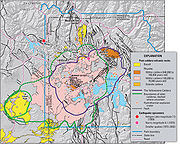
near St. Louis. This supereruption occurred 2.1 million years BP and produced 2500 km3 of ash. The Island Park Caldera is sometimes referred to as the First Phase Yellowstone Caldera or the Huckleberry Ridge Caldera. The youngest of the hotspot calderas, the Yellowstone Caldera, formed 640,000 years ago and is about 34 miles (55 km) by 45 miles (72 km) wide. Non-explosive eruptions of lava and less-violent explosive eruptions have occurred in and near the Yellowstone Caldera since the last supereruption.
The most recent lava flow occurred about 70,000 years ago, while the largest violent eruption excavated the West Thumb of Lake Yellowstone around 150,000 years ago. Smaller steam explosions occur as well - an explosion 13,800 years ago left a 5 kilometer diameter crater at Mary Bay on the edge of Yellowstone Lake. Both Heise and Yellowstone produced a series of normal caldera-forming magmas and a series of light post-caldera magmas. The final stage of volcanism at Heise was marked by light magma eruptions. If Heise is any indication, this could mean that the Yellowstone Caldera has entered its final act, but the volcano could exit with a climactic fourth caldera event analogous to the fourth and final caldera-forming light magma of Heise (the Kilgore Tuff). The appearance of light magmas indicates that the uppermost portion of the continental crust has been consumed, exhausting the melting potential of the crust above the mantle plume. In this case Yellowstone could be expiring. It could be another 1-2 million years before a new supervolcano is born to the northeast, and the Yellowstone Plateau volcanic field joins the ranks of its deceased ancestors in the Snake River Plain.
The Yellowstone hotspot is one of the few volcanic hotspots underlying North America
North America
North America is a continent wholly within the Northern Hemisphere and almost wholly within the Western Hemisphere. It is also considered a northern subcontinent of the Americas...
; others include the Anahim
Anahim hotspot
The Anahim hotspot is a volcanic hotspot in central British Columbia, Canada. It is situated on the Interior Plateau, a large region that lies between the Cariboo and Monashee Mountains to the east, and the Hazelton Mountains, Coast Mountains and Cascade Range to the west...
and Raton hotspot
Raton hotspot
The Raton hotspot is a volcanic hotspot which is responsible for the volcanic activity which forms the volcanoes in northeastern New Mexico, United States....
s.
Eruptive history
- Hell's Half Acre lava fieldHell's Half Acre Lava FieldHell's Half Acre lava field is a basaltic lava plain located on the Snake River Plain of Idaho in the United States. It is the easternmost of the basaltic lava fields on the Snake River Plain, located about west of Idaho Falls, Idaho and north of Pocatello, Idaho. In 1976 the National Park...
, southwestern of Idaho Falls; 3.250 ka ±0.15. (3,250 years ago) - Shoshone lava fieldShoshone lava fieldThe Shoshone lava field is a lava plain in the U.S. state of Idaho, located north of the city of Twin Falls.It is the westernmost of the young lava fields accupying the Snake River Plain. The latest volcanic activity occurred during the Holocene period....
, North of Twin Falls, IdahoTwin Falls, IdahoTwin Falls is the county seat and largest city of Twin Falls County, Idaho, United States. The population was 44,125 at the 2010 censusTwin Falls is the largest city of Idaho's Magic Valley region...
; 8.400 ka ±0.3. - Craters of the Moon National Monument and PreserveCraters of the Moon National Monument and PreserveCraters of the Moon National Monument and Preserve is a national monument and national preserve located in the Snake River Plain in central Idaho, U.S.A. It is along US 20 , between the small cities of Arco and Carey, at an average elevation of above sea level...
; Great Rift of Idaho; the lava field was formed during eight eruptive episodes between about 15 and 2 ka.- Kings Bowl and Wapi lava fields formed about 2.250 ka.
- Yellowstone Caldera; between 70 and 150 ka; 1000 cubic kilometres (239.9 cu mi) intracaldera rhyolitic lava flows.
- Yellowstone Park
- Yellowstone CalderaYellowstone CalderaThe Yellowstone Caldera is the volcanic caldera located in Yellowstone National Park in the United States, sometimes referred to as the Yellowstone Supervolcano. The caldera is located in the northwest corner of Wyoming, in which the vast majority of the park is contained. The major features of...
(size: 45 x 85 km); 640 ka; VEI 8; more than 1000 cubic kilometres (240 cu mi) of Lava Creek TuffLava Creek TuffLava Creek Tuff is a tuff formation, in Wyoming, created when the Yellowstone Caldera erupted about 640,000 years ago.The Lava Creek Tuff distributed in a radial pattern around the caldera and is formed of of ash in pyroclastic flows....
. - Henry's Fork CalderaHenry's Fork CalderaThe Henry's Fork Caldera in Idaho is a caldera located an area known as Island Park west of Yellowstone National Park. The caldera was formed by one of the world's supervolcanos in an eruption of more than 280 cubic kilometers 1.3 million years BP, and is the source of the Mesa Falls Tuff.The...
(size: 16 km wide); 1.3 Ma; VEI 7; 280 cubic kilometres (67.2 cu mi) of Mesa Falls TuffMesa Falls TuffThe Mesa Falls Tuff is a tuff formation created by the Mesa Falls eruption that formed the Henry's Fork Caldera that is located in Idaho west of Yellowstone Park. It is the second most recent caldera forming eruption from the Yellowstone hotspot and ejected of 280 km³ of material...
.- Island Park CalderaIsland Park CalderaThe volcanic feature commonly called the Island Park Caldera in the states of Idaho and Wyoming, U.S., is actually two calderas, one nested inside the other. The Island Park Caldera is the older and much larger caldera, with approximate dimensions of 58 miles by 40 miles...
- Harriman State ParkHarriman State Park (Idaho)Harriman State Park is a state park in eastern Idaho, USA. It is located on an wildlife refuge in the Greater Yellowstone Ecosystem and is home to an abundance of elk, moose, sandhill cranes, trumpeter swans, and the occasional black or grizzly bear. Two-thirds of the trumpeter swans that winter...
- Island Park Caldera
- Island Park CalderaIsland Park CalderaThe volcanic feature commonly called the Island Park Caldera in the states of Idaho and Wyoming, U.S., is actually two calderas, one nested inside the other. The Island Park Caldera is the older and much larger caldera, with approximate dimensions of 58 miles by 40 miles...
(size: 100 x 50 km); 2.1 Ma; VEI 8; 2450 cubic kilometres (588 cu mi) of Huckleberry Ridge TuffHuckleberry Ridge TuffThe Huckleberry Ridge Tuff is a tuff formation created by the Huckleberry Ridge eruption that formed the Island Park Caldera that lies partially in Yellowstone Park, Wyoming and stretches westward into Idaho into a region known as Island Park...
. - Heise volcanic field, Idaho:
- Kilgore Caldera (size: 80 x 60 km); VEI 8; 1800 cubic kilometres (432 cu mi) of Kilgore Tuff; 4.45 Ma ±0.05.
- 4.49 Ma tuff of Heise
- 5.37 Ma tuff of Elkhorn Springs
- 5.51 Ma ±0.13 (Conant Creek Tuff) (but Anders (2009): 5.94 Ma)
- 5.6 Ma; 500 cubic kilometres (120 cu mi) of Blue Creek Tuff.
- 5.81 Ma tuff of Wolverine Creek
- 6.27 Ma ±0.04 (Walcott Tuff).
- 6.57 Ma tuff of Edie School
- Blacktail Caldera (size: 100 x 60 km); 6.62 Ma ±0.03; 1500 cubic kilometres (360 cu mi) of Blacktail Tuff.
- 7.48 Ma tuff of America Falls
- 8.75 Ma tuff of Lost River Sinks
- 9.17 Ma tuff of Kyle Canyon
- 9.34 Ma tuff of Little Chokecherry Canyon
- Twin Falls volcanic field, Twin Falls County, IdahoTwin Falls County, IdahoTwin Falls County is a county in the south central part of the U.S. state of Idaho. As of the 2000 Census, the county had a population of 64,284 . The county seat and largest city is Twin Falls....
; 8.6 to 10 Ma. - Picabo volcanic field, Picabo, IdahoPicabo, IdahoPicabo is an unincorporated community in Blaine County, Idaho, United States. Picabo is located along U.S. Highway 20, about west of Carey, southeast of Hailey, and northeast of Shoshone. It has a gas station, country store, post office, and a small airport. The community is surrounded by...
; 10.09 Ma (Arbon Valley Tuff A) and 10.21 Ma ±0.03 (Arbon Valley Tuff B). - Bruneau-Jarbidge volcanic field, Bruneau RiverBruneau RiverThe Bruneau River is a tributary of the Snake River, in the U.S. states of Idaho and Nevada. It runs through a narrow canyon cut into ancient lava flows in southwestern Idaho...
/ Jarbidge RiverJarbidge RiverThe Jarbidge River is a , high altitude river in northern Nevada and southwest Idaho in the United States. The Jarbidge originates as two main forks in the Jarbidge Mountains of northeastern Nevada and then flows through basalt and rhyolite canyons on the high plateau of the Owyhee Desert before...
, Idaho; 10.0 to 12.5 Ma; Ashfall Fossil BedsAshfall Fossil BedsThe Ashfall Fossil Beds of Antelope County in northeastern Nebraska are among the rare preservation sites called lagerstätten, which preserve ecological "snapshots" from a moment in time, due to extraordinary local conditions that have preserved a range of fossilized organisms undisturbed.The...
eruption. - Owyhee-Humboldt volcanic field, Owyhee County, IdahoOwyhee County, IdahoOwyhee County is a county located in the southwestern corner of the U.S. state of Idaho. In area it is the second largest county in Idaho, behind Idaho County. As of the 2000 Census, Owyhee County had a population of 10,644...
, Nevada, and Oregon; around 12.8 to 13.9 Ma. - McDermitt volcanic field, Orevada rift, McDermitt, Nevada/ Oregon (five overlapping and nested calderas; satellitic to these are two additional calderas), 20000 km² (7,722 sq mi):
- Trout Creek MountainsTrout Creek MountainsThe Trout Creek Mountains are a remote mountain range in southeastern Oregon and northern Nevada, United States. The highest point in the range is Orevada View Benchmark. Most of the Trout Creek Mountains are public lands, administered by the Bureau of Land Management. There is very little human...
, East of the Pueblo MountainsPueblo MountainsThe Pueblo Mountains are a remote mountain range in the United States located in southeastern Oregon and northwestern Nevada. The highest point in the range is Pueblo Mountain. The dominant vegetation throughout the range are grasses and sagebrush; however, there are meadows with cottonwood,...
, Whitehorse Caldera (size: 15 km wide), Oregon; 15 Ma; 40 cubic kilometres (10 cu mi) of Whitehorse Creek Tuff. - Jordan Meadow Caldera, (size: 10–15 km wide); 15.6 Ma; 350 cubic kilometres (84 cu mi) Longridge Tuff member 2-3.
- Longridge Caldera, (size: 33 km wide); 15.6 Ma; 400 cubic kilometres (96 cu mi) Longridge Tuff member 5.
- Calavera Caldera, (size: 17 km wide); 15.7 Ma; 300 cubic kilometres (72 cu mi) of Double H Tuff.
- Trout Creek Mountains, Pueblo Caldera (size: 20 x 10 km), Oregon; 15.8 Ma; 40 cubic kilometres (10 cu mi) of Trout Creek Mountains Tuff.
- Hoppin Peaks Caldera, 16 Ma; Hoppin Peaks Tuff.
- Washburn Caldera, (size: 30 x 25 km wide), Oregon; 16.548 Ma; 250 cubic kilometres (60 cu mi) of Oregon Canyon Tuff.
- Trout Creek Mountains
- Yellowstone hotspot (?), Lake Owyhee volcanic field; 15.0 to 15.5 Ma.
- Yellowstone hotspot (?), Northwest Nevada volcanic field, Virgin Valley, High Rock, Hog Ranch, and unnamed calderas; West of the Pine Forest RangePine Forest RangeThe Pine Forest Range is a mountain range in Humboldt County, Nevada....
, Nevada; 15.5 to 16.5 Ma; Tuffs: Idaho Canyon, Ashdown, Summit Lake, and Soldier Meadow. - Columbia River Basalt Province: Yellowstone hotspot sets off a huge pulse of volcanic activity, the first eruptions were near the Oregon-Idaho-Washington border. Columbia River and Steens flood basalts, Pueblo, and Malheur Gorge-region, Pueblo MountainsPueblo MountainsThe Pueblo Mountains are a remote mountain range in the United States located in southeastern Oregon and northwestern Nevada. The highest point in the range is Pueblo Mountain. The dominant vegetation throughout the range are grasses and sagebrush; however, there are meadows with cottonwood,...
, Steens MountainSteens MountainSteens Mountain is a large fault-block mountain in the southeastern part of the U.S. state of Oregon. Located in Harney County, it stretches some and rises from an elevation of about above the Alvord Desert to its peak at...
, Washington, Oregon, and Idaho, USA; most vigorous eruptions were from 14 to 17 Ma; 180000 cubic kilometres (43,184 cu mi) of lava.- Columbia River flood basaltsColumbia River Basalt GroupThe Columbia River Basalt Group is a large igneous province that lies across parts of the Western United States. It is found in the U.S. states of Washington, Oregon, Idaho, Nevada, and California...
, 175000 cubic kilometres (41,985 cu mi) - Steens flood basalts, 65000 cubic kilometres (15,594 cu mi)
- Columbia River flood basalts
- Crescent volcanics, Olympic PeninsulaOlympic PeninsulaThe Olympic Peninsula is the large arm of land in western Washington state of the USA, that lies across Puget Sound from Seattle. It is bounded on the west by the Pacific Ocean, the north by the Strait of Juan de Fuca, and the east by Puget Sound. Cape Alava, the westernmost point in the contiguous...
/ southern Vancouver IslandVancouver IslandVancouver Island is a large island in British Columbia, Canada. It is one of several North American locations named after George Vancouver, the British Royal Navy officer who explored the Pacific Northwest coast of North America between 1791 and 1794...
, 50-60 Ma.- Siletz River VolcanicsSiletz River VolcanicsThe Siletz River Volcanics is a sequence of basaltic pillow lavas that make up part of the Oregon Coast Range, United States. The basaltic pillow lavas originally came from submarine volcanoes that existed during the Eocene....
, Oregon Coast RangeOregon Coast RangeThe Oregon Coast Range, often called simply the Coast Range and sometimes the Pacific Coast Range, is a mountain range, in the Pacific Coast Ranges physiographic region, in the U.S. state of Oregon along the Pacific Ocean...
, a sequence of basaltBasaltBasalt is a common extrusive volcanic rock. It is usually grey to black and fine-grained due to rapid cooling of lava at the surface of a planet. It may be porphyritic containing larger crystals in a fine matrix, or vesicular, or frothy scoria. Unweathered basalt is black or grey...
ic pillow lavaPillow lavaPillow lavas are lavas that contain characteristic pillow-shaped structures that are attributed to the extrusion of the lava under water, or subaqueous extrusion. Pillow lavas in volcanic rock are characterized by thick sequences of discontinuous pillow-shaped masses, commonly up to one metre in...
s.
- Siletz River Volcanics
- Carmacks GroupCarmacks GroupThe Carmacks Group is a Late Cretaceous volcanic group in southwest-central Yukon, Canada, located between the communities of Dawson City and Whitehorse. It consists of flood basalts, course volcaniclastic rocks and sandy tuffs interbedded with subordinate andesite and basaltic lava flows...
, YukonYukonYukon is the westernmost and smallest of Canada's three federal territories. It was named after the Yukon River. The word Yukon means "Great River" in Gwich’in....
, 63000 square kilometre, 70 Ma.