

Islands of the Forth
Encyclopedia

Firth of Forth
The Firth of Forth is the estuary or firth of Scotland's River Forth, where it flows into the North Sea, between Fife to the north, and West Lothian, the City of Edinburgh and East Lothian to the south...
lie between Fife
Fife
Fife is a council area and former county of Scotland. It is situated between the Firth of Tay and the Firth of Forth, with inland boundaries to Perth and Kinross and Clackmannanshire...
and the Lothian
Lothian
Lothian forms a traditional region of Scotland, lying between the southern shore of the Firth of Forth and the Lammermuir Hills....
s and contain most of the islands. The majority lie east of city of Edinburgh
Edinburgh
Edinburgh is the capital city of Scotland, the second largest city in Scotland, and the eighth most populous in the United Kingdom. The City of Edinburgh Council governs one of Scotland's 32 local government council areas. The council area includes urban Edinburgh and a rural area...
although two are to the west and two more lie in the estuary of the River Forth
River Forth
The River Forth , long, is the major river draining the eastern part of the central belt of Scotland.The Forth rises in Loch Ard in the Trossachs, a mountainous area some west of Stirling...
. The islands have a varied geology and history and several have both ecclesiastical connections and were involved in military occupations throughout the centuries of recorded history. Various lighthouses and other aids to navigation have been erected on the islands and skerries, one dating to the 17th century, but only one of the islands is still permanently inhabited. The area has a diversity of bird and sea life and the scientific name for the Northern Gannet
Northern Gannet
The Northern Gannet is a seabird and is the largest member of the gannet family, Sulidae.- Description :Young birds are dark brown in their first year, and gradually acquire more white in subsequent seasons until they reach maturity after five years.Adults are long, weigh and have a wingspan...
is derived from this bird's connection with the Bass Rock
Bass Rock
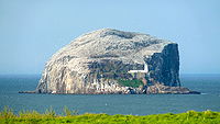
The Bass Rock, or simply The Bass, , is an island in the outer part of the Firth of Forth in the east of Scotland. It is approximately offshore, and north-east of North Berwick. It is a steep-sided volcanic rock, at its highest point, and is home to a large colony of gannets...
.
Most of Scotland's islands are found in the Hebrides
Hebrides
The Hebrides comprise a widespread and diverse archipelago off the west coast of Scotland. There are two main groups: the Inner and Outer Hebrides. These islands have a long history of occupation dating back to the Mesolithic and the culture of the residents has been affected by the successive...
off the west coast and in the Northern Isles
Northern Isles
The Northern Isles is a chain of islands off the north coast of mainland Scotland. The climate is cool and temperate and much influenced by the surrounding seas. There are two main island groups: Shetland and Orkney...
. There are relatively few islands of any size off eastern Scotland, and most of those that are, are in this group.Other east coast islands include Mugdrum in the Firth of Tay
Firth of Tay
The Firth of Tay is a firth in Scotland between the council areas of Fife, Perth and Kinross, the City of Dundee and Angus, into which Scotland's largest river in terms of flow, the River Tay, empties....
and Inchcape
Inchcape
Inchcape or the Bell Rock is a notorious reef off the east coast of Angus, Scotland, near Dundee and Fife . Bell Rock Lighthouse, an automatic lighthouse, occupies the reef...
a notorious reef off the Angus
Angus
Angus is one of the 32 local government council areas of Scotland, a registration county and a lieutenancy area. The council area borders Aberdeenshire, Perth and Kinross and Dundee City...
coast. There are several skerries and small islands further north such as Craiglethy
Craiglethy
Craiglethy is a small island/skerry off Fowlsheugh on the east coast of Aberdeenshire, Scotland in the North Sea. As it is part of Fowlsheugh, it is an SSSI, with many seabirds and seals living on it...
, the Covesea Skerries
Covesea Skerries Lighthouse
Covesea Skerries Lighthouse, belonging to the Northern Lighthouse Board , is built on top of a small headland on the south coast of the Moray Firth at Covesea, near Lossiemouth, Moray, Scotland.-History:...
and Innis Mhòr
Innis Mhòr
Innis Mhòr is a tidal island in the Dornoch Firth of Easter Ross off the east coast of Scotland. It is about in extent and is largely, if not exclusively made up of moving sand dunes. No point on the island is greater than above sea level. It has almost certainly never been permanently inhabited...
. For a full listing see List of outlying islands of Scotland.
Geography
Furthest east is the Isle of MayIsle of May
The Isle of May is located in the north of the outer Firth of Forth, approximately off the coast of mainland Scotland. It is 1.8 km long and less than half a kilometre wide...
, off the coast of Fife south of Crail
Crail
Crail ; ) is a former royal burgh in the East Neuk of Fife, Scotland.-History:Crail probably dates from at least as far back as the Pictish period, as the place-name includes the Pictish/Brythonic element caer, 'fort', and there is a Dark Age cross-slab preserved in the parish kirk, itself...
. To the south in the outer Firth there is a group of islands off East Lothian
East Lothian
East Lothian is one of the 32 council areas of Scotland, and a lieutenancy Area. It borders the City of Edinburgh, Scottish Borders and Midlothian. Its administrative centre is Haddington, although its largest town is Musselburgh....
near North Berwick
North Berwick
The Royal Burgh of North Berwick is a seaside town in East Lothian, Scotland. It is situated on the south shore of the Firth of Forth, approximately 25 miles east of Edinburgh. North Berwick became a fashionable holiday resort in the 19th century because of its two sandy bays, the East Bay and the...
and Gullane
Gullane
Gullane is a town on the southern shore of the Firth of Forth in East Lothian on the east coast of Scotland. There has been a church in the village since the 9th century. The ruins of the Old Church of St...
; from east to west they are the Bass Rock (also known simply as "The Bass"), Craigleith
Craigleith
Craigleith is a small island in the Firth of Forth off North Berwick in East Lothian, Scotland. Its name comes from the Scottish Gaelic Creag Lìte meaning "rock of Leith". It is 24 m at its highest point.-Geography and geology:...
, The Lamb
The Lamb (island)
The Lamb, sometimes called Lamb Island or just Lamb, is a small , uninhabited island between the islands of Fidra and Craigleith in the Firth of Forth, off the south-east coast of Scotland...
, Fidra
Fidra
Fidra is an uninhabited island in the Firth of Forth, north-west of North Berwick, on the east coast of Scotland.-Geography:...
and Eyebroughy
Eyebroughy
Eyebroughy is an islet in the Firth of Forth, 200 m off East Lothian, Scotland. It is not far from Gullane and 3 miles from North Berwick, and forms part of the parish of Dirleton ....
. A second group lie in the inner Firth of Forth. Inchkeith
Inchkeith
Inchkeith is an island in the Firth of Forth, Scotland. It is part of the council area of Fife.Inchkeith has had a colourful history as a result of its proximity to Edinburgh and strategic location for use as home for a lighthouse and for military purposes defending the Firth of Forth for attack...
and Inchcolm
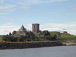
Inchcolm
Inchcolm is an island in the Firth of Forth in Scotland. Repeatedly attacked by English raiders during the Wars of Scottish Independence, it was fortified during both World Wars to defend nearby Edinburgh...
are off Kinghorn
Kinghorn
Kinghorn is a town in Fife, Scotland. A seaside resort with two beaches, Kinghorn Beach and Pettycur Bay, plus a fishing port, it stands on the north shore of the Firth of Forth opposite Edinburgh...
and Aberdour
Aberdour
Aberdour is a scenic and historic village on the south coast of Fife, Scotland. It is on the north shore of the Firth of Forth, looking south to the island of Inchcolm and its Abbey, and to Leith and Edinburgh beyond. According to the 2006 population estimate, the village has a population of...
on the north shore, whilst Inchmickery
Inchmickery
Inchmickery is a small island in the Firth of Forth in Scotland. It is about a mile north of Edinburgh.Its name comes from the Scottish Gaelic, Innis nam Bhiocaire, meaning Isle of the Vicar, implying that there may have been an old ecclesiastical or Culdee settlement here, as in nearby Inchcolm...
, Cramond Island
Cramond Island
Cramond Island is one of several islands that lie in the Firth of Forth in eastern Scotland, near Edinburgh. As its name implies, it lies off Cramond. It is long and covers , and is currently part of the Dalmeny Estate.Strictly speaking it is not a true island at all, but a tidal island being...
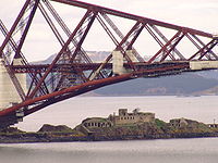
, and Inchgarvie
Inchgarvie
Inchgarvie is a small, uninhabited island in the Firth of Forth. Its name comes from Innis Garbhach which is Scottish Gaelic for "rough island"...
are nearer to Edinburgh
Edinburgh
Edinburgh is the capital city of Scotland, the second largest city in Scotland, and the eighth most populous in the United Kingdom. The City of Edinburgh Council governs one of Scotland's 32 local government council areas. The council area includes urban Edinburgh and a rural area...
and South Queensferry
South Queensferry
South Queensferry , also called Queensferry, is a former Royal Burgh in West Lothian now part of the City of Edinburgh, Scotland. It is located some ten miles to the north west of the city centre, on the shore of the Firth of Forth between the Forth Bridge and the Forth Road Bridge, approximately 8...
on the south shore. Alloa Inch
Alloa Inch
Inch or Alloa Inch is an island in the tidal reaches of the River Forth near Alloa, just before the river opens out into the Firth of Forth....
and Tullibody Inch
Tullibody Inch
Tullibody Inch is an islet in the estuarine waters of the River Forth. It takes its name from the nearby town of Tullibody, "inch" being from the Scottish Gaelic innis meaning "island" or "meadow"....
are furthest west in the estuarine waters of the River Forth.
Only one of these islands, Inchcolm, has a resident population at present, although there have been monasteries, hermitages, lighthouses and fortifications on most of them in the past. In the late 19th century the Isle of May had a population of over 20. Many of the island names have the first element, "Inch-" (from Innis, the Gaelic
Scottish Gaelic language
Scottish Gaelic is a Celtic language native to Scotland. A member of the Goidelic branch of the Celtic languages, Scottish Gaelic, like Modern Irish and Manx, developed out of Middle Irish, and thus descends ultimately from Primitive Irish....
word for "island").Innis also means "meadow".
Because of their proximity to Edinburgh, smaller towns such as Dalgety Bay
Dalgety Bay
Dalgety Bay Today, Dalgety Bay functions largely as a dormitory suburb of Edinburgh and to the rest of Fife. While the architecture of the town reflects construction by volume housebuilders, the town is a regular winner of the Best Kept Small Town title...
and Kirkcaldy
Kirkcaldy
Kirkcaldy is a town and former royal burgh in Fife, on the east coast of Scotland. The town lies on a shallow bay on the northern shore of the Firth of Forth; SSE of Glenrothes, ENE of Dunfermline, WSW of Dundee and NNE of Edinburgh...
, and the Forth Bridges, the islands form a well-known part of the scenery of the Firth for many thousands of people.
Geology
Geologically, most of the islands are the remnants of igneous intrusions. The Isle of May's rock is "fine grained basaltBasalt
Basalt is a common extrusive volcanic rock. It is usually grey to black and fine-grained due to rapid cooling of lava at the surface of a planet. It may be porphyritic containing larger crystals in a fine matrix, or vesicular, or frothy scoria. Unweathered basalt is black or grey...
of a dark-grey colour with tinges of green and greenstone
Greenschist
Greenschist is a general field petrologic term applied to metamorphic or altered mafic volcanic rock. The term greenstone is sometimes used to refer to greenschist but can refer to other rock types too. The green is due to abundant green chlorite, actinolite and epidote minerals that dominate the...
". Fidra is also largely basalt and The Bass is a phonolite
Phonolite
Phonolite is a rare igneous, volcanic rock of intermediate composition, with aphanitic to porphyritic texture....
volcanic plug
Volcanic plug
A volcanic plug, also called a volcanic neck or lava neck, is a volcanic landform created when magma hardens within a vent on an active volcano. When forming, a plug can cause an extreme build-up of pressure if volatile-charged magma is trapped beneath it, and this can sometimes lead to an...
. Craigleith is a laccolith
Laccolith
A laccolith is a sheet intrusion that has been injected between two layers of sedimentary rock. The pressure of the magma is high enough that the overlying strata are forced upward, giving the laccolith a dome or mushroom-like form with a generally planar base.Laccoliths tend to form at relatively...
made up of essexite
Essexite
Essexite , also called nepheline monzogabbro , is a dark gray or black holocrystalline plutonic igneous rock. Its name is derived from the type locality in Essex County, MA.Modern petrology identifies rocks according to mineralogical criteria...
which is popular for making curling
Curling
Curling is a sport in which players slide stones across a sheet of ice towards a target area. It is related to bowls, boule and shuffleboard. Two teams, each of four players, take turns sliding heavy, polished granite stones, also called "rocks", across the ice curling sheet towards the house, a...
stones and Cramond island is made up of dolerite
Diabase
Diabase or dolerite is a mafic, holocrystalline, subvolcanic rock equivalent to volcanic basalt or plutonic gabbro. In North American usage, the term diabase refers to the fresh rock, whilst elsewhere the term dolerite is used for the fresh rock and diabase refers to altered material...
. Inchmickery and Inchgarvie are of igneous origin and the latter is partly made up of picrite. Studies of the landscape beneath the waters of the firth have revealed that the visible surface of Inchgarvie is only the top of a larger crag and tail
Crag and tail
A crag is a rocky hill or mountain, generally isolated from other high ground. Crags are formed when a glacier or ice sheet passes over an area that contains a particularly resistant rock formation...
structure similar in structure to Edinburgh Castle
Edinburgh Castle
Edinburgh Castle is a fortress which dominates the skyline of the city of Edinburgh, Scotland, from its position atop the volcanic Castle Rock. Human habitation of the site is dated back as far as the 9th century BC, although the nature of early settlement is unclear...
and the Royal Mile
Royal Mile
The Royal Mile is a succession of streets which form the main thoroughfare of the Old Town of the city of Edinburgh in Scotland.As the name suggests, the Royal Mile is approximately one Scots mile long, and runs between two foci of history in Scotland, from Edinburgh Castle at the top of the Castle...
created by glacial
Glacier
A glacier is a large persistent body of ice that forms where the accumulation of snow exceeds its ablation over many years, often centuries. At least 0.1 km² in area and 50 m thick, but often much larger, a glacier slowly deforms and flows due to stresses induced by its weight...
action. The tidal islet of Eyebroughy is about 1.5 kilometre (0.93205910497471 mi) to the west of Fidra. Its component rock is trachyte
Trachyte
Trachyte is an igneous volcanic rock with an aphanitic to porphyritic texture. The mineral assemblage consists of essential alkali feldspar; relatively minor plagioclase and quartz or a feldspathoid such as nepheline may also be present....
and Lower Carboniferous in origin.
Most of Inchkeith is of volcanic origin but there are also sections of sandstone
Sandstone
Sandstone is a sedimentary rock composed mainly of sand-sized minerals or rock grains.Most sandstone is composed of quartz and/or feldspar because these are the most common minerals in the Earth's crust. Like sand, sandstone may be any colour, but the most common colours are tan, brown, yellow,...
, coal
Coal
Coal is a combustible black or brownish-black sedimentary rock usually occurring in rock strata in layers or veins called coal beds or coal seams. The harder forms, such as anthracite coal, can be regarded as metamorphic rock because of later exposure to elevated temperature and pressure...
, limestone
Limestone
Limestone is a sedimentary rock composed largely of the minerals calcite and aragonite, which are different crystal forms of calcium carbonate . Many limestones are composed from skeletal fragments of marine organisms such as coral or foraminifera....
and shale
Shale
Shale is a fine-grained, clastic sedimentary rock composed of mud that is a mix of flakes of clay minerals and tiny fragments of other minerals, especially quartz and calcite. The ratio of clay to other minerals is variable. Shale is characterized by breaks along thin laminae or parallel layering...
, the last named containing numerous fossils. There are also several springs on the island. Inchcolm is similarly varied, consisting of greenstone, sandstone, shale and limestone.
Natural history
The Firth is an important area for nature conservation and has a range of habitats including extensive mudflats, shingle shorelines and saltmarsh. The last named, which is well developed on Alloa Inch, is typically dominated by Saltmarsh RushJuncus gerardii
Juncus gerardii, commonly known as blackgrass, black needle rush or saltmarsh rush, is a member of the family Juncaceae.-Site:...
, Sea Club-rush
Scirpus
The plant genus Scirpus consists of a large number of aquatic, grass-like species in the family Cyperaceae , many with the common names club-rush or bulrush . Other common names are deergrass or grassweed.The genus has a cosmopolitan distribution, and grows in wetlands and moist soil...
, Sea Aster
Aster tripolium
Aster tripolium is a plant of northern Europe that is confined in its distribution to salt marshes, estuaries and occasionally to inland salt works....
and Common Saltmarsh-grass
Puccinellia maritima
Puccinellia maritima is a species of grass known by the common names including seaside alkali grass, common saltmarsh-grass or sea poa grass. It is native to Western Europe and it is present in most of North East North America. It grows in moist, usually saline soils. It can reach a height of...
. The inner Firth is important for nationally and internationally important numbers of wintering wildfowl and wading birds and hosts populations of Shelduck
Shelduck
The shelducks, genus Tadorna, are a group of large birds in the Tadorninae subfamily of the Anatidae, the biological family that includes the ducks and most duck-like waterfowl such as the geese and swans....
, Knot
Red Knot
The Red Knot, Calidris canutus , is a medium sized shorebird which breeds in tundra and the Arctic Cordillera in the far north of Canada, Europe, and Russia. It is a large member of the Calidris sandpipers, second only to the Great Knot...
, Redshank
Common Redshank
The Common Redshank or simply Redshank is an Eurasian wader in the large family Scolopacidae.- Description and systematics :...
, Great Crested Grebe
Great Crested Grebe
The Great Crested Grebe is a member of the grebe family of water birds.- Description :The Great Crested Grebe is long with a wingspan. It is an excellent swimmer and diver, and pursues its fish prey underwater. The adults are unmistakable in summer with head and neck decorations...
, Teal
Teal
Teal may mean:* Teal , a medium greenish-blue color* Various ducks:** Baikal Teal, Anas formosa** Black Teal, Aythya novaeseelandiae** Blue-winged Teal, Anas discors** Brown Teal, Anas aucklandica** Campbell Teal Anas nesiotis...
and Goldeneye
GoldenEye
GoldenEye is the seventeenth spy film in the James Bond series, and the first to star Pierce Brosnan as the fictional MI6 agent James Bond. The film was directed by Martin Campbell and is the first film in the series not to take story elements from the works of novelist Ian Fleming...
. The outer islands support significant numbers of nesting seabirds. The Bass Rock has more than 150,000 nesting Northern Gannets and is the largest single rock gannetry in the world. When viewed from the mainland much of the rock looks white due to the sheer number of birds (and their droppings, which give off 152 tonnes of ammonia
Ammonia
Ammonia is a compound of nitrogen and hydrogen with the formula . It is a colourless gas with a characteristic pungent odour. Ammonia contributes significantly to the nutritional needs of terrestrial organisms by serving as a precursor to food and fertilizers. Ammonia, either directly or...
per year). The scientific names for this Gannet, Sula bassana and Morus bassanus, are derived from the rock. The bird was traditionally known locally as the Solan Goose, and its eggs and meat were considered delicacies. It is estimated that in 1850 almost 2000 birds were harvested from the rock. Other bird species on the rock include Guillemot
Common Guillemot
The Common Murre or Common Guillemot is a large auk. It is also known as the Thin-billed Murre in North America. It has a circumpolar distribution, occurring in low-Arctic and boreal waters in the North-Atlantic and North Pacific...
, Razorbill
Razorbill
The Razorbill is colonial seabird that will only come to land in order to breed. It is the largest living member of the Auk family. This agile bird will choose only one partner for life and females will lay one egg per year. Razorbills will nest along coastal cliffs in enclosed or slightly exposed...
, Cormorant
Great Cormorant
The Great Cormorant , known as the Great Black Cormorant across the Northern Hemisphere, the Black Cormorant in Australia and the Black Shag further south in New Zealand, is a widespread member of the cormorant family of seabirds...
, Puffin
Atlantic Puffin
The Atlantic Puffin is a seabird species in the auk family. It is a pelagic bird that feeds primarily by diving for fish, but also eats other sea creatures, such as squid and crustaceans. Its most obvious characteristic during the breeding season is its brightly coloured bill...
, Eider Duck
Common Eider
The Common Eider, Somateria mollissima, is a large sea-duck that is distributed over the northern coasts of Europe, North America and eastern Siberia. It breeds in Arctic and some northern temperate regions, but winters somewhat farther south in temperate zones, when it can form large flocks on...
and numerous gulls.

Rabbit
Rabbits are small mammals in the family Leporidae of the order Lagomorpha, found in several parts of the world...
warren. The rabbits were bred for food but they were wiped out by myxomatosis
Myxomatosis
Myxomatosis is a disease that affects rabbits and is caused by the Myxoma virus. It was first observed in Uruguay in laboratory rabbits in the late 19th century. It was introduced into Australia in 1950 in an attempt to control the rabbit population...
in the 1950s. The Atlantic Puffin
Atlantic Puffin
The Atlantic Puffin is a seabird species in the auk family. It is a pelagic bird that feeds primarily by diving for fish, but also eats other sea creatures, such as squid and crustaceans. Its most obvious characteristic during the breeding season is its brightly coloured bill...
colony on Craigleith, once one of the largest in Britain with 28,000 pairs, became endangered from 1999 onwards, due to an invasion of the non-endemic plant tree mallow, which choked the puffins' burrows, preventing them from rearing their chicks, or "pufflings". A five year project, SOS Puffin, led by the Scottish Seabird Centre at North Berwick, was launched early in 2007. Since then, hundreds of volunteers have been working hard to rid the island of the problem, ferried out by boat from the Seabird Centre during the winter months, when the puffins are at sea. There are signs that the puffins are starting to return to the island to breed. Findra, Inchmickery and Eyebroughy are RSPB
Royal Society for the Protection of Birds
Bird Notes and News was first published in April 1903.The title changed to 'Bird Notes' in 1947. In the 1950s, there were four copies per year . Each volume covered two years, spread over three calendar years...
reserves, the last named being noted for its Cormorants. Over 240 species of bird and 60 varieties of seaweed have been recorded on the Isle of May.
History
Several of the islands contain pre-historic remains created by cultures whose names are unknown. They have also been affected by the successive influences of Celtic, Norse and EnglishEnglish language
English is a West Germanic language that arose in the Anglo-Saxon kingdoms of England and spread into what was to become south-east Scotland under the influence of the Anglian medieval kingdom of Northumbria...
-speaking peoples during the historic period and this is reflected in their names. The islands also came under attack from Vikings during the early Historic period.
15th century
During the reign of King James IVJames IV of Scotland
James IV was King of Scots from 11 June 1488 to his death. He is generally regarded as the most successful of the Stewart monarchs of Scotland, but his reign ended with the disastrous defeat at the Battle of Flodden Field, where he became the last monarch from not only Scotland, but also from all...
Inchkeith was the site of an extraordinary experiment. According to the historian Robert Lyndsay of Pitscottie, in 1493 James directed that a dumb
Muteness
Muteness or mutism is an inability to speak caused by a speech disorder. The term originates from the Latin word mutus, meaning "silent".-Causes:...
woman and two infants be transported to the island, to ascertain which language the infants would grow up to speak when isolated from the rest of the world. It was thought that this would be the "original" language, or language of God. There is no reliable account of how the infants spoke although Lyndsay of Pitscottie reported that "some say they spoke good Hebrew".
In 1497 Inchkeith and Inchgarvie were used as an isolated refuge for victims of syphilis
Syphilis
Syphilis is a sexually transmitted infection caused by the spirochete bacterium Treponema pallidum subspecies pallidum. The primary route of transmission is through sexual contact; however, it may also be transmitted from mother to fetus during pregnancy or at birth, resulting in congenital syphilis...
and in 1589, history repeated itself when Inchekith was used to quarantine the passengers of a plague-ridden ship. (More plague sufferers came from the mainland in 1609 and in 1799, Russian sailors who died of an infectious disease were buried there.)
Inchcolm is mentioned in Shakespeare's
William Shakespeare
William Shakespeare was an English poet and playwright, widely regarded as the greatest writer in the English language and the world's pre-eminent dramatist. He is often called England's national poet and the "Bard of Avon"...
Macbeth
Macbeth
The Tragedy of Macbeth is a play by William Shakespeare about a regicide and its aftermath. It is Shakespeare's shortest tragedy and is believed to have been written sometime between 1603 and 1607...
where it is described as "Saint Colmes ynch".
English garrisons
Inchcolm was raided by English troops during the 14th century Wars of IndependenceWars of Scottish Independence
The Wars of Scottish Independence were a series of military campaigns fought between the independent Kingdom of Scotland and the Kingdom of England in the late 13th and early 14th centuries....
. In the 16th century Inchkeith, Inchcolm and Inchgarvie all suffered English occupation. The Earl of Somerset
Edward Seymour, 1st Duke of Somerset
Edward Seymour, 1st Duke of Somerset, 1st Earl of Hertford, 1st Viscount Beauchamp of Hache, KG, Earl Marshal was Lord Protector of England in the period between the death of Henry VIII in 1547 and his own indictment in 1549....
garrisoned the islands in 1547 after the Battle of Pinkie Cleugh
Battle of Pinkie Cleugh
The Battle of Pinkie Cleugh, on the banks of the River Esk near Musselburgh, Scotland on 10 September 1547, was part of the War of the Rough Wooing. It was the last pitched battle between Scottish and English armies, and is seen as the first modern battle in the British Isles...
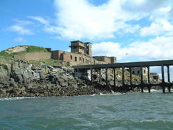
. His force of marines were ordered to reinforce Inchkeith, and they built a large square fort, with corner towers, on the site of the present day lighthouse. His forces, mainly Italian mercenaries, were ejected by a combined Franco-Scottish force under General D’ Essé in 1549.
Later fortifications
World war
A world war is a war affecting the majority of the world's most powerful and populous nations. World wars span multiple countries on multiple continents, with battles fought in multiple theaters....
s. Inchmickery was used as a gun emplacement during both World Wars and the derelict concrete structures were designed to make the island look like a battleship from a distance. These buildings were later used for filming scenes of the film Complicity
Complicity (film)
Complicity is a 2000 film based on the novel Complicity by Iain Banks. The screenplay was written by Bryan Elsley. It was directed by Gavin Millar...
.
Ecclesiastical associations
Culdee
Céli Dé or Culdees were originally members of ascetic Christian monastic and eremitical communities of Ireland, Scotland and England in the Middle Ages. The term is used of St. John the Apostle, of a missioner from abroad recorded in the Annals of the Four Masters at the year 806, and of Óengus...
connections, and had chapels on them. Various saints also have connections with the islands. St Thaney or Thenaw was reputedly the mother of St Kentigern and is said to have been cast adrift in an oarless coracle in deep waters beyond the Isle of May by her father King Leudonus
King Lot
Lot or Loth is the eponymous king of Lothian in the Arthurian legend. He is best known as the father of Sir Gawain. Such a ruler evidently first appeared in hagiographical material concerning Saint Kentigern , which feature a Leudonus, king of Leudonia, a Latin name for Lothian...
, which resulted in an abundance of fish in the seas nearby. St Adrian of May was murdered there by invading Danes in 870 (who killed St Monance in the same raid). He was buried in a stone coffin on the island but is said to have floated across the Firth before coming to rest in a churchyard at Anstruther
Anstruther
Anstruther is a small town in Fife, Scotland. The two halves of Anstruther are divided by a small stream called Dreel Burn. Anstruther lies 9 miles south-southeast of St Andrews. It is the largest community on the stretch of north-shore coastline of the Firth of Forth known as the East Neuk,...
. The Isle of May has a long history of ecclesiastical activity and there are various remains including that of a 13th century Benedictine
Benedictine
Benedictine refers to the spirituality and consecrated life in accordance with the Rule of St Benedict, written by Benedict of Nursia in the sixth century for the cenobitic communities he founded in central Italy. The most notable of these is Monte Cassino, the first monastery founded by Benedict...
church.
The Irish missionary Saint Baldred of Tyninghame
Baldred of Tyninghame
Balthere of Tyninghame was a Northumbrian hermit and abbot, resident in East Lothian during the 8th century.-Dating:According to Hovendeus the date of Baldred's death is given as 756. Symeon of Durham says "the twentieth year of King Eadberht of Northumbria " and Turgot of Durham "the...
resided on The Bass in the 8th century and there is a ruined 12th century chapel on Fidra dedicated to St Nicholas
Saint Nicholas
Saint Nicholas , also called Nikolaos of Myra, was a historic 4th-century saint and Greek Bishop of Myra . Because of the many miracles attributed to his intercession, he is also known as Nikolaos the Wonderworker...
. Inchcolm has connections to St Columba
Columba
Saint Columba —also known as Colum Cille , Colm Cille , Calum Cille and Kolban or Kolbjørn —was a Gaelic Irish missionary monk who propagated Christianity among the Picts during the Early Medieval Period...
and King Alexander I
Alexander I of Scotland
Alexander I , also called Alaxandair mac Maíl Coluim and nicknamed "The Fierce", was King of the Scots from 1107 to his death.-Life:...
was marooned on the island, and decided to make it the site of an Augustinian monastery
Monastery
Monastery denotes the building, or complex of buildings, that houses a room reserved for prayer as well as the domestic quarters and workplace of monastics, whether monks or nuns, and whether living in community or alone .Monasteries may vary greatly in size – a small dwelling accommodating only...
. In the 7th century St Adomnán of Iona founded a "school of the prophets" on Inchkeith in the late 7th century having met St Serf there. Inchmickery's name may be derived from the Gaelic for "island of the vicar".
Navigation
Many of the isles act as an aid to navigation. There are various lighthouseLighthouse
A lighthouse is a tower, building, or other type of structure designed to emit light from a system of lamps and lenses or, in older times, from a fire, and used as an aid to navigation for maritime pilots at sea or on inland waterways....
s and numerous devices to guide shipping in the busy waters near the ports of Leith
Leith
-South Leith v. North Leith:Up until the late 16th century Leith , comprised two separate towns on either side of the river....
and Rosyth
Rosyth
Rosyth is a town located on the Firth of Forth, three miles south of the centre of Dunfermline. According to an estimate taken in 2008, the town has a population of 12,790....
.
In 1803, construction was begun of Inchkeith Lighthouse, designed and built by Thomas Smith
Thomas Smith (engineer)
Thomas Smith was a Scottish businessman and early lighthouse engineer. Born in Broughty Ferry, Dundee, his father drowned in Dundee harbour when he was young...
and Robert Stevenson
Robert Stevenson (civil engineer)
Robert Stevenson FRSE MInstCE FSAS MWS FGS FRAS FSA was a Scottish civil engineer and famed designer and builder of lighthouses.One of his finest achievements was the construction of the Bell Rock Lighthouse.-Early life:...
. The lighthouse stands 67 metres high and was operational by 1804. The Fidra light was built in 1885 and automated in 1970.
The light on the small rock of Oxcars was automated as early as 1894. At that time it was controlled by a clockwork timer and was powered using gas delivered weekly from Granton
Granton, Edinburgh
Granton is a district in the north of Edinburgh, Scotland. Granton forms part of Edinburgh's waterfront along the Firth of Forth and is, historically, an industrial area having a large harbour. Granton is part of Edinburgh's large scale waterfront regeneration programme.-Name:Granton first appears...
gasworks. A lighthouse was constructed on the Bass Rock in 1902.
The Isle of May light has a long history having been in operation since 1635 when a crude coal-fired structure was erected. The existing building was constructed in 1816, which was converted to a "rock station" in 1972 and automated in March 1989. The island is owned by the Commissioners of the Northern Lights
Northern Lighthouse Board
The Northern Lighthouse Board is the General Lighthouse Authority for Scotland and the Isle of Man. It is a non-departmental public body responsible for marine navigation aids around coastal areas.-History:...
although managed by Scottish Natural Heritage
Scottish Natural Heritage
Scottish Natural Heritage is a Scottish public body. It is responsible for Scotland's natural heritage, especially its natural, genetic and scenic diversity. It advises the Scottish Government and acts as a government agent in the delivery of conservation designations, i.e...
as a National Nature Reserve
National Nature Reserves in Scotland
National Nature Reserves in Scotland are established by Scottish Natural Heritage. Until 2004 there were 73 National Nature Reserves in Scotland, as per the list below...
.
None of the islands are accessible by public transport except Inchcolm, which has a regular summer service.
Islands
| Island | Gaelic Name | Meaning of name | Location | Area (ha Hectare The hectare is a metric unit of area defined as 10,000 square metres , and primarily used in the measurement of land. In 1795, when the metric system was introduced, the are was defined as being 100 square metres and the hectare was thus 100 ares or 1/100 km2... ) |
Highest point | Last inhabited |
|---|---|---|---|---|---|---|
| Alloa Inch Alloa Inch Inch or Alloa Inch is an island in the tidal reaches of the River Forth near Alloa, just before the river opens out into the Firth of Forth.... |
Unknown | Alloa Alloa Alloa is a town and former burgh in Clackmannanshire, set in the Central Lowlands of Scotland. It lies on on the north bank of the Firth of Forth close to the foot of the Ochil Hills, east of Stirling and north of Falkirk.... island |
33 c. 33 | <5 | ||
| Bass Rock Bass Rock The Bass Rock, or simply The Bass, , is an island in the outer part of the Firth of Forth in the east of Scotland. It is approximately offshore, and north-east of North Berwick. It is a steep-sided volcanic rock, at its highest point, and is home to a large colony of gannets... |
Unknown | Possibly from Gaelic bathais, meaning "forehead". | 107 | |||
| Craigleith Craigleith Craigleith is a small island in the Firth of Forth off North Berwick in East Lothian, Scotland. Its name comes from the Scottish Gaelic Creag Lìte meaning "rock of Leith". It is 24 m at its highest point.-Geography and geology:... |
Creag Lìte | Rock of Leith | 5 | 24 | ||
| Cramond Island Cramond Island Cramond Island is one of several islands that lie in the Firth of Forth in eastern Scotland, near Edinburgh. As its name implies, it lies off Cramond. It is long and covers , and is currently part of the Dalmeny Estate.Strictly speaking it is not a true island at all, but a tidal island being... |
Unknown | island of the fort on the Almond riverMac an Tàilleir (2003) provides no name for the island itself but states that "Cramond Cramond Cramond is a seaside village now part of suburban Edinburgh, Scotland, located in the north-west corner of the city at the mouth of the River Almond where it enters the Firth of Forth.... " is from the Brythonic Brythonic languages The Brythonic or Brittonic languages form one of the two branches of the Insular Celtic language family, the other being Goidelic. The name Brythonic was derived by Welsh Celticist John Rhys from the Welsh word Brython, meaning an indigenous Briton as opposed to an Anglo-Saxon or Gael... Caramond meaning "fort on the Almond". |
28 | |||
| Fidra Fidra Fidra is an uninhabited island in the Firth of Forth, north-west of North Berwick, on the east coast of Scotland.-Geography:... |
Unknown | From the Norse for "feather island" | 10 | 20 | 1970 | |
| Inchcolm Inchcolm Inchcolm is an island in the Firth of Forth in Scotland. Repeatedly attacked by English raiders during the Wars of Scottish Independence, it was fortified during both World Wars to defend nearby Edinburgh... |
Innis Choluim | Calum/Malcolm or Columba Columba Saint Columba —also known as Colum Cille , Colm Cille , Calum Cille and Kolban or Kolbjørn —was a Gaelic Irish missionary monk who propagated Christianity among the Picts during the Early Medieval Period... 's island |
9 | 34 | ||
| Inchgarvie Inchgarvie Inchgarvie is a small, uninhabited island in the Firth of Forth. Its name comes from Innis Garbhach which is Scottish Gaelic for "rough island"... |
Innis Garbhach | rough island | 19 | |||
| Inchkeith Inchkeith Inchkeith is an island in the Firth of Forth, Scotland. It is part of the council area of Fife.Inchkeith has had a colourful history as a result of its proximity to Edinburgh and strategic location for use as home for a lighthouse and for military purposes defending the Firth of Forth for attack... |
Possibly Innis Cheith or Innis Coit.Recorded as "Insula Keth" in the 12th century Life of Saint Serf. Mac an Tàilleir (2003) and Watson (1926) suggest that the root is the Brthyonic "coed". The derivation would appear to be assumed rather than attested and the modern form is Innis Cheith. | wooded island | 20 | 59 | 1986 | |
| Inchmickery Inchmickery Inchmickery is a small island in the Firth of Forth in Scotland. It is about a mile north of Edinburgh.Its name comes from the Scottish Gaelic, Innis nam Bhiocaire, meaning Isle of the Vicar, implying that there may have been an old ecclesiastical or Culdee settlement here, as in nearby Inchcolm... |
Possibly Innis nam Bhiocaire | Possibly "island of the vicar" | 4 <5 | 14 | ||
| The Lamb The Lamb (island) The Lamb, sometimes called Lamb Island or just Lamb, is a small , uninhabited island between the islands of Fidra and Craigleith in the Firth of Forth, off the south-east coast of Scotland... |
Unknown | From a common Norse name for a small island | 15 | |||
| Isle of May Isle of May The Isle of May is located in the north of the outer Firth of Forth, approximately off the coast of mainland Scotland. It is 1.8 km long and less than half a kilometre wide... |
Eilean Mhàigh | Possibly "gull island" | 45 | 50 | 1989 | |
| Tullibody Inch Tullibody Inch Tullibody Inch is an islet in the estuarine waters of the River Forth. It takes its name from the nearby town of Tullibody, "inch" being from the Scottish Gaelic innis meaning "island" or "meadow".... |
Unknown | Tullibody Tullibody Tullibody is a town set in the Central Lowlands of Scotland. It lies north of the River Forth near to the foot of the Ochil Hills within the Forth Valley. The town is south-west of Alva, north-west of Alloa and east-northeast of Stirling... island |
6 | <5 |
Outer islands
The Isle of May is in the north of the outer Firth of Forth, about 8 kilometres (5 mi) off the coast of mainland Fife. It is 1.8 km long, less than 0.5 km wide and has a total area of 45 hectares (111.2 acre) making it by far the largest of the Forth islands. Although often inhabited in the past nobody has been recorded as living there since the automation of the lighthouse. Rona is a tidal islet to the north joined to the main island by a bridge. Further north are North Ness, the Mars Rocks and Norman Rock. Clett and the Middens are stacksStack (geology)
A stack is a geological landform consisting of a steep and often vertical column or columns of rock in the sea near a coast, isolated by erosion. Stacks are formed through processes of coastal geomorphology, which are entirely natural. Time, wind and water are the only factors involved in the...
to the east and The Pillow is a skerry
Skerry
A skerry is a small rocky island, usually defined to be too small for habitation. It may simply be a rocky reef. A skerry can also be called a low sea stack....
to the south east. Maiden Rocks and Maiden Hair lie just offshore to the south.
The Bass Rock is about 2 kilometres (1.2 mi) offshore, and 5 kilometres (3.1 mi) north-east of North Berwick
North Berwick
The Royal Burgh of North Berwick is a seaside town in East Lothian, Scotland. It is situated on the south shore of the Firth of Forth, approximately 25 miles east of Edinburgh. North Berwick became a fashionable holiday resort in the 19th century because of its two sandy bays, the East Bay and the...
. This steep-sided island is currently uninhabited, but was lived on for many centuries. It has a castle dating from the 14th century, which was later used as a prison and there are the remains of a chapel built circa 1491. The Lauder family owned the island for almost six centuries, and it now belongs to Sir Hew Dalrymple whose family purchased it in 1701. The rock features in various works of fiction, including Robert Louis Stevenson
Robert Louis Stevenson
Robert Louis Balfour Stevenson was a Scottish novelist, poet, essayist and travel writer. His best-known books include Treasure Island, Kidnapped, and Strange Case of Dr Jekyll and Mr Hyde....
's Catriona. At 7.5 hectares (18.5 acre) in extent the Bass Rock is the second largest of the islands of the Forth. The Middens is a small stack that lies just offshore to the northwest.
Craigleith lies north of North Berwick harbour. It was also purchased by Sir Hew Dalrymple, from North Berwick Town Council in 1814.

Uri Geller
Uri Geller is a self-proclaimed psychic known for his trademark television performances of spoon bending and other supposed psychic effects. Throughout the years, Geller has been accused of using simple conjuring tricks to achieve the effects of psychokinesis and telepathy...
for £30,000.
Fidra, archaically Fetheray, is 4 kilometres (2.5 mi) north-west of North Berwick. Like the nearby islands it is the result of volcanic activity and has a substantial seabird population. It can be accessed via a primitive jetty on the eastern shore. It is said that R. L. Stevenson based his map of Treasure Island
Treasure Island
Treasure Island is an adventure novel by Scottish author Robert Louis Stevenson, narrating a tale of "pirates and buried gold". First published as a book on May 23, 1883, it was originally serialized in the children's magazine Young Folks between 1881–82 under the title Treasure Island; or, the...
on the shape of Fidra. The island is also attended by companion islets called North Dog and South Dog and Castle Tarbet is another islet to the south separated from the main bulk at high tides.
Inner islands
Inchkeith is close to the shores of Fife. Its history has been dominated by religion, its use as a quarantine and military events (see above). It is currently owned by Tom FarmerTom Farmer
Sir Thomas "Tom" Farmer, CVO, CBE, KCSG, FRSE, DL is a Scottish entrepreneur.One of seven siblings in a devoutly Catholic family, in 1964 Farmer founded his own tyre retailing business which he sold in 1969 for £450,000. Farmer "retired" to the United States, but became bored and decided to find a...
, founder of Kwikfit, although he doesn't live there.
Inchmickery lies about 8 kilometres (5 mi) east of Inchkeith and it is about 3.5 kilometres (2.2 mi) north of the city of Edinburgh. It is only about 100 metres by 200 metres in size. Rocks known as the Cow and Calf lie to the north and beyond that, about half way to Inchcolm, are the Oxcars, a hazard identified by a permanent light.
Historic Scotland
Historic Scotland is an executive agency of the Scottish Government, responsible for historic monuments in Scotland.-Role:As its website states:...
who maintain the island and run the shop. In the 14th century John of Fordun
John of Fordun
John of Fordun was a Scottish chronicler. It is generally stated that he was born at Fordoun, Mearns. It is certain that he was a secular priest, and that he composed his history in the latter part of the 14th century; and it is probable that he was a chaplain in the St Machar's Cathedral of...
records the name as "Euomonia" (referring to the monasterium Sancti Columbe in insula Euomonia). There are various skerries in the sea to the north including Swallow Craig, Car Craig, Meadulse and Craigdimas.
Inchgarvie's name is from Innis Gharbhaidh which is Scottish Gaelic for "rough island" or possibly "Garbhach's island". This island also has a long history of fortification, but it is now incorporated into the Forth Bridge
Forth Bridge (railway)
The Forth Bridge is a cantilever railway bridge over the Firth of Forth in the east of Scotland, to the east of the Forth Road Bridge, and 14 kilometres west of central Edinburgh. It was opened on 4 March 1890, and spans a total length of...
. In 1878, foundations for Thomas Bouch
Thomas Bouch
Sir Thomas Bouch was a British railway engineer in Victorian Britain.He was born in Thursby, near Carlisle, Cumberland, England and lived in Edinburgh. He helped develop the caisson and the roll-on/roll-off train ferry. He worked initially for the North British Railway and helped design parts of...
's Forth Bridge were laid on Inchgarvie, but after the Tay Bridge Disaster
Tay Bridge disaster
The Tay Bridge disaster occurred on 28 December 1879, when the first Tay Rail Bridge, which crossed the Firth of Tay between Dundee and Wormit in Scotland, collapsed during a violent storm while a train was passing over it. The bridge was designed by the noted railway engineer Sir Thomas Bouch,...
, these plans were abandoned, and the island languished until the west end of the island was extended with a pier, and used as the foundation for one of the Forth Railway Bridge
Forth Bridge (railway)
The Forth Bridge is a cantilever railway bridge over the Firth of Forth in the east of Scotland, to the east of the Forth Road Bridge, and 14 kilometres west of central Edinburgh. It was opened on 4 March 1890, and spans a total length of...
's cantilever
Cantilever
A cantilever is a beam anchored at only one end. The beam carries the load to the support where it is resisted by moment and shear stress. Cantilever construction allows for overhanging structures without external bracing. Cantilevers can also be constructed with trusses or slabs.This is in...
s. Due to its proximity, the island was also used for a construction office for the bridge, as well as accommodation for its workers within the re-roofed castle buildings. Some of the stone from the former castle was used to build the caisson
Caisson (engineering)
In geotechnical engineering, a caisson is a retaining, watertight structure used, for example, to work on the foundations of a bridge pier, for the construction of a concrete dam, or for the repair of ships. These are constructed such that the water can be pumped out, keeping the working...
s of the Forth Bridge.
Cramond Island in the Almond estuary
River Almond, Lothian
The River Almond is a river in east-central Scotland. It is 28 miles long, rising in North Lanarkshire near Shotts and runs through West Lothian, draining into the Firth of Forth at Cramond near Edinburgh....
is a tidal island
Tidal island
A tidal island is a piece of land that is connected to the mainland by a natural or man-made causeway that is exposed at low tide and submerged at high tide. Because of the mystique surrounding tidal islands many of them have been sites of religious worship, such as Mont Saint Michel with its...
that is 7.7 hectares (19 acre) in extent and is currently part of the Dalmeny
Dalmeny House
Dalmeny House is a Gothic revival mansion located in an estate close to Dalmeny on the Firth of Forth, to the north-west of Edinburgh, Scotland. It was designed by William Wilkins, and completed in 1817.Dalmeny House is the home of the Earl and Countess of Rosebery. The house was the first in...
Estate. It lies about a mile from the shore and is a popular recreation area. The speed with which the water rises can catch visitors unawares, leaving them stranded.
Alloa
Alloa is a town and former burgh in Clackmannanshire, set in the Central Lowlands of Scotland. It lies on on the north bank of the Firth of Forth close to the foot of the Ochil Hills, east of Stirling and north of Falkirk....
that consists of reed beds and salt marshes. There is a derelict farmhouse on the island and the Scottish Wildlife Trust
Scottish Wildlife Trust
The Scottish Wildlife Trust is a registered charity dedicated to conserving the wildlife and natural environment of Scotland.-Description:The Scottish Wildlife Trust has over 32,800 members...
has managed the island as a nature reserve since 1996. Just upstream is the smaller Tullibody Inch - both are part of the Firth of Forth
Firth of Forth
The Firth of Forth is the estuary or firth of Scotland's River Forth, where it flows into the North Sea, between Fife to the north, and West Lothian, the City of Edinburgh and East Lothian to the south...
SSSI, which also includes the John Muir Country Park
John Muir Country Park
The John Muir Country Park is an area of woodland, grassland and coastline near Dunbar in East Lothian, Scotland. It is named after John Muir, a famous naturalist and geologist who was born in Dunbar and later emigrated to the USA where he developed his ideas....
.
Small outliers and former islands
There are various other small islets and skerries in the Firth. Along the north shore, from west to east, Preston IslandPreston Island
Preston Island is the largest of the Henkes Islands, lying off the south end of Adelaide Island. Named by the United Kingdom Antarctic Place-Names Committee in 1963 for Frank Preston, British Antarctic Survey officer in charge and surveyor at Adelaide station, 1961-62, and member of the first...
near Culross
Culross
The town of Culross, pronounced "Coo-ros", is a former royal burgh in Fife, Scotland.According to the 2006 estimate, the village has a population of 395...
is an artificial former island. This reclaimed land was created c. 1800 for salt production. More land was then reclaimed using ash slurry from Longannet power station from 1970 onwards and it is now part of the mainland. Just offshore are the Craigmore Rocks at , which were called "Kraig Maur" in Blaeu's Atlas
Atlas Maior
The Atlas Maior is a comprehensive world atlas, conceived by Willem Blaeu of Amsterdam, but compiled by his son Joan Blaeu, and completed in 1665...
. "Dow Kraig" on the same 17th century map appears to be under reclaimed land just along the coast south of Dunsyre House at Nearby Rosyth Castle
Rosyth Castle
Rosyth Castle is a fifteenth century ruined tower house on the perimeter of Rosyth Naval Dockyard, Fife, Scotland.It originally stood on a small island in the Firth of Forth accessible only at low tide, and dates from around 1450, built as a secure residence by Sir David Stewart, who had been...
is a former tidal island and Long Craig is now part of the Forth Road Bridge
Forth Road Bridge
The Forth Road Bridge is a suspension bridge in east central Scotland. The bridge, opened in 1964, spans the Firth of Forth, connecting the capital city Edinburgh, at South Queensferry, to Fife, at North Queensferry...
.
There is another Long Craig south of Dalgety Bay and Haystack lies between it and Inchcolm. The Common Rocks are in Silversands Bay at Aberdour
Aberdour
Aberdour is a scenic and historic village on the south coast of Fife, Scotland. It is on the north shore of the Firth of Forth, looking south to the island of Inchcolm and its Abbey, and to Leith and Edinburgh beyond. According to the 2006 population estimate, the village has a population of...
and West Vows, East Vows and another Long Craig lie off Kirkcaldy. Much farther along the coast there is another West Vows and East Vows at Earlsferry. The Carr Brigs
North Carr
The North Carr Reef is a sandstone reef northeast of Edinburgh, on the headland between the Firth of Forth and St Andrews Bay. There have been many ships wrecked on the reef, which lies on the busy shipping lanes into the Forth ports and the River Tay.A buoy was first placed on the reef in 1809...
are a hazard to shipping at the entrance to the Firth just off Fife Ness
Fife Ness
Fife Ness is a headland , forming the most eastern point in Fife. It is situated in the area of Fife known as the East Neuk, and forms the muzzle of the dog-like outline of the latter when viewed on a map....
.
There are fewer skerries on the south coast of the Firth. Little Ox lies off Musselburgh
Musselburgh
Musselburgh is the largest settlement in East Lothian, Scotland, on the coast of the Firth of Forth, six miles east of Edinburgh city centre.-History:...
and the Black Rocks, including the Middle and Eastern Craigs lie just outside the Port of Leith
Leith
-South Leith v. North Leith:Up until the late 16th century Leith , comprised two separate towns on either side of the river....
.
See also
- Scottish island namesScottish island namesThe modern names of Scottish islands stem from two main influences. There are a large number of names that derive from the Scottish Gaelic language in the Hebrides and Firth of Clyde. In the Northern Isles most place names have a Norse origin...
- LambaLamba (island)Lamba is an uninhabited island in Yell Sound in the Shetland Islands. It lies north of the entrance to the Sullom Voe inlet. Rising 35 metres above sea level, it has an area of . Its main features are a 27m high light marking the entrance to Sullom Voe, and an adjacent communications mast.There...
- an island in Shetland - Sula SgeirSula SgeirSula Sgeir is a small, uninhabited Scottish island in the North Atlantic, west of North Rona...
, an islet in the North Atlantic from which the men of Ness, Lewis take an annual harvest of young Northern Gannets.
General references
- Howell, Henry Hyatt; Geikie, Archibald; and Salter, John William (1861) The Geology of the Neighbourhood of Edinburgh (Map 32). London. The Geological Survey of Great Britain.
- Keay, J. & Keay, J. (1994) Collins Encyclopaedia of Scotland. London: HarperCollins. ISBN 0002550822
- Martine, John (1890) Reminiscences and Notices of the Fourteen Parishes of the County of Haddington. Edinburgh: ISBN 1897857195
- Ordnance SurveyOrdnance SurveyOrdnance Survey , an executive agency and non-ministerial government department of the Government of the United Kingdom, is the national mapping agency for Great Britain, producing maps of Great Britain , and one of the world's largest producers of maps.The name reflects its creation together with...
(2009) "Get-a-map". Retrieved 5–30 September 2010. - Watson, W. J.William J. WatsonProfessor William J. Watson was a toponymist, one of the greatest Scottish scholars of the 20th century, and was the first scholar to place the study of Scottish place names on a firm linguistic basis....
(1994) The Celtic Place-Names of Scotland. Edinburgh: Birlinn. ISBN 1841583235. First published 1926.
External links
- Isle of May Ferry
- Maid of the Forth (ferry to Inchcolm and trips around the Forth)