

Cramond Island
Encyclopedia
Firth of Forth
The Firth of Forth is the estuary or firth of Scotland's River Forth, where it flows into the North Sea, between Fife to the north, and West Lothian, the City of Edinburgh and East Lothian to the south...
in eastern Scotland
Scotland
Scotland is a country that is part of the United Kingdom. Occupying the northern third of the island of Great Britain, it shares a border with England to the south and is bounded by the North Sea to the east, the Atlantic Ocean to the north and west, and the North Channel and Irish Sea to the...
, near Edinburgh
Edinburgh
Edinburgh is the capital city of Scotland, the second largest city in Scotland, and the eighth most populous in the United Kingdom. The City of Edinburgh Council governs one of Scotland's 32 local government council areas. The council area includes urban Edinburgh and a rural area...
. As its name implies, it lies off Cramond
Cramond
Cramond is a seaside village now part of suburban Edinburgh, Scotland, located in the north-west corner of the city at the mouth of the River Almond where it enters the Firth of Forth....
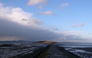
. It is 1/3 mi long and covers 7.7 hectares (19 acre), and is currently part of the Dalmeny
Dalmeny House
Dalmeny House is a Gothic revival mansion located in an estate close to Dalmeny on the Firth of Forth, to the north-west of Edinburgh, Scotland. It was designed by William Wilkins, and completed in 1817.Dalmeny House is the home of the Earl and Countess of Rosebery. The house was the first in...
Estate.
Strictly speaking it is not a true island at all, but a tidal island
Tidal island
A tidal island is a piece of land that is connected to the mainland by a natural or man-made causeway that is exposed at low tide and submerged at high tide. Because of the mystique surrounding tidal islands many of them have been sites of religious worship, such as Mont Saint Michel with its...
being connected to the mainland at low tide. There is a paved path, exposed at low tide, which allows easy access. This path runs at the foot of a row of concrete pylons on one side of the causeway which were constructed as a submarine defence boom and are one of the most striking sights in the area. At high tide the island is cut off from the mainland, with the path several feet below sea level. It lies about a mile from the shore, and visitors should take care to leave sufficient time to walk back to the mainland. The speed with which the water rises can catch people unawares, leaving them stranded. The island forms part of the estuary
Estuary
An estuary is a partly enclosed coastal body of water with one or more rivers or streams flowing into it, and with a free connection to the open sea....
of the River Almond
River Almond, Lothian
The River Almond is a river in east-central Scotland. It is 28 miles long, rising in North Lanarkshire near Shotts and runs through West Lothian, draining into the Firth of Forth at Cramond near Edinburgh....
whose mouth is near the landward end of the crossing. It is a popular recreation area.
History
Cist
A cist from ) is a small stone-built coffin-like box or ossuary used to hold the bodies of the dead. Examples can be found across Europe and in the Middle East....
was found.
As nearby Cramond was a Roman outpost
Cramond Roman Fort
Cramond Roman Fort is a Roman-Era archaeological site at Cramond, Edinburgh, Scotland. In the Ravenna Cosmography this settlement is called "Caromago". The fort was established around 140 AD and occupied until around 170, with a further period of occupation from around 208 to 211...
, it is likely that it may have been used by them. The Roman presence in Scotland was not particularly strong, but Cramond is one of the most archaeologically rich sites, along with Trimontium near Melrose
Melrose, Scotland
Melrose is a small town and civil parish in the Scottish Borders, historically in Roxburghshire. It is in the Eildon committee area.-Etymology:...
.
Throughout most of its history, Cramond Island was used for farming, especially sheep-farming, and perhaps served as a fishing outpost as well. The island was once famous for its oyster
Oyster
The word oyster is used as a common name for a number of distinct groups of bivalve molluscs which live in marine or brackish habitats. The valves are highly calcified....
beds, but these were destroyed due to overfishing. In the north west corner of the island there are remains of a jetty
Jetty
A jetty is any of a variety of structures used in river, dock, and maritime works that are generally carried out in pairs from river banks, or in continuation of river channels at their outlets into deep water; or out into docks, and outside their entrances; or for forming basins along the...
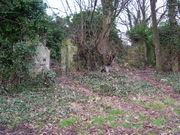
built with local stone which could be medieval in origin, while towards the centre of the island, half-hidden by a small wood there is the ruin of a stone-built farmstead. It appears on an Ordnance Survey
Ordnance Survey
Ordnance Survey , an executive agency and non-ministerial government department of the Government of the United Kingdom, is the national mapping agency for Great Britain, producing maps of Great Britain , and one of the world's largest producers of maps.The name reflects its creation together with...
map of 1853, but may be considerably older. It was occupied until the 1930s and sheep were still kept on the island as late as the 1960s.
World War II

Searchlight
A searchlight is an apparatus that combines a bright light source with some form of curved reflector or other optics to project a powerful beam of light of approximately parallel rays in a particular direction, usually constructed so that it can be swiveled about.-Military use:The Royal Navy used...
. More buildings are in the north east corner of the island, which include a variety of stores, shelters and gun emplacements, as well as two engine rooms that once contained all the equipment necessary to supply power to the military installations on the island.
Further along the northern coast, low concrete stumps protrude from the undergrowth, all that remain of the barracks
Barracks
Barracks are specialised buildings for permanent military accommodation; the word may apply to separate housing blocks or to complete complexes. Their main object is to separate soldiers from the civilian population and reinforce discipline, training and esprit de corps. They were sometimes called...
that housed the garrison
Garrison
Garrison is the collective term for a body of troops stationed in a particular location, originally to guard it, but now often simply using it as a home base....
on the island.
On the western side is small brick building of unknown purpose. Nearby, perched precariously on the rocky shore is the ruin of a small square building which was used as an ammunition
Ammunition
Ammunition is a generic term derived from the French language la munition which embraced all material used for war , but which in time came to refer specifically to gunpowder and artillery. The collective term for all types of ammunition is munitions...
store during the war, though its stone construction suggests it is much older than either World War, possibly contemporary with the farmstead in the middle of the island.