

List of outlying islands of Scotland
Encyclopedia
Hebrides
The Hebrides comprise a widespread and diverse archipelago off the west coast of Scotland. There are two main groups: the Inner and Outer Hebrides. These islands have a long history of occupation dating back to the Mesolithic and the culture of the residents has been affected by the successive...
, the Northern Isles
Northern Isles
The Northern Isles is a chain of islands off the north coast of mainland Scotland. The climate is cool and temperate and much influenced by the surrounding seas. There are two main island groups: Shetland and Orkney...
or the Islands of the Forth
Islands of the Forth
The Islands of the Forth are a minor island group to the east of Scotland. The open waters of the Firth of Forth lie between Fife and the Lothians and contain most of the islands. The majority lie east of city of Edinburgh although two are to the west and two more lie in the estuary of the River...
and Clyde
Islands of the Clyde
The Islands of the Firth of Clyde are the fifth largest of the major Scottish island groups after the Inner and Outer Hebrides, Orkney and Shetland. They are situated in the Firth of Clyde between Ayrshire and Argyll. There are about forty islands and skerries, of which only six are inhabited and...
estuaries. None of these islands are currently inhabited and few of them ever were, although Hirta
Hirta
Hirta is the largest island in the St Kilda archipelago, on the western edge of Scotland. The name "Hiort" and "Hirta" have also been applied to the entire archipelago.-Geography:...
was occupied from the Neolithic
Neolithic
The Neolithic Age, Era, or Period, or New Stone Age, was a period in the development of human technology, beginning about 9500 BC in some parts of the Middle East, and later in other parts of the world. It is traditionally considered as the last part of the Stone Age...
age until 1930 and Stroma
Stroma, Scotland
Stroma is an island off the northern coast of the Scottish mainland. It is the more southerly of the two islands in the Pentland Firth between the Orkney Islands and Caithness. It is administratively part of Caithness , while its neighbour Swona, to the north, is part of the Orkney Islands...
was permanently occupied until the 1970s and thereafter by lighthouse keepers and their families until 1996. Several other outlying islands have lighthouses, none of which are still manned.
In this list, an island is defined as "land that is surrounded by seawater on a daily basis, but not necessarily at all stages of the tide, excluding human devices such as bridges and causeways". A complication relating to membership of this list is that there are various descriptions of the scope of The Hebrides, the large group of islands that lie off Scotland's west coast. The Collins Encyclopedia of Scotland describes the Inner Hebrides
Inner Hebrides
The Inner Hebrides is an archipelago off the west coast of Scotland, to the south east of the Outer Hebrides. Together these two island chains form the Hebrides, which enjoy a mild oceanic climate. There are 36 inhabited islands and a further 43 uninhabited Inner Hebrides with an area greater than...
as lying "east of The Minch
The Minch
The Minch , also called The North Minch, is a strait in north-west Scotland, separating the north-west Highlands, and the northern Inner Hebrides, from Lewis and Harris in the Outer Hebrides...
", which would include any and all offshore islands. There are various islands that lie in the sea loch
Loch
Loch is the Irish and Scottish Gaelic word for a lake or a sea inlet. It has been anglicised as lough, although this is pronounced the same way as loch. Some lochs could also be called a firth, fjord, estuary, strait or bay...
s such as Eilean Bàn and Eilean Donan
Eilean Donan
Eilean Donan is a small island in Loch Duich in the western Highlands of Scotland. It is connected to the mainland by a footbridge and lies about half a mile from the village of Dornie. Eilean Donan is named after Donnán of Eigg, a Celtic saint martyred in 617...
that might not ordinarily be described as "Hebridean" but no formal definitions exist and for simplicity they are included in the List of Inner Hebrides rather than here.Encyclopædia Britannica (1978) says: Hebrides – group of islands of the west coast of Scotland extending in an arc between 55.35 and 58.30 N and 5.26 and 8.40 W." This includes Gigha
Gigha
The Isle of Gigha is a small island off the west coast of Kintyre in Scotland. The island forms part of Argyll and Bute and has a population of about 150 people, many of whom speak Scottish Gaelic. The climate is mild with higher than average sunshine hours and the soils are fertile.Gigha has a...
, St Kilda and everything up to Cape Wrath
Cape Wrath
Cape Wrath is a cape in Sutherland, Highland, in northern Scotland. It is the most northwesterly point on the island of Great Britain. The land between the Kyle of Durness and the lighthouse that is situated right at the tip, is known as the Parph, two hundred and seven square kilometers of...
– although not North Rona.
Main islands


St Kilda, Scotland
St Kilda is an isolated archipelago west-northwest of North Uist in the North Atlantic Ocean. It contains the westernmost islands of the Outer Hebrides of Scotland. The largest island is Hirta, whose sea cliffs are the highest in the United Kingdom and three other islands , were also used for...
archipelago which lies 64 kilometres (39.8 mi) west-northwest of North Uist and is now a World Heritage Site
World Heritage Site
A UNESCO World Heritage Site is a place that is listed by the UNESCO as of special cultural or physical significance...
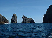
. It is one of the few to hold joint status for its natural and cultural qualities. At 196 metres (643 ft) Stac an Armin
Stac an Armin
Stac an Armin , based on the proper Scottish Gaelic spelling , is a sea stack in the St Kilda archipelago. It is 196 metres tall, qualifying it as a Marilyn...
is the highest sea stack in the British Isles and in July 1840, the last Great Auk
Great Auk
The Great Auk, Pinguinus impennis, formerly of the genus Alca, was a large, flightless alcid that became extinct in the mid-19th century. It was the only modern species in the genus Pinguinus, a group of birds that formerly included one other species of flightless giant auk from the Atlantic Ocean...
seen in the British Isles was captured there.
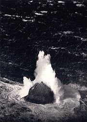
East of St Kilda are the Flannan Isles
Flannan Isles
Designed by David Alan Stevenson, the tower was constructed for the Northern Lighthouse Board between 1895 and 1899 and is located near the highest point on Eilean Mòr. Construction was undertaken by George Lawson of Rutherglen at a cost of £6,914 inclusive of the building of the landing places,...
, the location of an enduring mystery which occurred in December 1900, when all three lighthouse keepers vanished without trace. Further north and east are the two outliers of Sula Sgeir
Sula Sgeir
Sula Sgeir is a small, uninhabited Scottish island in the North Atlantic, west of North Rona...
and North Rona
North Rona
Rona is a remote Scottish island in the North Atlantic. Rona is often referred to as North Rona in order to distinguish it from South Rona . It has an area of and a maximum height of...
, which have strong cultural links to the Outer Hebrides
Outer Hebrides
The Outer Hebrides also known as the Western Isles and the Long Island, is an island chain off the west coast of Scotland. The islands are geographically contiguous with Comhairle nan Eilean Siar, one of the 32 unitary council areas of Scotland...
. North Rona is 71 kilometres (44.1 mi) north north east of Butt of Lewis
Butt of Lewis
The Butt of Lewis is the most northerly point of the Isle of Lewis in the Outer Hebrides. The headland, which lies in the North Atlantic, is frequently battered by heavy swells and storms.-Lighthouse:...
and 18 kilometres (11.2 mi) east of Sula Sgeir. It is the remotest island in the British Isles
British Isles
The British Isles are a group of islands off the northwest coast of continental Europe that include the islands of Great Britain and Ireland and over six thousand smaller isles. There are two sovereign states located on the islands: the United Kingdom of Great Britain and Northern Ireland and...
to have ever been inhabited on a long-term basis. It is also closer than any other part of Scotland to the Faroe Islands
Faroe Islands
The Faroe Islands are an island group situated between the Norwegian Sea and the North Atlantic Ocean, approximately halfway between Scotland and Iceland. The Faroe Islands are a self-governing territory within the Kingdom of Denmark, along with Denmark proper and Greenland...
. Sule Skerry
Sule Skerry
Sule Skerry is a remote skerry in the North Atlantic off the north coast of Scotland.-Geography:Sule Skerry lies 60 kilometres west of the Orkney Mainland at . Sule Skerry's sole neighbour, Sule Stack, lies 10km to the southwest. The remote islands of Rona and Sula Sgeir lie approximately 80km...
and Sule Stack
Sule Stack
Sule Stack or Stack Skerry is an extremely remote island or stack in the North Atlantic off the north coast of Scotland. It is formed of Lewisian gneiss.Sule Stack lies 66 kilometres west of the Orkney mainland at...
lie further east and are administratively part of Orkney.
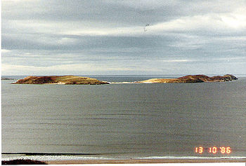
The islands of the north coast are remote from the main centres of population, although for the most part lie close to the shores of the mainland. There is a small group of larger islands near Tongue Bay but the largest on this coast is Stroma in the Pentland Firth
Pentland Firth
The Pentland Firth , which is actually more of a strait than a firth, separates the Orkney Islands from Caithness in the north of Scotland.-Etymology:...
, which lies between Caithness
Caithness
Caithness is a registration county, lieutenancy area and historic local government area of Scotland. The name was used also for the earldom of Caithness and the Caithness constituency of the Parliament of the United Kingdom . Boundaries are not identical in all contexts, but the Caithness area is...
and Orkney. Innis Mhòr
Innis Mhòr
Innis Mhòr is a tidal island in the Dornoch Firth of Easter Ross off the east coast of Scotland. It is about in extent and is largely, if not exclusively made up of moving sand dunes. No point on the island is greater than above sea level. It has almost certainly never been permanently inhabited...
in the Dornoch Firth
Dornoch Firth
The Dornoch Firth is a firth on the east coast of Highland, in northern Scotland. It forms part of the boundary between Ross and Cromarty, to the south, and Sutherland, to the north....
is the largest of a handful of small islets off the coast of Easter Ross
Easter Ross
Easter Ross is a loosely defined area in the east of Ross, Highland, Scotland.The name is used in the constituency name Caithness, Sutherland and Easter Ross, which is the name of both a British House of Commons constituency and a Scottish Parliament constituency...
. Further south are Inchcape
Inchcape
Inchcape or the Bell Rock is a notorious reef off the east coast of Angus, Scotland, near Dundee and Fife . Bell Rock Lighthouse, an automatic lighthouse, occupies the reef...
off the coast of Angus
Angus
Angus is one of the 32 local government council areas of Scotland, a registration county and a lieutenancy area. The council area borders Aberdeenshire, Perth and Kinross and Dundee City...
, and Mugdrum, the only substantial island in the Firth of Tay
Firth of Tay
The Firth of Tay is a firth in Scotland between the council areas of Fife, Perth and Kinross, the City of Dundee and Angus, into which Scotland's largest river in terms of flow, the River Tay, empties....
. There is a cluster of islands in the Solway Firth
Solway Firth
The Solway Firth is a firth that forms part of the border between England and Scotland, between Cumbria and Dumfries and Galloway. It stretches from St Bees Head, just south of Whitehaven in Cumbria, to the Mull of Galloway, on the western end of Dumfries and Galloway. The Isle of Man is also very...
that marks the south western border of Scotland, including the Islands of Fleet, in Wigtown Bay
Wigtown
Wigtown is a town and former royal burgh in the Machars of Galloway in the south west of Scotland. It lies south of Newton Stewart and east of Stranraer. It has a population of about 1,000...
.
Most of the smaller islets that surround those in the main list are obscure and none have ever been permanently inhabited in modern times. Nonetheless, some have a degree of historical significance. Castle Mestag off Stroma is the ruins of a once fortified stack accessible only via a drawbridge. Some islets are identified as "storm washed" meaning that, although a proportion of their bulk remains above mean sea level
Sea level
Mean sea level is a measure of the average height of the ocean's surface ; used as a standard in reckoning land elevation...
, large waves wash over the top of them during storms, rendering them uninhabitable.
Finally, there is lonely Rockall
Rockall
Rockall is an extremely small, uninhabited, remote rocky islet in the North Atlantic Ocean. It gives its name to one of the sea areas named in the shipping forecast provided by the British Meteorological Office....
, which is 367 kilometres (228 mi) to the west of North Uist
North Uist
North Uist is an island and community in the Outer Hebrides of Scotland.-Geography:North Uist is the tenth largest Scottish island and the thirteenth largest island surrounding Great Britain. It has an area of , slightly smaller than South Uist. North Uist is connected by causeways to Benbecula...
. It is a small rocky islet in the North Atlantic which could be, in James Fisher
James Fisher
James Maxwell McConnell Fisher was a British author, editor, broadcaster, naturalist and ornithologist...
's words, "the most isolated small rock in the oceans of the world" and which was declared part of Scotland by the Island of Rockall Act 1972
Island of Rockall Act 1972
The Island of Rockall Act 1972 is a British Act of Parliament formally incorporating the island Rockall into the United Kingdom to protect it from Irish and Icelandic claims...
. However, the legality of the claim is disputed by the Republic of Ireland, Denmark and Iceland and it is probably unenforceable in international law.
| Island | Group | Area (ha Hectare The hectare is a metric unit of area defined as 10,000 square metres , and primarily used in the measurement of land. In 1795, when the metric system was introduced, the are was defined as being 100 square metres and the hectare was thus 100 ares or 1/100 km2... ) |
Height (m) | Light | Last inhabited | Surrounding islets |
|---|---|---|---|---|---|---|
| Ardwall Isle | Islands of Fleet Islands of Fleet The Islands of Fleet are a group of small islands in Galloway, Scotland. They are in Fleet Bay, which is part of Wigtown Bay, which is in turn part of the Solway Firth in the Irish Sea... |
22 | 34 | No | Old Man of Fleet | |
| Barlocco Isle | Islands of Fleet Islands of Fleet The Islands of Fleet are a group of small islands in Galloway, Scotland. They are in Fleet Bay, which is part of Wigtown Bay, which is in turn part of the Solway Firth in the Irish Sea... |
10 | 10 | No | The Three Brethren | |
| Big Scare | Solway Firth Solway Firth The Solway Firth is a firth that forms part of the border between England and Scotland, between Cumbria and Dumfries and Galloway. It stretches from St Bees Head, just south of Whitehaven in Cumbria, to the Mull of Galloway, on the western end of Dumfries and Galloway. The Isle of Man is also very... |
<1 | 21 | No | Little Scares (3) | |
| Boreray Boreray, St Kilda Boreray is an uninhabited island in the St Kilda archipelago in the North Atlantic.-Geography:Boreray lies about 66 km west-north-west of North Uist. It covers about , and reaches a height of at Mullach an Eilein.... |
St Kilda St Kilda, Scotland St Kilda is an isolated archipelago west-northwest of North Uist in the North Atlantic Ocean. It contains the westernmost islands of the Outer Hebrides of Scotland. The largest island is Hirta, whose sea cliffs are the highest in the United Kingdom and three other islands , were also used for... |
77 | 384 | No | An t-Sail, Sgarbhstac | |
| Bròna Cleit | Flannan Isles Flannan Isles Designed by David Alan Stevenson, the tower was constructed for the Northern Lighthouse Board between 1895 and 1899 and is located near the highest point on Eilean Mòr. Construction was undertaken by George Lawson of Rutherglen at a cost of £6,914 inclusive of the building of the landing places,... |
1 | 20c. 20 | No | ||
| Dùn Dùn, St Kilda Dùn is an island in the St Kilda archipelago. It is nearly a mile long. Its name simply means "fort" in Scottish Gaelic , but the fort itself has been lost - old maps show it on Gob an Dùin , which is at the seaward end.Almost joined to Hirta at Ruiaval, the two islands are separated by Caolas an... |
St Kilda St Kilda, Scotland St Kilda is an isolated archipelago west-northwest of North Uist in the North Atlantic Ocean. It contains the westernmost islands of the Outer Hebrides of Scotland. The largest island is Hirta, whose sea cliffs are the highest in the United Kingdom and three other islands , were also used for... |
32 | 178 | No | Hamalan, Giasgeir, Sgeir Cul an Rubha, Sgeir Mhòr | |
| Eilean a' Ghobha | Flannan Isles Flannan Isles Designed by David Alan Stevenson, the tower was constructed for the Northern Lighthouse Board between 1895 and 1899 and is located near the highest point on Eilean Mòr. Construction was undertaken by George Lawson of Rutherglen at a cost of £6,914 inclusive of the building of the landing places,... |
8 | 57 | No | ||
| Eilean Choraidh Eilean Choraidh Eilean Choraidh, also known as Horse Island is an island in Loch Eriboll in Sutherland on the north coast of Scotland. It is about in extent and the highest point is above sea level.... |
Loch Eriboll Loch Eriboll Loch Eriboll is a long sea loch on the north coast of Scotland, which has been used for centuries as a deep water anchorage as it is safe from the often stormy seas of Cape Wrath and the Pentland Firth... |
20 | 26 | No | A' chlèit | |
| Eilean Hoan Eilean Hoan Eilean Hoan is an island in Loch Eriboll in Sutherland on the north coast of Scotland. It is about in extent and the highest point is above sea level. Its name is of Gaelic and Old Norse derivation and means "haven island".... |
Loch Eriboll Loch Eriboll Loch Eriboll is a long sea loch on the north coast of Scotland, which has been used for centuries as a deep water anchorage as it is safe from the often stormy seas of Cape Wrath and the Pentland Firth... |
22 | 25 | No | A' Ghoil-sgeir, An Cruachan, An Dubh-sgeir, Eilean Clùimhrig, Pocan Smoo | |
| Eilean Mòr | Flannan Isles Flannan Isles Designed by David Alan Stevenson, the tower was constructed for the Northern Lighthouse Board between 1895 and 1899 and is located near the highest point on Eilean Mòr. Construction was undertaken by George Lawson of Rutherglen at a cost of £6,914 inclusive of the building of the landing places,... |
88 | Yes | Deirc na Sgeir, Làmh à Sgeir Beag, Làmh an Sgeir Mòire | ||
| Eilean nan Ròn Eilean nan Ròn Eilean nan Ròn is an island near Skerray, in the north of Sutherland, Scotland. 350 seal pups are born here annually.-History:Eilean nan Ròn was populated for many years, with seventy three people living there in 1881 and 30 in 1931. It has been uninhabited since 1938... |
Tongue Bay Tongue, Highland Tongue is a coastal village in northwest Highland, Scotland, in the western part of the former county of Sutherland. It lies on the east shore above the base of the Kyle of Tongue and north of the mountains Ben Hope and Ben Loyal... |
138 | 76 | No | An Innis, Eilean Iosal, Meall Thailm | |
| Eilean Taighe | Flannan Isles Flannan Isles Designed by David Alan Stevenson, the tower was constructed for the Northern Lighthouse Board between 1895 and 1899 and is located near the highest point on Eilean Mòr. Construction was undertaken by George Lawson of Rutherglen at a cost of £6,914 inclusive of the building of the landing places,... |
11 | 59 | No | Gealtaire Beag, Gealtaire Mòr, Hamasgeir | |
| Hestan Island Hestan Island Hestan Island is a small coastal island in the Solway Firth, southwest Scotland.Hestan Island lies at the mouth of Auchencairn Bay in the region of Dumfries and Galloway in the former county of Kirkcudbrightshire... |
Solway Firth Solway Firth The Solway Firth is a firth that forms part of the border between England and Scotland, between Cumbria and Dumfries and Galloway. It stretches from St Bees Head, just south of Whitehaven in Cumbria, to the Mull of Galloway, on the western end of Dumfries and Galloway. The Isle of Man is also very... |
11c.11 | 54 | Yes | ||
| Hirta Hirta Hirta is the largest island in the St Kilda archipelago, on the western edge of Scotland. The name "Hiort" and "Hirta" have also been applied to the entire archipelago.-Geography:... |
St Kilda St Kilda, Scotland St Kilda is an isolated archipelago west-northwest of North Uist in the North Atlantic Ocean. It contains the westernmost islands of the Outer Hebrides of Scotland. The largest island is Hirta, whose sea cliffs are the highest in the United Kingdom and three other islands , were also used for... |
670 | 430 | No | An Torc, Bradastac, Mina Stac, Sgeir Domhnuill, Sgeir Mhòr, Sgeir nan Sgarbh | |
| Inchcape Inchcape Inchcape or the Bell Rock is a notorious reef off the east coast of Angus, Scotland, near Dundee and Fife . Bell Rock Lighthouse, an automatic lighthouse, occupies the reef... |
Angus Angus Angus is one of the 32 local government council areas of Scotland, a registration county and a lieutenancy area. The council area borders Aberdeenshire, Perth and Kinross and Dundee City... coast |
0 | Yes | |||
| Innis Mhòr Innis Mhòr Innis Mhòr is a tidal island in the Dornoch Firth of Easter Ross off the east coast of Scotland. It is about in extent and is largely, if not exclusively made up of moving sand dunes. No point on the island is greater than above sea level. It has almost certainly never been permanently inhabited... |
Easter Ross Easter Ross Easter Ross is a loosely defined area in the east of Ross, Highland, Scotland.The name is used in the constituency name Caithness, Sutherland and Easter Ross, which is the name of both a British House of Commons constituency and a Scottish Parliament constituency... |
26 | <5 | No | ||
| Little Ross Little Ross Little Ross is a small island with a lighthouse in Dumfries and Galloway, Scotland. It is next to Meikle Ross on the mainland, which is a headland, and there are two small rocks off it, Sugarloaf and Fox Craig.-Lighthouse:... |
Solway Firth Solway Firth The Solway Firth is a firth that forms part of the border between England and Scotland, between Cumbria and Dumfries and Galloway. It stretches from St Bees Head, just south of Whitehaven in Cumbria, to the Mull of Galloway, on the western end of Dumfries and Galloway. The Isle of Man is also very... |
7 | 35 | Yes | Sugarloaf | |
| Mugdrum | Firth of Tay Firth of Tay The Firth of Tay is a firth in Scotland between the council areas of Fife, Perth and Kinross, the City of Dundee and Angus, into which Scotland's largest river in terms of flow, the River Tay, empties.... |
32 | 4 | No | ||
| Murray's Isles | Islands of Fleet Islands of Fleet The Islands of Fleet are a group of small islands in Galloway, Scotland. They are in Fleet Bay, which is part of Wigtown Bay, which is in turn part of the Solway Firth in the Irish Sea... |
1 | 5c.5 | No | Horse Mark | |
| Neave Island Neave Island Neave Island is an island on the north coast of the Scottish mainland.Neave Island is a small rugged island to the east of Eilean nan Ròn in Sutherland, separated from the mainland by a narrow channel, Caol Beag.. It lies between Bettyhill and Tongue and has a sandy beach at the eastern end There... |
Tongue Bay | 23 | 70 | No | Stac an Fhamhair | |
| North Rona North Rona Rona is a remote Scottish island in the North Atlantic. Rona is often referred to as North Rona in order to distinguish it from South Rona . It has an area of and a maximum height of... |
North west | 109 | 108 | No | Gealldraig Mhòr, Lòba Sgeir | |
| Rabbit Islands Rabbit Islands, Scotland The Rabbit Islands are a group of three uninhabited small islands off the north coast of Sutherland, Scotland in Tongue Bay. In Scottish Gaelic, and occasionally in English, they are known as Eileanan nan Gall, which is sometimes anglicised as "Eilean-na-Gaeil" or "Eilean nan Gaill".-Geography... |
Tongue Bay | 32 | 45 | No | Dubh Sgeir-Mhòr, Eilean á Chaoil, Eilean Creagach, Sgeir an Òir, Talmine Island | |
| Roaireim | Flannan Isles Flannan Isles Designed by David Alan Stevenson, the tower was constructed for the Northern Lighthouse Board between 1895 and 1899 and is located near the highest point on Eilean Mòr. Construction was undertaken by George Lawson of Rutherglen at a cost of £6,914 inclusive of the building of the landing places,... |
5 | 52 | No | ||
| Rockall Rockall Rockall is an extremely small, uninhabited, remote rocky islet in the North Atlantic Ocean. It gives its name to one of the sea areas named in the shipping forecast provided by the British Meteorological Office.... |
North Atlantic | No | Hasselwood Rock Hasselwood Rock Hasselwood Rock is a skerry adjacent to Rockall in the northern part of Atlantic Ocean.- Position and characteristics :Its upper part is the destroyed cone of an extinct volcano, situated 200 meters north of the larger outcrop of Rockall.... , Helen's Reef Helen's Reef Helen's Reef is a series of skerries in the North Atlantic, 2km to the North-East of the larger Islet of Rockall and outcrop of Hasselwood Rock.... |
|||
| Rough Island Rough Island, Scotland Rough Island is a tidal island in Rough Firth off the Solway Firth, Scotland. It is 24 m at its highest point.Since 1937 it has been in the ownership of the National Trust for Scotland... |
Solway Firth Solway Firth The Solway Firth is a firth that forms part of the border between England and Scotland, between Cumbria and Dumfries and Galloway. It stretches from St Bees Head, just south of Whitehaven in Cumbria, to the Mull of Galloway, on the western end of Dumfries and Galloway. The Isle of Man is also very... |
8 | No | Craig Roan, Spring Stones | ||
| Sgeir Toman | Flannan Isles Flannan Isles Designed by David Alan Stevenson, the tower was constructed for the Northern Lighthouse Board between 1895 and 1899 and is located near the highest point on Eilean Mòr. Construction was undertaken by George Lawson of Rutherglen at a cost of £6,914 inclusive of the building of the landing places,... |
4 | 43 | No | Sgeir Righinn | |
| Soay Soay, St Kilda Soay is an uninhabited islet in the St Kilda archipelago, Scotland. The island is part of the St Kilda World Heritage Site and home to a primitive breed of sheep... |
St Kilda St Kilda, Scotland St Kilda is an isolated archipelago west-northwest of North Uist in the North Atlantic Ocean. It contains the westernmost islands of the Outer Hebrides of Scotland. The largest island is Hirta, whose sea cliffs are the highest in the United Kingdom and three other islands , were also used for... |
99 | 378 | No | Am Plastair, Sgeir Mac Righ Lochlainn, Stac Biorach Stac Biorach Stac Biorach is a sea stack, 73 metres tall, situated between Hirta and Soay in the St Kilda archipelago of Scotland... , Stac Dona, Stac Soay. |
|
| Soraigh | Flannan Isles Flannan Isles Designed by David Alan Stevenson, the tower was constructed for the Northern Lighthouse Board between 1895 and 1899 and is located near the highest point on Eilean Mòr. Construction was undertaken by George Lawson of Rutherglen at a cost of £6,914 inclusive of the building of the landing places,... |
6 | 41 | No | ||
| Stac an Armin Stac an Armin Stac an Armin , based on the proper Scottish Gaelic spelling , is a sea stack in the St Kilda archipelago. It is 196 metres tall, qualifying it as a Marilyn... |
St Kilda St Kilda, Scotland St Kilda is an isolated archipelago west-northwest of North Uist in the North Atlantic Ocean. It contains the westernmost islands of the Outer Hebrides of Scotland. The largest island is Hirta, whose sea cliffs are the highest in the United Kingdom and three other islands , were also used for... |
9 | 196 | No | ||
| Stac Lee Stac Lee Stac Lee is a sea stack in the St Kilda group, Scotland. An island Marilyn, it is home to part of the world's largest colony of Northern Gannet.-Geography and geology:Martin Martin called the island "Stac-Ly"; other sources call it "Stac Lii."... |
St Kilda St Kilda, Scotland St Kilda is an isolated archipelago west-northwest of North Uist in the North Atlantic Ocean. It contains the westernmost islands of the Outer Hebrides of Scotland. The largest island is Hirta, whose sea cliffs are the highest in the United Kingdom and three other islands , were also used for... |
1 | 172 | No | ||
| Stac Levenish Stac Levenish Stac Levenish or Stac Leibhinis is a sea stack in the St Kilda archipelago in Scotland. Lying 2½ km off Village Bay on Hirta, it is part of the rim of an extinct volcano that includes Dùn, Ruaival and Mullach Sgar.The stack is high... |
St Kilda St Kilda, Scotland St Kilda is an isolated archipelago west-northwest of North Uist in the North Atlantic Ocean. It contains the westernmost islands of the Outer Hebrides of Scotland. The largest island is Hirta, whose sea cliffs are the highest in the United Kingdom and three other islands , were also used for... |
<1 | 62 | No | Na Bodhan | |
| Stroma Stroma, Scotland Stroma is an island off the northern coast of the Scottish mainland. It is the more southerly of the two islands in the Pentland Firth between the Orkney Islands and Caithness. It is administratively part of Caithness , while its neighbour Swona, to the north, is part of the Orkney Islands... |
Caithness Caithness Caithness is a registration county, lieutenancy area and historic local government area of Scotland. The name was used also for the earldom of Caithness and the Caithness constituency of the Parliament of the United Kingdom . Boundaries are not identical in all contexts, but the Caithness area is... |
375 | 53 | Yes | Castle Mestag | |
| Sula Sgeir Sula Sgeir Sula Sgeir is a small, uninhabited Scottish island in the North Atlantic, west of North Rona... |
North west | 15 | 70 | Yes | Bogha Córr, Grallsgeir | |
| Sule Skerry Sule Skerry Sule Skerry is a remote skerry in the North Atlantic off the north coast of Scotland.-Geography:Sule Skerry lies 60 kilometres west of the Orkney Mainland at . Sule Skerry's sole neighbour, Sule Stack, lies 10km to the southwest. The remote islands of Rona and Sula Sgeir lie approximately 80km... |
Orkney | 16 | 12 | Yes | ||
| Sule Stack Sule Stack Sule Stack or Stack Skerry is an extremely remote island or stack in the North Atlantic off the north coast of Scotland. It is formed of Lewisian gneiss.Sule Stack lies 66 kilometres west of the Orkney mainland at... |
Orkney | 36 | No | |||
Smaller islets off the mainland
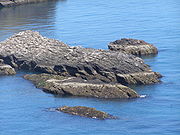
Skerry
A skerry is a small rocky island, usually defined to be too small for habitation. It may simply be a rocky reef. A skerry can also be called a low sea stack....
that are only exposed at lower stages of the tide in the seas surrounding the mainland of Scotland. Craiglethy is part of the Fowlsheugh
Fowlsheugh
Fowlsheugh is a coastal nature reserve in Kincardineshire, northeast Scotland, known for its seventy metre high cliff formations and habitat supporting prolific seabird nesting colonies. Designated as a Site of Special Scientific Interest by Scottish Natural Heritage, the property is owned by the...
nature reserve
Nature reserve
A nature reserve is a protected area of importance for wildlife, flora, fauna or features of geological or other special interest, which is reserved and managed for conservation and to provide special opportunities for study or research...
. The Three Kings, off the coast of Easter Ross near Balintore
Balintore
Balintore is a village near Tain in Easter Ross, Scotland.It is one of three villages on this northern stretch of the Moray Firth coastline - Hilton, Balintore, and Shandwick are known collectively as the Seaboard Villages. Local employment has long been based on fishing, but this is now only a...
, is also known as Creag Harail or Harold's Rock and called The King's Sons in the New Statistical Account of Scotland
Statistical Accounts of Scotland
The Statistical Accounts of Scotland are three series of documentary publications covering life in Scotland in the 18th, 19th and 20th centuries....
. According to legend, three sons of a Danish prince, sailing to avenge their sister's wrongs, were wrecked here and gave these rocks their collective name. Their graves were marked by the sculptured stones of Nigg
Nigg, Highland
Nigg is a village and parish on the north east shore of Nigg Bay in north east Ross-shire and is in the Scottish council area of Highland...
, Shandwick and Hilton of Cadboll
Hilton of Cadboll
Hilton of Cadboll, or simply Hilton, is a village about southeast of Tain in Easter Ross, is in the Scottish council area of Highland It is famous for the Hilton of Cadboll Stone....
. Another story has their burial at Nigg Rocks below the North Sutor.
- Solway Firth: InchSt Mary's Isle PriorySt Mary's Isle Priory was a monastic house of Augustinian canons located on the Isle of Trail or St Mary's Isle in Galloway. It is alleged to have originated in an endowment of the island by King Fergus of Galloway in favour of Holyrood Abbey...
- North coast (from west to east): Stac an Dunain, Duslic, Stack Clò Kearvaig, An Garbh-eilean, Na Glas Leacan, Eilean Dubh, Clach Bheag na Faraid, Clach Mhòr na Faraid, Àigeach, Eilean Polsain, Boursa Island, Glas-eilean Mòr, Garbh-eilean, Wester Clett, Middle Clett, Easter Clett, Little Clett, ClettClettClett is a small uninhabited Scottish islet near the north coast of Caithness, just to the west Holborn Head north of Scrabster....
. - East coast:
- North Moray FirthMoray FirthThe Moray Firth is a roughly triangular inlet of the North Sea, north and east of Inverness, which is in the Highland council area of north of Scotland...
(from north to south): The Knee, Stacks of Duncansby, Stack o' Brough, South Stack, The Stacks, Eilean na h-Aibhne, Three Kings. - South Moray Firth (from west to east): Covesea SkerriesCovesea Skerries LighthouseCovesea Skerries Lighthouse, belonging to the Northern Lighthouse Board , is built on top of a small headland on the south coast of the Moray Firth at Covesea, near Lossiemouth, Moray, Scotland.-History:...
, Halliman Skerries, Boar's Head Rock, West Muck, East Muck, Craigenroan, Bow Fiddle Rock, Collie Rocks, Craigandargity. - Kinnaird Head to the Bullers of BuchanBullers of BuchanThe name Bullers of Buchan refers both to a collapsed sea cave and to the adjacent village, situated about south of Peterhead in Buchan, Aberdeenshire, Scotland.- Cave :...
: The Ron, The Skerry, Miekle Mackie, Miekle Donnon, Little Donnon, Craig Snow, Meikle Dumeath, Little Dumeath. - Bullers of Buchan to Girdle Ness: Dunbuy, The Donnons, Skellyis of Harrol.
- Girdle Ness to Buddon Ness: CraiglethyCraiglethyCraiglethy is a small island/skerry off Fowlsheugh on the east coast of Aberdeenshire, Scotland in the North Sea. As it is part of Fowlsheugh, it is an SSSI, with many seabirds and seals living on it...
, CraigmaroinnCraigmaroinnCraigmaroinn is a skerry in the North Sea near the Aberdeenshire coastline in Scotland. Craigmaroinn is situated midway between the coastal villages of Portlethen Village and Downies...
, May CraigMay Craig (island)May Craig is a rocky island situated along the North Sea coast of Aberdeenshire, Scotland. May Craig lies about one half mile south of Newtonhill and a mile northeast of the village of Muchalls...
.
- North Moray Firth
Other than Mugdrum in the Firth of Tay and the Islands of the Forth
Islands of the Forth
The Islands of the Forth are a minor island group to the east of Scotland. The open waters of the Firth of Forth lie between Fife and the Lothians and contain most of the islands. The majority lie east of city of Edinburgh although two are to the west and two more lie in the estuary of the River...
there are no genuine islands on the east coast of Scotland south of Buddon Ness.