

Tidal island
Encyclopedia
A tidal island is a piece of land that is connected to the mainland by a natural or man-made causeway
Causeway
In modern usage, a causeway is a road or railway elevated, usually across a broad body of water or wetland.- Etymology :When first used, the word appeared in a form such as “causey way” making clear its derivation from the earlier form “causey”. This word seems to have come from the same source by...
that is exposed at low tide
Tide
Tides are the rise and fall of sea levels caused by the combined effects of the gravitational forces exerted by the moon and the sun and the rotation of the Earth....
and submerged at high tide. Because of the mystique surrounding tidal islands many of them have been sites of religious worship
Place of worship
A place of worship or house of worship is an establishment or her location where a group of people comes to perform acts of religious study, honor, or devotion. The form and function of religious architecture has evolved over thousands of years for both changing beliefs and architectural style...
, such as Mont Saint Michel with its Benedictine
Order of Saint Benedict
The Order of Saint Benedict is a Roman Catholic religious order of independent monastic communities that observe the Rule of St. Benedict. Within the order, each individual community maintains its own autonomy, while the organization as a whole exists to represent their mutual interests...
Abbey
Abbey
An abbey is a Catholic monastery or convent, under the authority of an Abbot or an Abbess, who serves as the spiritual father or mother of the community.The term can also refer to an establishment which has long ceased to function as an abbey,...
. Tidal islands are also commonly the sites of fortresses because of their natural fortifications.
The former Bennelong Island
Bennelong Point, New South Wales
Bennelong Point is the location of the Sydney Opera House in Sydney, Australia . It was called Tubowghule by the indigenous Eora peoples....
in Sydney
Sydney
Sydney is the most populous city in Australia and the state capital of New South Wales. Sydney is located on Australia's south-east coast of the Tasman Sea. As of June 2010, the greater metropolitan area had an approximate population of 4.6 million people...
, Australia
Australia
Australia , officially the Commonwealth of Australia, is a country in the Southern Hemisphere comprising the mainland of the Australian continent, the island of Tasmania, and numerous smaller islands in the Indian and Pacific Oceans. It is the world's sixth-largest country by total area...
was developed into Bennelong Point and is now the location of the Sydney Opera House
Sydney Opera House
The Sydney Opera House is a multi-venue performing arts centre in the Australian city of Sydney. It was conceived and largely built by Danish architect Jørn Utzon, finally opening in 1973 after a long gestation starting with his competition-winning design in 1957...
.
There are 43 tidal islands that can be walked to from the mainland of England, Scotland & Wales. These are described in detail by Peter Caton, in his book No Boat Required. Caton was the first person to visit all 43 of these tidal islands.
Hong Kong
- Ma Shi ChauMa Shi ChauMa Shi Chau is an island of Hong Kong, under the administration of Tai Po District. It is located in Tolo Harbour in the northeast New Territories . It is connected with another island, Yim Tin Tsai, by a narrow strip of land that is only accessible when the tide is low.-Geography:Ma Shi Chau has...
in Tai Po DistrictTai Po DistrictTai Po District is one of the 18 districts of Hong Kong. It covers the areas of Tai Po, Tai Po Kau, Ting Kok, Plover Cove and the northern part of Sai Kung Peninsula on both shores of Tolo Channel. It is located in the New Territories...
, northeastern New TerritoriesNew TerritoriesNew Territories is one of the three main regions of Hong Kong, alongside Hong Kong Island and the Kowloon Peninsula. It makes up 86.2% of Hong Kong's territory. Historically, it is the region described in The Convention for the Extension of Hong Kong Territory...
, within the Tolo HarbourTolo HarbourTolo Harbour , or Tai Po Hoi is a sheltered harbour in northeast New Territories of Hong Kong.-Geography:Tide Cove aka...
France
- Mont Saint Michel in NormandyNormandyNormandy is a geographical region corresponding to the former Duchy of Normandy. It is in France.The continental territory covers 30,627 km² and forms the preponderant part of Normandy and roughly 5% of the territory of France. It is divided for administrative purposes into two régions:...
- TombelaineTombelainethumb|right|Tombelaine and Mont Saint Michel Tombelaine is a small tidal island off the coast of Normandy in France. It lies a few kilometres north of Mont Saint-Michel. At low tide the island can be reached on foot from the coast of Cotentin, 3.5 km to the north-east, and from Mont...
in Normandy - Île de NoirmoutierÎle de NoirmoutierThe island of Noirmoutier is off the Atlantic coast of France in the Vendée department.Parts of the island have been reclaimed from the sea. In 2005 it served as the finish of the Tour de France prologue....
in VendéeVendéeThe Vendée is a department in the Pays-de-la-Loire region in west central France, on the Atlantic Ocean. The name Vendée is taken from the Vendée river which runs through the south-eastern part of the department.-History:...
Ireland
- Omey IslandOmey IslandOmey Island is a tidal island situated near Claddaghduff on the western edge of Connemara in County Galway, Ireland. From the mainland the island is inconspicuous and almost hidden. It is possible to drive or walk across a large sandy strand to the island by following the arrowed signs...
in ConnemaraConnemaraConnemara is a district in the west of Ireland consisting of a broad peninsula between Killary Harbour and Kilkieran Bay in the west of County Galway.-Overview:...
, County GalwayCounty GalwayCounty Galway is a county in Ireland. It is located in the West Region and is also part of the province of Connacht. It is named after the city of Galway. Galway County Council is the local authority for the county. There are several strongly Irish-speaking areas in the west of the county...
, ConnachtConnachtConnacht , formerly anglicised as Connaught, is one of the Provinces of Ireland situated in the west of Ireland. In Ancient Ireland, it was one of the fifths ruled by a "king of over-kings" . Following the Norman invasion of Ireland, the ancient kingdoms were shired into a number of counties for... - Coney Island near Rosses PointRosses PointRosses Point is a village in County Sligo, Ireland and also the name of the surrounding peninsula. The point guards Sligo Harbour and is marked by the Metal Man lighthouse, a 3.7 metre high guardian statue placed offshore by local seafarers in 1821 and maintained by the Commissioners of Irish...
, County Sligo
United Kingdom
.jpg)
- BaleshareBaleshareBaleshare is a flat tidal island in the Outer Hebrides of Scotland.Baleshare lies to the south-west of North Uist. Its economics and community were boosted by the building of a causeway in 1962. The 350m causeway was built by William Tawse Ltd. The island is extremely flat by Hebridean standards,...
in the Outer HebridesOuter HebridesThe Outer Hebrides also known as the Western Isles and the Long Island, is an island chain off the west coast of Scotland. The islands are geographically contiguous with Comhairle nan Eilean Siar, one of the 32 unitary council areas of Scotland...
, ScotlandScotlandScotland is a country that is part of the United Kingdom. Occupying the northern third of the island of Great Britain, it shares a border with England to the south and is bounded by the North Sea to the east, the Atlantic Ocean to the north and west, and the North Channel and Irish Sea to the... - Brough of BirsayBrough of Birsay- Lighthouse :An unmanned lighthouse on the Brough was built in 1925 by David A Stevenson.-References:...
in Orkney, Scotland - Burgh IslandBurgh IslandBurgh Island is a small tidal island off the coast of South Devon in England near to the small seaside village of Bigbury-on-Sea. There are several buildings on the island, the largest being the Art Deco Burgh Island Hotel...
in DevonDevonDevon is a large county in southwestern England. The county is sometimes referred to as Devonshire, although the term is rarely used inside the county itself as the county has never been officially "shired", it often indicates a traditional or historical context.The county shares borders with...
, EnglandEnglandEngland is a country that is part of the United Kingdom. It shares land borders with Scotland to the north and Wales to the west; the Irish Sea is to the north west, the Celtic Sea to the south west, with the North Sea to the east and the English Channel to the south separating it from continental... - Chapel IslandChapel IslandChapel Island is a limestone outcrop that lies in the Leven estuary of Morecambe Bay in England, less than one mile from the shoreline at Bardsea in the area known as Ulverston Sands. It is located at . It is one of the Islands of Furness in the county of Cumbria, in the area of the historic...
in CumbriaCumbriaCumbria , is a non-metropolitan county in North West England. The county and Cumbria County Council, its local authority, came into existence in 1974 after the passage of the Local Government Act 1972. Cumbria's largest settlement and county town is Carlisle. It consists of six districts, and in...
, England - Cramond IslandCramond IslandCramond Island is one of several islands that lie in the Firth of Forth in eastern Scotland, near Edinburgh. As its name implies, it lies off Cramond. It is long and covers , and is currently part of the Dalmeny Estate.Strictly speaking it is not a true island at all, but a tidal island being...
, EdinburghEdinburghEdinburgh is the capital city of Scotland, the second largest city in Scotland, and the eighth most populous in the United Kingdom. The City of Edinburgh Council governs one of Scotland's 32 local government council areas. The council area includes urban Edinburgh and a rural area...
, Scotland - Davaar IslandDavaar IslandDavaar Island or Island Davaar is located at the mouth of Campbeltown Loch off the east coast of Kintyre, in Argyll and Bute, Scotland. It is a tidal island, linked to the mainland by a natural shingle causeway called the Dhorlin near Campbeltown at low tide...
near CampbeltownCampbeltownCampbeltown is a town and former royal burgh in Argyll and Bute, Scotland. It lies by Campbeltown Loch on the Kintyre peninsula. Originally known as Kinlochkilkerran , it was renamed in the 17th century as Campbell's Town after Archibald Campbell was granted the site in 1667...
, on the KintyreKintyreKintyre is a peninsula in western Scotland, in the southwest of Argyll and Bute. The region stretches approximately 30 miles , from the Mull of Kintyre in the south, to East Loch Tarbert in the north...
peninsula, Scotland - ErraidErraidThe Isle of Erraid is a tidal island approximately one mile square in area located in the Inner Hebrides of Scotland. It lies west of Mull and southeast of Iona. The island receives about of rain and 1,350 hours of sunshine annually, making it one of the driest and sunniest places on the western...
off the Isle of MullIsle of MullThe Isle of Mull or simply Mull is the second largest island of the Inner Hebrides, off the west coast of Scotland in the council area of Argyll and Bute....
in Scotland - GughGughGugh could be described as the sixth inhabited island of the Isles of Scilly, but is usually included with St Agnes with which it is joined by a sandy tombolo known as "The Bar" when exposed at low tide. The island is only one km long and about 0.5 km wide, with the highest point, Kittern...
in the Isles of ScillyIsles of ScillyThe Isles of Scilly form an archipelago off the southwestern tip of the Cornish peninsula of Great Britain. The islands have had a unitary authority council since 1890, and are separate from the Cornwall unitary authority, but some services are combined with Cornwall and the islands are still part...
, Great BritainGreat BritainGreat Britain or Britain is an island situated to the northwest of Continental Europe. It is the ninth largest island in the world, and the largest European island, as well as the largest of the British Isles... - Hilbre IslandHilbre IslandHilbre Island is the largest of a group of three islands at the mouth of the estuary of the River Dee, which is a part of the estuary Site of Special Scientific Interest. The island is currently uninhabited....
in the River DeeRiver Dee, WalesThe River Dee is a long river in the United Kingdom. It travels through Wales and England and also forms part of the border between the two countries....
estuaryEstuaryAn estuary is a partly enclosed coastal body of water with one or more rivers or streams flowing into it, and with a free connection to the open sea....
, between North WalesNorth WalesNorth Wales is the northernmost unofficial region of Wales. It is bordered to the south by the counties of Ceredigion and Powys in Mid Wales and to the east by the counties of Shropshire in the West Midlands and Cheshire in North West England...
and the English WirralWirral PeninsulaWirral or the Wirral is a peninsula in North West England. It is bounded by three bodies of water: to the west by the River Dee, forming a boundary with Wales, to the east by the River Mersey and to the north by the Irish Sea. Both terms "Wirral" and "the Wirral" are used locally , although the... - Llanddwyn Island off AngleseyAngleseyAnglesey , also known by its Welsh name Ynys Môn , is an island and, as Isle of Anglesey, a county off the north west coast of Wales...
in North WalesNorth WalesNorth Wales is the northernmost unofficial region of Wales. It is bordered to the south by the counties of Ceredigion and Powys in Mid Wales and to the east by the counties of Shropshire in the West Midlands and Cheshire in North West England... - LindisfarneLindisfarneLindisfarne is a tidal island off the north-east coast of England. It is also known as Holy Island and constitutes a civil parish in Northumberland...
in NorthumberlandNorthumberlandNorthumberland is the northernmost ceremonial county and a unitary district in North East England. For Eurostat purposes Northumberland is a NUTS 3 region and is one of three boroughs or unitary districts that comprise the "Northumberland and Tyne and Wear" NUTS 2 region...
, England - Northey IslandNorthey IslandNorthey Island is an island in the estuary of the River Blackwater, Essex. It is linked to the south bank of the river by a causeway, covered for two hours either side of high tide. The island is approximately 2km to the east of Maldon, Essex and 2km to the west of Osea Island.The whole island and...
in EssexEssexEssex is a ceremonial and non-metropolitan county in the East region of England, and one of the home counties. It is located to the northeast of Greater London. It borders with Cambridgeshire and Suffolk to the north, Hertfordshire to the west, Kent to the South and London to the south west...
, England - OronsayOronsay, Inner HebridesOronsay , also sometimes spelt and pronounced Oransay by the local community, is a small tidal island south of Colonsay in the Scottish Inner Hebrides with an area of just over two square miles....
in the Inner HebridesInner HebridesThe Inner Hebrides is an archipelago off the west coast of Scotland, to the south east of the Outer Hebrides. Together these two island chains form the Hebrides, which enjoy a mild oceanic climate. There are 36 inhabited islands and a further 43 uninhabited Inner Hebrides with an area greater than...
, Scotland - Osea IslandOsea IslandOsea Island is an inhabited island in the estuary of the River Blackwater, Essex, East England. It is approximately in size and is connected to the north bank of the river by a causeway, covered at high water....
in Essex, England - Rough IslandRough Island, ScotlandRough Island is a tidal island in Rough Firth off the Solway Firth, Scotland. It is 24 m at its highest point.Since 1937 it has been in the ownership of the National Trust for Scotland...
opposite Rockcliffe, Dumfries & Galloway, Scotland - Sheep IslandSheep Island (England)Sheep Island is an uninhabited grassy island of around , located just over from the shore of Walney Island, opposite Snab Point. It is one of the Islands of Furness and is in the Borough of Barrow-in-Furness in Cumbria in north-west England...
in CumbriaCumbriaCumbria , is a non-metropolitan county in North West England. The county and Cumbria County Council, its local authority, came into existence in 1974 after the passage of the Local Government Act 1972. Cumbria's largest settlement and county town is Carlisle. It consists of six districts, and in...
, England - Shell Island in North WalesNorth WalesNorth Wales is the northernmost unofficial region of Wales. It is bordered to the south by the counties of Ceredigion and Powys in Mid Wales and to the east by the counties of Shropshire in the West Midlands and Cheshire in North West England...
, Wales - St Catherine's IslandSt Catherine's IslandSt Catherine's Island is a small tidal island linked to Tenby in Pembrokeshire, Wales, by a beach at low tide. The island is home to a Palmerston fort, constructed to protect Pembroke Dock and completed in 1870. In 1907, the island was sold privately for 500 pounds. St...
in PembrokeshirePembrokeshirePembrokeshire is a county in the south west of Wales. It borders Carmarthenshire to the east and Ceredigion to the north east. The county town is Haverfordwest where Pembrokeshire County Council is headquartered....
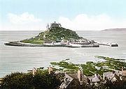
, WalesWalesWales is a country that is part of the United Kingdom and the island of Great Britain, bordered by England to its east and the Atlantic Ocean and Irish Sea to its west. It has a population of three million, and a total area of 20,779 km²... - St Michael's MountSt Michael's MountSt Michael's Mount is a tidal island located off the Mount's Bay coast of Cornwall, United Kingdom. It is a civil parish and is united with the town of Marazion by a man-made causeway of granite setts, passable between mid-tide and low water....
in CornwallCornwallCornwall is a unitary authority and ceremonial county of England, within the United Kingdom. It is bordered to the north and west by the Celtic Sea, to the south by the English Channel, and to the east by the county of Devon, over the River Tamar. Cornwall has a population of , and covers an area of...
, Great Britain - St Mary's IslandSt Mary's Island, Tyne and WearSt. Mary's Island is a small island made of sandstone near the seaside resort of Whitley Bay, Tyne and Wear, UK.St. Mary's Island was originally called Bates Island, Hartley Bates or Bates Hill as it was originally owned by the Bates family who were prominent locally. It is sometimes known as Bait...
in North TynesideNorth TynesideThe Metropolitan Borough of North Tyneside is a metropolitan borough of Tyne and Wear, in North East England and is part of the Tyneside conurbation. Its seat is Wallsend Town Hall....
, England - Sully IslandSully IslandSully Island is a small tidal island at the hamlet of Swanbridge, Vale of Glamorgan, four hundred and fifty metres off the northern coast of the Bristol Channel, midway between the towns of Penarth and Barry and 7 miles south of the Welsh capital city of Cardiff...
in the Vale of GlamorganVale of GlamorganThe Vale of Glamorgan is a county borough in Wales; an exceptionally rich agricultural area, it lies in the southern part of Glamorgan, South Wales...
, Wales - Worm's Head at the end of GowerGower PeninsulaGower or the Gower Peninsula is a peninsula in south Wales, jutting from the coast into the Bristol Channel, and administratively part of the City and County of Swansea. Locally it is known as "Gower"...
, Wales
43 tidal islands can be walked to from the UK mainland.
Canada
- Minister's IslandMinister's IslandMinisters Island is an historic Canadian island in New Brunswick's Passamaquoddy Bay near the town of St. Andrews.The island stands several hundred metres offshore immediately northeast of the town and is a geographical novelty in that it is accessible at low tide by a wide gravel bar suitable for...
in New BrunswickNew BrunswickNew Brunswick is one of Canada's three Maritime provinces and is the only province in the federation that is constitutionally bilingual . The provincial capital is Fredericton and Saint John is the most populous city. Greater Moncton is the largest Census Metropolitan Area...
, CanadaCanadaCanada is a North American country consisting of ten provinces and three territories. Located in the northern part of the continent, it extends from the Atlantic Ocean in the east to the Pacific Ocean in the west, and northward into the Arctic Ocean... - Micou's IslandMicou's Island, Nova ScotiaMicou's Island is a tidal island located in the Glen Haven community near the eastern shore of St. Margarets Bay, Nova Scotia, Canada. The island is accessible by a sandbar at low tide and has become a popular beach during summer months....
in St. Margarets BaySt. Margarets Bay, Nova ScotiaSt. Margarets Bay is a Canadian bay located on the Atlantic coast of Nova Scotia on the border of the Halifax Regional Municipality and Lunenburg County .-Description:...
, Nova ScotiaNova ScotiaNova Scotia is one of Canada's three Maritime provinces and is the most populous province in Atlantic Canada. The name of the province is Latin for "New Scotland," but "Nova Scotia" is the recognized, English-language name of the province. The provincial capital is Halifax. Nova Scotia is the...
, CanadaCanadaCanada is a North American country consisting of ten provinces and three territories. Located in the northern part of the continent, it extends from the Atlantic Ocean in the east to the Pacific Ocean in the west, and northward into the Arctic Ocean...
United States
- Bar IslandBar IslandBar island is a tidal island across from Bar Harbor on Mount Desert Island , Maine, United States. The uninhabited island forested mostly in pine and birch is now part of Acadia National Park. There are walking trails on the island....
in MaineMaineMaine is a state in the New England region of the northeastern United States, bordered by the Atlantic Ocean to the east and south, New Hampshire to the west, and the Canadian provinces of Quebec to the northwest and New Brunswick to the northeast. Maine is both the northernmost and easternmost...
, U.S.A. - High Island, New YorkHigh Island, New YorkHigh Island is a small private island, part of The Pelham Islands group in the New York City borough of the Bronx. It lies east of the north end of City Island between City Island Harbor and Pelham Bay in Long Island Sound. It is an island at most times, but is connected to City Island by a sandbar...
- Long Point Island, Harpswell, MaineHarpswell, MaineHarpswell is a town in Cumberland County, Maine, which is geographically within Casco Bay in the Gulf of Maine. The population was 5,239 at the 2000 census. Harpswell is composed of land contiguous with the rest of Cumberland County, called Harpswell Neck, as well as several large and small...
, U.S.A. - Cana Island LighthouseCana Island LighthouseThe Cana Island lighthouse is a lighthouse located just north of Baileys Harbor in Door County, Wisconsin.Currently used as an active navigational aid under the jurisdiction of the United States Coast Guard and a museum, it was added to the National Register of Historic Places in 1976, as reference...
in WisconsinWisconsinWisconsin is a U.S. state located in the north-central United States and is part of the Midwest. It is bordered by Minnesota to the west, Iowa to the southwest, Illinois to the south, Lake Michigan to the east, Michigan to the northeast, and Lake Superior to the north. Wisconsin's capital is...
, U.S.A. - Battery Point LightBattery Point LightBattery Point Light is a lighthouse in Crescent City, California, United States. It is registered as California Historical Landmark number 951.-History:...
in CaliforniaCaliforniaCalifornia is a state located on the West Coast of the United States. It is by far the most populous U.S. state, and the third-largest by land area...
, U.S.A. - Camano IslandCamano IslandCamano Island is a large island in the Possession Sound portion of Puget Sound, located in Island County, Washington, between Whidbey Island and the mainland. The body of water separating Whidbey Island and Camano Island is called Saratoga Passage. Camano Island is separated from mainland...
in Puget SoundPuget SoundPuget Sound is a sound in the U.S. state of Washington. It is a complex estuarine system of interconnected marine waterways and basins, with one major and one minor connection to the Strait of Juan de Fuca and the Pacific Ocean — Admiralty Inlet being the major connection and...
of Washington, U.S.A., since earth filled - Douglas IslandDouglas IslandDouglas Island is a tidal island in the U.S. state of Alaska, just west of downtown Juneau and east of Admiralty Island. It is separated from mainland Juneau by the Gastineau Channel. The Juneau-Douglas Bridge, connecting the island with Juneau, provides a two lane road to and from the island and...
in AlaskaAlaskaAlaska is the largest state in the United States by area. It is situated in the northwest extremity of the North American continent, with Canada to the east, the Arctic Ocean to the north, and the Pacific Ocean to the west and south, with Russia further west across the Bering Strait...
, USA
New Zealand
- Matakana IslandMatakana IslandMatakana Island is located in the western Bay of Plenty in New Zealand's North Island. A long, flat island, it is in length but rarely more than wide. The island has been continuously populated for centuries by a number Māori tribes that are mostly associated with Ngai Te Rangi...
in TaurangaTaurangaTauranga is the most populous city in the Bay of Plenty region, in the North Island of New Zealand.It was settled by Europeans in the early 19th century and was constituted as a city in 1963...
Harbour - Rabbit Island, Bells Island, Bests Island, and Pepin Island in Tasman BayTasman BayTasman Bay is a large V-shaped bay at the north end of New Zealand's South Island. Located in the centre of the island's northern coast, it stretches along of coastline and is across at its widest point. It is an arm of the Tasman Sea, lying on the western approach to Cook Strait.At the bay's...
- Puddingstone Island in Otago HarbourOtago HarbourOtago Harbour is the natural harbour of Dunedin, New Zealand, consisting of a long, much-indented stretch of generally navigable water separating the Otago Peninsula from the mainland. They join at its southwest end, from the harbour mouth...
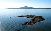
- The Hauraki GulfHauraki GulfThe Hauraki Gulf is a coastal feature of the North Island of New Zealand. It has a total area of 4000 km², and lies between the Auckland Region, the Hauraki Plains, the Coromandel Peninsula and Great Barrier Island...
islands of Motutapu IslandMotutapu IslandMotutapu Island is a island in the Hauraki Gulf to the northeast of the city of Auckland, New Zealand. The island is part of the Hauraki Gulf Maritime Park....
and Rangitoto IslandRangitoto IslandRangitoto Island is a volcanic island in the Hauraki Gulf near Auckland, New Zealand. The 5.5 km wide island is an iconic and widely visible landmark of Auckland with its distinctive symmetrical shield volcano cone rising 260 metres high over the Hauraki Gulf...
are connected at low tide - Opahekeheke Island in the Kaipara HarbourKaipara HarbourKaipara Harbour is a large enclosed harbour estuary complex on the north western side of the North Island of New Zealand. The northern part of the harbour is administered by the Kaipara District and the southern part is administered by the Rodney District...
- The Okatakata Islands and Walker Island in Rangaunu HarbourRangaunu HarbourRangaunu Harbour is a shallow harbour in the far north of New Zealand. It is situated on the east coast at the base of the Aupouri Peninsula. The name in Māori means "To pull out a shoal of fish". With an area of it is the fifth-largest harbour in New Zealand....