

U.S. Route 1 in Maryland
Encyclopedia
U.S. Route 1 is the easternmost and longest of the major north–south routes of the United States Numbered Highway System, running from Key West, Florida
to Fort Kent, Maine
. In the U.S. state
of Maryland
, it is an 80.86 miles (130.13 km) segment of the route that runs through central Maryland between Mount Rainier
and Rising Sun
.
US 1 is paralleled by several major highways as it passes through Maryland, including Interstate 95
, the Baltimore–Washington Parkway, U.S. Route 29
and U.S. Route 301
. Thus, US 1 has lost its significance as a long distance route through the state. It is often congested, however, because it remains a major route in the individual towns it traverses.
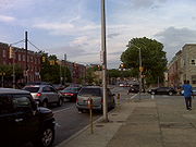
as Rhode Island Avenue, a four-lane divided street with parking through a downtown-like commercial area. US 1 meets 34th Avenue and Perry Street at a roundabout, then continues northeast through a densely-populated residential area. The highway leaves Mount Rainier and enters Brentwood, where the highway meets MD 208
(38th Street). US 1 passes through North Brentwood as a four-lane divided highway without parking through a mix of residences and commercial establishments. The median widens as the highway crosses Northwest Branch
and enters the town of Hyattsville. The highway begins to closely parallel CSX
's Capital Subdivision and MARC
's Camden Line
as it reduces to a four-lane undivided highway, passing Prince George's District Court. US 1 curves to the north and the highway's name changes to Baltimore Avenue at Farragut Street, shortly before intersecting US 1 Alternate.
US 1 continues north through downtown Hyattsville, gaining a center turn lane before entering the town of Riverdale Park, where the highway intersects MD 410
(East–West Highway). The highway enters a densely-populated residential area, passing between Riverdale Park to the east and the town of University Park to the west. Shortly after the highway enters the town of College Park on the east, US 1 intersects Queens Chapel Road at a five-way intersection. Only buses may enter Queens Chapel Road from US 1. The highway fully enters College Park and enters the commercial area that makes up the downtown of the college town, expanding to a four-lane divided highway. After the intersection with College Avenue and Regents Drive, US 1 passes through the campus of the University of Maryland, College Park, including the historic Rossborough Inn
and Fraternity Row. The highway leaves the campus after intersecting Campus Drive and Paint Branch Parkway and crossing Paint Branch
.
US 1 continues through the northern part of College Park as a five-lane road with center turn lane, passing through a suburban commercial area. The highway intersects Greenbelt Road, which is unsigned MD 430, before meeting MD 193
(University Boulevard) at a partial interchange. All movements not provided in the interchange require using Greenbelt Road to connect between US 1 and MD 193. After intersecting Cherry Hill Road, US 1 becomes a divided highway and meets the Interstate 495 (Capital Beltway) (I-95
and I-495) at a partial cloverleaf interchange. North of the interchange, the highway expands to a six-lane divided highway, leaving the town of College Park and passing by an Ikea
store and through a swath of the Beltsville Agricultural Research Center, including the National Agricultural Library
.
At Sunnyside Avenue, the highway reduces to a five-lane road with center turn lane and passes through a suburban commercial area in the unincorporated town of Beltsville. The highway meets Rhode Island Avenue at an oblique intersection and MD 212
(Powder Mill Road) at a more orthogonal intersection before curving north and paralleling CSX's Capital Subdivision. The highway passes between a commercial strip on the southbound side of the highway and an industrial area on the east side of the railroad tracks. US 1 leaves Beltsville after crossing Indian Creek. The highway temporarily expands to a four-lane divided highway before returning to a five-lane road, passing between an industrial area to the east and office parks to the west. After Miurkirk Meadows Drive, which leads to Miurkirk Road, US 1 reduces to a four-lane undivided highway, passes under the latter highway, and enters a forested area.
US 1 gradually veers away from the railroad tracks as it approaches Laurel, passing Maryland National Memorial Park before entering a suburban commercial area ahead of Contee Road, where the center turn lane returns. At Cypress Street, the southbound direction gains a third lane through the intersection with Cherry Lane, where the northbound direction gains a third lane. After passing Laurel Mall and Laurel Shopping Center
, US 1 splits into a one-way pair. The three to four northbound lanes veer northeast as Second Street, while the three to four southbound lanes take the name Washington Boulevard. The one-way pair intersects Bowie Road, the old alignment of MD 197
, before intersecting MD 198
, which takes the form of a one-way pair, eastbound Gorman Avenue and westbound Talbott Avenue. US 1 continues through the city of Laurel, intersecting Main Street just west of the Laurel MARC Station
before leaving Laurel by crossing the Patuxent River
into Howard County.
North of Jessup, US 1 crosses Deep Run and passes more industrial parks. The highway intersects MD 103 (Meadowridge Road) and passes Meadow Ridge Memorial Park before a partial cloverleaf interchange with MD 100 near Dorsey. Continuing northeast past Bealmear Branch, Old Washington Road splits to the northeast to pass through the center of Elkridge shortly before US 1 intersects the old alignment of MD 103, Montgomery Road. The highway passes through a shallow S-curve before receiving the other end of Old Washington Road and passes under the Capital Subdivision. US 1's two directions become divided by a Jersey barrier as the highway passes through the commercial strip in Elkridge, passing ramps to and from I-895 (Harbor Tunnel Thruway) immediately before crossing the Patapsco River into Baltimore County.
 After passing under I-895, US 1 intersects South Street, which provides access to St. Denis and Relay, and passes through its interchange with I-195 (Metropolitan Boulevard). The undivided highway crosses over CSX's Baltimore Terminal Subdivision before reaching the partial interchange with US 1 Alternate. Washington Boulevard continues straight northeast as US 1 Alternate through Halethorpe, while US 1 exits onto Southwestern Boulevard to head north through Arbutus. The three-lane road with center turn lane and extra-wide shoulders parallels the Amtrak Northeast Corridor
and MARC's Penn Line
. After crossing Herbert Run, US 1 parallels the long, linear parking lot of the Halethorpe MARC station. The highway leaves the station after passing under Francis Avenue. US 1 expands to a five-lane road with center turn lane as it crosses under I-95.
US 1 passes under Sulphur Spring Road and I-695 (Baltimore Beltway) as the highway heads out of Arbutus. The only connection with I-695 is a single ramp, Exit 12A, from I-695 east to US 1 south. Inside the Beltway, US 1 is paralleled by Leeds Avenue, which intersects the federal highway just before entering the city of Baltimore.
US 1 continues north as a four-lane divided street through a densely-populated residential area. A short distance north of the city line, US 1 curves to the east onto Wilkens Avenue, which continues west as MD 372. The highway crosses the Amtrak Northeast Corridor and reduces to an undivided highway, intersecting US 1 Alternate (Caton Avenue) as it passes through a curve. US 1 crosses Gwynns Falls and expands to a divided highway before passing the Deck of Cards rowhouses between Brunswick Street and Millington Avenue. A short distance to the east, US 1 turns north onto a one-way pair, Monroe Street southbound and Fulton Avenue northbound, to pass through a densely-populated residential area on the west side of central Baltimore. US 1 meets the eastern terminus of MD 144 at another one-way pair, Pratt Street and Lombard Street. The highway passes over the US 40 freeway, which is accessed by the one-way pair adjacent to the freeway, Mulberry Street and Franklin Street. At Edmondson Avenue, Fulton Avenue becomes two-way; however, southbound US 1 remains on Monroe Street. Shortly after passing over the Amtrak Northeast Corridor, US 1 reaches North Avenue. The Fulton Avenue/Monroe Street one-way pair continues north as MD 140, while both directions of US 1 turn east onto North Avenue.
North Avenue heads east as a four-lane undivided highway through the junction with MD 129, which follows southbound Druid Hill Avenue and northbound McCulloh Street. US 1 continues east as a four-lane divided highway with parking lanes. The highway meets I-83 (Jones Falls Expressway) and Mount Royal Avenue next to the North Avenue station of the Baltimore Light Rail. US 1 expands to six lanes and crosses over the light rail tracks, Jones Falls, Falls Road, and CSX's Baltimore Terminal Subdivision. Due north of downtown Baltimore, North Avenue intersects Charles Street (MD 139 to the north), St. Paul and Calvert Streets (MD 2 to the south), and Greenmount Avenue (MD 45 to the north), after which North Avenue passes along the north side of Greenmount Cemetery. North Avenue reduces to a four-lane undivided street east of MD 45. Shortly after intersecting MD 147 (Harford Road) and Broadway, US 1 turns northeast onto Bel Air Road.
US 1 heads northeast as a four-lane undivided road, crossing the Baltimore Terminal Subdivision again and passing Clifton Park before reaching Erdman Avenue, which heads southeast as MD 151. The highway crosses Herring Run before intersecting Moravia Road, where Bel Air Road transitions from passing through densely-populated residential neighborhoods to being the center of a commercial strip. US 1 intersects Frankford Avenue and Hamilton Avenue before leaving the city of Baltimore at Fleetwood Avenue, which forms the eastbound component of a one-way pair with Northern Parkway at the latter street's eastern terminus. US 1 passes through the inner suburb of Overlea, crossing Stemmers Run before meeting I-695 (Baltimore Beltway) at a cloverleaf interchange.
US 1 continues northeast from the Beltway as a six-lane divided highway. The highway intersects Rossville Boulevard and Putty Hill Road then crosses MD 43 (White Marsh Boulevard). US 1 accesses MD 43 via connectors with a right-in/right-out
interchange southbound and an intersection with Dunfield Road northbound. North of MD 43, US 1 reduces to a four-lane undivided highway as it passes through Perry Hall, intersecting Silver Spring Road, Joppa Road, and Ebenezer Road in the midst of a commercial strip. After the intersection with Honeygo Boulevard, US 1 descends into a steep valley to cross Gunpowder Falls. The highway continues north through a mix of farmland and residential subdivisions, heading through Kingsville before passing through Gunpowder Falls State Park and leaving Baltimore County by crossing Little Gunpowder Falls.
US 1 continues northeast as Conowingo Road through farmland. The old alignment of US 1, Forge Hill Road, splits to the east in Kalmia and rejoins the present highway 3 miles (4.8 km) later after separate crossings of Deer Creek. The highway passes through a commercial strip around the intersectin with MD 136 (Whiteford Road/Priestford Road) as US 1 passes to the south of Dublin. US 1 curves east at the intersection with MD 440 (Dublin Road). Smith Road, another old alignment of US 1, splits to the northeast as US 1 heads toward Darlington, where it meets MD 161 (Main Street) and MD 623 (Castleton Road). The highway heads straight over a series of hills, gaining climbing lanes in either direction. At Shuresville Road, US 1 curves to the northeast and crosses the Susquehanna River on top of Conowingo Dam.
In the early 19th century, many of these dirt roads were reconstructed as turnpikes. The Washington Turnpike was chartered in 1796, but no road building ever occurred. It was not until the Washington and Baltimore Turnpike was chartered in 1812 that construction began along a 60 feet (18.3 m) right of way between the corner of Pratt and Eutaw Streets, then at the western city limit of Baltimore, southwest along the old dirt road to the District of Columbia boundary southwest of Bladensburg. In 1817, a timber toll bridge replaced Norwood's Ferry in Elkridge. The Washington and Baltimore Turnpike had its chartered revoked in 1865 and the highway was turned over to the counties. The toll bridge at Elkridge was sold to the counties in 1869.
By 1825, a turnpike existed from Baltimore toward Bel Air. The Bel Air Turnpike was constructed from the Baltimore city line at the corner of North Avenue and Gay Street through Perry Hall and Kingsville to a junction with the Harford Turnpike at Benson in Harford County. From Benson, the Bel Air Turnpike of Harford County continued east to Main Street in Bel Air. North of Bel Air, what is now US 1 followed county highways to the Conowingo Bridge, which was first constructed around 1820.
By 1910, the Baltimore–Washington Boulevard was paved from the District of Columbia boundary southwest of Bladensburg north to Beltsville, with small gaps at Northeast Branch south of Hyattsville and at Paint Branch in College Park; from Contee to Elkridge; and from Hammonds Ferry Road in Halethorpe to the Baltimore city line at Gwynns Falls. The Maryland General Assembly appropriated another $120000 in 1910 for the newly-formed Maryland State Roads Commission to complete the Baltimore–Washington Boulevard. By 1915, State Route No. 1 was completely paved with the addition of the highway on a new alignment between Beltsville and Contee, the filling of the gaps in College Park and Hyattsville, and construction between Elkridge and Halethorpe. The road was constructed a minimum of 14 feet (4.3 m) in width with macadam, gravel, and concrete, with curves reduced and grades straightened. Concrete sections in Laurel, College Park, and Bladensburg were among the first concrete roads in Maryland when they were poured in 1912. Concrete girder bridges were built at Northeast Branch and the Anacostia River in Bladensburg. A concrete bridge was built over the Patapsco River at Elkridge to replace an iron bridge. Due to heavy traffic and inadequate initial construction, many of the sections constructed in the first few years of state aid had to be rebuilt.
Massive increases in traffic during the 1920s made the reconstruction of the late 1910s obsolete within the decade. Construction to expand the entire length of the Baltimore–Washington Boulevard with two 10 feet (3 m) shoulders to 40 feet (12.2 m) in width, allowing for four lanes, began in 1928. The final sections of the expanded highway, between the DC line and Bladensburg and a bypass of Elkridge, including the present underpass of the B&O Railroad, were completed in 1931. The old road through Elkridge was designated MD 477.
US 1's first major relocation north of Baltimore occurred at the Susquehanna River. The Conowingo Bridge was removed before it could be inundated by the Conowingo Reservoir set to fill upon the completion of Conowingo Dam in 1928. The old approaches, which consisted of Smith Road from near Darlington to Glen Cove on the west side of the river and Connelly Road, Ragan Road, and Old Conowingo Road to the mouth of Conowingo Creek on the east side of the river, were replaced with the present highway between Smith Road and Connelly Road. Smith Road was redesignated MD 162, while the eastern approach became a western extension of MD 273.
US 1 saw three realignments north of Baltimore in 1934. A 3 miles (4.8 km) relocation near Kalmia included a new bridge over Deer Creek. The old highway, which featured 26 curves, was designated MD 590. Another relocation occurred between Conowingo and Rising Sun, featuring a new bridge over Octoraro Creek. The old highway was designated MD 591. East of Rising Sun, a 90-degree turn was bypassed at the intersection of Telegraph Road (now MD 273) and Sylmar Road by the construction of a sweeping curve to the northwest of the intersection. The bypassed portion of Sylmar Road was designated MD 592.
Bel Air Road was expanded started in 1933. US 1 was widened to 40 feet (12.2 m) from the Baltimore city line northeast to Joppa Road. The highway was widened to 30 feet (9.1 m) from Joppa Road to Bel Air. The 30 feet (9.1 m) road was the first construction in Maryland of a three-lane road with center turn lane.
In 1939, US 1's departure north from Washington Boulevard in Baltimore was moved south from Monroe Street to Caton Avenue just north of the city line. From Caton Avenue, US 1 followed Wilkens Avenue to Monroe Street. Caton Avenue and Wilkens Avenue were expanded between 1936 and 1938, including removal of streetcar tracks and expansion to a divided boulevard on Wilkens Avenue, to handle the increased traffic as a "through-street." By 1946, a Bypass US 1 was signed following Caton Avenue north from Wilkens Avenue, continuing on Hilton Street to North Avenue, then taking North Avenue east to rejoin US 1 at Monroe Street. Southwestern Boulevard was completed in 1950 as a dual highway through Arbutus, with grade separations with Sulphur Spring Road and Francis Avenue. US 1 was moved to its present alignment along that boulevard and Wilkens Avenue and old US 1 through Halethorpe was designated US 1 Alternate.
During World War II, US 1 was relocated from Baltimore Avenue and Bladensburg Road between Washington and Hyattsville to Rhode Island Avenue, which was widened to 36 feet (11 m) in 1940. Rhode Island Avenue between Mount Rainier and Hyattsville had originally been MD 411. The old US 1 south of Hyattsville became US 1 Alternate. Despite these relocations and upgrades, true relief did not come until the first limited-access highway between Baltimore and Washington, the Baltimore–Washington Parkway, was completed in 1954 to remove long distance traffic from US 1. With the completion of that highway and later the Harbor Tunnel Thruway (I-895) and I-95, US 1 between the two cities became a highway mainly for local traffic.
!County
!Location
!Mile
!Destinations
!Notes
|-
|rowspan=19|Prince George's
|rowspan=3|Mount Rainier
|rowspan=2|0.00
|
|rowspan=2|District of Columbia boundary
|-
|Eastern Avenue
|-
|0.16
|34th Street / Perry Street
|Roundabout; 34th Street is old alignment of MD 208
|-
|rowspan=1|Brentwood
|0.48
|
|
|-
|rowspan=1|Hyattsville
|1.82
|
|
|-
|rowspan=1|Riverdale Park
|2.61
|
|
|-
|rowspan=1|University Park
|3.20
|Queens Chapel Road south / Pineway west / Amherst Road east
|Queens Chapel Road is former MD 500; no entry to Queens Chapel Road except buses
|-
|rowspan=5|College Park
|3.83
|College Avenue east / Regents Drive north – University of Maryland, College Park
|College Avenue is former MD 203
|-
|4.32
|Paint Branch Parkway east / Campus Drive west – University of Maryland, College Park
|
|-
|5.03
|
|MD 430 is unsigned
|-
|5.24
| – University of Maryland, College Park
, Langley Park
|Partial cloverleaf interchange
|-
|6.43
|
|I-95/I-495 Exit 25; partial cloverleaf interchange
|-
|rowspan=1|Beltsville
|8.00
|
|
|-
|rowspan=6|Laurel
|style="background:#ffdead"|
|style="background:#ffdead"|
|style="background:#ffdead"|Construction expected to begin in January 2012; interchange expected to open in 2014
|-
|13.14
|colspan=2 align=center|US 1 splits into one-way pair: Second Street northbound and Washington Boulevard southbound
|-
|13.40
|Bowie Road
|Old alignment of MD 197
|-
|13.49
|
|
|-
|13.58
|
|
|-
|13.99
|Main Street
|Main Street between the one-way pair is unsigned MD 979
|-
|colspan=2|
|14.12
|colspan=2 align=center|Bridge over Patuxent River
|-
|rowspan=11|Howard
|rowspan=2|North Laurel
|
|colspan=2 align=center|US 1 rejoins from one-way pair: Washington Boulevard southbound and Second Street northbound
|-
|
|Whiskey Bottom Road
– Maryland City
|
|-
|rowspan=2|Savage
|
|
|MD 32 Exit 12; cloverleaf interchange
|-
|
|Guilford Road – Annapolis Junction
|Former MD 732
|-
|rowspan=1|Jessup
|
|
|
|-
|rowspan=2|Dorsey
|
|
|
|-
|
|
|MD 100 Exit 6; partial cloverleaf interchange
|-
|rowspan=4|Elkridge
|
|Old Washington Road north
|Former MD 477; old alignment of US 1
|-
|
|Montgomery Road
|Old alignment of MD 103; Montgomery Road eastbound is unsigned MD 103A
|-
|
|Old Washington Road south
|Former MD 477; old alignment of US 1
|-
|
|
|I-895 Exit 1; northbound exit and southbound entrance
|-
|colspan=2|
|25.13
|colspan=2 align=center|Bridge over Patapsco River
|-
|rowspan=2|Baltimore County
|rowspan=2|Arbutus
|
|
|I-195 Exit 3
|-
|
|
|Northbound exit and southbound entrance
|-
|rowspan=19 colspan=2|Baltimore City
|
|
|US 1 turns onto Wilkens Avenue
|-
|
| / Caton Avenue north
|
|-
|
|Monroe Street
|US 1 splits into one-way pair: Monroe Street is southbound US 1
|-
|
|Fulton Avenue
|US 1 northbound turns north onto Fulton Avenue
|-
|
|Pratt Street
|
|-
|
|
|
|-
|
|Mulberry Street to
|
|-
|
|Franklin Street to
|
|-
|
| / North Avenue west
|US 1 rejoins from one-way pair; US 1 turns east onto North Avenue
|-
|
|
|
|-
|
|
|
|-
|
| / Mount Royal Avenue south
|I-83 Exit 6
|-
|
|
|
|-
|
|
|
|-
|.00
|Calvert Street north
|
|-
|
| / Greenmount Avenue south
|
|-
|
| / Harford Avenue south
|
|-
|
|Gay Street south / North Avenue east
|US 1 turns north onto Bel Air Road
|-
|
| / Erdman Avenue north
|
|-
|rowspan=4|Baltimore
|rowspan=3|Overlea
|
|
|I-695 Exit 32; cloverleaf interchange
|-
|
|
|Right-in/right-out interchange with southbound US 1
|-
|
| / Dunfield Road west
|Northbound US 1 access to MD 43
|-
|rowspan=1|Perry Hall
|
|Joppa Road west / Ebenezer Road east
|Joppa Road is former MD 148
|-
|colspan=2|
|51.65
|colspan=2 align=center|Bridge over Little Gunpowder Falls
|-
|rowspan=16|Harford
|rowspan=2|Benson
|.00
|
|
|-
|
|
|
|-
|rowspan=3|Bel Air North
|
|
|South end of concurrency with MD 24
|-
|0
|
|North end of concurrency with MD 24; partial cloverleaf interchange
|-
|0
|
|
|-
|rowspan=3|Hickory
|
|
|
|-
|
|
|
|-
|
|
|
|-
|rowspan=2|Kalmia
|
|Forge Hill Road north
|rowspan=2|Old alignment of US 1
|-
|
|Forge Hill Road south
|-
|rowspan=2|Dublin
|
|
|
|-
|
|
|
|-
|rowspan=4|Darlington
|
|Smith Road east
|Former MD 162; old alignment of US 1
|-
|
|
|
|-
|
|
|
|-
|
|Shuresville Road
|Former MD 160
|-
|-
|colspan=2|
|71.63
|colspan=2 align=center|Conowingo Dam
– Susquehanna River
|-
|rowspan=7|Cecil
|rowspan=2|Conowingo
|
|
|South end of concurrency with MD 222
|-
|
| / Rowlandsville Road south – Oakwood
, Lancaster
|North end of concurrency with MD 222, south end of concurrency with MD 222 Truck, Rowlandsville Road is former MD 338
|-
|rowspan=2|
|
| / Connelly Road north
|Officially MD 591A, which is old alignment of US 1; Connelly Road is former MD 273 and old alignment of US 1
|-
|
|
|Officially MD 591B; old alignment of US 1
|-
|rowspan=3|Rising Sun
|
| – Newark, DE
|Old alignment of US 1
|-
|
|
|North end of concurrency with MD 222 Truck
|-
|
| – Oxford, PA
, Philadelphia
|Pennsylvania state line
Key West, Florida
Key West is a city in Monroe County, Florida, United States. The city encompasses the island of Key West, the part of Stock Island north of U.S. 1 , Sigsbee Park , Fleming Key , and Sunset Key...
to Fort Kent, Maine
Fort Kent, Maine
Fort Kent is a town in Aroostook County, Maine, United States. The population was 4,097 in the 2010 census. Fort Kent is home to an Olympic biathlete training center, an annual CAN-AM dogsled race, and the Fort Kent Blockhouse, built in reaction to the Aroostook War and in modern times designated...
. In the U.S. state
U.S. state
A U.S. state is any one of the 50 federated states of the United States of America that share sovereignty with the federal government. Because of this shared sovereignty, an American is a citizen both of the federal entity and of his or her state of domicile. Four states use the official title of...
of Maryland
Maryland
Maryland is a U.S. state located in the Mid Atlantic region of the United States, bordering Virginia, West Virginia, and the District of Columbia to its south and west; Pennsylvania to its north; and Delaware to its east...
, it is an 80.86 miles (130.13 km) segment of the route that runs through central Maryland between Mount Rainier
Mount Rainier, Maryland
Mount Rainier is a city in Prince George's County, Maryland, United States. The population was 8,498 at the 2000 census. Bordering Washington, DC, Mount Rainier got its start as a streetcar suburb. According to local tradition, surveyors from the Pacific Northwest named the town, giving the...
and Rising Sun
Rising Sun, Maryland
Rising Sun is a town in Cecil County, Maryland, United States. The population was 1,702 at the 2000 census.-Overview:Rising Sun is located at ....
.
US 1 is paralleled by several major highways as it passes through Maryland, including Interstate 95
Interstate 95 in Maryland
Interstate 95 in Maryland is a major highway that runs diagonally from northeast to southwest, from Maryland's border with Delaware, to the Woodrow Wilson Bridge, briefly entering the District of Columbia before reaching Virginia...
, the Baltimore–Washington Parkway, U.S. Route 29
U.S. Route 29 in Maryland
U.S. Route 29 is a north–south United States highway that runs for from the western suburbs of Baltimore, Maryland, to Pensacola, Florida. In the U.S. state of Maryland, US 29 is a major highway that emerges from Washington D.C. and runs north into eastern Montgomery County, stretching...
and U.S. Route 301
U.S. Route 301 in Maryland
U.S. Route 301 in Maryland is a major highway that runs from Delaware to the Governor Harry W. Nice Memorial Bridge into Virginia. It passes through three of Maryland's four main regions: the Eastern Shore, the Baltimore-Washington Metropolitan Area, and Southern Maryland...
. Thus, US 1 has lost its significance as a long distance route through the state. It is often congested, however, because it remains a major route in the individual towns it traverses.
Prince George's County
US 1 leaves the District of Columbia and enters Maryland at the town of Mount Rainier. The highway heads northeast from Eastern AvenueEastern Avenue (Washington, D.C.)
Eastern Avenue is one of three boundary streets between Washington, D.C., and the state of Maryland. It follows a northwest-to-southeast line, beginning at the intersection of 16th Street NW and Colesville Road...
as Rhode Island Avenue, a four-lane divided street with parking through a downtown-like commercial area. US 1 meets 34th Avenue and Perry Street at a roundabout, then continues northeast through a densely-populated residential area. The highway leaves Mount Rainier and enters Brentwood, where the highway meets MD 208
Maryland Route 208
Maryland Route 208 is a state highway in the U.S. state of Maryland. The route runs from U.S. Route 1 Alt in Cottage City north to Maryland Route 500 in Hyattsville.-Route description:...
(38th Street). US 1 passes through North Brentwood as a four-lane divided highway without parking through a mix of residences and commercial establishments. The median widens as the highway crosses Northwest Branch
Northwest Branch Anacostia River
Northwest Branch Anacostia River is a free-flowing stream in Montgomery County and Prince George's County, Maryland. It is a tributary of the Anacostia River, which flows to the Potomac River and the Chesapeake Bay.-Course:...
and enters the town of Hyattsville. The highway begins to closely parallel CSX
CSX Transportation
CSX Transportation operates a Class I railroad in the United States known as the CSX Railroad. It is the main subsidiary of the CSX Corporation. The company is headquartered in Jacksonville, Florida, and owns approximately 21,000 route miles...
's Capital Subdivision and MARC
MARC Train
MARC , known prior to 1984 as Maryland Rail Commuter Service, is a regional rail system comprising three lines in the Baltimore-Washington Metropolitan Area. MARC is administered by the Maryland Transit Administration , a Maryland Department of Transportation agency, and is operated under contract...
's Camden Line
Camden Line
The Camden Line is a MARC commuter rail line that runs between Union Station, Washington, D.C. and Camden Station, Baltimore, Maryland over the CSX Capital Subdivision. Service began along this route in 1835 as part of the Baltimore and Ohio Railroad , making it the oldest passenger rail line in...
as it reduces to a four-lane undivided highway, passing Prince George's District Court. US 1 curves to the north and the highway's name changes to Baltimore Avenue at Farragut Street, shortly before intersecting US 1 Alternate.
US 1 continues north through downtown Hyattsville, gaining a center turn lane before entering the town of Riverdale Park, where the highway intersects MD 410
Maryland Route 410
Maryland Route 410 is a state highway in the U.S. state of Maryland. Known for most of its length as East–West Highway, the highway runs from MD 355 in Bethesda east to Pennsy Drive in Landover Hills...
(East–West Highway). The highway enters a densely-populated residential area, passing between Riverdale Park to the east and the town of University Park to the west. Shortly after the highway enters the town of College Park on the east, US 1 intersects Queens Chapel Road at a five-way intersection. Only buses may enter Queens Chapel Road from US 1. The highway fully enters College Park and enters the commercial area that makes up the downtown of the college town, expanding to a four-lane divided highway. After the intersection with College Avenue and Regents Drive, US 1 passes through the campus of the University of Maryland, College Park, including the historic Rossborough Inn
The Rossborough Inn
The Rossborough Inn is a historic building on the campus of the University of Maryland, College Park. Construction on the building began in 1798 and was completed in 1812, making it the oldest building on campus and the oldest building in the City of College Park...
and Fraternity Row. The highway leaves the campus after intersecting Campus Drive and Paint Branch Parkway and crossing Paint Branch
Paint Branch
Paint Branch is a stream that flows through Montgomery County and Prince George's County, Maryland. It is a tributary of the Northeast Branch, which flows to the Anacostia River, Potomac River and the Chesapeake Bay....
.
US 1 continues through the northern part of College Park as a five-lane road with center turn lane, passing through a suburban commercial area. The highway intersects Greenbelt Road, which is unsigned MD 430, before meeting MD 193
Maryland Route 193
Maryland Route 193 is a state highway in the U.S. state of Maryland. Known for most of its length as University Boulevard and Greenbelt Road, the state highway runs from MD 185 in Kensington east to MD 202 in Greater Upper Marlboro...
(University Boulevard) at a partial interchange. All movements not provided in the interchange require using Greenbelt Road to connect between US 1 and MD 193. After intersecting Cherry Hill Road, US 1 becomes a divided highway and meets the Interstate 495 (Capital Beltway) (I-95
Interstate 95 in Maryland
Interstate 95 in Maryland is a major highway that runs diagonally from northeast to southwest, from Maryland's border with Delaware, to the Woodrow Wilson Bridge, briefly entering the District of Columbia before reaching Virginia...
and I-495) at a partial cloverleaf interchange. North of the interchange, the highway expands to a six-lane divided highway, leaving the town of College Park and passing by an Ikea
IKEA
IKEA is a privately held, international home products company that designs and sells ready-to-assemble furniture such as beds and desks, appliances and home accessories. The company is the world's largest furniture retailer...
store and through a swath of the Beltsville Agricultural Research Center, including the National Agricultural Library
United States National Agricultural Library
The United States National Agricultural Library is one of the world's largest agricultural research libraries, and serves as a National Library of the United States and as the library of the United States Department of Agriculture...
.
At Sunnyside Avenue, the highway reduces to a five-lane road with center turn lane and passes through a suburban commercial area in the unincorporated town of Beltsville. The highway meets Rhode Island Avenue at an oblique intersection and MD 212
Maryland Route 212
Maryland Route 212, also known as Riggs Road south of MD 193 and Powder Mill Road to its northern end, is a state highway which crosses northern Prince George's County.-Route description:...
(Powder Mill Road) at a more orthogonal intersection before curving north and paralleling CSX's Capital Subdivision. The highway passes between a commercial strip on the southbound side of the highway and an industrial area on the east side of the railroad tracks. US 1 leaves Beltsville after crossing Indian Creek. The highway temporarily expands to a four-lane divided highway before returning to a five-lane road, passing between an industrial area to the east and office parks to the west. After Miurkirk Meadows Drive, which leads to Miurkirk Road, US 1 reduces to a four-lane undivided highway, passes under the latter highway, and enters a forested area.
US 1 gradually veers away from the railroad tracks as it approaches Laurel, passing Maryland National Memorial Park before entering a suburban commercial area ahead of Contee Road, where the center turn lane returns. At Cypress Street, the southbound direction gains a third lane through the intersection with Cherry Lane, where the northbound direction gains a third lane. After passing Laurel Mall and Laurel Shopping Center
Laurel Shopping Center
Laurel Shopping Center is an open air shopping complex located in Laurel, Maryland, on U.S. Route 1 just south of Maryland Route 198, and is positioned next to Laurel Mall.-History:...
, US 1 splits into a one-way pair. The three to four northbound lanes veer northeast as Second Street, while the three to four southbound lanes take the name Washington Boulevard. The one-way pair intersects Bowie Road, the old alignment of MD 197
Maryland Route 197
Maryland Route 197 is a state highway in the U.S. state of Maryland. Known for most of its length as Laurel–Bowie Road, the state highway runs from U.S. Route 301 in Bowie north to MD 198 in Laurel. In addition to being the main connection between Bowie and Laurel, MD 197 provides access...
, before intersecting MD 198
Maryland Route 198
Maryland Route 198 is an east–west state highway in the central part of the U.S. state of Maryland that connects Fort Meade at Maryland Route 32 to Maryland Route 28 and Maryland Route 650 near Spencerville.-Spencerville Road:...
, which takes the form of a one-way pair, eastbound Gorman Avenue and westbound Talbott Avenue. US 1 continues through the city of Laurel, intersecting Main Street just west of the Laurel MARC Station
Laurel (MARC station)
Laurel is a historic passenger rail station on the MARC Camden Line in Laurel, Maryland, between Union Station in Washington, D.C. and Baltimore's Camden Station....
before leaving Laurel by crossing the Patuxent River
Patuxent River
The Patuxent River is a tributary of the Chesapeake Bay in the state of Maryland. There are three main river drainages for central Maryland: the Potomac River to the west passing through Washington D.C., the Patapsco River to the northeast passing through Baltimore, and the Patuxent River between...
into Howard County.
Howard County
Immediately after crossing the Patuxent River, both directions of US 1 pass entrances to Laurel Park Racecourse. The highway continues through North Laurel, with the one-way pair coming together shortly before the intersection with Whiskey Bottom Road. US 1 continues north as a five-lane road with center turn lane, crossing Hammond Branch. As the highway passes through a commercial area in Savage, the road becomes a divided highway. After Gorman Road, the roadways temporarily diverge to cross the Little Patuxent River, then come together again at the full cloverleaf interchange with MD 32 (Patuxent Freeway). US 1 becomes undivided and intersects Guilford Road and crosses over the Columbia Branch from the CSX Capital Subdivision to the east. The highway passes several industrial parks, crossing Dorsey Run twice before intersecting MD 175 (Waterloo Road) in Jessup.North of Jessup, US 1 crosses Deep Run and passes more industrial parks. The highway intersects MD 103 (Meadowridge Road) and passes Meadow Ridge Memorial Park before a partial cloverleaf interchange with MD 100 near Dorsey. Continuing northeast past Bealmear Branch, Old Washington Road splits to the northeast to pass through the center of Elkridge shortly before US 1 intersects the old alignment of MD 103, Montgomery Road. The highway passes through a shallow S-curve before receiving the other end of Old Washington Road and passes under the Capital Subdivision. US 1's two directions become divided by a Jersey barrier as the highway passes through the commercial strip in Elkridge, passing ramps to and from I-895 (Harbor Tunnel Thruway) immediately before crossing the Patapsco River into Baltimore County.
Baltimore City and County
Northeast Corridor
The Northeast Corridor is a fully electrified railway line owned primarily by Amtrak serving the Northeast megalopolis of the United States from Boston in the north, via New York to Washington, D.C. in the south, with branches serving other cities...
and MARC's Penn Line
Penn Line (MARC)
The Penn Line is a MARC commuter rail line running from Union Station, Washington D.C. to Perryville, Maryland via Penn Station, Baltimore, Maryland on Amtrak's Northeast Corridor. It is MARC's busiest and only electric line. Currently the line is the fastest commuter rail line in the country, with...
. After crossing Herbert Run, US 1 parallels the long, linear parking lot of the Halethorpe MARC station. The highway leaves the station after passing under Francis Avenue. US 1 expands to a five-lane road with center turn lane as it crosses under I-95.
US 1 passes under Sulphur Spring Road and I-695 (Baltimore Beltway) as the highway heads out of Arbutus. The only connection with I-695 is a single ramp, Exit 12A, from I-695 east to US 1 south. Inside the Beltway, US 1 is paralleled by Leeds Avenue, which intersects the federal highway just before entering the city of Baltimore.
US 1 continues north as a four-lane divided street through a densely-populated residential area. A short distance north of the city line, US 1 curves to the east onto Wilkens Avenue, which continues west as MD 372. The highway crosses the Amtrak Northeast Corridor and reduces to an undivided highway, intersecting US 1 Alternate (Caton Avenue) as it passes through a curve. US 1 crosses Gwynns Falls and expands to a divided highway before passing the Deck of Cards rowhouses between Brunswick Street and Millington Avenue. A short distance to the east, US 1 turns north onto a one-way pair, Monroe Street southbound and Fulton Avenue northbound, to pass through a densely-populated residential area on the west side of central Baltimore. US 1 meets the eastern terminus of MD 144 at another one-way pair, Pratt Street and Lombard Street. The highway passes over the US 40 freeway, which is accessed by the one-way pair adjacent to the freeway, Mulberry Street and Franklin Street. At Edmondson Avenue, Fulton Avenue becomes two-way; however, southbound US 1 remains on Monroe Street. Shortly after passing over the Amtrak Northeast Corridor, US 1 reaches North Avenue. The Fulton Avenue/Monroe Street one-way pair continues north as MD 140, while both directions of US 1 turn east onto North Avenue.
North Avenue heads east as a four-lane undivided highway through the junction with MD 129, which follows southbound Druid Hill Avenue and northbound McCulloh Street. US 1 continues east as a four-lane divided highway with parking lanes. The highway meets I-83 (Jones Falls Expressway) and Mount Royal Avenue next to the North Avenue station of the Baltimore Light Rail. US 1 expands to six lanes and crosses over the light rail tracks, Jones Falls, Falls Road, and CSX's Baltimore Terminal Subdivision. Due north of downtown Baltimore, North Avenue intersects Charles Street (MD 139 to the north), St. Paul and Calvert Streets (MD 2 to the south), and Greenmount Avenue (MD 45 to the north), after which North Avenue passes along the north side of Greenmount Cemetery. North Avenue reduces to a four-lane undivided street east of MD 45. Shortly after intersecting MD 147 (Harford Road) and Broadway, US 1 turns northeast onto Bel Air Road.
US 1 heads northeast as a four-lane undivided road, crossing the Baltimore Terminal Subdivision again and passing Clifton Park before reaching Erdman Avenue, which heads southeast as MD 151. The highway crosses Herring Run before intersecting Moravia Road, where Bel Air Road transitions from passing through densely-populated residential neighborhoods to being the center of a commercial strip. US 1 intersects Frankford Avenue and Hamilton Avenue before leaving the city of Baltimore at Fleetwood Avenue, which forms the eastbound component of a one-way pair with Northern Parkway at the latter street's eastern terminus. US 1 passes through the inner suburb of Overlea, crossing Stemmers Run before meeting I-695 (Baltimore Beltway) at a cloverleaf interchange.
US 1 continues northeast from the Beltway as a six-lane divided highway. The highway intersects Rossville Boulevard and Putty Hill Road then crosses MD 43 (White Marsh Boulevard). US 1 accesses MD 43 via connectors with a right-in/right-out
Right-in/right-out
Right-in/right-out and left-in/left-out refer to a type of road intersection where turning movements of vehicles are restricted. A RIRO permits only right turns and a LILO permits only left turns. RIRO is usual where vehicles drive on the right, and LILO is usual where vehicles drive on the left...
interchange southbound and an intersection with Dunfield Road northbound. North of MD 43, US 1 reduces to a four-lane undivided highway as it passes through Perry Hall, intersecting Silver Spring Road, Joppa Road, and Ebenezer Road in the midst of a commercial strip. After the intersection with Honeygo Boulevard, US 1 descends into a steep valley to cross Gunpowder Falls. The highway continues north through a mix of farmland and residential subdivisions, heading through Kingsville before passing through Gunpowder Falls State Park and leaving Baltimore County by crossing Little Gunpowder Falls.
Harford County
US 1 heads northeast into Harford County, passing through a forested area and then the residential subdivisions of Pleasant Hills before reaching MD 152 (Mountain Road). The highway continues east through a commercial strip toward the hamlet of Benson, where US 1 converges with MD 147 (Harford Road) at an acute angle. US 1 Business heads east from the intersection toward Bel Air, while US 1 continues northeast on the Bel Air Bypass. The bypass begins as a four-lane divided highway, but drops to a two-lane road before crossing Winters Run. US 1 intersects Tollgate Road, gaining a lane northbound, before meeting MD 24 (Vietnam Veterans Memorial Highway) at a T-intersection with sweeping right-turn ramps. MD 24 joins US 1 in a concurrency north on a four-lane undivided highway that passes under Vale Road. MD 24 leaves US 1 at a partial cloverleaf interchange with Rock Spring Avenue, which heads south as MD 924 toward downtown Bel Air. The bypass continues northeast with two lanes, its name changed to the Hickory Bypass before expanding to a four-lane divided highway and intersecting US 1 Business (Conowingo Road) south of Hickory. US 1 intersects the eastern end of MD 23 (East–West Highway) and MD 543 (Ady Road) before reducing to a two-lane road and receiving the northern end of US 1 Business.US 1 continues northeast as Conowingo Road through farmland. The old alignment of US 1, Forge Hill Road, splits to the east in Kalmia and rejoins the present highway 3 miles (4.8 km) later after separate crossings of Deer Creek. The highway passes through a commercial strip around the intersectin with MD 136 (Whiteford Road/Priestford Road) as US 1 passes to the south of Dublin. US 1 curves east at the intersection with MD 440 (Dublin Road). Smith Road, another old alignment of US 1, splits to the northeast as US 1 heads toward Darlington, where it meets MD 161 (Main Street) and MD 623 (Castleton Road). The highway heads straight over a series of hills, gaining climbing lanes in either direction. At Shuresville Road, US 1 curves to the northeast and crosses the Susquehanna River on top of Conowingo Dam.
Cecil County
On the east side of the river, US 1 passes over Norfolk Southern Railway's Columbia and Port Deposit Branch and immediately intersects MD 222 (Susquehanna River Road). The highway gains a climbing northbound as it ascends a hill to Conowingo, where the highway meets the southern terminus of US 222 (Rock Springs Road). US 1 turns east and meets a pair of old alignments: Connelly Road heading northwest and MD 591 (Colora Road) heading southeast toward a removed bridge over Octoraro Creek. After US 1 crosses the creek, the old alignment reconnects with the mainline as another segment of MD 591, Porters Bridge Road. West of Rising Sun, MD 273 (Rising Sun Road) continues straight toward the town while US 1 curves northeast as the Rising Sun Bypass. US 1 intersects MD 276 (Jacob Tome Memorial Highway) and crosses Stone Run twice before turning north to the Pennsylvania state line. The highway continues across the state line toward Oxford, Pennsylvania, becoming a four-lane divided highway just across the state line.Colonial and turnpike eras
The original predecessors of US 1 were a collection of dirt roads cut through the forests and farmland of central and northern Maryland in the 18th century. Construction of these roads was governed by a 1704 Act of the Province of Maryland requiring counties to oversee construction build 20 feet (6.1 m) wide roads to benefit transport of carts between population centers. The first segment of the road between Baltimore and Washington was built in 1741 between Baltimore and Elkridge as a southward extension of a road between Baltimore and Hanover, Pennsylvania. Passage across the Patapsco River at Elkridge was provided by Norwood's Ferry. In 1749, the road was blazed to Georgetown via Waterloo, Laurel, and Bladensburg. The highway north of Baltimore was a road constructed in the second half of the 18th century to connect the port of Baltimore with farms in Baltimore and Harford counties in Maryland and in Lancaster and Chester counties in Pennsylvania. From the docks in Baltimore, the road passed through Perry Hall and Kingsville on its way to Bel Air. The highway headed east from Bel Air to Churchville, then north to a crossing of the Susquehanna River at Conowingo. The road continued east to Rising Sun, then turned north toward Oxford, Pennsylvania, where the highway connected with roads to Philadelphia.In the early 19th century, many of these dirt roads were reconstructed as turnpikes. The Washington Turnpike was chartered in 1796, but no road building ever occurred. It was not until the Washington and Baltimore Turnpike was chartered in 1812 that construction began along a 60 feet (18.3 m) right of way between the corner of Pratt and Eutaw Streets, then at the western city limit of Baltimore, southwest along the old dirt road to the District of Columbia boundary southwest of Bladensburg. In 1817, a timber toll bridge replaced Norwood's Ferry in Elkridge. The Washington and Baltimore Turnpike had its chartered revoked in 1865 and the highway was turned over to the counties. The toll bridge at Elkridge was sold to the counties in 1869.
By 1825, a turnpike existed from Baltimore toward Bel Air. The Bel Air Turnpike was constructed from the Baltimore city line at the corner of North Avenue and Gay Street through Perry Hall and Kingsville to a junction with the Harford Turnpike at Benson in Harford County. From Benson, the Bel Air Turnpike of Harford County continued east to Main Street in Bel Air. North of Bel Air, what is now US 1 followed county highways to the Conowingo Bridge, which was first constructed around 1820.
Construction of State Road No. 1
By the beginning of the 20th century, county maintenance of the corridor that would become US 1 was becoming inadequate for the increasing amount of traffic using the roads and becoming unacceptable to advocates of better roads. As a result, the Maryland General Assembly passed the first state-aid road construction law in 1904, providing matching funds from the state for the counties to surface their major highways. As the most important corridor in the state, much of the state-aid money in the relevant counties went to the road from Baltimore to Washington. Feeling the work done by the counties with state funds was inadequate, in 1906 the Maryland General Assembly appropriated a total of $90000—$30000 each in 1906, 1907, and 1908—toward reconstruction of the Baltimore–Washington Boulevard. The 30 miles (48.3 km) road between the city limits of Washington and Baltimore was officially designated State Route No. 1. Another $174000 was appropriated by the Maryland General Assembly in 1908. The 1908 act contained stipulations requiring a realignment of the road between Beltsville and Contee to eliminate two grade crossings of the B&O Railroad as well as grade separations with the railroad at Elkridge and Winans.By 1910, the Baltimore–Washington Boulevard was paved from the District of Columbia boundary southwest of Bladensburg north to Beltsville, with small gaps at Northeast Branch south of Hyattsville and at Paint Branch in College Park; from Contee to Elkridge; and from Hammonds Ferry Road in Halethorpe to the Baltimore city line at Gwynns Falls. The Maryland General Assembly appropriated another $120000 in 1910 for the newly-formed Maryland State Roads Commission to complete the Baltimore–Washington Boulevard. By 1915, State Route No. 1 was completely paved with the addition of the highway on a new alignment between Beltsville and Contee, the filling of the gaps in College Park and Hyattsville, and construction between Elkridge and Halethorpe. The road was constructed a minimum of 14 feet (4.3 m) in width with macadam, gravel, and concrete, with curves reduced and grades straightened. Concrete sections in Laurel, College Park, and Bladensburg were among the first concrete roads in Maryland when they were poured in 1912. Concrete girder bridges were built at Northeast Branch and the Anacostia River in Bladensburg. A concrete bridge was built over the Patapsco River at Elkridge to replace an iron bridge. Due to heavy traffic and inadequate initial construction, many of the sections constructed in the first few years of state aid had to be rebuilt.
Construction north of Baltimore
All of present-day US 1 north of Baltimore, with the exception of the road from east of Rising Sun to the Pennsylvania state line, was designated one of the original state roads by the Maryland State Roads Commission in 1909. By 1910, the highway was paved from Bel Air to Kalmia. In 1910, the State Roads Commission purchased the Bel Air Turnpike, the Bel Air Turnpike of Harford County, and Conowingo Bridge from their private operators. SRC also paved its first section of the road from Oakwood to the crossing of Octoraro Creek that year. The road from Rising Sun to Sylmar Road was completed in 1911, along with Bel Air Road from the Baltimore city limits to Franklin Avenue. The paved section along Bel Air Road was extended northeast to Hamilton Avenue in 1912. That year also saw the first paving in Harford County from Kalmia to Deer Creek. The remainder of the highway in Harford County—from Little Gunpowder Falls to Bel Air and from Deer Creek to the Conowingo Bridge—was completed in 1913. Bel Air Road was finished in Baltimore County in 1914, and was paved from North Avenue to the Baltimore city limits, then just north of Erdman Avenue, in 1915. The highway was paved between the Conowingo Bridge and Oakwood in 1914. The state road was constructed along the alignment of the turnpikes without digression except for a relocation at Gunpowder Falls to reduce the grades on the hills. The final sections of what was to become US 1 were paved in Cecil County between 1917 and 1921, when the gap between Octoraro Creek and Rising Sun was filled and the Sylmar Road link from east of Rising Sun to the Pennsylvania state line was paved.Reconstruction of State Road No. 1
The barrage of heavy military vehicles that travelled the Baltimore–Washington Boulevard during World War I, as well as the severe winter of 1917-18, devastated the highway. As a result, in 1918 and 1919 the highway was reconstructed from end to end. Some sections of the highway were completely rebuilt with concrete, while along 18 miles (29 km) of the road concrete shoulders, among the first applied in Maryland, were added to both widen and strengthen the road. By 1919, the entire length of the Baltimore–Washington Boulevard was a minimum width of 20 feet (6.1 m). The only significant realignment during this reconstruction was the straightening out of Dead Man's Curve 0.5 mile (0.80467 km) south of Elkridge.Massive increases in traffic during the 1920s made the reconstruction of the late 1910s obsolete within the decade. Construction to expand the entire length of the Baltimore–Washington Boulevard with two 10 feet (3 m) shoulders to 40 feet (12.2 m) in width, allowing for four lanes, began in 1928. The final sections of the expanded highway, between the DC line and Bladensburg and a bypass of Elkridge, including the present underpass of the B&O Railroad, were completed in 1931. The old road through Elkridge was designated MD 477.
Reconstruction north of Baltimore
When US 1 was designated in 1927, its route through Baltimore was the same as it is today except the federal highway entered the city from the southwest along Washington Boulevard. The highway turned north onto Monroe Street, which it followed to its present course north of Wilkens Avenue.US 1's first major relocation north of Baltimore occurred at the Susquehanna River. The Conowingo Bridge was removed before it could be inundated by the Conowingo Reservoir set to fill upon the completion of Conowingo Dam in 1928. The old approaches, which consisted of Smith Road from near Darlington to Glen Cove on the west side of the river and Connelly Road, Ragan Road, and Old Conowingo Road to the mouth of Conowingo Creek on the east side of the river, were replaced with the present highway between Smith Road and Connelly Road. Smith Road was redesignated MD 162, while the eastern approach became a western extension of MD 273.
US 1 saw three realignments north of Baltimore in 1934. A 3 miles (4.8 km) relocation near Kalmia included a new bridge over Deer Creek. The old highway, which featured 26 curves, was designated MD 590. Another relocation occurred between Conowingo and Rising Sun, featuring a new bridge over Octoraro Creek. The old highway was designated MD 591. East of Rising Sun, a 90-degree turn was bypassed at the intersection of Telegraph Road (now MD 273) and Sylmar Road by the construction of a sweeping curve to the northwest of the intersection. The bypassed portion of Sylmar Road was designated MD 592.
Bel Air Road was expanded started in 1933. US 1 was widened to 40 feet (12.2 m) from the Baltimore city line northeast to Joppa Road. The highway was widened to 30 feet (9.1 m) from Joppa Road to Bel Air. The 30 feet (9.1 m) road was the first construction in Maryland of a three-lane road with center turn lane.
Baltimore–Washington Boulevard receives relief
Despite the widening of US 1 between Baltimore and Washington in the late 1920s, the highway continued to be a major problem for both local and through traffic. The very high traffic levels made the highway a very attractive location for businesses serving travelers, leading to the sobriquet of "hot dog highway." The captive audience also led to the construction of over 1000 billboards between the two cities, spurring another nickname: "billboard boulevard." US 1 was also nicknamed "bloody Mary" due to the very high accident rate on the highway. After 1930, businesses were packed up to the edge of the four-lane, shoulder-less road that was largely built on an alignment poorly suited for the increasing speeds of vehicles. Thus, further expansion of the highway or safety improvements were impossible without expensive condemnation proceedings or relocating the highway. Businesses were adamantly against the latter solution.In 1939, US 1's departure north from Washington Boulevard in Baltimore was moved south from Monroe Street to Caton Avenue just north of the city line. From Caton Avenue, US 1 followed Wilkens Avenue to Monroe Street. Caton Avenue and Wilkens Avenue were expanded between 1936 and 1938, including removal of streetcar tracks and expansion to a divided boulevard on Wilkens Avenue, to handle the increased traffic as a "through-street." By 1946, a Bypass US 1 was signed following Caton Avenue north from Wilkens Avenue, continuing on Hilton Street to North Avenue, then taking North Avenue east to rejoin US 1 at Monroe Street. Southwestern Boulevard was completed in 1950 as a dual highway through Arbutus, with grade separations with Sulphur Spring Road and Francis Avenue. US 1 was moved to its present alignment along that boulevard and Wilkens Avenue and old US 1 through Halethorpe was designated US 1 Alternate.
During World War II, US 1 was relocated from Baltimore Avenue and Bladensburg Road between Washington and Hyattsville to Rhode Island Avenue, which was widened to 36 feet (11 m) in 1940. Rhode Island Avenue between Mount Rainier and Hyattsville had originally been MD 411. The old US 1 south of Hyattsville became US 1 Alternate. Despite these relocations and upgrades, true relief did not come until the first limited-access highway between Baltimore and Washington, the Baltimore–Washington Parkway, was completed in 1954 to remove long distance traffic from US 1. With the completion of that highway and later the Harbor Tunnel Thruway (I-895) and I-95, US 1 between the two cities became a highway mainly for local traffic.
Recent improvements
Dead Man's Curve was bypassed south of Elkridge in 1946. A bypass of Laurel was constructed around 1950. In 1952, northbound US 1 was placed on Fulton Avenue in West Baltimore opposite southbound US 1 on Monroe Street. North Avenue was widened to a divided highway for much of its US 1-designated length by 1957. By 1960, this bypass had become the northbound lanes of the present one-way pair. US 1 north of Baltimore was reconstructed to modify curves and widen the road in the 1950s. The highway was reconstructed in Cecil County from Conowingo Dam to Rising Sun in 1952 and 1953 and from Rising Sun to Sylmar in 1954. US 1 in Harford County was reconstructed from Little Gunpowder Falls to north of Deer Creek in 1952 and 1953 and to Conowingo Dam between 1954 and 1956. In Howard County, the highway was resurfaced from Elkridge to Waterloo in 1954 and from Waterloo to the Patuxent River in 1956. By 1958, US 1 was being widened from Laurel to Beltsville. The highway's bypass of Rising Sun was completed in 1957. MD 273 was extended west from Sylmar through Rising Sun along the old alignment to the southern end of the bypass. The Bel Air bypass was placed under construction in 1964 and completed in 1965, resulting in the designation of US 1 Business along the old road through Bel Air. The Bel Air bypass was extended north around Hickory in 2000, with US 1 Business extended to meet the northern end of the bypass.Junction list
{| class=wikitable!County
!Location
!Mile
!Destinations
!Notes
|-
|rowspan=19|Prince George's
Prince George's County, Maryland
Prince George's County is a county located in the U.S. state of Maryland, immediately north, east, and south of Washington, DC. As of 2010, it has a population of 863,420 and is the wealthiest African-American majority county in the nation....
|rowspan=3|Mount Rainier
Mount Rainier, Maryland
Mount Rainier is a city in Prince George's County, Maryland, United States. The population was 8,498 at the 2000 census. Bordering Washington, DC, Mount Rainier got its start as a streetcar suburb. According to local tradition, surveyors from the Pacific Northwest named the town, giving the...
|rowspan=2|0.00
|
|rowspan=2|District of Columbia boundary
|-
|Eastern Avenue
Eastern Avenue (Washington, D.C.)
Eastern Avenue is one of three boundary streets between Washington, D.C., and the state of Maryland. It follows a northwest-to-southeast line, beginning at the intersection of 16th Street NW and Colesville Road...
|-
|0.16
|34th Street / Perry Street
|Roundabout; 34th Street is old alignment of MD 208
|-
|rowspan=1|Brentwood
Brentwood, Maryland
Brentwood is a town in Prince George's County, Maryland, United States. The population was 2,844 at the 2000 census. Brentwood is less than away from Washington, DC...
|0.48
|
|
|-
|rowspan=1|Hyattsville
Hyattsville, Maryland
Hyattsville is a city in Prince George's County, Maryland, United States. The population was 17,557 at the 2000 census.- History :The city was named for its founder, Christopher Clark Hyatt. He purchased his first parcel of land in the area in March 1845...
|1.82
|
|
|-
|rowspan=1|Riverdale Park
Riverdale Park, Maryland
Riverdale Park is a town in Prince George's County, Maryland, United States. The population was 6,690 at the 2000 census.-Geography:Riverdale Park is located at ....
|2.61
|
|
|-
|rowspan=1|University Park
University Park, Maryland
University Park is a town in Prince George's County, Maryland, United States. The population was 2,318 at the 2000 census.-Geography:University Park is located at ....
|3.20
|Queens Chapel Road south / Pineway west / Amherst Road east
|Queens Chapel Road is former MD 500; no entry to Queens Chapel Road except buses
|-
|rowspan=5|College Park
College Park, Maryland
College Park is a city in Prince George's County, Maryland, USA. The population was 30,413 at the 2010 census. It is best known as the home of the University of Maryland, College Park, and since 1994 the city has also been home to the "Archives II" facility of the U.S...
|3.83
|College Avenue east / Regents Drive north – University of Maryland, College Park
University of Maryland, College Park
The University of Maryland, College Park is a top-ranked public research university located in the city of College Park in Prince George's County, Maryland, just outside Washington, D.C...
|College Avenue is former MD 203
|-
|4.32
|Paint Branch Parkway east / Campus Drive west – University of Maryland, College Park
University of Maryland, College Park
The University of Maryland, College Park is a top-ranked public research university located in the city of College Park in Prince George's County, Maryland, just outside Washington, D.C...
|
|-
|5.03
|
|MD 430 is unsigned
|-
|5.24
| – University of Maryland, College Park
University of Maryland, College Park
The University of Maryland, College Park is a top-ranked public research university located in the city of College Park in Prince George's County, Maryland, just outside Washington, D.C...
, Langley Park
Langley Park, Maryland
Langley Park is an unincorporated area and census-designated place in the Washington, D.C. metro area. It is located inside the Capital Beltway, on the northwest edge of Prince George's County, Maryland, bordering Montgomery County, Maryland....
|Partial cloverleaf interchange
|-
|6.43
|
|I-95/I-495 Exit 25; partial cloverleaf interchange
|-
|rowspan=1|Beltsville
Beltsville, Maryland
Beltsville is a census-designated place in northern Prince George's County, Maryland, United States. The population was 15,691 at the 2000 census. Beltsville includes the unincorporated community of Vansville.-Geography:...
|8.00
|
|
|-
|rowspan=6|Laurel
Laurel, Maryland
Laurel is a city in northern Prince George's County, Anne Arundel County, and Howard County, Maryland, United States, located midway between Washington, D.C. and Baltimore. Incorporated in 1870, the city maintains a historic district including its Main Street...
|style="background:#ffdead"|
|style="background:#ffdead"|
|style="background:#ffdead"|Construction expected to begin in January 2012; interchange expected to open in 2014
|-
|13.14
|colspan=2 align=center|US 1 splits into one-way pair: Second Street northbound and Washington Boulevard southbound
|-
|13.40
|Bowie Road
|Old alignment of MD 197
|-
|13.49
|
|
|-
|13.58
|
|
|-
|13.99
|Main Street
|Main Street between the one-way pair is unsigned MD 979
|-
|colspan=2|
|14.12
|colspan=2 align=center|Bridge over Patuxent River
Patuxent River
The Patuxent River is a tributary of the Chesapeake Bay in the state of Maryland. There are three main river drainages for central Maryland: the Potomac River to the west passing through Washington D.C., the Patapsco River to the northeast passing through Baltimore, and the Patuxent River between...
|-
|rowspan=11|Howard
Howard County, Maryland
-2010:Whereas according to the 2010 U.S. Census Bureau:*62.2% White*17.5% Black*0.3% Native American*14.4% Asian*0.0% Native Hawaiian or Pacific Islander*3.6% Two or more races*2.0% Other races*5.8% Hispanic or Latino -2000:...
|rowspan=2|North Laurel
North Laurel, Maryland
North Laurel is a census-designated place in Howard County, Maryland, United States. The population was 20,468 at the 2000 census. It is located adjacent to the city of Laurel.right|thumb|North Laurel Community Center opening 3 June 2011-Geography:...
|
|colspan=2 align=center|US 1 rejoins from one-way pair: Washington Boulevard southbound and Second Street northbound
|-
|
|Whiskey Bottom Road
Whiskey Bottom Road
Whiskey Bottom Road is a historic road north of Laurel, Maryland that traverses Anne Arundel and Howard Counties.-Route description:Whiskey Bottom Road runs through North Laurel, Maryland starting at Maryland Route 198 in Anne Arundel County, Maryland. The road continues westward across U.S...
– Maryland City
Maryland City, Maryland
Maryland City is a census-designated place in Anne Arundel County, Maryland, United States, a suburb of Washington, DC. The population was 6,814 at the 2000 census. It is located east of Laurel, just over the border with Prince George's County, and it has a Laurel zip code...
|
|-
|rowspan=2|Savage
Savage, Maryland
Savage is a historic town located in Howard County, Maryland, about south of Baltimore and north of Washington, D.C. It is situated close to the city of Laurel and to the planned community of Columbia.A rich vein of American industrial history lies in Savage...
|
|
|MD 32 Exit 12; cloverleaf interchange
|-
|
|Guilford Road – Annapolis Junction
Annapolis Junction, Maryland
Annapolis Junction is an unincorporated community in Howard County, Maryland, United States.-Demographics:The ZIP Code for Annapolis Junction is 20701. 2000 Census for 20701*Population 40*Median age 31.5 years*Single family homes 6...
|Former MD 732
|-
|rowspan=1|Jessup
Jessup, Maryland
Jessup is an unincorporated town and census-designated place in Howard County, Maryland and Anne Arundel County, Maryland. The population was 7,865 at the 2000 census. The center of population of Maryland is located in Jessup. It was the location of Maryland House of Correction, which was one of...
|
|
|
|-
|rowspan=2|Dorsey
Dorsey, Maryland
Dorsey, Maryland, is a locality in eastern Howard County, Maryland, south of Elkridge, north of Savage, and close to the Anne Arundel County border and Baltimore-Washington International Airport...
|
|
|
|-
|
|
|MD 100 Exit 6; partial cloverleaf interchange
|-
|rowspan=4|Elkridge
Elkridge, Maryland
Elkridge is a census-designated place in Howard County, Maryland, United States. The population was 22,042 at the 2000 census. Founded early in the 18th century, Elkridge is located at the confluence of three counties, the other two being Anne Arundel and Baltimore counties...
|
|Old Washington Road north
|Former MD 477; old alignment of US 1
|-
|
|Montgomery Road
|Old alignment of MD 103; Montgomery Road eastbound is unsigned MD 103A
|-
|
|Old Washington Road south
|Former MD 477; old alignment of US 1
|-
|
|
|I-895 Exit 1; northbound exit and southbound entrance
|-
|colspan=2|
|25.13
|colspan=2 align=center|Bridge over Patapsco River
Patapsco River
The Patapsco River is a river in central Maryland which flows into Chesapeake Bay. The river's tidal portion forms the harbor for the city of Baltimore...
|-
|rowspan=2|Baltimore County
Baltimore County, Maryland
Baltimore County is a county located in the northern part of the US state of Maryland. In 2010, its population was 805,029. It is part of the Baltimore-Washington Metropolitan Area. Its county seat is Towson. The name of the county was derived from the barony of the Proprietor of the Maryland...
|rowspan=2|Arbutus
Arbutus, Maryland
As of the 2010 Census Arbutus had a population of 20,583. The racial and ethnic compositon of the population was 76.6% non-Hispanic white, 9.5% non-Hispanic black, 0.2% Native American, 2.1% Asian Indian, 6.5% other Asian, 0.1% Pacific Islander, 0.2% non-Hispanic from some other race, 2.3% from...
|
|
|I-195 Exit 3
|-
|
|
|Northbound exit and southbound entrance
|-
|rowspan=19 colspan=2|Baltimore City
|
|
|US 1 turns onto Wilkens Avenue
|-
|
| / Caton Avenue north
|
|-
|
|Monroe Street
|US 1 splits into one-way pair: Monroe Street is southbound US 1
|-
|
|Fulton Avenue
|US 1 northbound turns north onto Fulton Avenue
|-
|
|Pratt Street
|
|-
|
|
|
|-
|
|Mulberry Street to
|
|-
|
|Franklin Street to
|
|-
|
| / North Avenue west
|US 1 rejoins from one-way pair; US 1 turns east onto North Avenue
|-
|
|
|
|-
|
|
|
|-
|
| / Mount Royal Avenue south
|I-83 Exit 6
|-
|
|
|
|-
|
|
|
|-
|.00
|Calvert Street north
|
|-
|
| / Greenmount Avenue south
|
|-
|
| / Harford Avenue south
|
|-
|
|Gay Street south / North Avenue east
|US 1 turns north onto Bel Air Road
|-
|
| / Erdman Avenue north
|
|-
|rowspan=4|Baltimore
Baltimore County, Maryland
Baltimore County is a county located in the northern part of the US state of Maryland. In 2010, its population was 805,029. It is part of the Baltimore-Washington Metropolitan Area. Its county seat is Towson. The name of the county was derived from the barony of the Proprietor of the Maryland...
|rowspan=3|Overlea
Overlea, Maryland
Overlea is an unincorporated community and a census-designated place in Baltimore County, Maryland, United States. The population was 12,148 at the 2000 census. Students attend Overlea High School. Area roads include Belair Road and Kenwood Avenue. Contrary to most local residents believe,...
|
|
|I-695 Exit 32; cloverleaf interchange
|-
|
|
|Right-in/right-out interchange with southbound US 1
|-
|
| / Dunfield Road west
|Northbound US 1 access to MD 43
|-
|rowspan=1|Perry Hall
Perry Hall, Maryland
Perry Hall is an unincorporated community and a census-designated place in Baltimore County, Maryland, United States. The population was 28,705 at the 2000 census...
|
|Joppa Road west / Ebenezer Road east
|Joppa Road is former MD 148
|-
|colspan=2|
|51.65
|colspan=2 align=center|Bridge over Little Gunpowder Falls
Gunpowder River
The Gunpowder River is a tidal inlet on the western side of Chesapeake Bay in Maryland, United States. It is formed by the joining of two freshwater rivers, Gunpowder Falls and Little Gunpowder Falls.-Gunpowder Falls:The Big Gunpowder, long, begins in the extreme southern part of Pennsylvania's...
|-
|rowspan=16|Harford
Harford County, Maryland
Harford County is a county in the U.S. state of Maryland. In 2010, its population was 244,826. Its county seat is Bel Air. Harford County forms part of the Baltimore-Washington Metropolitan Area.-History:...
|rowspan=2|Benson
Benson, Harford County, Maryland
Benson is an unincorporated community in Harford County, Maryland, United States. Benson is located at the junction of U.S. Route 1 and Maryland Route 147 southwest of Bel Air. Benson has a post office with ZIP code 21018....
|.00
|
|
|-
|
|
|
|-
|rowspan=3|Bel Air North
Bel Air North, Maryland
Bel Air North is a census-designated place in Harford County, Maryland, in the United States. It is immediately north of the incorporated town of Bel Air, Maryland...
|
|
|South end of concurrency with MD 24
|-
|0
|
|North end of concurrency with MD 24; partial cloverleaf interchange
|-
|0
|
|
|-
|rowspan=3|Hickory
|
|
|
|-
|
|
|
|-
|
|
|
|-
|rowspan=2|Kalmia
Kalmia, Maryland
Kalmia is an unincorporated community in Harford County, Maryland, United States. The Husband Flint Mill Site was listed on the National Register of Historic Places in 1975.-References:...
|
|Forge Hill Road north
|rowspan=2|Old alignment of US 1
|-
|
|Forge Hill Road south
|-
|rowspan=2|Dublin
Dublin, Maryland
Dublin is an unincorporated community in Harford County, Maryland, United States. Dublin was founded in the early 19th century by George McCausland and a friend who migrated from Dublin, Ireland.- History :...
|
|
|
|-
|
|
|
|-
|rowspan=4|Darlington
Darlington, Maryland
Darlington is an unincorporated village in northeastern Harford County, Maryland, United States. It was listed on the National Register of Historic Places as a historic district in 1987 with approximately 100 contributing properties .-Community:Local children attend the Darlington Elementary...
|
|Smith Road east
|Former MD 162; old alignment of US 1
|-
|
|
|
|-
|
|
|
|-
|
|Shuresville Road
|Former MD 160
|-
|-
|colspan=2|
|71.63
|colspan=2 align=center|Conowingo Dam
Conowingo Dam
The Conowingo Dam is a large hydroelectric dam in the Lower Susquehanna River. The dam, one of the largest non-federal hydroelectric dams in the US, is classified as a medium height, masonry gravity type dam...
– Susquehanna River
Susquehanna River
The Susquehanna River is a river located in the northeastern United States. At long, it is the longest river on the American east coast that drains into the Atlantic Ocean, and with its watershed it is the 16th largest river in the United States, and the longest river in the continental United...
|-
|rowspan=7|Cecil
Cecil County, Maryland
Cecil County is a county located in the U.S. state of Maryland. It is part of the Delaware Valley. It was named for Cæcilius Calvert, 2nd Baron Baltimore , who was the first Proprietary Governor of the colony of Maryland from 1632 until his death in 1675. The county seat is Elkton. The newspaper...
|rowspan=2|Conowingo
Conowingo, Maryland
Conowingo is a small community in western Cecil County, Maryland, USA.Conowingo is a Susquehannock word for "at the rapids".Conowingo was originally located on the eastern bank of the Susquehanna River at the confluence of the Conowingo Creek with the river...
|
|
|South end of concurrency with MD 222
|-
|
| / Rowlandsville Road south – Oakwood
Oakwood, Maryland
Oakwood is an unincorporated community, in Cecil County, Maryland. It lies at an elevation of 371 feet ....
, Lancaster
Lancaster, Pennsylvania
Lancaster is a city in the south-central part of the Commonwealth of Pennsylvania. It is the county seat of Lancaster County and one of the older inland cities in the United States, . With a population of 59,322, it ranks eighth in population among Pennsylvania's cities...
|North end of concurrency with MD 222, south end of concurrency with MD 222 Truck, Rowlandsville Road is former MD 338
|-
|rowspan=2|
|
| / Connelly Road north
|Officially MD 591A, which is old alignment of US 1; Connelly Road is former MD 273 and old alignment of US 1
|-
|
|
|Officially MD 591B; old alignment of US 1
|-
|rowspan=3|Rising Sun
Rising Sun, Maryland
Rising Sun is a town in Cecil County, Maryland, United States. The population was 1,702 at the 2000 census.-Overview:Rising Sun is located at ....
|
| – Newark, DE
Newark, Delaware
Newark is an American city in New Castle County, Delaware, west-southwest of Wilmington. According to the 2010 Census, the population of the city is 31,454. Newark is the home of the University of Delaware.- History :...
|Old alignment of US 1
|-
|
|
|North end of concurrency with MD 222 Truck
|-
|
| – Oxford, PA
Oxford, Pennsylvania
Oxford is a borough in Chester County, Pennsylvania, United States. Oxford is the closest town to Lincoln University. The population was 4,315 at the 2000 census.-History:The borough was once called Oxford Crossing and Oxford Village....
, Philadelphia
Philadelphia, Pennsylvania
Philadelphia is the largest city in the Commonwealth of Pennsylvania and the county seat of Philadelphia County, with which it is coterminous. The city is located in the Northeastern United States along the Delaware and Schuylkill rivers. It is the fifth-most-populous city in the United States,...
|Pennsylvania state line
External links
- US 1 @ MDRoads.com
- United States Numbered Highways, 1989 Edition, by the AASHTOAmerican Association of State Highway and Transportation OfficialsAASHTO, the American Association of State Highway and Transportation Officials, is a standards setting body which publishes specifications, test protocols and guidelines which are used in highway design and construction throughout the United States...