
Maryland Route 450
Encyclopedia
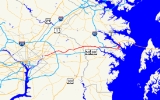
Maryland Route 450 is a state highway
in the U.S. state
of Maryland
. The state highway runs 30.19 mi (48.6 km) from U.S. Route 1 Alternate (US 1 Alternate) in Bladensburg
east to US 50
, US 301
, and MD 2
near Annapolis
. MD 450 is the original alignment of US 50 in Prince George's
and Anne Arundel
Counties. The state highway was assigned to sections of old US 50 in the 1950s as US 50 was gradually moved to the limited-access John Hanson Highway.
 MD 450 begins at an intersection with US 1 Alternate in Bladensburg. The state highway heads east as Annapolis Road through Bladensburg, passing through an interchange with MD 201
, a wye intersection with MD 202
, and an interchange with the Baltimore-Washington Parkway
. MD 450 heads into Landover Hills
, where the highway meets MD 410
and its interchange with the Capital Beltway
, then crosses the Amtrak Northeast Corridor immediately after a partial interchange with MD 564
. The state highway continues east through Lanham, where the road intersects MD 704
and MD 193
. After crossing CSX
's Popes Creek Subdivision
, MD 450 crosses MD 197
in Bowie
. The state highway joins MD 3
in a concurrency
on the east side of Bowie; the two highways cross the Patuxent River
together on the Priest Bridge into Anne Arundel County.
Shortly after the bridge, MD 450 separates from MD 3 and heads east as Defense Highway through Crofton
, where the highway intersects MD 424
. The state highway continues east through a hilly area where the highway passes under I-97
. MD 450 continues east into Annapolis, where the highway meets MD 178
adjacent to the Annapolis Mall
. After an interchange with US 50 and US 301
, the state highway continues into Annapolis as West Street. MD 450 meets MD 2
on the west side of the city then intersects MD 435
and MD 387
at Westgate Circle. The state highway passes through Church Circle, from which the highway continues as College Avenue. After intersecting the southern terminus of MD 70
, MD 450 turns north onto King George Street. The state highway follows the edge of the campus of the United States Naval Academy
northwest and then northeast after the junction with the other end of MD 435. MD 450 crosses the Severn River
on the Naval Academy Bridge
and meets MD 648
on the other side. The state highway, now following Governor Ritchie Highway, turns to the northwest before reaching its eastern terminus at an interchange with US 50, US 301, and MD 2.
State highway
State highway, state road or state route can refer to one of three related concepts, two of them related to a state or provincial government in a country that is divided into states or provinces :#A...
in the U.S. state
U.S. state
A U.S. state is any one of the 50 federated states of the United States of America that share sovereignty with the federal government. Because of this shared sovereignty, an American is a citizen both of the federal entity and of his or her state of domicile. Four states use the official title of...
of Maryland
Maryland
Maryland is a U.S. state located in the Mid Atlantic region of the United States, bordering Virginia, West Virginia, and the District of Columbia to its south and west; Pennsylvania to its north; and Delaware to its east...
. The state highway runs 30.19 mi (48.6 km) from U.S. Route 1 Alternate (US 1 Alternate) in Bladensburg
Bladensburg, Maryland
Bladensburg is a town in Prince George's County, Maryland, United States. The population was 7,661 at the 2000 census.Bladensburg is from central Washington, DC...
east to US 50
U.S. Route 50 in Maryland
U.S. Route 50 is a major east–west route of the U.S. Highway system, stretching just over from Ocean City, Maryland on the Atlantic Ocean to West Sacramento, California. In the U.S. state of Maryland, US 50 exists in two sections. The longer of these serves as a major route connecting...
, US 301
U.S. Route 301 in Maryland
U.S. Route 301 in Maryland is a major highway that runs from Delaware to the Governor Harry W. Nice Memorial Bridge into Virginia. It passes through three of Maryland's four main regions: the Eastern Shore, the Baltimore-Washington Metropolitan Area, and Southern Maryland...
, and MD 2
Maryland Route 2
Maryland Route 2 is the longest state highway in the U.S. state of Maryland. The route runs from Solomons Island in Calvert County north to an intersection with U.S. Route 1 and U.S. Route 40 Truck in Baltimore...
near Annapolis
Annapolis, Maryland
Annapolis is the capital of the U.S. state of Maryland, as well as the county seat of Anne Arundel County. It had a population of 38,394 at the 2010 census and is situated on the Chesapeake Bay at the mouth of the Severn River, south of Baltimore and about east of Washington, D.C. Annapolis is...
. MD 450 is the original alignment of US 50 in Prince George's
Prince George's County, Maryland
Prince George's County is a county located in the U.S. state of Maryland, immediately north, east, and south of Washington, DC. As of 2010, it has a population of 863,420 and is the wealthiest African-American majority county in the nation....
and Anne Arundel
Anne Arundel County, Maryland
Anne Arundel County is a county located in the U.S. state of Maryland. It is named for Anne Arundell , a member of the ancient family of Arundells in Cornwall, England and the wife of Cæcilius Calvert, 2nd Baron Baltimore. Its county seat is Annapolis, which is also the capital of the state...
Counties. The state highway was assigned to sections of old US 50 in the 1950s as US 50 was gradually moved to the limited-access John Hanson Highway.
Route description
Maryland Route 201
-Route description:MD 201 begins at a large hybrid cloverleaf just outside the D.C. boundary at Tuxedo, Maryland that is maintained by the Maryland State Highway Administration...
, a wye intersection with MD 202
Maryland Route 202
Maryland Route 202 is a north–south state highway in Prince George's County within the U.S. state of Maryland. MD 202 travels through many communities in central Prince George's County, and is known as Maryland Route 202 (MD 202) is a north–south state highway in Prince George's...
, and an interchange with the Baltimore-Washington Parkway
Baltimore-Washington Parkway
The Baltimore–Washington Parkway is a highway in the U.S. state of Maryland, running southwest from Baltimore to Washington, D.C. The road begins at an interchange with U.S. Route 50 and Maryland Route 201 near Cheverly in Prince George's County at the D.C...
. MD 450 heads into Landover Hills
Landover Hills, Maryland
Landover Hills is a town in Prince George's County, Maryland, United States. The population was 1,534 at the 2000 census.It has a neighborhood named Defense Heights.-Bordering areas:* Woodlawn * Greater Landover...
, where the highway meets MD 410
Maryland Route 410
Maryland Route 410 is a state highway in the U.S. state of Maryland. Known for most of its length as East–West Highway, the highway runs from MD 355 in Bethesda east to Pennsy Drive in Landover Hills...
and its interchange with the Capital Beltway
Interstate 495 (Capital Beltway)
Interstate 495 is a Interstate Highway that surrounds the United States' capital of Washington, D.C., and its inner suburbs in adjacent Maryland and Virginia. I-495 is widely known as the Capital Beltway or simply the Beltway, especially when the context of Washington, D.C., is clear...
, then crosses the Amtrak Northeast Corridor immediately after a partial interchange with MD 564
Maryland Route 564
Maryland Route 564 is a state highway in the U.S. state of Maryland. Known for most of its length as Lanham Severn Road, the state highway runs from MD 450 in Lanham east to a dead end near a connection to MD 197 in Bowie.-Route description:...
. The state highway continues east through Lanham, where the road intersects MD 704
Maryland Route 704
Maryland Route 704 is a state highway in the U.S. state of Maryland. Known as Martin Luther King Jr. Highway, the state highway runs from Eastern Avenue at the District of Columbia boundary in Seat Pleasant east to MD 450 in Lanham....
and MD 193
Maryland Route 193
Maryland Route 193 is a state highway in the U.S. state of Maryland. Known for most of its length as University Boulevard and Greenbelt Road, the state highway runs from MD 185 in Kensington east to MD 202 in Greater Upper Marlboro...
. After crossing CSX
CSX Transportation
CSX Transportation operates a Class I railroad in the United States known as the CSX Railroad. It is the main subsidiary of the CSX Corporation. The company is headquartered in Jacksonville, Florida, and owns approximately 21,000 route miles...
's Popes Creek Subdivision
Popes Creek Subdivision
The Pope's Creek Subdivision is a CSX Transportation railroad line in Maryland, running from Bowie to Morgantown and the Chalk Point Generating Station.- History :...
, MD 450 crosses MD 197
Maryland Route 197
Maryland Route 197 is a state highway in the U.S. state of Maryland. Known for most of its length as Laurel–Bowie Road, the state highway runs from U.S. Route 301 in Bowie north to MD 198 in Laurel. In addition to being the main connection between Bowie and Laurel, MD 197 provides access...
in Bowie
Bowie, Maryland
Bowie is a city in Prince George's County, Maryland, United States. The population was 54,727 at the 2010 census. Bowie has grown from a small railroad stop to the largest municipality in Prince George's County, and the fifth most populous city and third largest city by area in the state of...
. The state highway joins MD 3
Maryland Route 3
Maryland Route 3, also part of Robert Crain Highway, is the designation given to the former alignment of U.S. Route 301 from Bowie, Maryland, USA, to Baltimore. It is named for Robert Crain of Baltimore.-Route description:...
in a concurrency
Concurrency (road)
A concurrency, overlap, or coincidence in a road network is an instance of one physical road bearing two or more different highway, motorway, or other route numbers...
on the east side of Bowie; the two highways cross the Patuxent River
Patuxent River
The Patuxent River is a tributary of the Chesapeake Bay in the state of Maryland. There are three main river drainages for central Maryland: the Potomac River to the west passing through Washington D.C., the Patapsco River to the northeast passing through Baltimore, and the Patuxent River between...
together on the Priest Bridge into Anne Arundel County.
Shortly after the bridge, MD 450 separates from MD 3 and heads east as Defense Highway through Crofton
Crofton, Maryland
Crofton is a census-designated place and planned community in Anne Arundel County, Maryland, United States. Established in 1964, Crofton held its 40th birthday celebration in 2004....
, where the highway intersects MD 424
Maryland Route 424
Maryland Route 424 is a state highway in the U.S. state of Maryland. Known as Davidsonville Road, the state highway runs from MD 214 in Davidsonville north to MD 3 in Crofton.-Route description:...
. The state highway continues east through a hilly area where the highway passes under I-97
Interstate 97
Interstate 97 is an intrastate Interstate Highway located entirely within Anne Arundel County, Maryland, United States. It runs from Annapolis at the overlapped section of US 50, US 301, and the unsigned I-595 to Baltimore at the city's beltway...
. MD 450 continues east into Annapolis, where the highway meets MD 178
Maryland Route 178
Maryland Route 178, known locally as Generals Highway, is a north–south highway in Anne Arundel County, Maryland. It parallels Interstate 97 and once was the main eastbound route to Annapolis, Maryland. It begins at its intersection with Maryland Route 450 in Parole, near the Westfield...
adjacent to the Annapolis Mall
Annapolis Mall
Annapolis Mall, officially known as Westfield Annapolis, is a shopping mall owned by the Westfield Group that is located near the junction of U.S. Route 50 and Interstate 97 in Annapolis, Maryland...
. After an interchange with US 50 and US 301
U.S. Route 301 in Maryland
U.S. Route 301 in Maryland is a major highway that runs from Delaware to the Governor Harry W. Nice Memorial Bridge into Virginia. It passes through three of Maryland's four main regions: the Eastern Shore, the Baltimore-Washington Metropolitan Area, and Southern Maryland...
, the state highway continues into Annapolis as West Street. MD 450 meets MD 2
Maryland Route 2
Maryland Route 2 is the longest state highway in the U.S. state of Maryland. The route runs from Solomons Island in Calvert County north to an intersection with U.S. Route 1 and U.S. Route 40 Truck in Baltimore...
on the west side of the city then intersects MD 435
Maryland Route 435
Maryland Route 435 is a state highway in the U.S. state of Maryland. The route runs between two different intersections with Maryland Route 450, one in western Annapolis and the other in northwestern Annapolis. As a result, MD 435 serves as a bypass of Downtown Annapolis...
and MD 387
Maryland Route 387
Maryland Route 387 is a state highway in the U.S. state of Maryland. Known as Spa Road, the route runs from the beginning of state maintenance near Ferry Point Road north to Maryland Route 450 within Annapolis.-Route description:...
at Westgate Circle. The state highway passes through Church Circle, from which the highway continues as College Avenue. After intersecting the southern terminus of MD 70
Maryland Route 70
Maryland Route 70 is a state highway in Annapolis, Maryland.-Route description:Maryland Route 70 begins at an intersection with Maryland Route 450 in downtown Annapolis, following the dual Bladen Street at its southern beginning. After a few blocks, Rowe Boulevard merges into Bladen Street, and...
, MD 450 turns north onto King George Street. The state highway follows the edge of the campus of the United States Naval Academy
United States Naval Academy
The United States Naval Academy is a four-year coeducational federal service academy located in Annapolis, Maryland, United States...
northwest and then northeast after the junction with the other end of MD 435. MD 450 crosses the Severn River
Severn River (Maryland)
The Severn River runs through Anne Arundel County in the U.S. state of Maryland. It is located south of the Magothy River, and north of the South River.-Geography:...
on the Naval Academy Bridge
Naval Academy Bridge
The U.S. Naval Academy Bridge is a bridge that crosses the Severn River in Annapolis, Maryland. It is located downriver from the Severn River Bridge and adjacent to the United States Naval Academy...
and meets MD 648
Maryland Route 648
Maryland Route 648 is a collection of state highways in the U.S. state of Maryland. These highways are sections of Baltimore–Annapolis Boulevard, the old alignment of MD 2 between Annapolis and Glen Burnie. These segments were bypassed when MD 2 was moved to Governor Ritchie Highway, a...
on the other side. The state highway, now following Governor Ritchie Highway, turns to the northwest before reaching its eastern terminus at an interchange with US 50, US 301, and MD 2.
History
MD 450 is the old alignment of US 50 between Bladensburg and Annapolis. The portion east of downtown Annapolis was also once part of MD 2. MD 450 was assigned to the highway it follows as sections of John Hanson Highway were completed in the 1950s.Junction list
| County | Location | Mile |
Destinations | Notes |
|---|---|---|---|---|
| Prince George's Prince George's County, Maryland Prince George's County is a county located in the U.S. state of Maryland, immediately north, east, and south of Washington, DC. As of 2010, it has a population of 863,420 and is the wealthiest African-American majority county in the nation.... 14.36 mi (23.1 km) |
Bladensburg Bladensburg, Maryland Bladensburg is a town in Prince George's County, Maryland, United States. The population was 7,661 at the 2000 census.Bladensburg is from central Washington, DC... |
0.00 | , Washington Washington, D.C. Washington, D.C., formally the District of Columbia and commonly referred to as Washington, "the District", or simply D.C., is the capital of the United States. On July 16, 1790, the United States Congress approved the creation of a permanent national capital as permitted by the U.S. Constitution.... |
Western terminus of MD 450 |
| 0.21 | , Washington Washington, D.C. Washington, D.C., formally the District of Columbia and commonly referred to as Washington, "the District", or simply D.C., is the capital of the United States. On July 16, 1790, the United States Congress approved the creation of a permanent national capital as permitted by the U.S. Constitution.... |
|||
| 0.33 | 48th Street to | 48th Street south is unsigned MD 769C and old alignment of MD 201 | ||
| 0.42 | Edmonston Road north – Edmonston Edmonston, Maryland Edmonston is a town in Prince George's County, Maryland, in the United States. As of the 2000 census, the town population was 959.It is from Washington, D.C. Edmonston's ZIP code is 20781.-History:... |
Unsigned MD 769B; former MD 205 | ||
| 0.93 | No direct access between MD 450 east and MD 202 east | |||
| 1.52 | , Washington Washington, D.C. Washington, D.C., formally the District of Columbia and commonly referred to as Washington, "the District", or simply D.C., is the capital of the United States. On July 16, 1790, the United States Congress approved the creation of a permanent national capital as permitted by the U.S. Constitution.... |
|||
| Landover Hills Landover Hills, Maryland Landover Hills is a town in Prince George's County, Maryland, United States. The population was 1,534 at the 2000 census.It has a neighborhood named Defense Heights.-Bordering areas:* Woodlawn * Greater Landover... |
3.44 | |||
| Lanham Lanham, Maryland Lanham is an unincorporated community in Prince George's County in the State of Maryland in the United States of America. Because it is not formally incorporated, it has no official boundaries, but the United States Census Bureau has defined a census-designated place consisting of Lanham and the... |
4.65 | , Richmond Richmond, Virginia Richmond is the capital of the Commonwealth of Virginia, in the United States. It is an independent city and not part of any county. Richmond is the center of the Richmond Metropolitan Statistical Area and the Greater Richmond area... |
||
| 4.95 | Eastbound exit and westbound entrance | |||
| 7.32 | ||||
| 7.87 | Old alignment of MD 193 | |||
| 8.79 | ||||
| Bowie Bowie, Maryland Bowie is a city in Prince George's County, Maryland, United States. The population was 54,727 at the 2010 census. Bowie has grown from a small railroad stop to the largest municipality in Prince George's County, and the fifth most populous city and third largest city by area in the state of... |
11.38 | |||
| 14.10 | , Richmond Richmond, Virginia Richmond is the capital of the Commonwealth of Virginia, in the United States. It is an independent city and not part of any county. Richmond is the center of the Richmond Metropolitan Statistical Area and the Greater Richmond area... |
West end of concurrency with MD 3 | ||
| Priest Bridge – Patuxent River Patuxent River The Patuxent River is a tributary of the Chesapeake Bay in the state of Maryland. There are three main river drainages for central Maryland: the Potomac River to the west passing through Washington D.C., the Patapsco River to the northeast passing through Baltimore, and the Patuxent River between... |
||||
| Anne Arundel Anne Arundel County, Maryland Anne Arundel County is a county located in the U.S. state of Maryland. It is named for Anne Arundell , a member of the ancient family of Arundells in Cornwall, England and the wife of Cæcilius Calvert, 2nd Baron Baltimore. Its county seat is Annapolis, which is also the capital of the state... 15.83 mi (25.5 km) |
Crofton Crofton, Maryland Crofton is a census-designated place and planned community in Anne Arundel County, Maryland, United States. Established in 1964, Crofton held its 40th birthday celebration in 2004.... |
East end of concurrency with MD 3 | ||
| Annapolis Annapolis, Maryland Annapolis is the capital of the U.S. state of Maryland, as well as the county seat of Anne Arundel County. It had a population of 38,394 at the 2010 census and is situated on the Chesapeake Bay at the mouth of the Severn River, south of Baltimore and about east of Washington, D.C. Annapolis is... |
MD 450 turns south at this intersection | |||
| 0 | / Jennifer Road east – Washington Washington, D.C. Washington, D.C., formally the District of Columbia and commonly referred to as Washington, "the District", or simply D.C., is the capital of the United States. On July 16, 1790, the United States Congress approved the creation of a permanent national capital as permitted by the U.S. Constitution.... , Richmond Richmond, Virginia Richmond is the capital of the Commonwealth of Virginia, in the United States. It is an independent city and not part of any county. Richmond is the center of the Richmond Metropolitan Statistical Area and the Greater Richmond area... , Baltimore |
|||
| / Riva Road south – Bay Bridge Chesapeake Bay Bridge The Chesapeake Bay Bridge is a major dual-span bridge in the U.S. state of Maryland. Spanning the Chesapeake Bay, it connects the state's rural Eastern Shore region with the more urban Western Shore. The original span opened in 1952 and, at the time, with a length of , it was the world's longest... |
||||
| 0 | Old alignment of MD 2 | |||
| 0 | Westgate Circle roundabout | |||
| Duke of Gloucester Street east / School Street north – Maryland State House Maryland State House The Maryland State House is located in Annapolis and is the oldest state capitol in continuous legislative use, dating to 1772. It houses the Maryland General Assembly and offices of the Governor and Lieutenant Governor. The capitol has the distinction of being topped by the largest wooden dome in... |
Church Circle traffic circle; MD 450 continues east onto College Avenue | |||
| King George Street east | MD 450 turns west onto King George Street | |||
| MD 450 turns north at this intersection | ||||
| Naval Academy Bridge Naval Academy Bridge The U.S. Naval Academy Bridge is a bridge that crosses the Severn River in Annapolis, Maryland. It is located downriver from the Severn River Bridge and adjacent to the United States Naval Academy... – Severn River Severn River (Maryland) The Severn River runs through Anne Arundel County in the U.S. state of Maryland. It is located south of the Magothy River, and north of the South River.-Geography:... |
||||
| , Washington Washington, D.C. Washington, D.C., formally the District of Columbia and commonly referred to as Washington, "the District", or simply D.C., is the capital of the United States. On July 16, 1790, the United States Congress approved the creation of a permanent national capital as permitted by the U.S. Constitution.... |
Eastern terminus of MD 450 | |||