
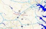
Maryland Route 198
Encyclopedia
Maryland Route 198 is an east–west state highway
in the central part of the U.S. state
of Maryland
that connects Fort Meade at Maryland Route 32
to Maryland Route 28
and Maryland Route 650
(New Hampshire Avenue) near Spencerville.
New Hampshire Avenue and Norbeck Road (an at-grade extension of MD 28
from its eastern terminus at MD 182
), several miles to the south of Ashton
. Originally, Norbeck Road did not exist at this intersection, and MD 198 ended at a small three-way intersection with MD 650 several hundred yards to the north.
East of here, MD 198 is a busy 40 mi/h suburban/rural arterial known as Spencerville Road, carrying traffic through central Montgomery County
. Three miles to the east, in downtown Burtonsville
, it encounters Old Columbia Pike, the original alignment of US 29
, and also formerly signed as MD 196. At this intersection, MD 198 assumes the name of Old Columbia Pike. A short distance further east, the route encounters a second alignment of US 29, known as Columbia Pike, that was built in the late 1960s to carry the U.S. route around the Burtonsville Crossing Shopping Center. After the completion of roadworks on December 7, 2005, this alignment of US 29 is out of use as a through mainline route and now serves merely as a local arterial for the community; the segment north of MD 198 ends at Dustin Road, while the segment south was removed. Slightly further to the east, MD 198 encounters the current alignment of US 29 through Burtonsville. This alignment is much straighter than the previous alignment and links with MD 198 via a grade-separated 3/4 diamond interchange.
. The two routes interchange via a large, high-speed partially unrolled cloverleaf, with the connection between MD 198 west and I-95 south being served via a semidirectional ramp. In the northeast quadrant of the interchange, Old Sandy Spring Road (a former alignment of MD 198) begins at a dead end and parallels the current routing eastward.
Beyond I-95, MD 198 maintains its four-lane non-limited access cross-section as it passes a major branch office of Tower Federal Credit Union as it enters Laurel
.
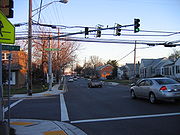 At 9th St. in downtown Laurel, MD 198 splits into a one-way couplet; the eastbound component is known as Gorman Avenue, and the westbound component is known as Talbott Avenue. Heading east, the couplet crosses the southern terminus of MD 216
(7th St.) and US 1
, itself a couplet.
Camden Line) and Lafayette Road. Beyond the crossing, MD 198 is known as Fort Meade Road, and meets the northern terminus of MD 197
several hundred yards east of the B&O. Past MD 197, MD 198 resumes its four-lane non-limited access cross section and again serves as a major arterial, carrying heavy suburban and commuter traffic between Laurel and points east. Near the route's crossing of the Patuxent River
, the route connects with Laurel Race Track Road, which serves the Laurel Park Racecourse. Continuing east, the route crosses several suburban and rural roads before meeting the Baltimore-Washington Parkway
at a modified cloverleaf interchange.
and crossing the Little Patuxent River
near a water treatment plant before veering away from its original alignment to run parallel to MD 32
for a short distance. Eventually, MD 198 reaches a dumbbell interchange with MD 32. Beyond this interchange, MD 198 becomes unsigned and winds its way to the entrance to Fort Meade
, where it terminates; the roadway continues into the fort as Mapes Rd., eventually reaching MD 175
.
was severed by the Baltimore-Washington Parkway
in the 1950s, MD 198 was extended east of Laurel to replace it. Before the construction of the Patuxent Freeway (Maryland Route 32
) was begun between the MD 32/I-95 interchange and MD 32/B-W Parkway interchange, MD 198 was a far better route for commuters traveling from the west and south who wished to access Fort Meade, as MD 32's routing at the time (Guilford Road) was a small, two-lane country road with very low traffic-carrying capacity. The design of the I-95/MD 198 interchange, with the semidirectional connection from MD 198 west to I-95 south, further alludes to MD 198's former importance as the primary access point from points west to Fort Meade.
In 1989, a new overpass to carry Route 198 over the Baltimore-Washington Parkway
just east of Laurel collapsed during rush hour, injuring 14 motorists and construction workers. The incident was blamed on faulty scaffolding used to support the uncompleted span.
State highway
State highway, state road or state route can refer to one of three related concepts, two of them related to a state or provincial government in a country that is divided into states or provinces :#A...
in the central part of the U.S. state
U.S. state
A U.S. state is any one of the 50 federated states of the United States of America that share sovereignty with the federal government. Because of this shared sovereignty, an American is a citizen both of the federal entity and of his or her state of domicile. Four states use the official title of...
of Maryland
Maryland
Maryland is a U.S. state located in the Mid Atlantic region of the United States, bordering Virginia, West Virginia, and the District of Columbia to its south and west; Pennsylvania to its north; and Delaware to its east...
that connects Fort Meade at Maryland Route 32
Maryland Route 32
Maryland Route 32 is a state highway in the U.S. state of Maryland. The state highway runs from Interstate 97 and MD 3 in Millersville west and north to Washington Road in Westminster. The east–west portion of MD 32 is the Patuxent Freeway, a four- to six-lane...
to Maryland Route 28
Maryland Route 28
Maryland Route 28 is a state highway in the U.S. state of Maryland. The state highway runs from U.S. Route 15 in Point of Rocks east to MD 182 in Norwood. The western portion of MD 28 is a rural highway connecting several villages in southern Frederick County and western Montgomery County...
and Maryland Route 650
Maryland Route 650
Maryland Route 650 is a state highway in the U.S. state of Maryland. Known as New Hampshire Avenue for most of its length, the state highway runs from Eastern Avenue at the Washington, D.C. border north to MD 108 in Etchison...
(New Hampshire Avenue) near Spencerville.
Spencerville Road
MD 198 begins at a four-way intersection between MD 650Maryland Route 650
Maryland Route 650 is a state highway in the U.S. state of Maryland. Known as New Hampshire Avenue for most of its length, the state highway runs from Eastern Avenue at the Washington, D.C. border north to MD 108 in Etchison...
New Hampshire Avenue and Norbeck Road (an at-grade extension of MD 28
Maryland Route 28
Maryland Route 28 is a state highway in the U.S. state of Maryland. The state highway runs from U.S. Route 15 in Point of Rocks east to MD 182 in Norwood. The western portion of MD 28 is a rural highway connecting several villages in southern Frederick County and western Montgomery County...
from its eastern terminus at MD 182
Maryland Route 182
Maryland Route 182 is a road that runs between Olney and Glenmont, Maryland. The road is first known as Dr. Bird Road for a short distance before becoming Norwood Road. When the road reaches Norwood, a right turn is required to stay on the route, which for its remainder is known as Layhill Road...
), several miles to the south of Ashton
Ashton, Maryland
Ashton is an unincorporated area in Montgomery County, Maryland. The commercial center of Ashton lies at the junction of Route 108 and New Hampshire Avenue ....
. Originally, Norbeck Road did not exist at this intersection, and MD 198 ended at a small three-way intersection with MD 650 several hundred yards to the north.
East of here, MD 198 is a busy 40 mi/h suburban/rural arterial known as Spencerville Road, carrying traffic through central Montgomery County
Montgomery County, Maryland
Montgomery County is a county in the U.S. state of Maryland, situated just to the north of Washington, D.C., and southwest of the city of Baltimore. It is one of the most affluent counties in the United States, and has the highest percentage of residents over 25 years of age who hold post-graduate...
. Three miles to the east, in downtown Burtonsville
Burtonsville, Maryland
Burtonsville is a census-designated place and an unincorporated area in Montgomery County, Maryland, United States.-History:In colonial times, the area was referred to as the Patuxent Hundred and later the Eastern Branch Hundred, a community comprising about 100 inhabitants...
, it encounters Old Columbia Pike, the original alignment of US 29
U.S. Route 29 in Maryland
U.S. Route 29 is a north–south United States highway that runs for from the western suburbs of Baltimore, Maryland, to Pensacola, Florida. In the U.S. state of Maryland, US 29 is a major highway that emerges from Washington D.C. and runs north into eastern Montgomery County, stretching...
, and also formerly signed as MD 196. At this intersection, MD 198 assumes the name of Old Columbia Pike. A short distance further east, the route encounters a second alignment of US 29, known as Columbia Pike, that was built in the late 1960s to carry the U.S. route around the Burtonsville Crossing Shopping Center. After the completion of roadworks on December 7, 2005, this alignment of US 29 is out of use as a through mainline route and now serves merely as a local arterial for the community; the segment north of MD 198 ends at Dustin Road, while the segment south was removed. Slightly further to the east, MD 198 encounters the current alignment of US 29 through Burtonsville. This alignment is much straighter than the previous alignment and links with MD 198 via a grade-separated 3/4 diamond interchange.
Sandy Spring Road
Beyond the route's interchange with US 29, MD 198 widens into a four-lane non-limited access arterial and carries moderate to heavy amounts of traffic on an east–west alignment. Here, it is known as Sandy Spring Road, and passes to the north of a major industrial complex and electrical substation before meeting I-95Interstate 95 in Maryland
Interstate 95 in Maryland is a major highway that runs diagonally from northeast to southwest, from Maryland's border with Delaware, to the Woodrow Wilson Bridge, briefly entering the District of Columbia before reaching Virginia...
. The two routes interchange via a large, high-speed partially unrolled cloverleaf, with the connection between MD 198 west and I-95 south being served via a semidirectional ramp. In the northeast quadrant of the interchange, Old Sandy Spring Road (a former alignment of MD 198) begins at a dead end and parallels the current routing eastward.
Beyond I-95, MD 198 maintains its four-lane non-limited access cross-section as it passes a major branch office of Tower Federal Credit Union as it enters Laurel
Laurel, Maryland
Laurel is a city in northern Prince George's County, Anne Arundel County, and Howard County, Maryland, United States, located midway between Washington, D.C. and Baltimore. Incorporated in 1870, the city maintains a historic district including its Main Street...
.
Gorman Avenue/Talbott Avenue
Maryland Route 216
Maryland Route 216 is a Maryland between Laurel and Highland, primarily within Howard County. The name for Route 216 is Scaggsville Road.-7th Street, Laurel:...
(7th St.) and US 1
U.S. Route 1 in Maryland
U.S. Route 1 is the easternmost and longest of the major north–south routes of the United States Numbered Highway System, running from Key West, Florida to Fort Kent, Maine. In the U.S...
, itself a couplet.
Fort Meade Road
At US 1, the couplet collapses into a normal four-lane non-limited access carriageway as it crosses the B&O Capital Subdivision (also known as the MARCMARC Train
MARC , known prior to 1984 as Maryland Rail Commuter Service, is a regional rail system comprising three lines in the Baltimore-Washington Metropolitan Area. MARC is administered by the Maryland Transit Administration , a Maryland Department of Transportation agency, and is operated under contract...
Camden Line) and Lafayette Road. Beyond the crossing, MD 198 is known as Fort Meade Road, and meets the northern terminus of MD 197
Maryland Route 197
Maryland Route 197 is a state highway in the U.S. state of Maryland. Known for most of its length as Laurel–Bowie Road, the state highway runs from U.S. Route 301 in Bowie north to MD 198 in Laurel. In addition to being the main connection between Bowie and Laurel, MD 197 provides access...
several hundred yards east of the B&O. Past MD 197, MD 198 resumes its four-lane non-limited access cross section and again serves as a major arterial, carrying heavy suburban and commuter traffic between Laurel and points east. Near the route's crossing of the Patuxent River
Patuxent River
The Patuxent River is a tributary of the Chesapeake Bay in the state of Maryland. There are three main river drainages for central Maryland: the Potomac River to the west passing through Washington D.C., the Patapsco River to the northeast passing through Baltimore, and the Patuxent River between...
, the route connects with Laurel Race Track Road, which serves the Laurel Park Racecourse. Continuing east, the route crosses several suburban and rural roads before meeting the Baltimore-Washington Parkway
Baltimore-Washington Parkway
The Baltimore–Washington Parkway is a highway in the U.S. state of Maryland, running southwest from Baltimore to Washington, D.C. The road begins at an interchange with U.S. Route 50 and Maryland Route 201 near Cheverly in Prince George's County at the D.C...
at a modified cloverleaf interchange.
Laurel-Fort Meade Road
Beyond the B-W Parkway, MD 198 narrows to a fast two-lane highway known locally as Laurel-Fort Meade Road and continues due east, passing an old alignment of MD 216Maryland Route 216
Maryland Route 216 is a Maryland between Laurel and Highland, primarily within Howard County. The name for Route 216 is Scaggsville Road.-7th Street, Laurel:...
and crossing the Little Patuxent River
Patuxent River
The Patuxent River is a tributary of the Chesapeake Bay in the state of Maryland. There are three main river drainages for central Maryland: the Potomac River to the west passing through Washington D.C., the Patapsco River to the northeast passing through Baltimore, and the Patuxent River between...
near a water treatment plant before veering away from its original alignment to run parallel to MD 32
Maryland Route 32
Maryland Route 32 is a state highway in the U.S. state of Maryland. The state highway runs from Interstate 97 and MD 3 in Millersville west and north to Washington Road in Westminster. The east–west portion of MD 32 is the Patuxent Freeway, a four- to six-lane...
for a short distance. Eventually, MD 198 reaches a dumbbell interchange with MD 32. Beyond this interchange, MD 198 becomes unsigned and winds its way to the entrance to Fort Meade
Fort Meade, Maryland
Fort Meade is a census-designated place in Anne Arundel County, Maryland, United States. The population was 9,882 at the 2000 census. It is the home to the National Security Agency, which is located on the US Army post Fort George G...
, where it terminates; the roadway continues into the fort as Mapes Rd., eventually reaching MD 175
Maryland Route 175
-Annapolis Road:MD 175 begins at MD 3, just south of the latter's northern terminus at Interstate 97, known as Annapolis Road. It runs west as a two-lane suburban highway, passing through local neighborhoods and south of Arundel High School before widening into a four-lane suburban arterial south...
.
Junction list
| County | Location | Mile | Destinations | Notes |
|---|---|---|---|---|
| Montgomery Montgomery County, Maryland Montgomery County is a county in the U.S. state of Maryland, situated just to the north of Washington, D.C., and southwest of the city of Baltimore. It is one of the most affluent counties in the United States, and has the highest percentage of residents over 25 years of age who hold post-graduate... |
Spencerville Spencerville, Maryland Spencerville is an unincorporated community in Montgomery County, Maryland, United States. Spencerville is north of Cloverly. Spencerville has a post office with ZIP code 20868.... |
0.0 | Western terminus Continues west as Norbeck Road to MD 28 |
|
| 0.73 | Good Hope Road south – Spencerville Park | |||
| 1.51 | Peach Orchard Road south | |||
| 1.97 | Oursler Road north – Burtonsville Park | |||
| 2.31 | Kruhm Road – Union Cemetery (Burtonsville) | |||
| Burtonsville Burtonsville, Maryland Burtonsville is a census-designated place and an unincorporated area in Montgomery County, Maryland, United States.-History:In colonial times, the area was referred to as the Patuxent Hundred and later the Eastern Branch Hundred, a community comprising about 100 inhabitants... |
3.11 | Old Columbia Pike south – White Oak White Oak, Maryland White Oak is a census-designated place and an unincorporated area in Montgomery County, Maryland, United States.-Geography:As an unincorporated area, White Oak's boundaries are not officially defined... (to US 29 U.S. Route 29 in Maryland U.S. Route 29 is a north–south United States highway that runs for from the western suburbs of Baltimore, Maryland, to Pensacola, Florida. In the U.S. state of Maryland, US 29 is a major highway that emerges from Washington D.C. and runs north into eastern Montgomery County, stretching... ) |
Former alignment of both MD 196 and US 29 | |
| 3.45 | – Burtonsville Crossing Shopping Center | Former US 29 between 1966 and 2005; route is unsigned US 29A | ||
| 3.61 | Interchange | |||
| 4.21 | Cedar Tree Drive south | |||
| 4.75 | Riding Stable Road north – to Brooklyn Bridge Road | |||
| Prince George's Prince George's County, Maryland Prince George's County is a county located in the U.S. state of Maryland, immediately north, east, and south of Washington, DC. As of 2010, it has a population of 863,420 and is the wealthiest African-American majority county in the nation.... |
5.13 | Old Gunpowder Road /Bond Mill Road | ||
| 5.56 | Sweitzer Lane | road serves a major industrial complex | ||
| 6.09 | , Washington | Interchange | ||
| Laurel Laurel, Maryland Laurel is a city in northern Prince George's County, Anne Arundel County, and Howard County, Maryland, United States, located midway between Washington, D.C. and Baltimore. Incorporated in 1870, the city maintains a historic district including its Main Street... |
7.09 | Van Dusen Road – Laurel Regional Hospital, Tower Federal Credit Union (to Old Sandy Spring Rd.) | ||
| 7.7 | 9th Street | road leads to former MD 216 crossing of Patuxent River Patuxent River The Patuxent River is a tributary of the Chesapeake Bay in the state of Maryland. There are three main river drainages for central Maryland: the Potomac River to the west passing through Washington D.C., the Patapsco River to the northeast passing through Baltimore, and the Patuxent River between... |
||
 splits into two one-way streets: Talbot Avenue westbound and Gorman Avenue eastbound splits into two one-way streets: Talbot Avenue westbound and Gorman Avenue eastbound |
||||
| 7.94 | MD 216 is maintained by the city of Laurel | |||
| 8.35 | Southbound one-way couplet of US 1 | |||
| 8.42 | Northbound one-way couplet of US 1 | |||
| merges into one two-way roadway and crosses the B&O Baltimore and Ohio Railroad The Baltimore and Ohio Railroad was one of the oldest railroads in the United States and the first common carrier railroad. It came into being mostly because the city of Baltimore wanted to compete with the newly constructed Erie Canal and another canal being proposed by Pennsylvania, which... Capital Subdivision |
||||
| 8.82 | MD 197 runs south of MD 198 | |||
| Anne Arundel Anne Arundel County, Maryland Anne Arundel County is a county located in the U.S. state of Maryland. It is named for Anne Arundell , a member of the ancient family of Arundells in Cornwall, England and the wife of Cæcilius Calvert, 2nd Baron Baltimore. Its county seat is Annapolis, which is also the capital of the state... |
9.35 | Laurel Race Track Road – Laurel Race Track | ||
| Maryland City Maryland City, Maryland Maryland City is a census-designated place in Anne Arundel County, Maryland, United States, a suburb of Washington, DC. The population was 6,814 at the 2000 census. It is located east of Laurel, just over the border with Prince George's County, and it has a Laurel zip code... |
9.76 | |||
| 10.32 | Old Annapolis Road / Whiskey Bottom Road Whiskey Bottom Road Whiskey Bottom Road is a historic road north of Laurel, Maryland that traverses Anne Arundel and Howard Counties.-Route description:Whiskey Bottom Road runs through North Laurel, Maryland starting at Maryland Route 198 in Anne Arundel County, Maryland. The road continues westward across U.S... – Bacontown Recreation Area, Maryland City Park |
|||
| 10.65 | Red Clay Road / Russett Green W. | |||
| 10.89 | Russett Green E. | |||
| 11.13 |   Baltimore-Washington Parkway The Baltimore–Washington Parkway is a highway in the U.S. state of Maryland, running southwest from Baltimore to Washington, D.C. The road begins at an interchange with U.S. Route 50 and Maryland Route 201 near Cheverly in Prince George's County at the D.C... – Baltimore, Washington Washington, D.C. Washington, D.C., formally the District of Columbia and commonly referred to as Washington, "the District", or simply D.C., is the capital of the United States. On July 16, 1790, the United States Congress approved the creation of a permanent national capital as permitted by the U.S. Constitution.... |
Interchange | ||
| 12.11 | Old Portland Road | Former alignment of MD 216 Alignment is unsigned MD 216B and 216I respectively |
||
| 12.25 | Welchs Court | |||
| 12.83 | Bald Eagle Drive south – Patuxent Wildlife Research Refuge | |||
| 13.15 | Old GV 198 | former alignment of MD 198 | ||
| 13.56 | Airfield Road – Tipton Airfield | |||
| 13.79 | Interchange | |||
| Fort Meade Fort Meade, Maryland Fort Meade is a census-designated place in Anne Arundel County, Maryland, United States. The population was 9,882 at the 2000 census. It is the home to the National Security Agency, which is located on the US Army post Fort George G... |
14.14 | Fort Meade Entrance | Eastern terminus Road continues into fort as Mapes Road |
|
History
After MD 216Maryland Route 216
Maryland Route 216 is a Maryland between Laurel and Highland, primarily within Howard County. The name for Route 216 is Scaggsville Road.-7th Street, Laurel:...
was severed by the Baltimore-Washington Parkway
Baltimore-Washington Parkway
The Baltimore–Washington Parkway is a highway in the U.S. state of Maryland, running southwest from Baltimore to Washington, D.C. The road begins at an interchange with U.S. Route 50 and Maryland Route 201 near Cheverly in Prince George's County at the D.C...
in the 1950s, MD 198 was extended east of Laurel to replace it. Before the construction of the Patuxent Freeway (Maryland Route 32
Maryland Route 32
Maryland Route 32 is a state highway in the U.S. state of Maryland. The state highway runs from Interstate 97 and MD 3 in Millersville west and north to Washington Road in Westminster. The east–west portion of MD 32 is the Patuxent Freeway, a four- to six-lane...
) was begun between the MD 32/I-95 interchange and MD 32/B-W Parkway interchange, MD 198 was a far better route for commuters traveling from the west and south who wished to access Fort Meade, as MD 32's routing at the time (Guilford Road) was a small, two-lane country road with very low traffic-carrying capacity. The design of the I-95/MD 198 interchange, with the semidirectional connection from MD 198 west to I-95 south, further alludes to MD 198's former importance as the primary access point from points west to Fort Meade.
In 1989, a new overpass to carry Route 198 over the Baltimore-Washington Parkway
Baltimore-Washington Parkway
The Baltimore–Washington Parkway is a highway in the U.S. state of Maryland, running southwest from Baltimore to Washington, D.C. The road begins at an interchange with U.S. Route 50 and Maryland Route 201 near Cheverly in Prince George's County at the D.C...
just east of Laurel collapsed during rush hour, injuring 14 motorists and construction workers. The incident was blamed on faulty scaffolding used to support the uncompleted span.