
Maryland Route 272
Encyclopedia
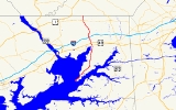
Maryland Route 272 is a state highway
in the U.S. state
of Maryland
. The state highway runs 20.67 miles (33.3 km) from Turkey Point within Elk Neck State Park
north through North East
to the Pennsylvania
state line near Calvert
, where the highway continues as Pennsylvania Route 272
(PA 272). MD 272 is the main north–south highway of central Cecil County
, connecting the Elk Neck between the North East River
and Elk River
with U.S. Route 40
(US 40) in North East, Interstate 95
(I-95) in Bay View, MD 273
in Calvert, and Rising Sun
via MD 274
. The state highway contains a section of MD 274 Truck between MD 274 in Bay View and MD 273 in Calvert.
The section of MD 272 between North East and Bay View was paved by 1910. The remainder of the state highway north to Calvert and south to Old Elk Neck Road was completed in several sections in the 1930s. The first relocations of MD 272 occurred when both railroads near North East were bridged in the early 1940s and early 1950s. Multiple relocations occurred in the late 1950s and early 1960s along the whole length of the highway to eliminate curves and tie the state highway into I-95. MD 272 reached its current extent when it was extended south into Elk Neck State Park around 1980.
within Elk Neck State Park. The state highway heads north as two-lane Turkey Point Road through a residential area before returning to the state park property. MD 272 passes through several curves and passes by access roads to the Elk River and Northeast River areas of the state park. The state highway emerges from the state park just before an intersection with Elk River Lane, which access Old Elk Neck Road that leads northeast toward Elkton. MD 272 curves north toward North East, passing through forest with scattered residences. The state highway passes by old alignments in the form of Arrants Road, Old Log Cabin Road, and Hance Point Road.
MD 272 splits into a one-way pair featuring Mauldin Avenue northbound and Main Street southbound immediately before entering the town of North East. Main Street, which is one lane with parking on both sides, passes by St. Mary Anne's Episcopal Church
. Mauldin Avenue has two lanes. Both directions intersect MD 7
(Cecil Street) and cross North East Creek before the one-way pair comes together, with Main Street heading north to a dead end before MD 272, now named Mauldin Avenue, curves northwest to cross the Amtrak Northeast Corridor and leave the town limits. The state highway passes through a commercial area around its intersection with US 40 (Pulaski Highway), where the highway's name changes to North East Road. MD 272 curves north to collect the old alignment, Rogers Road. The old alignment splits to the northwest as Nazarene Camp Road as the present alignment crosses over CSX
's Philadelphia Subdivision. The old alignment parallels the current highway as Maryville Road, which hits a dead end just south of MD 272's partial cloverleaf interchange with I-95 (John F. Kennedy Memorial Highway), within which MD 272 is a four-lane divided highway.
North of I-95, MD 272's old alignment appears as Old Bayview Road in the village of Bay View, where the state highway reduces to an undivided two-lane road and intersects MD 274 (Joseph Biggs Memorial Highway) and the entrance to Cecil College
. After collecting the northern end of Old Bayview Road, MD 272 crosses North East Creek parallel with the Gilpin's Falls Covered Bridge
. The state highway heads north through farmland and the village of Zion
, where Old Zion Road forms the old alignment. MD 272 continues north to Calvert, where the highway intersects Brick Meetinghouse Road, the old alignment of MD 273 that leads to the East Nottingham Friends Meetinghouse
, as well as current MD 273 (Telegraph Road). MD 272's old alignment through Calvert, Quaker Lane on the south and Walnut Garden Road on the north, passes by the Elisha Kirk House
and Calvert Manor. MD 272 continues north as Chrome Road to the Pennsylvania state line, where Chrome Road continues north as PA 272 toward Chrome and Nottingham
.
The first realignment of MD 272 occurred in 1940 when a bridge was constructed over the Baltimore and Ohio Railroad
(now CSX) north of North East. The Main Street bridge over North East Creek in North East was replaced in 1945 as an accelerated non-military wartime project approved by the War Production Board
, replacing a 1903 truss bridge. The next realignment occurred with a bridge over the Pennsylvania Railroad
(now Amtrak) in North East in 1954, resulting in the present intersection with US 40.
By 1956, much of MD 272 was under construction to be relocated, widened, and resurfaced. Construction south of North East began in 1956, resulting in bypasses of what are now Hance Point Road, Old Log Cabin Road, and Arratts Road. MD 272 was widened from US 40 to Calvert starting in 1957, including relocations at Calvert, Zion, and Bay View. MD 272 was relocated from the Pennsylvania Railroad crossing to Bay View when the original diamond interchange with I-95 was constructed in 1963. Around 1968, Mauldin Avenue was extended in both directions in North East to serve as the northbound component of a one-way pair. MD 272 was extended south to its present terminus at Turkey Point around 1981. The state highway was expanded to a four-lane divided highway within the I-95 interchange in conjunction with the reconstruction of the northern half of the interchange with loop ramps in 2001.
.
{| class=wikitable
!Location
!Mile
!Destinations
!Notes
|-
|Elk Neck State Park
|0.00
|Entrance to Turkey Point parking lot – Turkey Point Light
|Southern terminus
|-
|rowspan=2|North East
|11.60
|
|MD 272 intersects MD 7 as a one-way pair
: Mauldin Street northbound and Main Street southbound
|-
|12.22
|
|
|-
|rowspan=2|Bay View
|14.00
|
|I-95 Exit 100; partial cloverleaf interchange
|-
|14.60
|
|Eastern terminus of MD 274, south end of MD 274 Truck overlap
|-
|rowspan=2|Calvert
|19.35
|, Newark, DE
|North end of MD 274 Truck overlap
|-
|20.67
| – Nottingham, PA
|Northern terminus; Pennsylvania
state line
State highway
State highway, state road or state route can refer to one of three related concepts, two of them related to a state or provincial government in a country that is divided into states or provinces :#A...
in the U.S. state
U.S. state
A U.S. state is any one of the 50 federated states of the United States of America that share sovereignty with the federal government. Because of this shared sovereignty, an American is a citizen both of the federal entity and of his or her state of domicile. Four states use the official title of...
of Maryland
Maryland
Maryland is a U.S. state located in the Mid Atlantic region of the United States, bordering Virginia, West Virginia, and the District of Columbia to its south and west; Pennsylvania to its north; and Delaware to its east...
. The state highway runs 20.67 miles (33.3 km) from Turkey Point within Elk Neck State Park
Elk Neck State Park
Elk Neck State Park is a park in Cecil County, Maryland. It is eight miles south of the town of North East on MD 272, and is nearest to exit 100 on I-95. The North East River, Elk River, and Chesapeake Bay form the Elk Neck Peninsula, on the southern tip of which the park rests...
north through North East
North East, Maryland
North East is a town in Cecil County, Maryland, United States. The population was 2,733 at the 2000 census.-History:The Turkey Point Light Station was listed on the National Register of Historic Places in 2002...
to the Pennsylvania
Pennsylvania
The Commonwealth of Pennsylvania is a U.S. state that is located in the Northeastern and Mid-Atlantic regions of the United States. The state borders Delaware and Maryland to the south, West Virginia to the southwest, Ohio to the west, New York and Ontario, Canada, to the north, and New Jersey to...
state line near Calvert
Calvert, Maryland
Calvert is an unincorporated community in Cecil County, Maryland, United States, about 6 miles east of Rising Sun. It is named for George Calvert, 1st Baron Baltimore....
, where the highway continues as Pennsylvania Route 272
Pennsylvania Route 272
Pennsylvania Route 272 is a long highway in eastern Pennsylvania, in the Lancaster area. The southern terminus of the route is at the Mason-Dixon Line southeast of Nottingham, where it continues into Maryland as Maryland Route 272. The northern terminus is at U.S...
(PA 272). MD 272 is the main north–south highway of central Cecil County
Cecil County, Maryland
Cecil County is a county located in the U.S. state of Maryland. It is part of the Delaware Valley. It was named for Cæcilius Calvert, 2nd Baron Baltimore , who was the first Proprietary Governor of the colony of Maryland from 1632 until his death in 1675. The county seat is Elkton. The newspaper...
, connecting the Elk Neck between the North East River
North East River
The North East River is the northernmost arm of Chesapeake Bay in Maryland, the United States. Entirely tidal, it extends for from the town of North East, southwest past Charlestown to the main body of Chesapeake Bay between Carpenter Point and Red Point. The river is fed by North East Creek and...
and Elk River
Elk River (Maryland)
The Elk River is a tributary of the Chesapeake Bay on the Delmarva Peninsula. It is about long, and as the most northeastern extension of the Chesapeake Bay estuary, serves as one entrance to the Chesapeake and Delaware Canal. It is located in Cecil County, Maryland, with its headwaters extending...
with U.S. Route 40
U.S. Route 40 in Maryland
U.S. Route 40 in the U.S. state of Maryland runs from western Maryland to Cecil County in the state's northeastern corner. With a total length of over , it is the longest numbered highway in Maryland. Almost half of the road overlaps with Interstate 68 or Interstate 70, while the old alignment...
(US 40) in North East, Interstate 95
Interstate 95 in Maryland
Interstate 95 in Maryland is a major highway that runs diagonally from northeast to southwest, from Maryland's border with Delaware, to the Woodrow Wilson Bridge, briefly entering the District of Columbia before reaching Virginia...
(I-95) in Bay View, MD 273
Maryland Route 273
Maryland Route 273 is a state highway in the U.S. state of Maryland. The state highway runs from U.S. Route 1 west of Rising Sun east to the Delaware state line near Appleton, where the highway continues east as Delaware Route 273...
in Calvert, and Rising Sun
Rising Sun, Maryland
Rising Sun is a town in Cecil County, Maryland, United States. The population was 1,702 at the 2000 census.-Overview:Rising Sun is located at ....
via MD 274
Maryland Route 274
Maryland Route 274 is a state highway in the U.S. state of Maryland. Known for most of its length as Joseph Biggs Memorial Highway, the state highway runs from MD 273 in Rising Sun east to MD 272 in Bay View. In conjunction with MD 272, MD 274 connects Rising Sun with Interstate 95 in central...
. The state highway contains a section of MD 274 Truck between MD 274 in Bay View and MD 273 in Calvert.
The section of MD 272 between North East and Bay View was paved by 1910. The remainder of the state highway north to Calvert and south to Old Elk Neck Road was completed in several sections in the 1930s. The first relocations of MD 272 occurred when both railroads near North East were bridged in the early 1940s and early 1950s. Multiple relocations occurred in the late 1950s and early 1960s along the whole length of the highway to eliminate curves and tie the state highway into I-95. MD 272 reached its current extent when it was extended south into Elk Neck State Park around 1980.
Route description
MD 272 begins at a parking lot at the trail head for the Turkey Point LightTurkey Point Light
The Turkey Point Light is a historic lighthouse at the head of the Chesapeake Bay on the east coast of the United States. Though it appears a short tower, the 100 ft height of the bluffs on which it stands makes it the third highest light off the water in the bay...
within Elk Neck State Park. The state highway heads north as two-lane Turkey Point Road through a residential area before returning to the state park property. MD 272 passes through several curves and passes by access roads to the Elk River and Northeast River areas of the state park. The state highway emerges from the state park just before an intersection with Elk River Lane, which access Old Elk Neck Road that leads northeast toward Elkton. MD 272 curves north toward North East, passing through forest with scattered residences. The state highway passes by old alignments in the form of Arrants Road, Old Log Cabin Road, and Hance Point Road.
MD 272 splits into a one-way pair featuring Mauldin Avenue northbound and Main Street southbound immediately before entering the town of North East. Main Street, which is one lane with parking on both sides, passes by St. Mary Anne's Episcopal Church
St. Mary Anne's Episcopal Church
St. Mary Anne's Episcopal Church is an historic Episcopal church building located at 315 South Main Street in North East, Cecil County, Maryland. Built in 1742 of red brick in a rectangular shape to replace an earlier wooden church building on the site, it is the second parish church building for...
. Mauldin Avenue has two lanes. Both directions intersect MD 7
Maryland Route 7
Maryland Route 7 is a collection of state highways in the U.S. state of Maryland. These highways are sections of old alignment of U.S. Route 40 between Baltimore and Elkton that were bypassed when US 40 was moved to Pulaski Highway, a four-lane divided highway, in the late 1930s and early 1940s...
(Cecil Street) and cross North East Creek before the one-way pair comes together, with Main Street heading north to a dead end before MD 272, now named Mauldin Avenue, curves northwest to cross the Amtrak Northeast Corridor and leave the town limits. The state highway passes through a commercial area around its intersection with US 40 (Pulaski Highway), where the highway's name changes to North East Road. MD 272 curves north to collect the old alignment, Rogers Road. The old alignment splits to the northwest as Nazarene Camp Road as the present alignment crosses over CSX
CSX Transportation
CSX Transportation operates a Class I railroad in the United States known as the CSX Railroad. It is the main subsidiary of the CSX Corporation. The company is headquartered in Jacksonville, Florida, and owns approximately 21,000 route miles...
's Philadelphia Subdivision. The old alignment parallels the current highway as Maryville Road, which hits a dead end just south of MD 272's partial cloverleaf interchange with I-95 (John F. Kennedy Memorial Highway), within which MD 272 is a four-lane divided highway.
North of I-95, MD 272's old alignment appears as Old Bayview Road in the village of Bay View, where the state highway reduces to an undivided two-lane road and intersects MD 274 (Joseph Biggs Memorial Highway) and the entrance to Cecil College
Cecil College
Cecil College is a community college in North East, Maryland, named for its location in Cecil County.-History:Cecil Community College was founded in 1968 to meet the educational needs of Cecil County residents...
. After collecting the northern end of Old Bayview Road, MD 272 crosses North East Creek parallel with the Gilpin's Falls Covered Bridge
Gilpin's Falls Covered Bridge
The Gilpin's Falls Covered Bridge is a Burr arch through truss wooden covered bridge near North East, Cecil County, Maryland, United States. The bridge was constructed by local Cecil County bridgewright Joseph George Johnson in the autumn and winter of 1860/61 across Northeast Creek...
. The state highway heads north through farmland and the village of Zion
Zion, Maryland
Zion is an unincorporated community in Cecil County, Maryland, United States. The Isaac England House was listed on the National Register of Historic Places in 1980....
, where Old Zion Road forms the old alignment. MD 272 continues north to Calvert, where the highway intersects Brick Meetinghouse Road, the old alignment of MD 273 that leads to the East Nottingham Friends Meetinghouse
East Nottingham Friends Meetinghouse
East Nottingham Meetinghouse, or Brick Meetinghouse, is a historic Friends meeting house located at Rising Sun, Cecil County, Maryland. It consists of three different sections: the Flemish bond brick section is the oldest, having been built in 1724, by ; the stone addition containing two...
, as well as current MD 273 (Telegraph Road). MD 272's old alignment through Calvert, Quaker Lane on the south and Walnut Garden Road on the north, passes by the Elisha Kirk House
Elisha Kirk House
Elisha Kirk House is a historic home located at Calvert, Cecil County, Maryland, United States. It is a two-story, Federal-style brick house built about 1813, five bays wide and two deep, with a new stone wing...
and Calvert Manor. MD 272 continues north as Chrome Road to the Pennsylvania state line, where Chrome Road continues north as PA 272 toward Chrome and Nottingham
Nottingham, Pennsylvania
Nottingham is an unincorporated community located in West Nottingham Township, Chester County, Pennsylvania. The community is located at the intersection of U.S. 1 and Pennsylvania Route 272 near the border with East Nottingham Township a short distance north of the Maryland border. It is home to...
.
History
The first portion of MD 272 to be built from Cecil Avenue in North East north to Old Farmington Road in Bay View, which was paved by 1910. That road was resurfaced in 1926 and 1927; in addition, the road was extended south to the southern end of Main Street in North East. A second section of MD 272 was paved from Zion to Calvert around 1930. The northern section of pavement was extended north from Calvert to the Pennsylvania state line in 1932.. The southern portion of MD 272 was extended south from North East to what is now Hance Point Road by 1933 and to Old Log Cabin Road by 1935. The gap between Bay View and Calvert was filled, including a new bridge parallel to the Gilpin's Falls Covered Bridge over North East Creek, around 1936. MD 272 was completed from Elk Neck to the Pennsylvania state line when the final section of highway south to Old Elk Neck Road was surfaced in 1939.The first realignment of MD 272 occurred in 1940 when a bridge was constructed over the Baltimore and Ohio Railroad
Baltimore and Ohio Railroad
The Baltimore and Ohio Railroad was one of the oldest railroads in the United States and the first common carrier railroad. It came into being mostly because the city of Baltimore wanted to compete with the newly constructed Erie Canal and another canal being proposed by Pennsylvania, which...
(now CSX) north of North East. The Main Street bridge over North East Creek in North East was replaced in 1945 as an accelerated non-military wartime project approved by the War Production Board
War Production Board
The War Production Board was established as a government agency on January 16, 1942 by executive order of Franklin D. Roosevelt.The purpose of the board was to regulate the production and allocation of materials and fuel during World War II in the United States...
, replacing a 1903 truss bridge. The next realignment occurred with a bridge over the Pennsylvania Railroad
Pennsylvania Railroad
The Pennsylvania Railroad was an American Class I railroad, founded in 1846. Commonly referred to as the "Pennsy", the PRR was headquartered in Philadelphia, Pennsylvania....
(now Amtrak) in North East in 1954, resulting in the present intersection with US 40.
By 1956, much of MD 272 was under construction to be relocated, widened, and resurfaced. Construction south of North East began in 1956, resulting in bypasses of what are now Hance Point Road, Old Log Cabin Road, and Arratts Road. MD 272 was widened from US 40 to Calvert starting in 1957, including relocations at Calvert, Zion, and Bay View. MD 272 was relocated from the Pennsylvania Railroad crossing to Bay View when the original diamond interchange with I-95 was constructed in 1963. Around 1968, Mauldin Avenue was extended in both directions in North East to serve as the northbound component of a one-way pair. MD 272 was extended south to its present terminus at Turkey Point around 1981. The state highway was expanded to a four-lane divided highway within the I-95 interchange in conjunction with the reconstruction of the northern half of the interchange with loop ramps in 2001.
Junction list
The entire route is in Cecil CountyCecil County, Maryland
Cecil County is a county located in the U.S. state of Maryland. It is part of the Delaware Valley. It was named for Cæcilius Calvert, 2nd Baron Baltimore , who was the first Proprietary Governor of the colony of Maryland from 1632 until his death in 1675. The county seat is Elkton. The newspaper...
.
{| class=wikitable
!Location
!Mile
!Destinations
!Notes
|-
|Elk Neck State Park
Elk Neck State Park
Elk Neck State Park is a park in Cecil County, Maryland. It is eight miles south of the town of North East on MD 272, and is nearest to exit 100 on I-95. The North East River, Elk River, and Chesapeake Bay form the Elk Neck Peninsula, on the southern tip of which the park rests...
|0.00
|Entrance to Turkey Point parking lot – Turkey Point Light
Turkey Point Light
The Turkey Point Light is a historic lighthouse at the head of the Chesapeake Bay on the east coast of the United States. Though it appears a short tower, the 100 ft height of the bluffs on which it stands makes it the third highest light off the water in the bay...
|Southern terminus
|-
|rowspan=2|North East
North East, Maryland
North East is a town in Cecil County, Maryland, United States. The population was 2,733 at the 2000 census.-History:The Turkey Point Light Station was listed on the National Register of Historic Places in 2002...
|11.60
|
|MD 272 intersects MD 7 as a one-way pair
One-way pair
A one-way pair, one-way couple, or just couplet is a pair of parallel, usually one-way streets that carry opposite directions of a signed route or major traffic flow, or sometimes opposite directions of a bus or streetcar route....
: Mauldin Street northbound and Main Street southbound
|-
|12.22
|
|
|-
|rowspan=2|Bay View
|14.00
|
|I-95 Exit 100; partial cloverleaf interchange
|-
|14.60
|
|Eastern terminus of MD 274, south end of MD 274 Truck overlap
|-
|rowspan=2|Calvert
Calvert, Maryland
Calvert is an unincorporated community in Cecil County, Maryland, United States, about 6 miles east of Rising Sun. It is named for George Calvert, 1st Baron Baltimore....
|19.35
|, Newark, DE
Newark, Delaware
Newark is an American city in New Castle County, Delaware, west-southwest of Wilmington. According to the 2010 Census, the population of the city is 31,454. Newark is the home of the University of Delaware.- History :...
|North end of MD 274 Truck overlap
|-
|20.67
| – Nottingham, PA
Nottingham, Pennsylvania
Nottingham is an unincorporated community located in West Nottingham Township, Chester County, Pennsylvania. The community is located at the intersection of U.S. 1 and Pennsylvania Route 272 near the border with East Nottingham Township a short distance north of the Maryland border. It is home to...
|Northern terminus; Pennsylvania
Pennsylvania
The Commonwealth of Pennsylvania is a U.S. state that is located in the Northeastern and Mid-Atlantic regions of the United States. The state borders Delaware and Maryland to the south, West Virginia to the southwest, Ohio to the west, New York and Ontario, Canada, to the north, and New Jersey to...
state line
External links
- MD 272 @ MDRoads.com
- MD 274 Truck signed along MD 272