
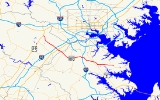
Maryland Route 100
Encyclopedia
Maryland Route 100 is a major east–west highway connecting U.S. Route 29
(US 29) in Ellicott City
(just north of Columbia
) and MD 177
(Mountain Road) in Pasadena
. MD 100 also connects to Interstate 95
(I-95), US 1
, the Baltimore-Washington Parkway
(MD 295), and I-97
. The highway connects Howard County
to the west with Anne Arundel County
and the Chesapeake Bay
to the east. MD 100 also provides access to the Baltimore-Washington International Airport (BWI) and the Arundel Mills
shopping mall
.
The eastern section of MD 100 in Anne Arundel County
is known as the Paul T. Pitcher Memorial Highway. The name comes in dedication to Paul T. Pitcher, an Anne Arundel County executive, who originally conceived the highway.
near Ellicott City
. There are then interchanges with MD 108
, MD 104
, Snowden River Parkway and MD 103
.
At the junction with I-95
, the road narrows to four lanes. Then MD 100 intersects with US 1
followed by an exit for Dorsey MARC station
. It then crosses the Baltimore-Washington Parkway
.
MD 100 then intersects with MD 170
(Telegraph Road) where the road becomes 6 lanes. Then the road junctions with Interstate 97
near Hanover
and reduces down to 4 lanes before crossing MD 2
. Between Glen Burnie
and Jacobsville
, MD 100 serves as a bypass for MD 177
, and has interchanges with MD 10
and MD 607
.
The road ends by merging back into MD 177
.
and the old Maryland Route 3
, now Interstate 97
. The second was built as a short spur between the newly constructed Interstate 95
and US 1
in Elkridge, Maryland
. The eastern section, originally known as the Mountain Road Bypass, was constructed east of Ritchie Highway in the late 1970s. MD 100 was completed west of I-97 to I-95, thereby connecting the two roads, in 1994, but it was not completed in its entirety to US 29 until November 1998. A portion of the route between Exit 1B-C and Exit 2 was constructed earlier than the rest as an at-grade boulevard, on the right-of-way of the future eastbound lanes; this section was eventually upgraded.
The construction of the route near Lake Waterford Road severed the original road between Baltimore and Annapolis
: the Baltimore-Annapolis Boulevard, signed in part as MD 648
. The physical road ends at a pair of dead ends on either side of the right-of-way; MD 648 follows Lake Waterford Road between Baltimore-Annapolis Boulevard and MD 177
before rejoining its original path.
The route is part of the Baltimore Outer Beltway
, a 3/4 circular beltway designed to provide a route parallel to the Baltimore Beltway. MD 100 represents the major portion that was built; US 29 between MD 100's terminus and US 29's own northern terminus at Maryland Route 99
, four miles (6 km) in length, is another portion. The Outer Beltway was projected beyond MD 99 to run through Howard
and Baltimore
Counties and intersect MD 140
, Interstate 83, US 1
, and Interstate 95
before terminating at US 40
northeast of Baltimore
.
U.S. Route 29 in Maryland
U.S. Route 29 is a north–south United States highway that runs for from the western suburbs of Baltimore, Maryland, to Pensacola, Florida. In the U.S. state of Maryland, US 29 is a major highway that emerges from Washington D.C. and runs north into eastern Montgomery County, stretching...
(US 29) in Ellicott City
Ellicott City, Maryland
Ellicott City is an unincorporated community and census-designated place in Howard County, Maryland, United States. It is part of the Baltimore-Washington Metropolitan Area. The population was 65,834 at the 2010 census. It is the county seat of Howard County...
(just north of Columbia
Columbia, Maryland
Columbia is a planned community that consists of ten self-contained villages, located in Howard County, Maryland, United States. It began with the idea that a city could enhance its residents' quality of life. Creator and developer James W. Rouse saw the new community in terms of human values, not...
) and MD 177
Maryland Route 177
Maryland Route 177 is a state route in Anne Arundel County, beginning at MD 2 in Pasadena and ending at Gibson Island. It is named 'Mountain Road' for its entire length.-Route description:...
(Mountain Road) in Pasadena
Pasadena, Maryland
Pasadena is a census-designated place in Anne Arundel County, Maryland, United States. The population was 12,093 at the 2000 census.-Geography:Pasadena is located at ....
. MD 100 also connects to Interstate 95
Interstate 95 in Maryland
Interstate 95 in Maryland is a major highway that runs diagonally from northeast to southwest, from Maryland's border with Delaware, to the Woodrow Wilson Bridge, briefly entering the District of Columbia before reaching Virginia...
(I-95), US 1
U.S. Route 1 in Maryland
U.S. Route 1 is the easternmost and longest of the major north–south routes of the United States Numbered Highway System, running from Key West, Florida to Fort Kent, Maine. In the U.S...
, the Baltimore-Washington Parkway
Baltimore-Washington Parkway
The Baltimore–Washington Parkway is a highway in the U.S. state of Maryland, running southwest from Baltimore to Washington, D.C. The road begins at an interchange with U.S. Route 50 and Maryland Route 201 near Cheverly in Prince George's County at the D.C...
(MD 295), and I-97
Interstate 97
Interstate 97 is an intrastate Interstate Highway located entirely within Anne Arundel County, Maryland, United States. It runs from Annapolis at the overlapped section of US 50, US 301, and the unsigned I-595 to Baltimore at the city's beltway...
. The highway connects Howard County
Howard County, Maryland
-2010:Whereas according to the 2010 U.S. Census Bureau:*62.2% White*17.5% Black*0.3% Native American*14.4% Asian*0.0% Native Hawaiian or Pacific Islander*3.6% Two or more races*2.0% Other races*5.8% Hispanic or Latino -2000:...
to the west with Anne Arundel County
Anne Arundel County, Maryland
Anne Arundel County is a county located in the U.S. state of Maryland. It is named for Anne Arundell , a member of the ancient family of Arundells in Cornwall, England and the wife of Cæcilius Calvert, 2nd Baron Baltimore. Its county seat is Annapolis, which is also the capital of the state...
and the Chesapeake Bay
Chesapeake Bay
The Chesapeake Bay is the largest estuary in the United States. It lies off the Atlantic Ocean, surrounded by Maryland and Virginia. The Chesapeake Bay's drainage basin covers in the District of Columbia and parts of six states: New York, Pennsylvania, Delaware, Maryland, Virginia, and West...
to the east. MD 100 also provides access to the Baltimore-Washington International Airport (BWI) and the Arundel Mills
Arundel Mills
Arundel Mills is a mall located in Hanover, Maryland and is now owned by Simon Property Group. With its GLA, it was the largest mall in Maryland, until the Westfield Annapolis Mall surpassed it with its 2007 expansion...
shopping mall
Shopping mall
A shopping mall, shopping centre, shopping arcade, shopping precinct or simply mall is one or more buildings forming a complex of shops representing merchandisers, with interconnecting walkways enabling visitors to easily walk from unit to unit, along with a parking area — a modern, indoor version...
.
The eastern section of MD 100 in Anne Arundel County
Anne Arundel County, Maryland
Anne Arundel County is a county located in the U.S. state of Maryland. It is named for Anne Arundell , a member of the ancient family of Arundells in Cornwall, England and the wife of Cæcilius Calvert, 2nd Baron Baltimore. Its county seat is Annapolis, which is also the capital of the state...
is known as the Paul T. Pitcher Memorial Highway. The name comes in dedication to Paul T. Pitcher, an Anne Arundel County executive, who originally conceived the highway.
Route description
The route begins as a six-lane divided expressway at US 29U.S. Route 29 in Maryland
U.S. Route 29 is a north–south United States highway that runs for from the western suburbs of Baltimore, Maryland, to Pensacola, Florida. In the U.S. state of Maryland, US 29 is a major highway that emerges from Washington D.C. and runs north into eastern Montgomery County, stretching...
near Ellicott City
Ellicott City, Maryland
Ellicott City is an unincorporated community and census-designated place in Howard County, Maryland, United States. It is part of the Baltimore-Washington Metropolitan Area. The population was 65,834 at the 2010 census. It is the county seat of Howard County...
. There are then interchanges with MD 108
Maryland Route 108
Maryland Route 108 is a suburban state highway in the central part of the U.S. state of Maryland, starting in Damascus and ending near Columbia.-Route description:...
, MD 104
Maryland Route 104
Maryland Route 104 is a state highway in the U.S. state of Maryland. Known as Waterloo Road, the state highway runs from MD 108 in Columbia north to MD 103 in Ellicott City. MD 104 connects MD 108, MD 103, and MD 100 in northeastern Howard County. The state highway was originally constructed...
, Snowden River Parkway and MD 103
Maryland Route 103
Maryland Route 103 is a state highway in the U.S. state of Maryland. The state highway runs from Parkway Drive South in Hanover northwest to St. Johns Lane in Ellicott City. MD 103 serves as the local complement to MD 100 from Hanover in northwestern Anne Arundel County through Dorsey to...
.
At the junction with I-95
Interstate 95 in Maryland
Interstate 95 in Maryland is a major highway that runs diagonally from northeast to southwest, from Maryland's border with Delaware, to the Woodrow Wilson Bridge, briefly entering the District of Columbia before reaching Virginia...
, the road narrows to four lanes. Then MD 100 intersects with US 1
U.S. Route 1 in Maryland
U.S. Route 1 is the easternmost and longest of the major north–south routes of the United States Numbered Highway System, running from Key West, Florida to Fort Kent, Maine. In the U.S...
followed by an exit for Dorsey MARC station
Dorsey (MARC station)
Dorsey is a passenger rail station on the MARC Camden Line between Washington, DC and Baltimore's Camden Station. The station is located at Exit 7 on Maryland Route 100, a.k.a.; the Paul T. Pitcher Memorial Highway...
. It then crosses the Baltimore-Washington Parkway
Baltimore-Washington Parkway
The Baltimore–Washington Parkway is a highway in the U.S. state of Maryland, running southwest from Baltimore to Washington, D.C. The road begins at an interchange with U.S. Route 50 and Maryland Route 201 near Cheverly in Prince George's County at the D.C...
.
MD 100 then intersects with MD 170
Maryland Route 170
Maryland Route 170 is a roughly 13-mile-long road in Anne Arundel County.-Route description:MD 170 begins at the intersection of MD 175 Annapolis Road and Piney Orchard Parkway, in Odenton. It runs north towards Severn, interchanging with MD 32 northwest of the town...
(Telegraph Road) where the road becomes 6 lanes. Then the road junctions with Interstate 97
Interstate 97
Interstate 97 is an intrastate Interstate Highway located entirely within Anne Arundel County, Maryland, United States. It runs from Annapolis at the overlapped section of US 50, US 301, and the unsigned I-595 to Baltimore at the city's beltway...
near Hanover
Hanover, Maryland
Hanover, Maryland is a locality in unincorporated northwestern Anne Arundel County, Maryland in the United States, located south of Baltimore near the Howard County line....
and reduces down to 4 lanes before crossing MD 2
Maryland Route 2
Maryland Route 2 is the longest state highway in the U.S. state of Maryland. The route runs from Solomons Island in Calvert County north to an intersection with U.S. Route 1 and U.S. Route 40 Truck in Baltimore...
. Between Glen Burnie
Glen Burnie, Maryland
Glen Burnie is a census-designated place in Anne Arundel County, Maryland, United States, and is a suburb of Baltimore. The population was 67,639 at the 2010 census...
and Jacobsville
Jacobsville, Maryland
Jacobsville is an unincorporated community in Anne Arundel County, Maryland, United States....
, MD 100 serves as a bypass for MD 177
Maryland Route 177
Maryland Route 177 is a state route in Anne Arundel County, beginning at MD 2 in Pasadena and ending at Gibson Island. It is named 'Mountain Road' for its entire length.-Route description:...
, and has interchanges with MD 10
Maryland Route 10
Maryland Route 10, also known as the Arundel Expressway, is a state highway and freeway in Anne Arundel County, Maryland, United States.-Route description:...
and MD 607
Maryland Route 607
Maryland Route 607 is a state highway in the U.S. state of Maryland. The state highway runs from the beginning of state maintenance south of MD 100 north to MD 173 in Jacobsville.-Route description:...
.
The road ends by merging back into MD 177
Maryland Route 177
Maryland Route 177 is a state route in Anne Arundel County, beginning at MD 2 in Pasadena and ending at Gibson Island. It is named 'Mountain Road' for its entire length.-Route description:...
.
History
Maryland Route 100 began in the 1970s as two separate roads, both having the MD 100 designation. The first was known as the Mountain Road Extension, stretching between Governor Ritchie HighwayMaryland Route 2
Maryland Route 2 is the longest state highway in the U.S. state of Maryland. The route runs from Solomons Island in Calvert County north to an intersection with U.S. Route 1 and U.S. Route 40 Truck in Baltimore...
and the old Maryland Route 3
Maryland Route 3
Maryland Route 3, also part of Robert Crain Highway, is the designation given to the former alignment of U.S. Route 301 from Bowie, Maryland, USA, to Baltimore. It is named for Robert Crain of Baltimore.-Route description:...
, now Interstate 97
Interstate 97
Interstate 97 is an intrastate Interstate Highway located entirely within Anne Arundel County, Maryland, United States. It runs from Annapolis at the overlapped section of US 50, US 301, and the unsigned I-595 to Baltimore at the city's beltway...
. The second was built as a short spur between the newly constructed Interstate 95
Interstate 95 in Maryland
Interstate 95 in Maryland is a major highway that runs diagonally from northeast to southwest, from Maryland's border with Delaware, to the Woodrow Wilson Bridge, briefly entering the District of Columbia before reaching Virginia...
and US 1
U.S. Route 1 in Maryland
U.S. Route 1 is the easternmost and longest of the major north–south routes of the United States Numbered Highway System, running from Key West, Florida to Fort Kent, Maine. In the U.S...
in Elkridge, Maryland
Elkridge, Maryland
Elkridge is a census-designated place in Howard County, Maryland, United States. The population was 22,042 at the 2000 census. Founded early in the 18th century, Elkridge is located at the confluence of three counties, the other two being Anne Arundel and Baltimore counties...
. The eastern section, originally known as the Mountain Road Bypass, was constructed east of Ritchie Highway in the late 1970s. MD 100 was completed west of I-97 to I-95, thereby connecting the two roads, in 1994, but it was not completed in its entirety to US 29 until November 1998. A portion of the route between Exit 1B-C and Exit 2 was constructed earlier than the rest as an at-grade boulevard, on the right-of-way of the future eastbound lanes; this section was eventually upgraded.
The construction of the route near Lake Waterford Road severed the original road between Baltimore and Annapolis
Annapolis, Maryland
Annapolis is the capital of the U.S. state of Maryland, as well as the county seat of Anne Arundel County. It had a population of 38,394 at the 2010 census and is situated on the Chesapeake Bay at the mouth of the Severn River, south of Baltimore and about east of Washington, D.C. Annapolis is...
: the Baltimore-Annapolis Boulevard, signed in part as MD 648
Maryland Route 648
Maryland Route 648 is a collection of state highways in the U.S. state of Maryland. These highways are sections of Baltimore–Annapolis Boulevard, the old alignment of MD 2 between Annapolis and Glen Burnie. These segments were bypassed when MD 2 was moved to Governor Ritchie Highway, a...
. The physical road ends at a pair of dead ends on either side of the right-of-way; MD 648 follows Lake Waterford Road between Baltimore-Annapolis Boulevard and MD 177
Maryland Route 177
Maryland Route 177 is a state route in Anne Arundel County, beginning at MD 2 in Pasadena and ending at Gibson Island. It is named 'Mountain Road' for its entire length.-Route description:...
before rejoining its original path.
The route is part of the Baltimore Outer Beltway
Baltimore Outer Beltway
The Baltimore Outer Beltway was a proposed freeway that would encircle parts of the Greater Baltimore area.Parts of it have been built as the following roads:*Maryland Route 100 *US 29 *Maryland Route 43...
, a 3/4 circular beltway designed to provide a route parallel to the Baltimore Beltway. MD 100 represents the major portion that was built; US 29 between MD 100's terminus and US 29's own northern terminus at Maryland Route 99
Maryland Route 99
Maryland Route 99 is a state highway in the U.S. state of Maryland. Known as Old Frederick Road, the state highway runs from MD 32 near West Friendship east to U.S. Route 29 in Ellicott City. MD 99 parallels the north side of Interstate 70 through a rural and suburban area in northeastern...
, four miles (6 km) in length, is another portion. The Outer Beltway was projected beyond MD 99 to run through Howard
Howard County, Maryland
-2010:Whereas according to the 2010 U.S. Census Bureau:*62.2% White*17.5% Black*0.3% Native American*14.4% Asian*0.0% Native Hawaiian or Pacific Islander*3.6% Two or more races*2.0% Other races*5.8% Hispanic or Latino -2000:...
and Baltimore
Baltimore County, Maryland
Baltimore County is a county located in the northern part of the US state of Maryland. In 2010, its population was 805,029. It is part of the Baltimore-Washington Metropolitan Area. Its county seat is Towson. The name of the county was derived from the barony of the Proprietor of the Maryland...
Counties and intersect MD 140
Maryland Route 140
Maryland Route 140 is a local long route in northern Maryland, United States.-Route description:MD 140 is known by various names depending on location; south of Reisterstown it is known as Reisterstown Road. Though Reisterstown itself is named after John Reister, the road is named after Jacob...
, Interstate 83, US 1
U.S. Route 1 in Maryland
U.S. Route 1 is the easternmost and longest of the major north–south routes of the United States Numbered Highway System, running from Key West, Florida to Fort Kent, Maine. In the U.S...
, and Interstate 95
Interstate 95 in Maryland
Interstate 95 in Maryland is a major highway that runs diagonally from northeast to southwest, from Maryland's border with Delaware, to the Woodrow Wilson Bridge, briefly entering the District of Columbia before reaching Virginia...
before terminating at US 40
U.S. Route 40 in Maryland
U.S. Route 40 in the U.S. state of Maryland runs from western Maryland to Cecil County in the state's northeastern corner. With a total length of over , it is the longest numbered highway in Maryland. Almost half of the road overlaps with Interstate 68 or Interstate 70, while the old alignment...
northeast of Baltimore
Baltimore
Baltimore is the largest independent city in the United States and the largest city and cultural center of the US state of Maryland. The city is located in central Maryland along the tidal portion of the Patapsco River, an arm of the Chesapeake Bay. Baltimore is sometimes referred to as Baltimore...
.
Junction list
| County | Location | Mile | Exit Exit number An exit number is a number assigned to a road junction, usually an exit from a freeway. It is usually marked on the same sign as the destinations of the exit, as well as a sign in the gore.... |
Destinations | Notes |
|---|---|---|---|---|
| Howard Howard County, Maryland -2010:Whereas according to the 2010 U.S. Census Bureau:*62.2% White*17.5% Black*0.3% Native American*14.4% Asian*0.0% Native Hawaiian or Pacific Islander*3.6% Two or more races*2.0% Other races*5.8% Hispanic or Latino -2000:... |
Ellicott City Ellicott City, Maryland Ellicott City is an unincorporated community and census-designated place in Howard County, Maryland, United States. It is part of the Baltimore-Washington Metropolitan Area. The population was 65,834 at the 2010 census. It is the county seat of Howard County... |
0.0 | ||
| 0.7 | 1A |  Long Gate Parkway to MD 103 Long Gate Parkway to MD 103Maryland Route 103 Maryland Route 103 is a state highway in the U.S. state of Maryland. The state highway runs from Parkway Drive South in Hanover northwest to St. Johns Lane in Ellicott City. MD 103 serves as the local complement to MD 100 from Hanover in northwestern Anne Arundel County through Dorsey to... |
no westbound exit | |
| 1.4 | 1B | Centre Park Drive | no eastbound exit; westbound entrance/exit signed as 1B-C | |
| 1C |  Executive Park Drive to MD 108 Executive Park Drive to MD 108Maryland Route 108 Maryland Route 108 is a suburban state highway in the central part of the U.S. state of Maryland, starting in Damascus and ending near Columbia.-Route description:... |
eastbound entrance and eastbound exit | ||
| 2.5 | 2 | |||
| Columbia Columbia, Maryland Columbia is a planned community that consists of ten self-contained villages, located in Howard County, Maryland, United States. It began with the idea that a city could enhance its residents' quality of life. Creator and developer James W. Rouse saw the new community in terms of human values, not... |
3 | Snowden River Parkway – Columbia Columbia, Maryland Columbia is a planned community that consists of ten self-contained villages, located in Howard County, Maryland, United States. It began with the idea that a city could enhance its residents' quality of life. Creator and developer James W. Rouse saw the new community in terms of human values, not... |
||
| 4 | ||||
| Elkridge Elkridge, Maryland Elkridge is a census-designated place in Howard County, Maryland, United States. The population was 22,042 at the 2000 census. Founded early in the 18th century, Elkridge is located at the confluence of three counties, the other two being Anne Arundel and Baltimore counties... |
5.4 | 5 | , Washington, D.C. Washington, D.C. Washington, D.C., formally the District of Columbia and commonly referred to as Washington, "the District", or simply D.C., is the capital of the United States. On July 16, 1790, the United States Congress approved the creation of a permanent national capital as permitted by the U.S. Constitution.... |
split into 5A and 5B |
| 6.1 | 6 | split into 6A and 6B on eastbound side only | ||
| 6.8 | 7 | Dorsey MARC Station Dorsey (MARC station) Dorsey is a passenger rail station on the MARC Camden Line between Washington, DC and Baltimore's Camden Station. The station is located at Exit 7 on Maryland Route 100, a.k.a.; the Paul T. Pitcher Memorial Highway... |
No trucks over five tons. | |
| Anne Arundel Anne Arundel County, Maryland Anne Arundel County is a county located in the U.S. state of Maryland. It is named for Anne Arundell , a member of the ancient family of Arundells in Cornwall, England and the wife of Cæcilius Calvert, 2nd Baron Baltimore. Its county seat is Annapolis, which is also the capital of the state... |
Dorsey Dorsey, Maryland Dorsey, Maryland, is a locality in eastern Howard County, Maryland, south of Elkridge, north of Savage, and close to the Anne Arundel County border and Baltimore-Washington International Airport... |
7.4 | 8 | Coca-Cola Drive to MD 103 Maryland Route 103 Maryland Route 103 is a state highway in the U.S. state of Maryland. The state highway runs from Parkway Drive South in Hanover northwest to St. Johns Lane in Ellicott City. MD 103 serves as the local complement to MD 100 from Hanover in northwestern Anne Arundel County through Dorsey to... |
| 8.1 | 9 | split into 9A and 9B | ||
| Hanover Hanover, Maryland Hanover, Maryland is a locality in unincorporated northwestern Anne Arundel County, Maryland in the United States, located south of Baltimore near the Howard County line.... |
9.1 | 10 | split into 10A and 10B | |
| 11.1 | 11 | |||
| 13.6 | 13 | split into 13A and 13B. To Baltimore via I-695 and I-895 | ||
| Glen Burnie Glen Burnie, Maryland Glen Burnie is a census-designated place in Anne Arundel County, Maryland, United States, and is a suburb of Baltimore. The population was 67,639 at the 2010 census... |
14.2 | 14 | eastbound exit and westbound entrance | |
| 15.6 | 15 | Oakwood Road | ||
| 16.8 | 16 | split into 16A and 16B; 16B on westbound provides access via MD 177 | ||
| 17.4 | 17 | westbound exit and eastbound entrance | ||
| 18.3 | 18 | eastbound exit and westbound entrance | ||
| 19.8 | 19 | Catherine Avenue | eastbound exit and westbound entrance | |
| 20.6 | 20 |  Edwin Raynor Boulevard to MD 173 Edwin Raynor Boulevard to MD 173Maryland Route 173 Maryland Route 173 is a state highway in the U.S. state of Maryland. Known for most of its length as Fort Smallwood Road, the state highway runs from Fort Smallwood Park near Fairview north to MD 2 in the Brooklyn neighborhood of Baltimore... (Fort Smallwood Road) |
eastbound exit and westbound entrance; MD 100 becomes four-lane at-grade expressway | |
| Jacobsville Jacobsville, Maryland Jacobsville is an unincorporated community in Anne Arundel County, Maryland, United States.... |
21.2 | |||
| Magothy Beach Road | ||||
| 22.1 | eastbound exit and westbound entrance; eastern terminus of MD 100 |