
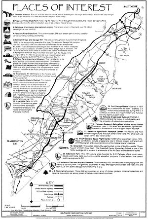
Baltimore-Washington Parkway
Encyclopedia
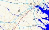
The Baltimore–Washington Parkway (also referred to as the B–W Parkway) is a highway
in the U.S. state
of Maryland
, running southwest from Baltimore to Washington, D.C.
The road begins at an interchange with U.S. Route 50
and Maryland Route 201
near Cheverly
in Prince George's County
at the D.C. border, and continues northeast as a parkway
maintained by the National Park Service
(NPS) to Maryland Route 175
near Fort Meade, serving many federal institutions. This portion of the parkway is dedicated to Gladys Noon Spellman, a representative of Maryland's 5th congressional district
, and has the hidden Maryland Route 295 designation. Commercial vehicles, including trucks, are prohibited within this stretch. After leaving park service boundaries the highway is maintained by the state and signed with the MD 295 designation. This section of the parkway passes near Baltimore–Washington International Thurgood Marshall Airport. Upon entering Baltimore, the Baltimore Department of Transportation takes over maintenance of the road and it continues north to an interchange with I-95. Here, the Baltimore–Washington Parkway ends and MD 295 continues north unsigned on Russell Street, which carries the route north into downtown Baltimore
. In downtown Baltimore, MD 295 follows Paca Street northbound and Greene Street southbound before ending at U.S. Route 40
.
Plans for a parkway linking Baltimore and Washington date back to Pierre Charles L'Enfant
's original layout for Washington D.C. in the 18th century but did not fully develop until the 1920s. Major reasons surrounding the need for a parkway included high accident rates on adjacent U.S. Route 1
and defense purposes before World War II
. In the mid-1940s, plans for the design of the parkway were finalized and construction began in 1947 for the state-maintained portion and in 1950 for the NPS-maintained segment. The entire parkway opened to traffic in stages between 1950 and 1954. Following the completion of the B–W Parkway, suburban growth took place in both Washington and Baltimore. In the 1960s and the 1970s, there were plans to give the segment of the parkway owned by the NPS to the state and make it a part of Interstate 295 and possibly I-95; however, they never came through and the entire road is today designated as MD 295, despite only being signed on the state portion. Between the 1980s and the 2000s, the NPS portion of the road was modernized and a part of signed MD 295 is in the process of being widened from four to six lanes, with more widening and a new interchange along this segment planned for the future.
just outside the Washington, D.C.
boundary at Tuxedo, Maryland
that is maintained by the Maryland State Highway Administration
. Two routes converge at the southern and western ends of the interchange: U.S. Route 50
, which heads west into Washington, D.C. to become New York Avenue
; and Maryland Route 201
, which begins at the D.C. line along the northernmost tip of the Kenilworth Avenue Freeway (which continues into the District of Columbia as D.C. Route 295). US 50 continues east from this interchange as the John Hanson Highway, a freeway, and MD 201 continues north on Kenilworth Avenue, a surface road that closely parallels the B–W Parkway to the east past the interchange.
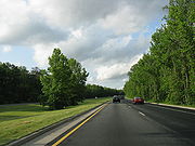
 The portion of the B–W Parkway between the southern terminus and Maryland Route 175
is maintained by the National Park Service
(NPS). It continues north as a six-lane 45 mph (72.4 km/h) limited-access parkway with the secret Maryland Route 295 designation, containing brown signs featuring the Clarendon
typeface. Along this section of the parkway, commercial vehicles such as truck
s are prohibited; however, bus
es and limousine
s are allowed. The parkway heads through wooded surroundings near industrial areas and passes over MD 201, where there is a ramp from southbound MD 201 to the southbound B–W Parkway. It continues northeast, passing near Prince George's Hospital Center, to interchanges with Maryland Route 202
(Landover Road) in Cheverly
and with Maryland Route 450
(Annapolis Road) in Bladensburg
near the former Capital Plaza Mall
. Bladensburg itself is a historical waterfront town that consists of houses dating back to the mid-18th century. It continues north as a four-lane 55 mph (88.5 km/h) road with a wide, tree-filled median, and passes through woodland, skirting residential neighborhoods hidden by the trees. The road has a junction with Maryland Route 410
(Riverdale Road) west of New Carrollton
. This route provides access to the towns of Riverdale Park
, which features an 1801 mansion named Riversdale surrounded by suburban development, and Hyattsville
, which has buildings dating back to the railroad days of the 1870s and the streetcar and automobile days of the early 20th century. North of here, the route runs near more residences before entering Greenbelt
, a suburban garden community built as a model "green town" during the New Deal
program in the 1930s, and Greenbelt Park
, a park under the jurisdiction of the NPS that has the nearest public camping area to Washington, D.C. In the northeastern corner of the park, the Baltimore–Washington Parkway comes to an interchange with Interstate 95
and Interstate 495 (the Capital Beltway). This interchange is the only place where the park service has used green signs compliant with the Manual on Uniform Traffic Control Devices
(MUTCD).
Just past the Capital Beltway, the route heads into the heart of the city of Greenbelt, having an interchange with Maryland Route 193
(Greenbelt Road). The headquarters of the U.S. Park Police, which patrol this portion of the parkway, is located off this exit along MD 193. MD 193 provides access to College Park
, which is home to the College Park Airport
, a 1909 airport where the Wright Brothers
taught the U.S. Army how to fly an airplane, and the University of Maryland, College Park
, a public educational institution established in 1862. At the northern edge of the town, the route has employee-only access to the Goddard Space Flight Center
, the first NASA
space flight center opened in 1958 that contributed majorly to many space missions; from here, the route then enters the Beltsville Agricultural Research Center, the largest agricultural research center in the world owned by the United States Department of Agriculture
. The parkway's only interchange within the center is at Powder Mill Road, south of Capitol College
.
 Outside the Beltsville Agricultural Research Center, the parkway comes to Maryland Route 197
(Laurel–Bowie Road) south of Laurel
. Near this exit of the parkway is the Montpelier Mansion, a Georgian mansion built by Major Thomas Snowden in 1783. Past MD 197, the road passes through the western edge of the Patuxent National Wildlife Research Refuge
, a wildlife center established in 1936 by President Franklin D. Roosevelt
, crossing the Patuxent River
into Anne Arundel County
. Here the parkway continues northeast through dense woodland and comes to the exit for Maryland Route 198
(Fort Meade Road) to the east of Laurel, which itself is a suburb that originated in the 1830s as a mill town that contains many historical sites such as the Laurel Railroad Station
(still used today by MARC Train
), a 1844 Queen Anne house, and an 1840s millworkers house that is home to the Laurel Museum
. Continuing north, the parkway encounters Maryland Route 32
(Savage Road) near Fort Meade
. MD 32 offers northbound travelers direct access into the fort and to the National Security Agency
, while the next interchange, another employee-only access road into Fort Meade, features only a southbound exit and northbound entrance. Fort Meade itself is a military installation opened in 1917 that trained 3.5 million troops during World War II
and is still a major fort. To the west of the parkway off MD 32 is the Savage Mill
, which was an operating cotton mill from 1822 to 1947 and is currently an antique mall, and the Bollman Truss Railroad Bridge
, an 1869 cast and wrought iron bridge along the Baltimore & Ohio Railroad (now CSX) line between Baltimore and Washington D.C. After this interchange, the road continues to a cloverleaf interchange with Maryland Route 175
(Jessup Road), where NPS maintenance of the parkway comes to an end at the south end of the interchange.
shopping mall at a dumbbell interchange. Past this interchange, MD 295 comes to a cloverleaf interchange with Maryland Route 100
. Continuing northeast, the route curves to the northwest of Baltimore–Washington International Airport (the largest airport in Maryland), passing near an industrial park before reaching Interstate 195
, the main access road to the airport. Within this interchange, before passing under I-195, the road crosses over Amtrak
's Northeast Corridor
. I-195 westbound provides access from the Baltimore–Washington Parkway to the Thomas Viaduct
, which carries the B&O railroad line over the Patapsco River
, and Patapsco Valley State Park
, a 14000 acres (56.7 km²) state park that preserves the valley of the Patapsco River for recreational purposes.
Still on a northeast track, the route intersects West Nursery Road near Linthicum
, adjacent to the BWI Hotel District. Past West Nursery Road, the road meets Interstate 695
(the Baltimore Beltway) at a full cloverleaf interchange. Turning north, the route widens to six lanes and passes under Maryland Route 168
(Nursery Road) before crossing the Patapsco River into Baltimore County
. Upon crossing into Baltimore County, MD 295 reaches a partial interchange with Interstate 895
(Harbor Tunnel Thruway), with access from northbound MD 295 to northbound I-895 and from southbound I-895 to southbound MD 295. Past I-895, the road continues through wooded surrounding with residential developments behind the trees, before entering the city of Baltimore.
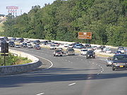
In Baltimore, MD 295 continues as a limited-access freeway maintained by the Baltimore Department of Transportation, still surrounded by trees with urban residential and industrial neighborhoods nearby and interchanging with Maryland Route 648
(Annapolis Road) and Waterview Avenue just beyond the city line. Now running due north, the parkway soon reaches its northern terminus at Interstate 95
, where MD 295 downgrades from a limited-access freeway to a six-lane 35 mph (56.3 km/h) undivided city street called Russell Street.
 MD 295 continues northeast on Russell Street, where it is unsigned for the remainder of the route, through a mix of industrial and commercial areas before turning into a divided highway
and passing to the west of M&T Bank Stadium
, where the Baltimore Ravens
of the National Football League
play. Past here, the road features an interchange with Martin Luther King Jr. Boulevard, which becomes Interstate 395
south of Russell Street. After this interchange, MD 295 runs west of Oriole Park at Camden Yards
, home to Major League Baseball
's Baltimore Orioles
, as a four-lane divided street. Immediately after Camden Yards, MD 295 splits into a one-way pair
at the intersection with Washington Boulevard with northbound traffic following Paca Street and southbound traffic following Greene Street. Along the one-way pair, the route intersects many major streets in downtown Baltimore
, including Pratt Street
, Lombard Street
, Baltimore Street, Fayette Street, and Saratoga Street.
Greene Street passes the University of Maryland Medical Center
between Lombard Street and Baltimore Street, the Baltimore VA Medical Center between Baltimore Street and Fayette Street, and Westminster Hall and Burying Ground
at the corner of Fayette Street. Paca Street passes by the Sonneborn Building
north of Pratt Street; the Heiser, Rosenfeld, and Strauss Buildings
north of Lombard Street; the historic Paca Street Firehouse
and Sanitary Laundry Company Building
just north of the intersection with Fayette Street; and Lexington Market
at the intersection with Lexington Street. MD 295 officially ends at U.S. Route 40
, which follows Mulberry Street eastbound and Franklin Street westbound, in downtown Baltimore. Maryland Route 129
continues north from the northern terminus of MD 295, following Paca Street northbound and Pennsylvania Avenue southbound.
 Plans for a parkway connecting Baltimore and Washington date back to the 1920s as a part of a system that was initially included in Pierre Charles L'Enfant
's layout of Washington, D.C from the 18th century. In 1924, Harry W. Nice, who would later become Governor of Maryland
, called for the parkway to be constructed.
Early proposals made by the National Capital Park and Planning Commission
involved a route that followed U.S. Route 1
north to MD 198, then east to Fort Meade, but lack of funding led to simpler plans to widen US 1 instead. During the 1930s, the New Deal
programs promulgated by President Franklin Roosevelt led to a heightened awareness of the parkway proposals; a 1937 report by the Maryland State Planning Commission increased awareness further. Increasing accident levels on US 1 (which was called one of the deadliest roads in the world at the time) along with awareness of the need to mobilize national defense before World War II
provided additional motivation for construction of the parkway.
In 1942, the Bureau of Public Roads began the process to start the construction design for the parkway. Federal and state officials commissioned the firm J.E. Greiner to create designs for the parkway, which included a large Y-junction at the southern terminus to connect with New York Avenue and the proposed Anacostia Freeway. Meanwhile, the northern end included a similar wye, with one end running to US 40 (Franklin Street) and the other end crossing the Inner Harbor
, but this was modified in 1945 to the current configuration.
, Severn
, Bowie
, and Greenbelt
. In addition, the road became a prime commuting route into both Washington and Baltimore, leading to suburban growth that would eventually cause the two distinct cities to merge into one large metropolitan area.
In 1963, the State Roads Commission, the National Park Service, and the Bureau of Public Roads (the predecessor of the Federal Highway Administration
) (FHWA) created tentative plans to transfer the NPS segment of the parkway to the state of Maryland, who would then rebuild it to modern freeway standards, with trucks and buses permitted throughout. The plan collapsed due to the state's reluctance to spend the money necessary to reconstruct the parkway, which was one of the most dangerous roads in the NPS road system.
In 1968, the State Roads Commission proposed to the FHWA that the parkway be included in the Interstate Highway System
and designated Interstate 295 (in anticipation of the completion of the parallel-running I-95 that occurred in 1971). The designation was granted in 1969, but later withdrawn from all except the current portion signed as I-295 due to lack of funds available to modernize the route. As a result of the withdrawal of the Interstate designation, the parkway remained an unnumbered road south of I-695 while the portion north of there became a part of Maryland Route 3
by 1975. Despite this setback, however, plans still existed to widen the parkway to six or even eight lanes. Even though the 1970 Federal Highway Act provided $65 million (equivalent to $ in ) for this purpose, funding was insufficient to execute these projects. The cancellation of the North Central Freeway and the Northeast Freeway
(I-95's routing between New York Avenue and the College Park Interchange
) offered a chance for modernization, as plans existed to route I-95 via the B–W Parkway; however, this did not happen and trucks were banned from the parkway again.
By 1973, MD 3 was designated along the Baltimore–Washington Expressway between I-695 and Monroe Street in Baltimore. Maryland Route 295 was designated along the state-maintained portions of the expressway, replacing the MD 3 designation between I-695 and Monroe Street, by 1981. By the 1990s, the portion of the road known as the Baltimore–Washington Expressway became known as the Baltimore–Washington Parkway.
In the mid-1980s, the National Park Service, along with the Federal Highway Administration, began a reconstruction of the NPS segment to modernize the road, including the improvement of several interchanges. Around 2002, the federal government completed the project with the reconstruction of the MD 197 interchange.
who represented Maryland's 5th congressional district
from January 3, 1975, to January 3, 1981, after a bill introduced into the United States Senate
by Senator Paul Sarbanes
was signed into law. Gladys Noon Spellman was an educator in Prince George's County
and chairperson of the National Mental Health Study Center before becoming the first woman to serve on the county’s Board of Commissioners. She suffered a heart attack that ended her congressional career on October 13, 1980, leaving her in a coma until her death on June 19, 1988. On May 9, 1991, the Baltimore–Washington Parkway was listed on the National Register of Historic Places
.
being built at Maryland Route 198 over the B–W Parkway just east of Laurel collapsed during rush hour, injuring fourteen motorists and construction workers. The incident was blamed on faulty scaffolding used to support the uncompleted span. On July 9, 2005, a sinkhole opened beneath the parkway at a construction site, leading to the complete closure of the northbound roadway. The sinkhole was filled with concrete to shore up the roadbed and prevent further collapse; the U.S. Army Corps of Engineers attempted to expedite repairs, but the route remained closed until the next day. On August 24, 2007, both directions of the parkway were closed when chunks of concrete fell from the overpass at MD 193 (Greenbelt Road) onto the northbound lanes.
, a single-point urban interchange
, and a modified cloverleaf interchange. The $24 million project is still in the planning stages and is expected to conclude in 2011.
!County
!Location
!Mile
!Destinations
!Notes
|-
|rowspan=10|Prince George's
|
|0.00
| – Washington
, Annapolis
, Richmond
|
|-
|
|0.79
|
|Northbound exit, southbound entrance
|-
|rowspan=2|Bladensburg
|1.65
|
|
|-
|1.97
|
|
|-
|
|3.63
|
|
|-
|Greenbelt Park
|5.99
|, Richmond
|
|-
|rowspan=2|Greenbelt
|6.36
|
|
|-
|7.53
|Goddard Space Flight Center
(employees only)
|
|-
|Beltsville ARC
|9.65
|Powder Mill Road – Beltsville
|
|-
|
|11.51
|
|
|-
|rowspan=10|Anne Arundel
|
|14.86
|
|
|-
|
|16.61
|
|Northbound exit to MD 32 East Includes direct access to Fort Meade through Canine Road interchange; Canine Road interchange provides the only public access to Colony Seven Road and the National Cryptologic Museum
|-
|
|17.04
|NSA (employees only)
|Southbound exit, northbound entrance
|-
|
|18.56
|colspan=5 align="center"|NPS
/MDSHA
jurisdictional boundary
|-
|
|18.81
|
|
|-
|
|20.05
|Arundel Mills Boulevard (MD 713F) east – Arundel Mills
|
|-
|
|21.31
|
|
|-
|
|24.21
|
|Former MD 46
|-
|
|25.42
|West Nursery Road - BWI Hotel District
|
|-
|Linthicum
|26.59
|
|
|-
|rowspan=2|Baltimore
|
|27.66
|
|Northbound exit, southbound entrance, no exit before toll
|-
|
|28.88
|colspan=5 align="center"|Baltimore City line, MDSHA/Baltimore DOT jurisdictional boundary
|-
|rowspan=10 colspan=2|Baltimore City
|29.89
|
|
|-
|30.11
|Westport
|
|-
|30.53
| – New York
, Washington
|Northern terminus of B-W Parkway, MD 295 becomes unsigned and follows at-grade Russell Street
|-
|31.52
|
|Northbound exit, southbound entrance
|-
|31.84
|Washington Boulevard west
|MD 295 splits into one-way pair
|-
|31.92
|W. Pratt Street
– Baltimore Inner Harbor
|One-way eastbound
|-
|32.01
|W Lombard Street
– B&O Railroad Museum
|One-way westbound
|-
|32.21
|Fayette Street
|One-way westbound
|-
|32.45
|
|One-way eastbound
|-
|32.52
|
|US 40 is one-way westbound, northern terminus of MD 295
Highway
A highway is any public road. In American English, the term is common and almost always designates major roads. In British English, the term designates any road open to the public. Any interconnected set of highways can be variously referred to as a "highway system", a "highway network", or a...
in the U.S. state
U.S. state
A U.S. state is any one of the 50 federated states of the United States of America that share sovereignty with the federal government. Because of this shared sovereignty, an American is a citizen both of the federal entity and of his or her state of domicile. Four states use the official title of...
of Maryland
Maryland
Maryland is a U.S. state located in the Mid Atlantic region of the United States, bordering Virginia, West Virginia, and the District of Columbia to its south and west; Pennsylvania to its north; and Delaware to its east...
, running southwest from Baltimore to Washington, D.C.
Washington, D.C.
Washington, D.C., formally the District of Columbia and commonly referred to as Washington, "the District", or simply D.C., is the capital of the United States. On July 16, 1790, the United States Congress approved the creation of a permanent national capital as permitted by the U.S. Constitution....
The road begins at an interchange with U.S. Route 50
U.S. Route 50 in Maryland
U.S. Route 50 is a major east–west route of the U.S. Highway system, stretching just over from Ocean City, Maryland on the Atlantic Ocean to West Sacramento, California. In the U.S. state of Maryland, US 50 exists in two sections. The longer of these serves as a major route connecting...
and Maryland Route 201
Maryland Route 201
-Route description:MD 201 begins at a large hybrid cloverleaf just outside the D.C. boundary at Tuxedo, Maryland that is maintained by the Maryland State Highway Administration...
near Cheverly
Cheverly, Maryland
Cheverly is a town in central Maryland, just outside Washington, D.C., United States. The town was founded in 1918 and it was incorporated in 1931. Cheverly had 6,433 residents as of the 2000 Census....
in Prince George's County
Prince George's County, Maryland
Prince George's County is a county located in the U.S. state of Maryland, immediately north, east, and south of Washington, DC. As of 2010, it has a population of 863,420 and is the wealthiest African-American majority county in the nation....
at the D.C. border, and continues northeast as a parkway
Parkway
The term parkway has several distinct principal meanings and numerous synonyms around the world, for either a type of landscaped area or a type of road.Type of landscaped area:...
maintained by the National Park Service
National Park Service
The National Park Service is the U.S. federal agency that manages all national parks, many national monuments, and other conservation and historical properties with various title designations...
(NPS) to Maryland Route 175
Maryland Route 175
-Annapolis Road:MD 175 begins at MD 3, just south of the latter's northern terminus at Interstate 97, known as Annapolis Road. It runs west as a two-lane suburban highway, passing through local neighborhoods and south of Arundel High School before widening into a four-lane suburban arterial south...
near Fort Meade, serving many federal institutions. This portion of the parkway is dedicated to Gladys Noon Spellman, a representative of Maryland's 5th congressional district
Maryland's 5th congressional district
Maryland's 5th congressional district comprises all of Charles, St. Mary's, and Calvert Counties, as well as portions of Prince George's and Anne Arundel Counties. The district is currently represented by Democrat Steny Hoyer, the House Minority Whip....
, and has the hidden Maryland Route 295 designation. Commercial vehicles, including trucks, are prohibited within this stretch. After leaving park service boundaries the highway is maintained by the state and signed with the MD 295 designation. This section of the parkway passes near Baltimore–Washington International Thurgood Marshall Airport. Upon entering Baltimore, the Baltimore Department of Transportation takes over maintenance of the road and it continues north to an interchange with I-95. Here, the Baltimore–Washington Parkway ends and MD 295 continues north unsigned on Russell Street, which carries the route north into downtown Baltimore
Downtown Baltimore
Downtown Baltimore is the section of Baltimore traditionally bounded by Martin Luther King, Jr. Boulevard to the west, Mt. Royal Avenue to the north, President Street to the east and the Inner Harbor area to the south. It consists of four neighborhoods: Westside, City Centre, Inner Harbor, and...
. In downtown Baltimore, MD 295 follows Paca Street northbound and Greene Street southbound before ending at U.S. Route 40
U.S. Route 40 in Maryland
U.S. Route 40 in the U.S. state of Maryland runs from western Maryland to Cecil County in the state's northeastern corner. With a total length of over , it is the longest numbered highway in Maryland. Almost half of the road overlaps with Interstate 68 or Interstate 70, while the old alignment...
.
Plans for a parkway linking Baltimore and Washington date back to Pierre Charles L'Enfant
Pierre Charles L'Enfant
Pierre Charles L'Enfant was a French-born American architect and civil engineer best known for designing the layout of the streets of Washington, D.C..-Early life:...
's original layout for Washington D.C. in the 18th century but did not fully develop until the 1920s. Major reasons surrounding the need for a parkway included high accident rates on adjacent U.S. Route 1
U.S. Route 1 in Maryland
U.S. Route 1 is the easternmost and longest of the major north–south routes of the United States Numbered Highway System, running from Key West, Florida to Fort Kent, Maine. In the U.S...
and defense purposes before World War II
World War II
World War II, or the Second World War , was a global conflict lasting from 1939 to 1945, involving most of the world's nations—including all of the great powers—eventually forming two opposing military alliances: the Allies and the Axis...
. In the mid-1940s, plans for the design of the parkway were finalized and construction began in 1947 for the state-maintained portion and in 1950 for the NPS-maintained segment. The entire parkway opened to traffic in stages between 1950 and 1954. Following the completion of the B–W Parkway, suburban growth took place in both Washington and Baltimore. In the 1960s and the 1970s, there were plans to give the segment of the parkway owned by the NPS to the state and make it a part of Interstate 295 and possibly I-95; however, they never came through and the entire road is today designated as MD 295, despite only being signed on the state portion. Between the 1980s and the 2000s, the NPS portion of the road was modernized and a part of signed MD 295 is in the process of being widened from four to six lanes, with more widening and a new interchange along this segment planned for the future.
NPS segment
The parkway begins at a large hybrid cloverleafCloverleaf interchange
A cloverleaf interchange is a two-level interchange in which left turns, reverse direction in left-driving regions, are handled by ramp roads...
just outside the Washington, D.C.
Washington, D.C.
Washington, D.C., formally the District of Columbia and commonly referred to as Washington, "the District", or simply D.C., is the capital of the United States. On July 16, 1790, the United States Congress approved the creation of a permanent national capital as permitted by the U.S. Constitution....
boundary at Tuxedo, Maryland
Tuxedo, Maryland
Tuxedo is an unincorporated community in Prince George's County, Maryland, United States.-History:Scattered settlement in Tuxedo appeared along the Baltimore and Potomac Railroad by 1886, according to historic maps...
that is maintained by the Maryland State Highway Administration
Maryland State Highway Administration
The Maryland State Highway Administration is the state agency responsible for maintaining Maryland numbered highways outside of Baltimore City...
. Two routes converge at the southern and western ends of the interchange: U.S. Route 50
U.S. Route 50 in Maryland
U.S. Route 50 is a major east–west route of the U.S. Highway system, stretching just over from Ocean City, Maryland on the Atlantic Ocean to West Sacramento, California. In the U.S. state of Maryland, US 50 exists in two sections. The longer of these serves as a major route connecting...
, which heads west into Washington, D.C. to become New York Avenue
New York Avenue (Washington, D.C.)
New York Avenue is one of the diagonal avenues radiating from the White House in Washington, D.C. It is a major east-west route in the city's Northwest and Northeast quadrants and connects downtown with points east and north of the city via Cheverly, Maryland, the John Hanson Highway and the...
; and Maryland Route 201
Maryland Route 201
-Route description:MD 201 begins at a large hybrid cloverleaf just outside the D.C. boundary at Tuxedo, Maryland that is maintained by the Maryland State Highway Administration...
, which begins at the D.C. line along the northernmost tip of the Kenilworth Avenue Freeway (which continues into the District of Columbia as D.C. Route 295). US 50 continues east from this interchange as the John Hanson Highway, a freeway, and MD 201 continues north on Kenilworth Avenue, a surface road that closely parallels the B–W Parkway to the east past the interchange.
Maryland Route 175
-Annapolis Road:MD 175 begins at MD 3, just south of the latter's northern terminus at Interstate 97, known as Annapolis Road. It runs west as a two-lane suburban highway, passing through local neighborhoods and south of Arundel High School before widening into a four-lane suburban arterial south...
is maintained by the National Park Service
National Park Service
The National Park Service is the U.S. federal agency that manages all national parks, many national monuments, and other conservation and historical properties with various title designations...
(NPS). It continues north as a six-lane 45 mph (72.4 km/h) limited-access parkway with the secret Maryland Route 295 designation, containing brown signs featuring the Clarendon
Clarendon (typeface)
Clarendon is an English slab-serif typeface that was created in England by Robert Besley for Thorowgood and Co. , a type company formerly known as the Fann Street Foundry until approximately 1838. The font was published in 1845 after Besley, an employee of the foundry since 1826, was made a partner...
typeface. Along this section of the parkway, commercial vehicles such as truck
Truck
A truck or lorry is a motor vehicle designed to transport cargo. Trucks vary greatly in size, power, and configuration, with the smallest being mechanically similar to an automobile...
s are prohibited; however, bus
Bus
A bus is a road vehicle designed to carry passengers. Buses can have a capacity as high as 300 passengers. The most common type of bus is the single-decker bus, with larger loads carried by double-decker buses and articulated buses, and smaller loads carried by midibuses and minibuses; coaches are...
es and limousine
Limousine
A limousine is a luxury sedan or saloon car, especially one with a lengthened wheelbase or driven by a chauffeur. The chassis of a limousine may have been extended by the manufacturer or by an independent coachbuilder. These are called "stretch" limousines and are traditionally black or white....
s are allowed. The parkway heads through wooded surroundings near industrial areas and passes over MD 201, where there is a ramp from southbound MD 201 to the southbound B–W Parkway. It continues northeast, passing near Prince George's Hospital Center, to interchanges with Maryland Route 202
Maryland Route 202
Maryland Route 202 is a north–south state highway in Prince George's County within the U.S. state of Maryland. MD 202 travels through many communities in central Prince George's County, and is known as Maryland Route 202 (MD 202) is a north–south state highway in Prince George's...
(Landover Road) in Cheverly
Cheverly, Maryland
Cheverly is a town in central Maryland, just outside Washington, D.C., United States. The town was founded in 1918 and it was incorporated in 1931. Cheverly had 6,433 residents as of the 2000 Census....
and with Maryland Route 450
Maryland Route 450
Maryland Route 450 is a state highway in the U.S. state of Maryland. The state highway runs from U.S. Route 1 Alternate in Bladensburg east to US 50, US 301, and MD 2 near Annapolis. MD 450 is the original alignment of US 50 in Prince George's and Anne Arundel Counties...
(Annapolis Road) in Bladensburg
Bladensburg, Maryland
Bladensburg is a town in Prince George's County, Maryland, United States. The population was 7,661 at the 2000 census.Bladensburg is from central Washington, DC...
near the former Capital Plaza Mall
Capital Plaza Mall
Capital Plaza Mall was a shopping mall located at the intersection of Annapolis Road and the Baltimore-Washington Parkway in Landover Hills, Maryland. It was built between 1961 and 1963, as a regional shopping center to serve the Bladensburg and Landover area of suburban Washington, D.C...
. Bladensburg itself is a historical waterfront town that consists of houses dating back to the mid-18th century. It continues north as a four-lane 55 mph (88.5 km/h) road with a wide, tree-filled median, and passes through woodland, skirting residential neighborhoods hidden by the trees. The road has a junction with Maryland Route 410
Maryland Route 410
Maryland Route 410 is a state highway in the U.S. state of Maryland. Known for most of its length as East–West Highway, the highway runs from MD 355 in Bethesda east to Pennsy Drive in Landover Hills...
(Riverdale Road) west of New Carrollton
New Carrollton, Maryland
New Carrollton is a city located in central Prince George's County, Maryland, in the United States. As of the 2000 census, population was 12,589.New Carrollton is 12.11 miles from central Washington, DC....
. This route provides access to the towns of Riverdale Park
Riverdale Park, Maryland
Riverdale Park is a town in Prince George's County, Maryland, United States. The population was 6,690 at the 2000 census.-Geography:Riverdale Park is located at ....
, which features an 1801 mansion named Riversdale surrounded by suburban development, and Hyattsville
Hyattsville, Maryland
Hyattsville is a city in Prince George's County, Maryland, United States. The population was 17,557 at the 2000 census.- History :The city was named for its founder, Christopher Clark Hyatt. He purchased his first parcel of land in the area in March 1845...
, which has buildings dating back to the railroad days of the 1870s and the streetcar and automobile days of the early 20th century. North of here, the route runs near more residences before entering Greenbelt
Greenbelt, Maryland
Greenbelt is a city in Prince George's County, Maryland, United States. Contained within today's City of Greenbelt is the historic planned community now known locally as "Old Greenbelt" and designated as the Greenbelt Historic District...
, a suburban garden community built as a model "green town" during the New Deal
New Deal
The New Deal was a series of economic programs implemented in the United States between 1933 and 1936. They were passed by the U.S. Congress during the first term of President Franklin D. Roosevelt. The programs were Roosevelt's responses to the Great Depression, and focused on what historians call...
program in the 1930s, and Greenbelt Park
Greenbelt Park
Greenbelt Park, located in Greenbelt, Maryland, is managed by the United States National Park Service. The forested park lies approximately 10 miles northeast of Washington, D.C., and is situated just within the Capital Beltway . The park land was originally intended to form part of the green...
, a park under the jurisdiction of the NPS that has the nearest public camping area to Washington, D.C. In the northeastern corner of the park, the Baltimore–Washington Parkway comes to an interchange with Interstate 95
Interstate 95 in Maryland
Interstate 95 in Maryland is a major highway that runs diagonally from northeast to southwest, from Maryland's border with Delaware, to the Woodrow Wilson Bridge, briefly entering the District of Columbia before reaching Virginia...
and Interstate 495 (the Capital Beltway). This interchange is the only place where the park service has used green signs compliant with the Manual on Uniform Traffic Control Devices
Manual on Uniform Traffic Control Devices
The Manual on Uniform Traffic Control Devices is a document issued by the Federal Highway Administration of the United States Department of Transportation to specify the standards by which traffic signs, road surface markings, and signals are designed, installed, and used...
(MUTCD).
Just past the Capital Beltway, the route heads into the heart of the city of Greenbelt, having an interchange with Maryland Route 193
Maryland Route 193
Maryland Route 193 is a state highway in the U.S. state of Maryland. Known for most of its length as University Boulevard and Greenbelt Road, the state highway runs from MD 185 in Kensington east to MD 202 in Greater Upper Marlboro...
(Greenbelt Road). The headquarters of the U.S. Park Police, which patrol this portion of the parkway, is located off this exit along MD 193. MD 193 provides access to College Park
College Park, Maryland
College Park is a city in Prince George's County, Maryland, USA. The population was 30,413 at the 2010 census. It is best known as the home of the University of Maryland, College Park, and since 1994 the city has also been home to the "Archives II" facility of the U.S...
, which is home to the College Park Airport
College Park Airport
College Park Airport is a public airport located in the City of College Park, in Prince Georges County, Maryland, USA. It is the world's oldest continuously operated airport.-History:...
, a 1909 airport where the Wright Brothers
Wright brothers
The Wright brothers, Orville and Wilbur , were two Americans credited with inventing and building the world's first successful airplane and making the first controlled, powered and sustained heavier-than-air human flight, on December 17, 1903...
taught the U.S. Army how to fly an airplane, and the University of Maryland, College Park
University of Maryland, College Park
The University of Maryland, College Park is a top-ranked public research university located in the city of College Park in Prince George's County, Maryland, just outside Washington, D.C...
, a public educational institution established in 1862. At the northern edge of the town, the route has employee-only access to the Goddard Space Flight Center
Goddard Space Flight Center
The Goddard Space Flight Center is a major NASA space research laboratory established on May 1, 1959 as NASA's first space flight center. GSFC employs approximately 10,000 civil servants and contractors, and is located approximately northeast of Washington, D.C. in Greenbelt, Maryland, USA. GSFC,...
, the first NASA
NASA
The National Aeronautics and Space Administration is the agency of the United States government that is responsible for the nation's civilian space program and for aeronautics and aerospace research...
space flight center opened in 1958 that contributed majorly to many space missions; from here, the route then enters the Beltsville Agricultural Research Center, the largest agricultural research center in the world owned by the United States Department of Agriculture
United States Department of Agriculture
The United States Department of Agriculture is the United States federal executive department responsible for developing and executing U.S. federal government policy on farming, agriculture, and food...
. The parkway's only interchange within the center is at Powder Mill Road, south of Capitol College
Capitol College
Capitol College is a private, non-profit, and non-sectarian college located just south of Laurel, Maryland, in unincorporated Prince George's County. It was founded in 1927 as the Capitol Radio Engineering Institute, changed its name to the Capitol Institute of Technology in 1964, and assumed its...
.
Maryland Route 197
Maryland Route 197 is a state highway in the U.S. state of Maryland. Known for most of its length as Laurel–Bowie Road, the state highway runs from U.S. Route 301 in Bowie north to MD 198 in Laurel. In addition to being the main connection between Bowie and Laurel, MD 197 provides access...
(Laurel–Bowie Road) south of Laurel
Laurel, Maryland
Laurel is a city in northern Prince George's County, Anne Arundel County, and Howard County, Maryland, United States, located midway between Washington, D.C. and Baltimore. Incorporated in 1870, the city maintains a historic district including its Main Street...
. Near this exit of the parkway is the Montpelier Mansion, a Georgian mansion built by Major Thomas Snowden in 1783. Past MD 197, the road passes through the western edge of the Patuxent National Wildlife Research Refuge
Patuxent Wildlife Research Center
The Patuxent Wildlife Research Center is a biological research center in Maryland. It is one of only 17 research centers in the United States run by the U.S. Geological Survey. This USGS research center is located on the U.S...
, a wildlife center established in 1936 by President Franklin D. Roosevelt
Franklin D. Roosevelt
Franklin Delano Roosevelt , also known by his initials, FDR, was the 32nd President of the United States and a central figure in world events during the mid-20th century, leading the United States during a time of worldwide economic crisis and world war...
, crossing the Patuxent River
Patuxent River
The Patuxent River is a tributary of the Chesapeake Bay in the state of Maryland. There are three main river drainages for central Maryland: the Potomac River to the west passing through Washington D.C., the Patapsco River to the northeast passing through Baltimore, and the Patuxent River between...
into Anne Arundel County
Anne Arundel County, Maryland
Anne Arundel County is a county located in the U.S. state of Maryland. It is named for Anne Arundell , a member of the ancient family of Arundells in Cornwall, England and the wife of Cæcilius Calvert, 2nd Baron Baltimore. Its county seat is Annapolis, which is also the capital of the state...
. Here the parkway continues northeast through dense woodland and comes to the exit for Maryland Route 198
Maryland Route 198
Maryland Route 198 is an east–west state highway in the central part of the U.S. state of Maryland that connects Fort Meade at Maryland Route 32 to Maryland Route 28 and Maryland Route 650 near Spencerville.-Spencerville Road:...
(Fort Meade Road) to the east of Laurel, which itself is a suburb that originated in the 1830s as a mill town that contains many historical sites such as the Laurel Railroad Station
Laurel (MARC station)
Laurel is a historic passenger rail station on the MARC Camden Line in Laurel, Maryland, between Union Station in Washington, D.C. and Baltimore's Camden Station....
(still used today by MARC Train
MARC Train
MARC , known prior to 1984 as Maryland Rail Commuter Service, is a regional rail system comprising three lines in the Baltimore-Washington Metropolitan Area. MARC is administered by the Maryland Transit Administration , a Maryland Department of Transportation agency, and is operated under contract...
), a 1844 Queen Anne house, and an 1840s millworkers house that is home to the Laurel Museum
Laurel Museum
The Laurel Museum is an 1840s mill workers' home that was restored by the City of Laurel, Maryland and opened to the public on May 1, 1996. Located on the northeast corner of 9th and Main Streets, the museum features exhibits that highlight the history of Laurel and its citizens...
. Continuing north, the parkway encounters Maryland Route 32
Maryland Route 32
Maryland Route 32 is a state highway in the U.S. state of Maryland. The state highway runs from Interstate 97 and MD 3 in Millersville west and north to Washington Road in Westminster. The east–west portion of MD 32 is the Patuxent Freeway, a four- to six-lane...
(Savage Road) near Fort Meade
Fort Meade, Maryland
Fort Meade is a census-designated place in Anne Arundel County, Maryland, United States. The population was 9,882 at the 2000 census. It is the home to the National Security Agency, which is located on the US Army post Fort George G...
. MD 32 offers northbound travelers direct access into the fort and to the National Security Agency
National Security Agency
The National Security Agency/Central Security Service is a cryptologic intelligence agency of the United States Department of Defense responsible for the collection and analysis of foreign communications and foreign signals intelligence, as well as protecting U.S...
, while the next interchange, another employee-only access road into Fort Meade, features only a southbound exit and northbound entrance. Fort Meade itself is a military installation opened in 1917 that trained 3.5 million troops during World War II
World War II
World War II, or the Second World War , was a global conflict lasting from 1939 to 1945, involving most of the world's nations—including all of the great powers—eventually forming two opposing military alliances: the Allies and the Axis...
and is still a major fort. To the west of the parkway off MD 32 is the Savage Mill
Savage Mill
The Savage Mill is a historic cotton mill complex in Savage, Maryland, which has been turned into a complex of shops and restaurants. It was placed on the National Register of Historic Places in 1974. It is located in the Savage Mill Historic District...
, which was an operating cotton mill from 1822 to 1947 and is currently an antique mall, and the Bollman Truss Railroad Bridge
Bollman Truss Railroad Bridge
The Bollman Truss Railroad Bridge at Savage, Maryland is the sole surviving example of a revolutionary design in the history of American bridge engineering. The double-span truss bridge is one of the oldest standing iron railroad bridges in the United States. It was the first successful all-metal...
, an 1869 cast and wrought iron bridge along the Baltimore & Ohio Railroad (now CSX) line between Baltimore and Washington D.C. After this interchange, the road continues to a cloverleaf interchange with Maryland Route 175
Maryland Route 175
-Annapolis Road:MD 175 begins at MD 3, just south of the latter's northern terminus at Interstate 97, known as Annapolis Road. It runs west as a two-lane suburban highway, passing through local neighborhoods and south of Arundel High School before widening into a four-lane suburban arterial south...
(Jessup Road), where NPS maintenance of the parkway comes to an end at the south end of the interchange.
Maryland Route 295
Past the MD 175 junction, Maryland Route 295 signage begins and the road continues north as a four-lane grade-separated freeway maintained by the Maryland State Highway Administration, where the truck ban ends. This section of the road features standard MUTCD green signage. It heads through wooded areas and comes to Maryland Route 713F (Arundel Mills Boulevard), which provides access to the Arundel MillsArundel Mills
Arundel Mills is a mall located in Hanover, Maryland and is now owned by Simon Property Group. With its GLA, it was the largest mall in Maryland, until the Westfield Annapolis Mall surpassed it with its 2007 expansion...
shopping mall at a dumbbell interchange. Past this interchange, MD 295 comes to a cloverleaf interchange with Maryland Route 100
Maryland Route 100
Maryland Route 100 is a major east–west highway connecting U.S. Route 29 in Ellicott City and MD 177 in Pasadena. MD 100 also connects to Interstate 95 , US 1, the Baltimore-Washington Parkway , and I-97...
. Continuing northeast, the route curves to the northwest of Baltimore–Washington International Airport (the largest airport in Maryland), passing near an industrial park before reaching Interstate 195
Interstate 195 (Maryland)
Interstate 195 is an Interstate highway in the U.S. state of Maryland. Known as Metropolitan Boulevard, the highway runs from Baltimore/Washington International Thurgood Marshall Airport in Linthicum north to I-95 in Arbutus, where Metropolitan Boulevard continues north as Maryland Route 166 ,...
, the main access road to the airport. Within this interchange, before passing under I-195, the road crosses over Amtrak
Amtrak
The National Railroad Passenger Corporation, doing business as Amtrak , is a government-owned corporation that was organized on May 1, 1971, to provide intercity passenger train service in the United States. "Amtrak" is a portmanteau of the words "America" and "track". It is headquartered at Union...
's Northeast Corridor
Northeast Corridor
The Northeast Corridor is a fully electrified railway line owned primarily by Amtrak serving the Northeast megalopolis of the United States from Boston in the north, via New York to Washington, D.C. in the south, with branches serving other cities...
. I-195 westbound provides access from the Baltimore–Washington Parkway to the Thomas Viaduct
Thomas Viaduct
The Thomas Viaduct spans the Patapsco River and Patapsco Valley between Relay and Elkridge, Maryland, USA. It is the first multi-span masonry railroad bridge in the United States to be built on a curve...
, which carries the B&O railroad line over the Patapsco River
Patapsco River
The Patapsco River is a river in central Maryland which flows into Chesapeake Bay. The river's tidal portion forms the harbor for the city of Baltimore...
, and Patapsco Valley State Park
Patapsco Valley State Park
Patapsco Valley State Park is located in Maryland, USA and extends along 32 miles of the Patapsco River, encompassing and five developed recreational areas. Recreational opportunities include hiking, fishing, camping, canoeing, horseback riding and mountain bike trails, as well as picnicking for...
, a 14000 acres (56.7 km²) state park that preserves the valley of the Patapsco River for recreational purposes.
Still on a northeast track, the route intersects West Nursery Road near Linthicum
Linthicum, Maryland
Linthicum is a census-designated place and an unincorporated community in Anne Arundel County, Maryland, United States. The population was 7,539 at the 2000 census. It is the approximate location of Baltimore-Washington International Thurgood Marshall Airport...
, adjacent to the BWI Hotel District. Past West Nursery Road, the road meets Interstate 695
Interstate 695 (Maryland)
Interstate 695 is a -long full beltway Interstate Highway extending around Baltimore, Maryland, USA. I-695 is officially designated the McKeldin Beltway, but is colloquially referred to as either the Baltimore Beltway or 695...
(the Baltimore Beltway) at a full cloverleaf interchange. Turning north, the route widens to six lanes and passes under Maryland Route 168
Maryland Route 168
Maryland Route 168, better known as Nursery Road, is a road in Anne Arundel County, Maryland in the area of BWI Airport.-Route description:Nursery Road, without the MD 168 designation, starts off at BWI Airport at Elkridge Landing Road The road starts as a two-lane road, but this grows to four...
(Nursery Road) before crossing the Patapsco River into Baltimore County
Baltimore County, Maryland
Baltimore County is a county located in the northern part of the US state of Maryland. In 2010, its population was 805,029. It is part of the Baltimore-Washington Metropolitan Area. Its county seat is Towson. The name of the county was derived from the barony of the Proprietor of the Maryland...
. Upon crossing into Baltimore County, MD 295 reaches a partial interchange with Interstate 895
Interstate 895 (Maryland)
Interstate 895 is an Interstate Highway in the U.S. state of Maryland. Known as the Harbor Tunnel Thruway, the highway runs between one junction with I-95 in Elkridge and another interchange with I-95 on the east side of Baltimore. I-895 is a toll road that crosses the Patapsco River estuary...
(Harbor Tunnel Thruway), with access from northbound MD 295 to northbound I-895 and from southbound I-895 to southbound MD 295. Past I-895, the road continues through wooded surrounding with residential developments behind the trees, before entering the city of Baltimore.
In Baltimore, MD 295 continues as a limited-access freeway maintained by the Baltimore Department of Transportation, still surrounded by trees with urban residential and industrial neighborhoods nearby and interchanging with Maryland Route 648
Maryland Route 648
Maryland Route 648 is a collection of state highways in the U.S. state of Maryland. These highways are sections of Baltimore–Annapolis Boulevard, the old alignment of MD 2 between Annapolis and Glen Burnie. These segments were bypassed when MD 2 was moved to Governor Ritchie Highway, a...
(Annapolis Road) and Waterview Avenue just beyond the city line. Now running due north, the parkway soon reaches its northern terminus at Interstate 95
Interstate 95 in Maryland
Interstate 95 in Maryland is a major highway that runs diagonally from northeast to southwest, from Maryland's border with Delaware, to the Woodrow Wilson Bridge, briefly entering the District of Columbia before reaching Virginia...
, where MD 295 downgrades from a limited-access freeway to a six-lane 35 mph (56.3 km/h) undivided city street called Russell Street.
Divided Highway
Divided Highway is a compilation album by American rock band The Doobie Brothers, released in 2003. . All tracks are taken from the albums Cycles and Brotherhood .-Track listing:...
and passing to the west of M&T Bank Stadium
M&T Bank Stadium
M&T Bank Stadium is a multi-purpose football stadium located in Baltimore, Maryland. It is the home of the Baltimore Ravens of the National Football League. The stadium is immediately adjacent to Oriole Park at Camden Yards, the home of the Baltimore Orioles. Served by the Hamburg Street station of...
, where the Baltimore Ravens
Baltimore Ravens
The Baltimore Ravens are a professional football franchise based in Baltimore, Maryland.The Baltimore Ravens are officially a quasi-expansion franchise, having originated in 1995 with the Cleveland Browns relocation controversy after Art Modell, then owner of the Cleveland Browns, announced his...
of the National Football League
National Football League
The National Football League is the highest level of professional American football in the United States, and is considered the top professional American football league in the world. It was formed by eleven teams in 1920 as the American Professional Football Association, with the league changing...
play. Past here, the road features an interchange with Martin Luther King Jr. Boulevard, which becomes Interstate 395
Interstate 395 (Maryland)
Interstate 395 is an Interstate Highway in the U.S. state of Maryland. Known as Cal Ripken Way, the highway runs from I-95 north to Howard Street and Camden Street in Baltimore. I-395 is a spur that heads north from I-95 over the Middle Branch of the Patapsco River toward Downtown Baltimore,...
south of Russell Street. After this interchange, MD 295 runs west of Oriole Park at Camden Yards
Oriole Park at Camden Yards
Oriole Park at Camden Yards is a Major League Baseball ballpark located in Baltimore, Maryland. Home field of the Baltimore Orioles, it is the first of the "retro" major league ballparks constructed during the 1990s and early 2000s, and remains one of the most highly praised. The park was...
, home to Major League Baseball
Major League Baseball
Major League Baseball is the highest level of professional baseball in the United States and Canada, consisting of teams that play in the National League and the American League...
's Baltimore Orioles
Baltimore Orioles
The Baltimore Orioles are a professional baseball team based in Baltimore, Maryland in the United States. They are a member of the Eastern Division of Major League Baseball's American League. One of the American League's eight charter franchises in 1901, it spent its first year as a major league...
, as a four-lane divided street. Immediately after Camden Yards, MD 295 splits into a one-way pair
One-way pair
A one-way pair, one-way couple, or just couplet is a pair of parallel, usually one-way streets that carry opposite directions of a signed route or major traffic flow, or sometimes opposite directions of a bus or streetcar route....
at the intersection with Washington Boulevard with northbound traffic following Paca Street and southbound traffic following Greene Street. Along the one-way pair, the route intersects many major streets in downtown Baltimore
Downtown Baltimore
Downtown Baltimore is the section of Baltimore traditionally bounded by Martin Luther King, Jr. Boulevard to the west, Mt. Royal Avenue to the north, President Street to the east and the Inner Harbor area to the south. It consists of four neighborhoods: Westside, City Centre, Inner Harbor, and...
, including Pratt Street
Pratt Street
Pratt Street is a major street in Baltimore. It forms a one-way pair of streets with Lombard Street that run west-east through downtown Baltimore. For most of their route, Pratt Street is one-way in an eastbound direction, and Lombard Street is one way westbound. Both streets begin in west...
, Lombard Street
Lombard Street (Baltimore)
Lombard Street is a major street in Baltimore. It forms a one-way pair of streets with Pratt Street that run west-east through downtown Baltimore. For most of their route, Pratt Street is one-way in an eastbound direction, and Lombard Street is one way westbound. Both streets begin in west...
, Baltimore Street, Fayette Street, and Saratoga Street.
Greene Street passes the University of Maryland Medical Center
University of Maryland Medical System
The University of Maryland Medical System is a private, not-for-profit corporation founded in 1994 and based in Baltimore, Maryland...
between Lombard Street and Baltimore Street, the Baltimore VA Medical Center between Baltimore Street and Fayette Street, and Westminster Hall and Burying Ground
Westminster Hall and Burying Ground
The Westminster Hall and Burying Ground is a graveyard and former church located at 519 West Fayette Street in Baltimore, Maryland, United States. Occupying the southeast corner of Fayette and Greene Street on the west side of downtown Baltimore, the site is probably most famous as the burial site...
at the corner of Fayette Street. Paca Street passes by the Sonneborn Building
Sonneborn Building
Sonneborn Building, also known as Paca-Pratt Building, is a historic loft building located at Baltimore, Maryland, United States. Designed by Theodore Wells Pietsch, it is a nine-story loft building constructed in 1905 of "fireproof" reinforced-concrete construction, faced in buff-colored brick,...
north of Pratt Street; the Heiser, Rosenfeld, and Strauss Buildings
Heiser, Rosenfeld, and Strauss Buildings
Heiser, Rosenfeld, and Strauss Buildings, also known as Inner Harbor Lofts I, is a historic loft building located at Baltimore, Maryland, United States. It is a complex of three structures. The Heiser Building is a Romanesque Revival style, six-story brick, stone, and iron structure, eight bays...
north of Lombard Street; the historic Paca Street Firehouse
Paca Street Firehouse
Paca Street Firehouse, also known as Truck House No. 2, is a historic fire station located at Baltimore, Maryland, United States. The architect of Paca Street Firehouse is John E. Lafferty. It is a 1909 two-story brick structure with a highly detailed stone Renaissance Revival façade. The...
and Sanitary Laundry Company Building
Sanitary Laundry Company Building
The Sanitary Laundry Company Building is a historic building located at Baltimore, Maryland, United States. It is a five-bay wide, five-story brick loft building constructed in 1883. The façade features a cast-iron storefront at street level and the elaborate decorative brickwork and terra cotta...
just north of the intersection with Fayette Street; and Lexington Market
Lexington Market
Lexington Market is a historic market in downtown Baltimore, Maryland, United States. The main market is housed in two large buildings on the north corners of the intersection of Paca and Lexington Streets...
at the intersection with Lexington Street. MD 295 officially ends at U.S. Route 40
U.S. Route 40 in Maryland
U.S. Route 40 in the U.S. state of Maryland runs from western Maryland to Cecil County in the state's northeastern corner. With a total length of over , it is the longest numbered highway in Maryland. Almost half of the road overlaps with Interstate 68 or Interstate 70, while the old alignment...
, which follows Mulberry Street eastbound and Franklin Street westbound, in downtown Baltimore. Maryland Route 129
Maryland Route 129
Maryland Route 129 is a state highway in the U.S. state of Maryland, running north-northwesterly from downtown Baltimore into Baltimore County, ending east of Reisterstown...
continues north from the northern terminus of MD 295, following Paca Street northbound and Pennsylvania Avenue southbound.
Planning
Pierre Charles L'Enfant
Pierre Charles L'Enfant was a French-born American architect and civil engineer best known for designing the layout of the streets of Washington, D.C..-Early life:...
's layout of Washington, D.C from the 18th century. In 1924, Harry W. Nice, who would later become Governor of Maryland
Governor of Maryland
The Governor of Maryland heads the executive branch of the government of Maryland, and he is the commander-in-chief of the state's National Guard units. The Governor is the highest-ranking official in the state, and he has a broad range of appointive powers in both the State and local governments,...
, called for the parkway to be constructed.
Early proposals made by the National Capital Park and Planning Commission
National Capital Planning Commission
The National Capital Planning Commission is a U.S. government agency that provides planning guidance for Washington, D.C. and the surrounding National Capital Region...
involved a route that followed U.S. Route 1
U.S. Route 1 in Maryland
U.S. Route 1 is the easternmost and longest of the major north–south routes of the United States Numbered Highway System, running from Key West, Florida to Fort Kent, Maine. In the U.S...
north to MD 198, then east to Fort Meade, but lack of funding led to simpler plans to widen US 1 instead. During the 1930s, the New Deal
New Deal
The New Deal was a series of economic programs implemented in the United States between 1933 and 1936. They were passed by the U.S. Congress during the first term of President Franklin D. Roosevelt. The programs were Roosevelt's responses to the Great Depression, and focused on what historians call...
programs promulgated by President Franklin Roosevelt led to a heightened awareness of the parkway proposals; a 1937 report by the Maryland State Planning Commission increased awareness further. Increasing accident levels on US 1 (which was called one of the deadliest roads in the world at the time) along with awareness of the need to mobilize national defense before World War II
World War II
World War II, or the Second World War , was a global conflict lasting from 1939 to 1945, involving most of the world's nations—including all of the great powers—eventually forming two opposing military alliances: the Allies and the Axis...
provided additional motivation for construction of the parkway.
In 1942, the Bureau of Public Roads began the process to start the construction design for the parkway. Federal and state officials commissioned the firm J.E. Greiner to create designs for the parkway, which included a large Y-junction at the southern terminus to connect with New York Avenue and the proposed Anacostia Freeway. Meanwhile, the northern end included a similar wye, with one end running to US 40 (Franklin Street) and the other end crossing the Inner Harbor
Inner Harbor
The Inner Harbor is a historic seaport, tourist attraction, and iconic landmark of the City of Baltimore, Maryland, United States. Described by the Urban Land Institute in 2009 as “the model for post-industrial waterfront redevelopment around the World.” The Inner Harbor is actually the end of the...
, but this was modified in 1945 to the current configuration.
Construction
Construction on the northern portion of the highway began in 1947 by the state of Maryland, while construction on the NPS segment started in 1950. The land for the portion that was to be built by the NPS was acquired at the same time as Greenbelt Park, a park that is under the jurisdiction of the NPS. The state-maintained portion was completed in December 1950 between Maryland Route 46 (now I-195) and Hollins Ferry Road at the Baltimore city line and in 1952 from MD 175 to MD 46. The portion of the parkway within the city of Baltimore opened in 1951 while the NPS-maintained portion opened in October 1954. The portion of the road not maintained by the NPS was known as the Baltimore–Washington Expressway while the section maintained by the NPS was called the Baltimore–Washington Parkway.Post-construction
Around the time the highway was completed, the federal government began to promote suburbanization by moving several federal agencies out of the capital in order to protect them against nuclear attack. As a result, suburban neighborhoods began to appear in LaurelLaurel, Maryland
Laurel is a city in northern Prince George's County, Anne Arundel County, and Howard County, Maryland, United States, located midway between Washington, D.C. and Baltimore. Incorporated in 1870, the city maintains a historic district including its Main Street...
, Severn
Severn, Maryland
Severn is a census-designated place in Anne Arundel County, Maryland, United States. The population was 35,076 at the 2000 census, which is a 30 percent increase over the 24,499 population of 1990...
, Bowie
Bowie, Maryland
Bowie is a city in Prince George's County, Maryland, United States. The population was 54,727 at the 2010 census. Bowie has grown from a small railroad stop to the largest municipality in Prince George's County, and the fifth most populous city and third largest city by area in the state of...
, and Greenbelt
Greenbelt, Maryland
Greenbelt is a city in Prince George's County, Maryland, United States. Contained within today's City of Greenbelt is the historic planned community now known locally as "Old Greenbelt" and designated as the Greenbelt Historic District...
. In addition, the road became a prime commuting route into both Washington and Baltimore, leading to suburban growth that would eventually cause the two distinct cities to merge into one large metropolitan area.
In 1963, the State Roads Commission, the National Park Service, and the Bureau of Public Roads (the predecessor of the Federal Highway Administration
Federal Highway Administration
The Federal Highway Administration is a division of the United States Department of Transportation that specializes in highway transportation. The agency's major activities are grouped into two "programs," the Federal-aid Highway Program and the Federal Lands Highway Program...
) (FHWA) created tentative plans to transfer the NPS segment of the parkway to the state of Maryland, who would then rebuild it to modern freeway standards, with trucks and buses permitted throughout. The plan collapsed due to the state's reluctance to spend the money necessary to reconstruct the parkway, which was one of the most dangerous roads in the NPS road system.
In 1968, the State Roads Commission proposed to the FHWA that the parkway be included in the Interstate Highway System
Interstate Highway System
The Dwight D. Eisenhower National System of Interstate and Defense Highways, , is a network of limited-access roads including freeways, highways, and expressways forming part of the National Highway System of the United States of America...
and designated Interstate 295 (in anticipation of the completion of the parallel-running I-95 that occurred in 1971). The designation was granted in 1969, but later withdrawn from all except the current portion signed as I-295 due to lack of funds available to modernize the route. As a result of the withdrawal of the Interstate designation, the parkway remained an unnumbered road south of I-695 while the portion north of there became a part of Maryland Route 3
Maryland Route 3
Maryland Route 3, also part of Robert Crain Highway, is the designation given to the former alignment of U.S. Route 301 from Bowie, Maryland, USA, to Baltimore. It is named for Robert Crain of Baltimore.-Route description:...
by 1975. Despite this setback, however, plans still existed to widen the parkway to six or even eight lanes. Even though the 1970 Federal Highway Act provided $65 million (equivalent to $ in ) for this purpose, funding was insufficient to execute these projects. The cancellation of the North Central Freeway and the Northeast Freeway
Northeast Freeway (Washington, D.C.)
The Northeast Freeway was a planned freeway in Prince George's County, Maryland that would have run from the North Central Freeway in the District of Columbia northeast to the College Park Interchange on the Capital Beltway...
(I-95's routing between New York Avenue and the College Park Interchange
College Park Interchange
The College Park Interchange is the southern end of the segment of Interstate 95 in Maryland between the Baltimore Beltway and the Capital Beltway ; it is the point where Interstate 95 and Interstate 495 join with one another within Maryland....
) offered a chance for modernization, as plans existed to route I-95 via the B–W Parkway; however, this did not happen and trucks were banned from the parkway again.
By 1973, MD 3 was designated along the Baltimore–Washington Expressway between I-695 and Monroe Street in Baltimore. Maryland Route 295 was designated along the state-maintained portions of the expressway, replacing the MD 3 designation between I-695 and Monroe Street, by 1981. By the 1990s, the portion of the road known as the Baltimore–Washington Expressway became known as the Baltimore–Washington Parkway.
In the mid-1980s, the National Park Service, along with the Federal Highway Administration, began a reconstruction of the NPS segment to modernize the road, including the improvement of several interchanges. Around 2002, the federal government completed the project with the reconstruction of the MD 197 interchange.
Dedications
In 1983, the NPS-maintained section of the Baltimore–Washington Parkway was named in honor of Gladys Noon Spellman, a congresswomanUnited States Congress
The United States Congress is the bicameral legislature of the federal government of the United States, consisting of the Senate and the House of Representatives. The Congress meets in the United States Capitol in Washington, D.C....
who represented Maryland's 5th congressional district
Maryland's 5th congressional district
Maryland's 5th congressional district comprises all of Charles, St. Mary's, and Calvert Counties, as well as portions of Prince George's and Anne Arundel Counties. The district is currently represented by Democrat Steny Hoyer, the House Minority Whip....
from January 3, 1975, to January 3, 1981, after a bill introduced into the United States Senate
United States Senate
The United States Senate is the upper house of the bicameral legislature of the United States, and together with the United States House of Representatives comprises the United States Congress. The composition and powers of the Senate are established in Article One of the U.S. Constitution. Each...
by Senator Paul Sarbanes
Paul Sarbanes
Paul Spyros Sarbanes , a Democrat, is a former United States Senator who represented the state of Maryland. Sarbanes was the longest-serving senator in Maryland history, having served from 1977 until 2007. He did not seek re-election in 2006, when he was succeeded by fellow Democrat Ben Cardin...
was signed into law. Gladys Noon Spellman was an educator in Prince George's County
Prince George's County, Maryland
Prince George's County is a county located in the U.S. state of Maryland, immediately north, east, and south of Washington, DC. As of 2010, it has a population of 863,420 and is the wealthiest African-American majority county in the nation....
and chairperson of the National Mental Health Study Center before becoming the first woman to serve on the county’s Board of Commissioners. She suffered a heart attack that ended her congressional career on October 13, 1980, leaving her in a coma until her death on June 19, 1988. On May 9, 1991, the Baltimore–Washington Parkway was listed on the National Register of Historic Places
National Register of Historic Places
The National Register of Historic Places is the United States government's official list of districts, sites, buildings, structures, and objects deemed worthy of preservation...
.
Incidents
In 1989, an overpassOverpass
An overpass is a bridge, road, railway or similar structure that crosses over another road or railway...
being built at Maryland Route 198 over the B–W Parkway just east of Laurel collapsed during rush hour, injuring fourteen motorists and construction workers. The incident was blamed on faulty scaffolding used to support the uncompleted span. On July 9, 2005, a sinkhole opened beneath the parkway at a construction site, leading to the complete closure of the northbound roadway. The sinkhole was filled with concrete to shore up the roadbed and prevent further collapse; the U.S. Army Corps of Engineers attempted to expedite repairs, but the route remained closed until the next day. On August 24, 2007, both directions of the parkway were closed when chunks of concrete fell from the overpass at MD 193 (Greenbelt Road) onto the northbound lanes.
Future
In 2004, Maryland Governor Robert L. Ehrlich announced plans to widen portions of MD 295 near Baltimore–Washington International Airport. The MDSHA is in the process of widening the parkway from two lanes on each side to three lanes on each side from I-195 north to I-695. Construction on the $12.4 million project, which began in late 2008, is expected to be completed in late 2011. The widening will make use of the median as the extra travel lanes will be added to the inside of each carriageway. In addition, MD 295 is planned to be widened to six lanes between MD 100 and I-195 with a new interchange is planned to be constructed at Hanover Road. The type of interchange has not yet been decided upon with choices including a diamond interchangeDiamond interchange
A diamond interchange is a common type of road junction, used where a freeway crosses a minor road. The freeway itself is grade-separated from the minor road, one crossing the other over a bridge...
, a single-point urban interchange
Single-point urban interchange
A single-point urban interchange , also called a single-point interchange or single-point diamond interchange , is a type of highway interchange...
, and a modified cloverleaf interchange. The $24 million project is still in the planning stages and is expected to conclude in 2011.
Exit list
{| class=wikitable!County
!Location
!Mile
!Destinations
!Notes
|-
|rowspan=10|Prince George's
Prince George's County, Maryland
Prince George's County is a county located in the U.S. state of Maryland, immediately north, east, and south of Washington, DC. As of 2010, it has a population of 863,420 and is the wealthiest African-American majority county in the nation....
|
|0.00
| – Washington
Washington, D.C.
Washington, D.C., formally the District of Columbia and commonly referred to as Washington, "the District", or simply D.C., is the capital of the United States. On July 16, 1790, the United States Congress approved the creation of a permanent national capital as permitted by the U.S. Constitution....
, Annapolis
Annapolis, Maryland
Annapolis is the capital of the U.S. state of Maryland, as well as the county seat of Anne Arundel County. It had a population of 38,394 at the 2010 census and is situated on the Chesapeake Bay at the mouth of the Severn River, south of Baltimore and about east of Washington, D.C. Annapolis is...
, Richmond
Richmond, Virginia
Richmond is the capital of the Commonwealth of Virginia, in the United States. It is an independent city and not part of any county. Richmond is the center of the Richmond Metropolitan Statistical Area and the Greater Richmond area...
|
|-
|
|0.79
|
|Northbound exit, southbound entrance
|-
|rowspan=2|Bladensburg
Bladensburg, Maryland
Bladensburg is a town in Prince George's County, Maryland, United States. The population was 7,661 at the 2000 census.Bladensburg is from central Washington, DC...
|1.65
|
|
|-
|1.97
|
|
|-
|
|3.63
|
|
|-
|Greenbelt Park
Greenbelt Park
Greenbelt Park, located in Greenbelt, Maryland, is managed by the United States National Park Service. The forested park lies approximately 10 miles northeast of Washington, D.C., and is situated just within the Capital Beltway . The park land was originally intended to form part of the green...
|5.99
|, Richmond
Richmond, Virginia
Richmond is the capital of the Commonwealth of Virginia, in the United States. It is an independent city and not part of any county. Richmond is the center of the Richmond Metropolitan Statistical Area and the Greater Richmond area...
|
|-
|rowspan=2|Greenbelt
Greenbelt, Maryland
Greenbelt is a city in Prince George's County, Maryland, United States. Contained within today's City of Greenbelt is the historic planned community now known locally as "Old Greenbelt" and designated as the Greenbelt Historic District...
|6.36
|
|
|-
|7.53
|Goddard Space Flight Center
Goddard Space Flight Center
The Goddard Space Flight Center is a major NASA space research laboratory established on May 1, 1959 as NASA's first space flight center. GSFC employs approximately 10,000 civil servants and contractors, and is located approximately northeast of Washington, D.C. in Greenbelt, Maryland, USA. GSFC,...
(employees only)
|
|-
|Beltsville ARC
Henry A. Wallace Beltsville Agricultural Research Center
The Henry A. Wallace Beltsville Agricultural Research Center, or BARC, is a unit of the United States Department of Agriculture's Agricultural Research Service. It is located at in Beltsville, Maryland, and is named for Henry A. Wallace, former United States vice president and secretary of...
|9.65
|Powder Mill Road – Beltsville
|
|-
|
|11.51
|
|
|-
|rowspan=10|Anne Arundel
Anne Arundel County, Maryland
Anne Arundel County is a county located in the U.S. state of Maryland. It is named for Anne Arundell , a member of the ancient family of Arundells in Cornwall, England and the wife of Cæcilius Calvert, 2nd Baron Baltimore. Its county seat is Annapolis, which is also the capital of the state...
|
|14.86
|
|
|-
|
|16.61
|
|Northbound exit to MD 32 East Includes direct access to Fort Meade through Canine Road interchange; Canine Road interchange provides the only public access to Colony Seven Road and the National Cryptologic Museum
National Cryptologic Museum
The National Cryptologic Museum is an American museum of cryptologic history that is affiliated with the National Security Agency . The first public museum in the U.S. Intelligence Community, NCM is located in the former Colony Seven Motel, just two blocks from the NSA headquarters at Fort...
|-
|
|17.04
|NSA (employees only)
|Southbound exit, northbound entrance
|-
|
|18.56
|colspan=5 align="center"|NPS
National Park Service
The National Park Service is the U.S. federal agency that manages all national parks, many national monuments, and other conservation and historical properties with various title designations...
/MDSHA
Maryland State Highway Administration
The Maryland State Highway Administration is the state agency responsible for maintaining Maryland numbered highways outside of Baltimore City...
jurisdictional boundary
|-
|
|18.81
|
|
|-
|
|20.05
|Arundel Mills Boulevard (MD 713F) east – Arundel Mills
Arundel Mills
Arundel Mills is a mall located in Hanover, Maryland and is now owned by Simon Property Group. With its GLA, it was the largest mall in Maryland, until the Westfield Annapolis Mall surpassed it with its 2007 expansion...
|
|-
|
|21.31
|
|
|-
|
|24.21
|
|Former MD 46
|-
|
|25.42
|West Nursery Road - BWI Hotel District
|
|-
|Linthicum
Linthicum, Maryland
Linthicum is a census-designated place and an unincorporated community in Anne Arundel County, Maryland, United States. The population was 7,539 at the 2000 census. It is the approximate location of Baltimore-Washington International Thurgood Marshall Airport...
|26.59
|
|
|-
|rowspan=2|Baltimore
Baltimore County, Maryland
Baltimore County is a county located in the northern part of the US state of Maryland. In 2010, its population was 805,029. It is part of the Baltimore-Washington Metropolitan Area. Its county seat is Towson. The name of the county was derived from the barony of the Proprietor of the Maryland...
|
|27.66
|
|Northbound exit, southbound entrance, no exit before toll
|-
|
|28.88
|colspan=5 align="center"|Baltimore City line, MDSHA/Baltimore DOT jurisdictional boundary
|-
|rowspan=10 colspan=2|Baltimore City
|29.89
|
|
|-
|30.11
|Westport
Westport, Baltimore
Westport is a neighborhood in south Baltimore, Maryland. It borders the Middle Branch River on the east, Cherry Hill and Lansdowne to the south, Hollins Ferry Road to the west, and Interstate 95 to the north...
|
|-
|30.53
| – New York
New York City
New York is the most populous city in the United States and the center of the New York Metropolitan Area, one of the most populous metropolitan areas in the world. New York exerts a significant impact upon global commerce, finance, media, art, fashion, research, technology, education, and...
, Washington
Washington, D.C.
Washington, D.C., formally the District of Columbia and commonly referred to as Washington, "the District", or simply D.C., is the capital of the United States. On July 16, 1790, the United States Congress approved the creation of a permanent national capital as permitted by the U.S. Constitution....
|Northern terminus of B-W Parkway, MD 295 becomes unsigned and follows at-grade Russell Street
|-
|31.52
|
|Northbound exit, southbound entrance
|-
|31.84
|Washington Boulevard west
|MD 295 splits into one-way pair
One-way pair
A one-way pair, one-way couple, or just couplet is a pair of parallel, usually one-way streets that carry opposite directions of a signed route or major traffic flow, or sometimes opposite directions of a bus or streetcar route....
|-
|31.92
|W. Pratt Street
Pratt Street
Pratt Street is a major street in Baltimore. It forms a one-way pair of streets with Lombard Street that run west-east through downtown Baltimore. For most of their route, Pratt Street is one-way in an eastbound direction, and Lombard Street is one way westbound. Both streets begin in west...
– Baltimore Inner Harbor
|One-way eastbound
|-
|32.01
|W Lombard Street
Lombard Street (Baltimore)
Lombard Street is a major street in Baltimore. It forms a one-way pair of streets with Pratt Street that run west-east through downtown Baltimore. For most of their route, Pratt Street is one-way in an eastbound direction, and Lombard Street is one way westbound. Both streets begin in west...
– B&O Railroad Museum
B&O Railroad Museum
The B&O Railroad Museum is a museum exhibiting historic railroad equipment in Baltimore, Maryland, originally named the Baltimore & Ohio Transportation Museum when it opened on July 4, 1953. It has been called one of the most significant collections of railroad treasures in the world and has the...
|One-way westbound
|-
|32.21
|Fayette Street
|One-way westbound
|-
|32.45
|
|One-way eastbound
|-
|32.52
|
|US 40 is one-way westbound, northern terminus of MD 295
External links
- MD 295 @ MDRoads.com
- National Park Service - Baltimore-Washington Parkway
- Steve Anderson's DCroads.net: Baltimore-Washington Parkway (MD 295)
- Baltimore-Washington Parkway, Greenbelt vicinity, Prince George's, MD: 10 drawings, 49 photos, 146 data pages, 5 photo caption pages, and 2 color transparencies at Historic American Building Survey