
Interstate 83
Encyclopedia
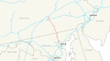
Interstate 83 is an Interstate Highway in the eastern United States
. Its southern terminus is in Baltimore, Maryland at the Fayette Street exit; its northern terminus is in Harrisburg, Pennsylvania
at Interstate 81
.
Most of the route south of Lemoyne, Pennsylvania
is a direct replacement of US 111
, a former spur of US 11
.
|MD
|34.5
|55.5
|-
|PA
|50.8
|81.8
|-
|Total
|85.3
|137.3
|}
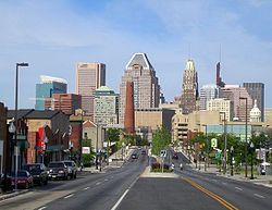
 The Jones Falls Expressway, known to local residents as the JFX, is a 10.2 miles (16.4 km) long freeway that carries Interstate 83 from downtown
Baltimore to the northern suburbs. It is the area's true north–south artery, because Interstate 95 runs mostly east–west through much of the city. Its southern terminus is at Fayette Street, and its northern terminus is at MD 25
, just north of the Baltimore Beltway (I-695). Inside Baltimore, the road is maintained not by the Maryland State Highway Administration
, which controls most freeways in the state, but by the city's Department of Transportation
.
The freeway begins at an at-grade four-way intersection between the Jones Falls Expressway, Fayette Street, and President Street, located in close proximity to the Phoenix Shot Tower
. The latter roadway continues south along the eastern edge of the central business district (CBD) to terminate at a traffic circle near the Inner Harbor
. Fayette Street serves as an access route into the downtown area.
Passing beneath the Orleans Street Viaduct (part of US 40
), the JFX runs north, passing near the Washington Monument
. Between Exits 3 and 4, there is a 90-degree turn that sometimes requires motorists to slow down just before entering it. The curve is located between the Guilford Avenue and Preston Street overpasses. Within the curve, the southbound JFX interchanges with MD 2
.
Having passed this curve, the JFX begins to parallel MD 25
before interchanging with North Avenue (which carries US 1
and US 40 Truck) before continuing north past Druid Lake
, forming the northeastern boundary of Druid Hill Park
. Running northwest out of the city center, the JFX is paralleled by its namesake river, the Jones Falls
, on one side, and the Baltimore Light Rail
system on the other. Closer to downtown, the light rail line peels off in a different direction, while the Falls flows directly underneath the elevated freeway.
After interchanging with Cold Spring Lane and Northern Parkway (between which lies the Cylburn Arboretum
), the JFX exits Baltimore, entering Baltimore County
. Passing close to Mt. Washington Pediatric Hospital
, Mount Saint Agnes College
, and Jones Falls Park, the route skirts the edge of Robert E. Lee Park before interchanging with Ruxton Road just south of the Baltimore Beltway.
At the Beltway, I-83 leaves the JFX and joins I-695
for a distance of 1.4 miles (2.3 km), where it separates from the latter route to continue onward into northern Maryland. Meanwhile, the JFX continues for another 0.5 mile (0.80467 km) in a four-lane divided format before terminating at an at-grade intersection with MD 25
Falls Road. I-83 and I-695 split off at the southern terminus of the Baltimore-Harrisburg Expressway, and I-695 continues its eastward trek towards Towson
and Parkville
.
 After separating from the Beltway, I-83 is now known as the Baltimore-Harrisburg Expressway. Running due north away from the Beltway, the route parallels Maryland Route 45
York Road, the former route of US 111
. Passing to the west of Timonium and Cockeysville
, I-83 leaves the suburban belt around Baltimore and enters rural Baltimore County
just north of Hunt Valley
at Shawan Road. I-83 and MD 45 continue to parallel one another through the northern portion of the county, with MD 45 crossing over I-83 once, at an interchange. This segment of I-83 has several sections with higher than usual gradients.
The only major settlement encountered by I-83 along this stretch is Monkton
, reached via Maryland Route 137
. To the west of I-83, MD 137 connects with the northern terminus of MD 25, I-83's former companion to the south.
The Interstate eventually crosses the Mason-Dixon Line
into York County, Pennsylvania
, 25 miles (40.2 km) north of Baltimore, mere feet from a partial interchange with Freeland Road and parallel with MD 45; the latter route becomes the Susquehanna Trail when it reaches Pennsylvania.
, and runs due north
towards York
. The route bypasses the boroughs of Loganville
and Jacobus
before entering the city of York
.
Uniquely for an Interstate on the east coast, I-83 has a business route through downtown York, known as Interstate 83 Business. The business route follows the former path of US 111
, while I-83 turns northeast and then north again to bypass the urban area. Near PA 462, the Lincoln Highway
, the Interstate turns west for a short distance, then north again to interchange with US 30
. Beyond US 30, I-83 resumes its straight path, running due north out of York and passing to the west of Emigsville
.
North of Pennsylvania Route 295
, I-83 is known as the Susquehanna Expressway. It maintains this name as it passes to the south and west of Valley Green
, continuing north towards Harrisburg
. South of Harrisburg, I-83 interchanges with Interstate 76
, the Pennsylvania Turnpike
. North of I-76, I-83 continues due north, passing through New Cumberland
, before merging with Pennsylvania Route 581 in Lemoyne
.
After merging with PA 581, I-83 is known as the Harrisburg Expressway. The highway turns due east within the merge and crosses the Susquehanna River
over the John Harris Bridge
, south of Harrisburg's central business district
, passing through Paxtang before encountering Interstate 283 and US 322
at the Eisenhower Interchange. Within the interchange, I-83 exits from itself, with each direction of traffic following a one-lane ramp; I-83's former mainline carriageways become US 322, while I-283's former mainline carriageways become I-83. The interchanges includes ramps to local city streets as well. From this point northbound to exit 51 traffic is often congested during daylight hours. I-83 and westbound US 322 continue north toward US 22 and I-81, I-283 goes due south toward the turnpike and PA 283's western terminus, and eastbound US 322 goes due east toward Hershey.
Beyond this interchange, I-83 runs due north again through eastern Harrisburg, interchanging with US 22
northeast of the central business district, before terminating at a three-way semi-directional interchange with Interstate 81
.
being undertaken in September 1982. To compensate for the loss of the remainder of the JFX, the portion in situ was extended to Fayette Street by 1987, and the Jones Falls Boulevard project substantially rebuilt 3/4 of a mile of President Street, across from the JFX at Fayette Street, to allow the traffic to and from the Interstate to be collected and distributed from the surrounding city streets. By 1990, the project was completed.
Due to community opposition to the other freeway plans being produced by city officials, the Jones Falls Expressway was the very first limited-access highway to be completed within the city of Baltimore, and remained so for several years. Originally, the JFX was to continue through the Southeast Baltimore neighborhood of Fells Point to a junction with Interstate 95
, but it was met with the same opposition that killed the extension of Interstate 70 into the city.
, then turn east under the Harbor, pass to the south of Fells Point, return to the surface in the Canton area and continue to I-95.
Under this plan, I-83 was expected to act mostly as a northerly spur to and from the CBD, and as an easterly spur to and from the CBD; through traffic was expected to be a small proportion of the total amount making use of the route. I-83's terminus at I-95 would have been a full 3-way freeway-to-freeway interchange, with a full complement of ramps provided for access to and from Boston Street and O'Donnell Street. When construction began on I-95 through East Baltimore in the mid-1970s, a short six-lane section was built within the vicinity of the planned I-83 interchange. This was done in anticipation of I-83 connecting the CBD to I-95, the rest of which carries at least eight lanes of traffic throughout the city.
 By 1963 the JFX was completed as far south as Guilford Avenue, and by the mid-1970s, was extended to Monument Street. By 1983 the route extended all the way to Pleasant St, with a dead-end bridge stub indicating plans to continue south along the 3-A alignment to I-95.
However, in September 1982 the segment of the JFX between Pleasant Street and I-95, a distance of 4.4 miles (7.1 km), was officially withdrawn from the Interstate Highway System
. Robert Douglas, chief of the Interstate Division for Baltimore City (IDBC), stated at the time that the very high financial costs of the I-83 extension (estimated at $609 million in early 1980s dollars, and likely to reach $1 billion with inflation taken into account) led to the cancellation of the segment. As a result, the JFX was truncated at Fayette Street, ending at an at-grade intersection.
To make up for the loss of the I-83 segment, the Jones Falls Boulevard project substantially rebuilt approximately 1/2 mile of President Street between I-83 and the downtown area to provide the capacity to absorb traffic to and from the Interstate; the project was completed by 1987. Other roadways in the canceled I-83 corridor also benefited from major reconstruction and rehabilitation. The federal funding planned to be used for the I-83 extension was instead cross-transferred to other highway projects; routes that may have benefited include I-97
, I-195
, I-370, and the upgrade of John Hanson Highway
to Interstate 595
.
worked toward reauthorization of the Surface Transportation Act, the Greater Lynchburg Chamber of Commerce and other groups in Virginia wanted Interstate 83 extended southward to provide bypasses for Charlottesville
, Lynchburg
, and Danville
, and to link those cities to Greensboro, North Carolina
. By June 1991, Robert LaLone, director of programs for the Lynchburg Chamber, admitted that an interstate was unlikely, but upgrading of U.S. Highway 29
, with bypasses included, is more likely.
The possibility of extending I-83 north to Rochester, New York instead of I-99 was discussed at the October 2002 I-99 Task Force meeting. However, part of the proposed route on US 11/US 15 has been recently rebuilt as a four lane surface road that does not meet Interstate standards. Expensive additional reconstruction, including new interchanges, service roads and realignments, would be necessary. The farthest north that I-83 could be extended currently would be Benvenue, Pennsylvania on a bridge over the Susquehanna River
, where a recently built freeway section of US 22/US 322 (the Dauphin
Bypass) downgrades to an undivided four-lane road.
In 2005, Walter Sondheim, a prominent Baltimore city planner unveiled a proposal to tear down the elevated portion of the JFX that leads into downtown. In the JFX's place, President Street would be extended north to Eager Street, where the elevated section ends. City officials have since offered tentative support for the idea, though it is unlikely that any action will be taken until about 2020, when the current elevated structure will need an overhaul if it is to remain in use. If the downtown JFX were demolished, Baltimore would join San Francisco
, Boston and Milwaukee
to become among the large American cities that have removed some of their downtown elevated freeways. On May 17, 2009, the Baltimore Sun revealed a plan by Rummel, Klepper & Kahl LLP, to tear down a mile of the Jones Falls Expressway to create an urban boulevard that would help connect downtown to the east side of the city, and Johns Hopkins.
!County
!Location
!Mile
!Exit
!Destinations
!Notes
|-
|rowspan=11 colspan=2|Baltimore
|0.00
|1
|President Street south / Fayette Street
|Southern terminus; at-grade intersection
|-
|0.30
|2
|Pleasant Street
|Southbound exit only
|-
|0.90
|3
|Chase Street
|Northbound exit only
|-
|0.90
|3
|Guilford Avenue
|Southbound exit only
|-
|1.29
|4
|
|Southbound exit only
|-
|1.51
|5
|Maryland Avenue
|Southbound exit, northbound entrance
|-
|1.85
|6
|
|No entrance from southbound US 1 to southbound I-83
|-
|2.42
|7
|28th Street / Druid Lake Park Drive
|Split into exits 7A (Druid Lake Park Drive) and 7B (28th Street) northbound
|-
|3.02
|8
|
|Northbound exit, southbound entrance
|-
|4.74
|9
|Cold Spring Lane
|Split into exits 9A (east) and 9B (west)
|-
|5.86
|10
|Northern Parkway
|Split into exits 10A (east) and 10B (west)
|-
|rowspan=13|Baltimore
|Ruxton
|8.97
|12
|Ruxton Road
|Northbound exit, southbound entrance
|-
|Brooklandville
|9.74
|23
|
|No exit number northbound; signed as I-695 Exit 23 southbound; south end of concurrency with I-695; connector north to MD 25 is unsigned MD 25A
|-
|Lutherville
|11.26
|24
|
|No exit number southbound; signed as I-695 Exit 24 northbound; north end of concurrency with I-695
|-
|rowspan=2|Timonium
|12.59
|16
|Timonium Road
|Split into exits 16A (east) and 16B (west) northbound
|-
|14.02
|17
|Padonia Road
|
|-
|rowspan=2|Cockeysville
|15.44
|18
|Warren Road – Cockeysville
|Northbound exit, southbound entrance; Warren Road is unsigned MD 943
|-
|17.18
|20
|Shawan Road – Cockeysville
|Split into exits 20A (east) and 20B (west)
|-
|Sparks
|20.97
|24
|Belfast Road – Butler
, Sparks
|
|-
|Hereford
|24.26
|27
|
|
|-
|rowspan=2|Parkton
|27.61
|31
|Middletown Road – Parkton
|
|-
|29.63
|33
|
|
|-
|rowspan=2|Maryland Line
|33.22
|36
|
|
|-
|34.35
|37
|Freeland Road
|Southbound exit, northbound entrance
|-
|colspan=2|
|34.50
0.0
|
|colspan=2 align=center|Maryland
–Pennsylvania
state line
|-
|rowspan=21|York
|Shrewsbury Township
|3.5
|4
|
|
|-
|rowspan=2|Springfield Township
|7.5
|8
|
|
|-
|10.4
|10
|
|
|-
|rowspan=4|Spring Garden Township
|13.7
|14
|
|
|-
|14.3
|15
|
|Directional T interchange
|-
|15.5
|16
|
|Split into exits 16A (south) and 16B (north)
|-
|17.6
|18
|
|
|-
|Springettsbury Township
|18.8
|19
|
|Split into exits 19A (east) and 19B (west) southbound
|-
|rowspan=4|Manchester Township
|21.1
|21
|
|Split into exits 21A (east) and 21B (west) northbound; no access from southbound I-83 to westbound US 30 or from eastbound US 30 to northbound I-83
|-
|21.7
|22
|
|
|-
|23.7
|24
|
|
|-
|28.2
|28
|
|
|-
|rowspan=2|Newberry Township
|32.0
|32
|
|
|-
|33.4
|33
|
|
|-
|rowspan=7|Fairview Township
|33.9
|34
|Valley Green
|Northbound exit and entrance
|-
|35.0
|35
|
|
|-
|35.9
|36
|
|
|-
|37.7
|38
|Reesers Summit
|
|-
|38.8
|39A
|
|
|-
|39.1
|39B
|
|I-76 Exit 242 (Harrisburg West)
|-
|39.3
|40A
|Limekiln Road
|
|-
|rowspan=4|Cumberland
|Lower Allen Township
|40.5
|40B
|New Cumberland
|
|-
|rowspan=3|Lemoyne
|41.2
|41A
|
|
|-
|41.4
|41B
|Highland Park
|Northbound exit and entrance north of PA 581; southbound exit and entrance south of PA 581
|-
|41.6
|42
|Lemoyne
|No southbound entrance
|-
|rowspan=11|Dauphin
|rowspan=6|Harrisburg
|42.7
|43
|2nd Street – Capitol
|Directional T interchange
|-
|43.1
|44A
|
|
|-
|43.4
|44B
|17th Street
|Southbound exit and entrance
|-
|43.6
|44B
|19th Street
|Northbound exit and entrance
|-
|44.6
|45
|Paxton Street
|Northbound exit and entrance
|-
|45.3
|45
|Paxton Street
|Southbound exit and entrance
|-
|rowspan=2|Swatara Township
|45.9
|46
|
|Eisenhower Interchange; split into exits 46A (I-283) and 46B (US 322) northbound; no exit 46B southbound
|-
|46.7
|47
|
|Southbound exit and northbound entrance; south end of concurrency with US 322
|-
|rowspan=3|Lower Paxton Township
|47.9
|48
|Union Deposit Road
|
|-
|49.2
|50
|
|Split into exits 50A (east) and 50B (west) northbound
|-
|50.4
|51
|
|Northern terminus; split into exits 51A (south) and 51B (north) northbound; I-81 Exit 70
and PA 283
southeast of Harrisburg
.
business loop in York
, Pennsylvania
. Its northern terminus is at I-83 and Pennsylvania Route 181
north of York. Its southern terminus is at I-83, south of York. The road is known as George Street for much of its length.
I-83 Business is the only business route of I-83 and was the only Interstate business route in the entire state of Pennsylvania, although this changed in 2009 when Pennsylvania Route 60 Business in Moon Township, Pennsylvania
, near Pittsburgh
became signed as Interstate 376 Business when the current alignment of PA 60 itself became an extension of I-376. The route was constructed in 1958 but signed in 1957. I-83 Business goes through downtown York on George Street, the main north–south artery of the city.
United States
The United States of America is a federal constitutional republic comprising fifty states and a federal district...
. Its southern terminus is in Baltimore, Maryland at the Fayette Street exit; its northern terminus is in Harrisburg, Pennsylvania
Harrisburg, Pennsylvania
Harrisburg is the capital of Pennsylvania. As of the 2010 census, the city had a population of 49,528, making it the ninth largest city in Pennsylvania...
at Interstate 81
Interstate 81
Interstate 81 is an Interstate Highway in the eastern part of the United States. Its southern terminus is at Interstate 40 in Dandridge, Tennessee; its northern terminus is on Wellesley Island at the Canadian border, where the Thousand Islands Bridge connects it to Highway 401, the main freeway...
.
Most of the route south of Lemoyne, Pennsylvania
Lemoyne, Pennsylvania
Lemoyne is a borough in Cumberland County, Pennsylvania, United States. Lemoyne was incorporated as a borough on May 23, 1905. As of the 2000 census, the borough population was 3,995. It was formerly named Bridgeport. Lemoyne lies across the Susquehanna River from Harrisburg, Pennsylvania's capital...
is a direct replacement of US 111
U.S. Route 111
U.S. Route 111 was a U.S. Route that ran from Baltimore, Maryland north to the Harrisburg, Pennsylvania area. It replaced part of the Susquehanna Trail and was in turn replaced by Interstate 83. Portions of its pre-freeway alignment are now Maryland Route 45 and Interstate 83 Business...
, a former spur of US 11
U.S. Route 11
U.S. Route 11 is a north–south United States highway extending 1,645 miles across the eastern United States. The southern terminus of the route is at U.S. Route 90 in the Bayou Sauvage National Wildlife Refuge in eastern New Orleans, Louisiana. The northern terminus is at the United...
.
Route description
|-|MD
Maryland
Maryland is a U.S. state located in the Mid Atlantic region of the United States, bordering Virginia, West Virginia, and the District of Columbia to its south and west; Pennsylvania to its north; and Delaware to its east...
|34.5
|55.5
|-
|PA
Pennsylvania
The Commonwealth of Pennsylvania is a U.S. state that is located in the Northeastern and Mid-Atlantic regions of the United States. The state borders Delaware and Maryland to the south, West Virginia to the southwest, Ohio to the west, New York and Ontario, Canada, to the north, and New Jersey to...
|50.8
|81.8
|-
|Total
|85.3
|137.3
|}
Jones Falls Expressway
Downtown Baltimore
Downtown Baltimore is the section of Baltimore traditionally bounded by Martin Luther King, Jr. Boulevard to the west, Mt. Royal Avenue to the north, President Street to the east and the Inner Harbor area to the south. It consists of four neighborhoods: Westside, City Centre, Inner Harbor, and...
Baltimore to the northern suburbs. It is the area's true north–south artery, because Interstate 95 runs mostly east–west through much of the city. Its southern terminus is at Fayette Street, and its northern terminus is at MD 25
Maryland Route 25
Maryland Route 25 , locally known for nearly its entire length as Falls Road, is a state highway in the U.S. state of Maryland. It begins north of downtown Baltimore, just north of Penn Station, and continues north through Baltimore County almost to the Pennsylvania state line...
, just north of the Baltimore Beltway (I-695). Inside Baltimore, the road is maintained not by the Maryland State Highway Administration
Maryland State Highway Administration
The Maryland State Highway Administration is the state agency responsible for maintaining Maryland numbered highways outside of Baltimore City...
, which controls most freeways in the state, but by the city's Department of Transportation
Department of Transportation (Baltimore)
The Baltimore City Department of Transportation maintains the public roadways in the city of Baltimore, Maryland, United States, including street lights, traffic signals, and parking meters...
.
The freeway begins at an at-grade four-way intersection between the Jones Falls Expressway, Fayette Street, and President Street, located in close proximity to the Phoenix Shot Tower
Phoenix Shot Tower
The Phoenix Shot Tower, also known as the Old Baltimore Shot Tower, is a red brick shot tower, tall, located near the downtown and Little Italy areas of Baltimore, Maryland. When it was completed in 1828 it was the tallest structure in the United States...
. The latter roadway continues south along the eastern edge of the central business district (CBD) to terminate at a traffic circle near the Inner Harbor
Inner Harbor
The Inner Harbor is a historic seaport, tourist attraction, and iconic landmark of the City of Baltimore, Maryland, United States. Described by the Urban Land Institute in 2009 as “the model for post-industrial waterfront redevelopment around the World.” The Inner Harbor is actually the end of the...
. Fayette Street serves as an access route into the downtown area.
Passing beneath the Orleans Street Viaduct (part of US 40
U.S. Route 40 in Maryland
U.S. Route 40 in the U.S. state of Maryland runs from western Maryland to Cecil County in the state's northeastern corner. With a total length of over , it is the longest numbered highway in Maryland. Almost half of the road overlaps with Interstate 68 or Interstate 70, while the old alignment...
), the JFX runs north, passing near the Washington Monument
Washington Monument (Baltimore)
The Washington Monument in the elegant Mount Vernon neighborhood of Baltimore, Maryland was the first architectural monument planned to honor George Washington.-History:...
. Between Exits 3 and 4, there is a 90-degree turn that sometimes requires motorists to slow down just before entering it. The curve is located between the Guilford Avenue and Preston Street overpasses. Within the curve, the southbound JFX interchanges with MD 2
Maryland Route 2
Maryland Route 2 is the longest state highway in the U.S. state of Maryland. The route runs from Solomons Island in Calvert County north to an intersection with U.S. Route 1 and U.S. Route 40 Truck in Baltimore...
.
Having passed this curve, the JFX begins to parallel MD 25
Maryland Route 25
Maryland Route 25 , locally known for nearly its entire length as Falls Road, is a state highway in the U.S. state of Maryland. It begins north of downtown Baltimore, just north of Penn Station, and continues north through Baltimore County almost to the Pennsylvania state line...
before interchanging with North Avenue (which carries US 1
U.S. Route 1 in Maryland
U.S. Route 1 is the easternmost and longest of the major north–south routes of the United States Numbered Highway System, running from Key West, Florida to Fort Kent, Maine. In the U.S...
and US 40 Truck) before continuing north past Druid Lake
Druid Lake
Druid Lake is a kettle lake located in the town of Erin, Wisconsin, Washington County, Wisconsinlocated near Hartford, Wisconsin. Druid Lake is a natural glacial-formed lake...
, forming the northeastern boundary of Druid Hill Park
Druid Hill Park
Druid Hill Park is a urban park in northwest Baltimore, Maryland. Its boundaries are marked by Druid Park Drive , Swann Drive and Reisterstown Road , and the Jones Falls Expressway...
. Running northwest out of the city center, the JFX is paralleled by its namesake river, the Jones Falls
Jones Falls
The Jones Falls is a stream in Maryland. It is impounded to create Lake Roland before running through the city of Baltimore and finally emptying into the Baltimore Inner Harbor....
, on one side, and the Baltimore Light Rail
Baltimore Light Rail
The Maryland Transit Administration Light Rail is a light rail system serving Baltimore, Maryland, United States, and the surrounding suburbs.In downtown Baltimore it uses city streets...
system on the other. Closer to downtown, the light rail line peels off in a different direction, while the Falls flows directly underneath the elevated freeway.
After interchanging with Cold Spring Lane and Northern Parkway (between which lies the Cylburn Arboretum
Cylburn Arboretum
Cylburn Arboretum is a city park with arboretum and gardens, located at 4915 Greenspring Avenue, Baltimore, Maryland. It is open daily without charge....
), the JFX exits Baltimore, entering Baltimore County
Baltimore County, Maryland
Baltimore County is a county located in the northern part of the US state of Maryland. In 2010, its population was 805,029. It is part of the Baltimore-Washington Metropolitan Area. Its county seat is Towson. The name of the county was derived from the barony of the Proprietor of the Maryland...
. Passing close to Mt. Washington Pediatric Hospital
Mt. Washington Pediatric Hospital
Mt. Washington Pediatric Hospital is a 70-bed non-profit children's hospital in Baltimore providing long-term care for children with complex health problems, such as obesity, asthma, or skin problems.-History:Mt...
, Mount Saint Agnes College
Mount Saint Agnes College
Mount Saint Agnes College was a Catholic women's college located in the Mount Washington neighborhood of Baltimore, Maryland. It opened in 1890 and was operated by the Sisters of Mercy....
, and Jones Falls Park, the route skirts the edge of Robert E. Lee Park before interchanging with Ruxton Road just south of the Baltimore Beltway.
At the Beltway, I-83 leaves the JFX and joins I-695
Interstate 695 (Maryland)
Interstate 695 is a -long full beltway Interstate Highway extending around Baltimore, Maryland, USA. I-695 is officially designated the McKeldin Beltway, but is colloquially referred to as either the Baltimore Beltway or 695...
for a distance of 1.4 miles (2.3 km), where it separates from the latter route to continue onward into northern Maryland. Meanwhile, the JFX continues for another 0.5 mile (0.80467 km) in a four-lane divided format before terminating at an at-grade intersection with MD 25
Maryland Route 25
Maryland Route 25 , locally known for nearly its entire length as Falls Road, is a state highway in the U.S. state of Maryland. It begins north of downtown Baltimore, just north of Penn Station, and continues north through Baltimore County almost to the Pennsylvania state line...
Falls Road. I-83 and I-695 split off at the southern terminus of the Baltimore-Harrisburg Expressway, and I-695 continues its eastward trek towards Towson
Towson, Maryland
Towson is an unincorporated community and a census-designated place in Baltimore County, Maryland, United States. The population was 55,197 at the 2010 census...
and Parkville
Parkville, Maryland
-Demographics:As of the census of 2000, there were 31,118 people, 13,044 households, and 8,243 families residing in the CDP. The population density was 7,352.1 people per square mile . There were 13,550 housing units at an average density of 3,201.4 per square mile...
.
Baltimore-Harrisburg Expressway
Maryland Route 45
Maryland Route 45 is a state highway in the U.S. state of Maryland. Known for most of its length as York Road, the state highway runs from U.S. Route 1 in Baltimore north to the Pennsylvania state line in Maryland Line, where the highway continues as SR 3001...
York Road, the former route of US 111
U.S. Route 111
U.S. Route 111 was a U.S. Route that ran from Baltimore, Maryland north to the Harrisburg, Pennsylvania area. It replaced part of the Susquehanna Trail and was in turn replaced by Interstate 83. Portions of its pre-freeway alignment are now Maryland Route 45 and Interstate 83 Business...
. Passing to the west of Timonium and Cockeysville
Cockeysville, Maryland
Cockeysville is a census-designated place in Baltimore County, Maryland, United States. The population was 19,388 at the 2000 census.-History:...
, I-83 leaves the suburban belt around Baltimore and enters rural Baltimore County
Baltimore County, Maryland
Baltimore County is a county located in the northern part of the US state of Maryland. In 2010, its population was 805,029. It is part of the Baltimore-Washington Metropolitan Area. Its county seat is Towson. The name of the county was derived from the barony of the Proprietor of the Maryland...
just north of Hunt Valley
Hunt Valley, Maryland
Hunt Valley is an affluent unincorporated community in Baltimore County, Maryland, United States. It lies just north of the city of Baltimore, along Highway 145 off Interstate 83. Loch Raven Reservoir...
at Shawan Road. I-83 and MD 45 continue to parallel one another through the northern portion of the county, with MD 45 crossing over I-83 once, at an interchange. This segment of I-83 has several sections with higher than usual gradients.
The only major settlement encountered by I-83 along this stretch is Monkton
Monkton, Maryland
Monkton is an unincorporated community in northern Baltimore County, Maryland, United States. It has a population of about 4,856 people. It is in area, with approximately...
, reached via Maryland Route 137
Maryland Route 137
Maryland Route 137 is a state highway in the U.S. state of Maryland. MD 137, also known as Mount Carmel Road, is an east–west road which runs from the traffic circle created by Maryland Route 88, commonly known as Black Rock Road in Hampstead, Maryland, and runs through Maryland Route 25,...
. To the west of I-83, MD 137 connects with the northern terminus of MD 25, I-83's former companion to the south.
The Interstate eventually crosses the Mason-Dixon Line
Mason-Dixon line
The Mason–Dixon Line was surveyed between 1763 and 1767 by Charles Mason and Jeremiah Dixon in the resolution of a border dispute between British colonies in Colonial America. It forms a demarcation line among four U.S. states, forming part of the borders of Pennsylvania, Maryland, Delaware, and...
into York County, Pennsylvania
York County, Pennsylvania
York County is a county in the U.S. state of Pennsylvania. As of 2010, the population was 434,972. It is in the Susquehanna Valley, a large fertile agricultural region in South Central Pennsylvania....
, 25 miles (40.2 km) north of Baltimore, mere feet from a partial interchange with Freeland Road and parallel with MD 45; the latter route becomes the Susquehanna Trail when it reaches Pennsylvania.
Pennsylvania
I-83 enters Pennsylvania crossing the Mason-Dixon line and passing to the east of ShrewsburyShrewsbury Township, York County, Pennsylvania
Shrewsbury Township is a township in York County, Pennsylvania, United States. The population was 6,447 at the 2010 census.-Geography:According to the United States Census Bureau, the township has a total area of , of which 0.03% is water...
, and runs due north
towards York
York, Pennsylvania
York, known as the White Rose City , is a city located in York County, Pennsylvania, United States which is in the South Central region of the state. The population within the city limits was 43,718 at the 2010 census, which was a 7.0% increase from the 2000 count of 40,862...
. The route bypasses the boroughs of Loganville
Loganville, Pennsylvania
Loganville, founded in 1820 and named after Colonel Henry Logan, is a borough in York County, Pennsylvania, United States. The population was 1,240 at the 2010 census.-Geography:Loganville is located at ....
and Jacobus
Jacobus, Pennsylvania
Jacobus is a borough in York County, Pennsylvania, United States. The population was 1,841 at the 2010 census.-Geography:Jacobus is located at ....
before entering the city of York
York, Pennsylvania
York, known as the White Rose City , is a city located in York County, Pennsylvania, United States which is in the South Central region of the state. The population within the city limits was 43,718 at the 2010 census, which was a 7.0% increase from the 2000 count of 40,862...
.
Uniquely for an Interstate on the east coast, I-83 has a business route through downtown York, known as Interstate 83 Business. The business route follows the former path of US 111
U.S. Route 111
U.S. Route 111 was a U.S. Route that ran from Baltimore, Maryland north to the Harrisburg, Pennsylvania area. It replaced part of the Susquehanna Trail and was in turn replaced by Interstate 83. Portions of its pre-freeway alignment are now Maryland Route 45 and Interstate 83 Business...
, while I-83 turns northeast and then north again to bypass the urban area. Near PA 462, the Lincoln Highway
Lincoln Highway
The Lincoln Highway was the first road across the United States of America.Conceived and promoted by entrepreneur Carl G. Fisher, the Lincoln Highway spanned coast-to-coast from Times Square in New York City to Lincoln Park in San Francisco, originally through 13 states: New York, New Jersey,...
, the Interstate turns west for a short distance, then north again to interchange with US 30
U.S. Route 30 in Pennsylvania
In the U.S. state of Pennsylvania, U.S. Route 30 runs east–west across the southern part of the state, passing through Pittsburgh and Philadelphia on its way from the West Virginia state line east to the Benjamin Franklin Bridge over the Delaware River into New Jersey...
. Beyond US 30, I-83 resumes its straight path, running due north out of York and passing to the west of Emigsville
Emigsville, Pennsylvania
Emigsville is a census-designated place in York County, Pennsylvania, United States. The population was 2,672 at the 2010 census.-Geography:Emigsville is located in Manchester Township at , just north of the city of York....
.
North of Pennsylvania Route 295
Pennsylvania Route 295
Pennsylvania Route 295 is an long state highway located in York county in Pennsylvania. The southern terminus is at PA 921 near Manchester. The northern terminus is at PA 262 near York Haven.-Route description:...
, I-83 is known as the Susquehanna Expressway. It maintains this name as it passes to the south and west of Valley Green
Valley Green, Pennsylvania
Valley Green is a census-designated place in York County, Pennsylvania, United States. The population was 3,429 at the 2010 census.-Geography:Valley Green is located at in Newberry Township....
, continuing north towards Harrisburg
Harrisburg, Pennsylvania
Harrisburg is the capital of Pennsylvania. As of the 2010 census, the city had a population of 49,528, making it the ninth largest city in Pennsylvania...
. South of Harrisburg, I-83 interchanges with Interstate 76
Interstate 76 (east)
Interstate 76 is an Interstate Highway in the United States, running 435 miles from an interchange with Interstate 71 west of Akron, Ohio, east to Interstate 295 near Camden, New Jersey....
, the Pennsylvania Turnpike
Pennsylvania Turnpike
The Pennsylvania Turnpike is a toll highway system operated by the Pennsylvania Turnpike Commission in the Commonwealth of Pennsylvania, United States. The three sections of the turnpike system total . The main section extends from Ohio to New Jersey and is long...
. North of I-76, I-83 continues due north, passing through New Cumberland
New Cumberland, Pennsylvania
New Cumberland is a municipality at the eastern tip of Cumberland County, Pennsylvania, United States. New Cumberland was incorporated as a borough on March 21, 1831. The population was 7,349 at the 2000 census...
, before merging with Pennsylvania Route 581 in Lemoyne
Lemoyne, Pennsylvania
Lemoyne is a borough in Cumberland County, Pennsylvania, United States. Lemoyne was incorporated as a borough on May 23, 1905. As of the 2000 census, the borough population was 3,995. It was formerly named Bridgeport. Lemoyne lies across the Susquehanna River from Harrisburg, Pennsylvania's capital...
.
After merging with PA 581, I-83 is known as the Harrisburg Expressway. The highway turns due east within the merge and crosses the Susquehanna River
Susquehanna River
The Susquehanna River is a river located in the northeastern United States. At long, it is the longest river on the American east coast that drains into the Atlantic Ocean, and with its watershed it is the 16th largest river in the United States, and the longest river in the continental United...
over the John Harris Bridge
John Harris Bridge
The John Harris Bridge, also known locally as the South Bridge, carries Interstate 83 across the Susquehanna River connecting downtown Harrisburg, Pennsylvania and its western suburbs in Cumberland County, Pennsylvania. The South Bridge officially opened on January 22, 1960 and was later widened...
, south of Harrisburg's central business district
Downtown Harrisburg, Pennsylvania
Downtown Harrisburg, is the central core business and government center which surrounds the focal point of Market Square, and serves a the regional center for the greater metropolitan area of Harrisburg, Pennsylvania, USA....
, passing through Paxtang before encountering Interstate 283 and US 322
U.S. Route 322 in Pennsylvania
U.S. Route 322 is a U.S. highway running from Cleveland, Ohio east to Atlantic City, New Jersey. In the U.S. state of Pennsylvania, the route runs from the Ohio border in West Shenango Township southeast to the Commodore Barry Bridge over the Delaware River in Chester, at which point the route...
at the Eisenhower Interchange. Within the interchange, I-83 exits from itself, with each direction of traffic following a one-lane ramp; I-83's former mainline carriageways become US 322, while I-283's former mainline carriageways become I-83. The interchanges includes ramps to local city streets as well. From this point northbound to exit 51 traffic is often congested during daylight hours. I-83 and westbound US 322 continue north toward US 22 and I-81, I-283 goes due south toward the turnpike and PA 283's western terminus, and eastbound US 322 goes due east toward Hershey.
Beyond this interchange, I-83 runs due north again through eastern Harrisburg, interchanging with US 22
U.S. Route 22 in Pennsylvania
U.S. Route 22 is an east–west route stretching from Cincinnati, Ohio in the west to Newark, New Jersey in the east. In Pennsylvania, the route runs for between the West Virginia state line at Washington County, where it is a limited-access expressway-grade route through the western suburbs...
northeast of the central business district, before terminating at a three-way semi-directional interchange with Interstate 81
Interstate 81 in Pennsylvania
Interstate 81 is an long north–south Interstate Highway, stretching from Dandridge, Tennessee to Fisher's Landing, New York at the US/Canadian border...
.
Jones Falls Expressway
The first Interstate to be built in Baltimore was the Jones Falls Expressway; it was the first to be constructed due to community opposition to the other planned freeways within the city. By the early 1960s, the JFX was completed as far as Guilford Avenue, within the city limits. It was completed as far as Pleasant Street in the downtown area by 1983, with the cancellation of the remaining 4.4 miles (7.1 km) to Interstate 95Interstate 95 in Maryland
Interstate 95 in Maryland is a major highway that runs diagonally from northeast to southwest, from Maryland's border with Delaware, to the Woodrow Wilson Bridge, briefly entering the District of Columbia before reaching Virginia...
being undertaken in September 1982. To compensate for the loss of the remainder of the JFX, the portion in situ was extended to Fayette Street by 1987, and the Jones Falls Boulevard project substantially rebuilt 3/4 of a mile of President Street, across from the JFX at Fayette Street, to allow the traffic to and from the Interstate to be collected and distributed from the surrounding city streets. By 1990, the project was completed.
Due to community opposition to the other freeway plans being produced by city officials, the Jones Falls Expressway was the very first limited-access highway to be completed within the city of Baltimore, and remained so for several years. Originally, the JFX was to continue through the Southeast Baltimore neighborhood of Fells Point to a junction with Interstate 95
Interstate 95 in Maryland
Interstate 95 in Maryland is a major highway that runs diagonally from northeast to southwest, from Maryland's border with Delaware, to the Woodrow Wilson Bridge, briefly entering the District of Columbia before reaching Virginia...
, but it was met with the same opposition that killed the extension of Interstate 70 into the city.
Planning
As part of the planning for an east–west route through Baltimore, the alignment of the JFX underwent various modifications. Under the original plan for freeways in Baltimore, the 1962 Baltimore 10-D Interstate System, the JFX would have junctioned I-70N (which became I-70 in 1975) and I-95, which were planned to follow an east–west route through the southern edge of the CBD, near the southeastern edge of the CBD. The JFX would end at roughly the same location where it currently does. As a result of community opposition to other portions of the 10-D System, the 1969 Baltimore 3-A Interstate and Boulevard System was adopted by the city. In this plan, the JFX would continue south along its present alignment, then turn east and pass through the Fells Point neighborhood on a 6-lane elevated viaduct, before continuing east along Boston Street to junction I-95 (which was also rerouted to its current alignment) north of the Fort McHenry Tunnel. In the mid-1970s, this plan was modified due to fears that the viaduct would result in destruction of the Fells Point area, which contains many historic properties. Under the modification, I-83 would continue south and descend into a 6-lane underwater tunnel beneath the Inner HarborInner Harbor
The Inner Harbor is a historic seaport, tourist attraction, and iconic landmark of the City of Baltimore, Maryland, United States. Described by the Urban Land Institute in 2009 as “the model for post-industrial waterfront redevelopment around the World.” The Inner Harbor is actually the end of the...
, then turn east under the Harbor, pass to the south of Fells Point, return to the surface in the Canton area and continue to I-95.
Under this plan, I-83 was expected to act mostly as a northerly spur to and from the CBD, and as an easterly spur to and from the CBD; through traffic was expected to be a small proportion of the total amount making use of the route. I-83's terminus at I-95 would have been a full 3-way freeway-to-freeway interchange, with a full complement of ramps provided for access to and from Boston Street and O'Donnell Street. When construction began on I-95 through East Baltimore in the mid-1970s, a short six-lane section was built within the vicinity of the planned I-83 interchange. This was done in anticipation of I-83 connecting the CBD to I-95, the rest of which carries at least eight lanes of traffic throughout the city.
Truncation
However, in September 1982 the segment of the JFX between Pleasant Street and I-95, a distance of 4.4 miles (7.1 km), was officially withdrawn from the Interstate Highway System
Interstate Highway System
The Dwight D. Eisenhower National System of Interstate and Defense Highways, , is a network of limited-access roads including freeways, highways, and expressways forming part of the National Highway System of the United States of America...
. Robert Douglas, chief of the Interstate Division for Baltimore City (IDBC), stated at the time that the very high financial costs of the I-83 extension (estimated at $609 million in early 1980s dollars, and likely to reach $1 billion with inflation taken into account) led to the cancellation of the segment. As a result, the JFX was truncated at Fayette Street, ending at an at-grade intersection.
To make up for the loss of the I-83 segment, the Jones Falls Boulevard project substantially rebuilt approximately 1/2 mile of President Street between I-83 and the downtown area to provide the capacity to absorb traffic to and from the Interstate; the project was completed by 1987. Other roadways in the canceled I-83 corridor also benefited from major reconstruction and rehabilitation. The federal funding planned to be used for the I-83 extension was instead cross-transferred to other highway projects; routes that may have benefited include I-97
Interstate 97
Interstate 97 is an intrastate Interstate Highway located entirely within Anne Arundel County, Maryland, United States. It runs from Annapolis at the overlapped section of US 50, US 301, and the unsigned I-595 to Baltimore at the city's beltway...
, I-195
Interstate 195 (Maryland)
Interstate 195 is an Interstate highway in the U.S. state of Maryland. Known as Metropolitan Boulevard, the highway runs from Baltimore/Washington International Thurgood Marshall Airport in Linthicum north to I-95 in Arbutus, where Metropolitan Boulevard continues north as Maryland Route 166 ,...
, I-370, and the upgrade of John Hanson Highway
U.S. Route 50 in Maryland
U.S. Route 50 is a major east–west route of the U.S. Highway system, stretching just over from Ocean City, Maryland on the Atlantic Ocean to West Sacramento, California. In the U.S. state of Maryland, US 50 exists in two sections. The longer of these serves as a major route connecting...
to Interstate 595
Interstate 595 (Maryland)
Interstate 595 is an unsigned number for a section of the John Hanson Highway from Interstate 495 east of Washington, D.C. to Maryland Route 70 at Annapolis, Maryland....
.
Future
As CongressUnited States Congress
The United States Congress is the bicameral legislature of the federal government of the United States, consisting of the Senate and the House of Representatives. The Congress meets in the United States Capitol in Washington, D.C....
worked toward reauthorization of the Surface Transportation Act, the Greater Lynchburg Chamber of Commerce and other groups in Virginia wanted Interstate 83 extended southward to provide bypasses for Charlottesville
Charlottesville, Virginia
Charlottesville is an independent city geographically surrounded by but separate from Albemarle County in the Commonwealth of Virginia, United States, and named after Charlotte of Mecklenburg-Strelitz, the queen consort of King George III of the United Kingdom.The official population estimate for...
, Lynchburg
Lynchburg, Virginia
Lynchburg is an independent city in the Commonwealth of Virginia. The population was 75,568 as of 2010. Located in the foothills of the Blue Ridge Mountains along the banks of the James River, Lynchburg is known as the "City of Seven Hills" or "The Hill City." Lynchburg was the only major city in...
, and Danville
Danville, Virginia
Danville is an independent city in Virginia, United States, bounded by Pittsylvania County, Virginia and Caswell County, North Carolina. It was the last capital of the Confederate States of America. The Bureau of Economic Analysis combines the city of Danville with Pittsylvania county for...
, and to link those cities to Greensboro, North Carolina
Greensboro, North Carolina
Greensboro is a city in the U.S. state of North Carolina. It is the third-largest city by population in North Carolina and the largest city in Guilford County and the surrounding Piedmont Triad metropolitan region. According to the 2010 U.S...
. By June 1991, Robert LaLone, director of programs for the Lynchburg Chamber, admitted that an interstate was unlikely, but upgrading of U.S. Highway 29
U.S. Route 29
U.S. Route 29 is a north–south United States highway that runs for from the western suburbs of Baltimore, Maryland, to Pensacola, Florida. This highway's northern terminus is at Maryland Route 99 in Ellicott City, Maryland...
, with bypasses included, is more likely.
The possibility of extending I-83 north to Rochester, New York instead of I-99 was discussed at the October 2002 I-99 Task Force meeting. However, part of the proposed route on US 11/US 15 has been recently rebuilt as a four lane surface road that does not meet Interstate standards. Expensive additional reconstruction, including new interchanges, service roads and realignments, would be necessary. The farthest north that I-83 could be extended currently would be Benvenue, Pennsylvania on a bridge over the Susquehanna River
Susquehanna River
The Susquehanna River is a river located in the northeastern United States. At long, it is the longest river on the American east coast that drains into the Atlantic Ocean, and with its watershed it is the 16th largest river in the United States, and the longest river in the continental United...
, where a recently built freeway section of US 22/US 322 (the Dauphin
Dauphin, Pennsylvania
Dauphin is a borough in Dauphin County, Pennsylvania, United States. The population was 791 at the 2010 census. Dauphin's ZIP code is 17018. It is part of the Harrisburg–Carlisle Metropolitan Statistical Area.-Geography:Dauphin is located at...
Bypass) downgrades to an undivided four-lane road.
In 2005, Walter Sondheim, a prominent Baltimore city planner unveiled a proposal to tear down the elevated portion of the JFX that leads into downtown. In the JFX's place, President Street would be extended north to Eager Street, where the elevated section ends. City officials have since offered tentative support for the idea, though it is unlikely that any action will be taken until about 2020, when the current elevated structure will need an overhaul if it is to remain in use. If the downtown JFX were demolished, Baltimore would join San Francisco
San Francisco, California
San Francisco , officially the City and County of San Francisco, is the financial, cultural, and transportation center of the San Francisco Bay Area, a region of 7.15 million people which includes San Jose and Oakland...
, Boston and Milwaukee
Milwaukee, Wisconsin
Milwaukee is the largest city in the U.S. state of Wisconsin, the 28th most populous city in the United States and 39th most populous region in the United States. It is the county seat of Milwaukee County and is located on the southwestern shore of Lake Michigan. According to 2010 census data, the...
to become among the large American cities that have removed some of their downtown elevated freeways. On May 17, 2009, the Baltimore Sun revealed a plan by Rummel, Klepper & Kahl LLP, to tear down a mile of the Jones Falls Expressway to create an urban boulevard that would help connect downtown to the east side of the city, and Johns Hopkins.
Exit list
{| class="wikitable"!County
!Location
!Mile
!Exit
Exit number
An exit number is a number assigned to a road junction, usually an exit from a freeway. It is usually marked on the same sign as the destinations of the exit, as well as a sign in the gore....
!Destinations
!Notes
|-
|rowspan=11 colspan=2|Baltimore
|0.00
|1
|President Street south / Fayette Street
|Southern terminus; at-grade intersection
|-
|0.30
|2
|Pleasant Street
|Southbound exit only
|-
|0.90
|3
|Chase Street
|Northbound exit only
|-
|0.90
|3
|Guilford Avenue
|Southbound exit only
|-
|1.29
|4
|
|Southbound exit only
|-
|1.51
|5
|Maryland Avenue
|Southbound exit, northbound entrance
|-
|1.85
|6
|
|No entrance from southbound US 1 to southbound I-83
|-
|2.42
|7
|28th Street / Druid Lake Park Drive
|Split into exits 7A (Druid Lake Park Drive) and 7B (28th Street) northbound
|-
|3.02
|8
|
|Northbound exit, southbound entrance
|-
|4.74
|9
|Cold Spring Lane
|Split into exits 9A (east) and 9B (west)
|-
|5.86
|10
|Northern Parkway
Northern Parkway (Baltimore)
Northern Parkway is a major road that runs west–east across the northern part of the city Baltimore. For most of the way, it is at least six lanes wide, and it is used by motorists for crosstown travel....
|Split into exits 10A (east) and 10B (west)
|-
|rowspan=13|Baltimore
Baltimore County, Maryland
Baltimore County is a county located in the northern part of the US state of Maryland. In 2010, its population was 805,029. It is part of the Baltimore-Washington Metropolitan Area. Its county seat is Towson. The name of the county was derived from the barony of the Proprietor of the Maryland...
|Ruxton
|8.97
|12
|Ruxton Road
|Northbound exit, southbound entrance
|-
|Brooklandville
Brooklandville, Maryland
Brooklandville is an unincorporated community in Baltimore County, Maryland, United States near where the Jones Falls Expressway meets the Baltimore Beltway. The general area is a part of Lutherville, and some addresses in the area are considered to be in Lutherville, though Brooklandville has a...
|9.74
|23
|
|No exit number northbound; signed as I-695 Exit 23 southbound; south end of concurrency with I-695; connector north to MD 25 is unsigned MD 25A
|-
|Lutherville
|11.26
|24
|
|No exit number southbound; signed as I-695 Exit 24 northbound; north end of concurrency with I-695
|-
|rowspan=2|Timonium
|12.59
|16
|Timonium Road
|Split into exits 16A (east) and 16B (west) northbound
|-
|14.02
|17
|Padonia Road
|
|-
|rowspan=2|Cockeysville
Cockeysville, Maryland
Cockeysville is a census-designated place in Baltimore County, Maryland, United States. The population was 19,388 at the 2000 census.-History:...
|15.44
|18
|Warren Road – Cockeysville
Cockeysville, Maryland
Cockeysville is a census-designated place in Baltimore County, Maryland, United States. The population was 19,388 at the 2000 census.-History:...
|Northbound exit, southbound entrance; Warren Road is unsigned MD 943
|-
|17.18
|20
|Shawan Road – Cockeysville
Cockeysville, Maryland
Cockeysville is a census-designated place in Baltimore County, Maryland, United States. The population was 19,388 at the 2000 census.-History:...
|Split into exits 20A (east) and 20B (west)
|-
|Sparks
Sparks, Maryland
Sparks is an unincorporated community that is located in Baltimore County, Maryland, United States. It is situated approximately 20 miles north of Baltimore, Maryland and is considered to be a suburb of the City of Baltimore...
|20.97
|24
|Belfast Road – Butler
Butler, Maryland
Butler is a rural community in Baltimore County, Maryland. It is bordered to the west by Glyndon, east by Sparks, south by Cockeysville, and north by Upperco. It is often referred to as "Worthington Valley". For almost a century it has served as home to many equestrian events including the Grand...
, Sparks
Sparks, Maryland
Sparks is an unincorporated community that is located in Baltimore County, Maryland, United States. It is situated approximately 20 miles north of Baltimore, Maryland and is considered to be a suburb of the City of Baltimore...
|
|-
|Hereford
Hereford, Maryland
Hereford is an unincorporated community in Baltimore County, Maryland, United States....
|24.26
|27
|
|
|-
|rowspan=2|Parkton
Parkton, Maryland
Parkton is a rural area in the northern part of Baltimore County, Maryland, USA. It borders southern York County, PA, and this border forms part of The Mason-Dixon Line...
|27.61
|31
|Middletown Road – Parkton
Parkton, Maryland
Parkton is a rural area in the northern part of Baltimore County, Maryland, USA. It borders southern York County, PA, and this border forms part of The Mason-Dixon Line...
|
|-
|29.63
|33
|
|
|-
|rowspan=2|Maryland Line
Maryland Line, Maryland
Maryland Line is an unincorporated town in Baltimore County, Maryland just south of the Mason-Dixon Line below York County, Pennsylvania after Exit 35. It is accessible from exits 36 and 37 off I-83....
|33.22
|36
|
|
|-
|34.35
|37
|Freeland Road
|Southbound exit, northbound entrance
|-
|colspan=2|
|34.50
0.0
|
|colspan=2 align=center|Maryland
Maryland
Maryland is a U.S. state located in the Mid Atlantic region of the United States, bordering Virginia, West Virginia, and the District of Columbia to its south and west; Pennsylvania to its north; and Delaware to its east...
–Pennsylvania
Pennsylvania
The Commonwealth of Pennsylvania is a U.S. state that is located in the Northeastern and Mid-Atlantic regions of the United States. The state borders Delaware and Maryland to the south, West Virginia to the southwest, Ohio to the west, New York and Ontario, Canada, to the north, and New Jersey to...
state line
|-
|rowspan=21|York
York County, Pennsylvania
York County is a county in the U.S. state of Pennsylvania. As of 2010, the population was 434,972. It is in the Susquehanna Valley, a large fertile agricultural region in South Central Pennsylvania....
|Shrewsbury Township
Shrewsbury Township, York County, Pennsylvania
Shrewsbury Township is a township in York County, Pennsylvania, United States. The population was 6,447 at the 2010 census.-Geography:According to the United States Census Bureau, the township has a total area of , of which 0.03% is water...
|3.5
|4
|
|
|-
|rowspan=2|Springfield Township
Springfield Township, York County, Pennsylvania
Springfield Township is a township in York County, Pennsylvania, United States. The population was 5,152 at the 2010 census.-Geography:According to the United States Census Bureau, the township has a total area of , of which is land and , or 1.17%, is water...
|7.5
|8
|
|
|-
|10.4
|10
|
|
|-
|rowspan=4|Spring Garden Township
|13.7
|14
|
|
|-
|14.3
|15
|
|Directional T interchange
|-
|15.5
|16
|
|Split into exits 16A (south) and 16B (north)
|-
|17.6
|18
|
|
|-
|Springettsbury Township
|18.8
|19
|
|Split into exits 19A (east) and 19B (west) southbound
|-
|rowspan=4|Manchester Township
Manchester Township, York County, Pennsylvania
Manchester Township is a township in York County, Pennsylvania, United States. The population was 18,161 at the 2010 census.-History:Manchester Township, deriving its name from the English Duke of Manchester, was laid out in 1742 by Thomas Cookson, a representative of the Lancaster County Courts,...
|21.1
|21
|
|Split into exits 21A (east) and 21B (west) northbound; no access from southbound I-83 to westbound US 30 or from eastbound US 30 to northbound I-83
|-
|21.7
|22
|
|
|-
|23.7
|24
|
|
|-
|28.2
|28
|
|
|-
|rowspan=2|Newberry Township
|32.0
|32
|
|
|-
|33.4
|33
|
|
|-
|rowspan=7|Fairview Township
Fairview Township, York County, Pennsylvania
Fairview Township is a township in York County, Pennsylvania, United States. The population was 16,668 at the 2010 census.-Geography:According to the United States Census Bureau, the township has a total area of , of which is land and , or 0.17%, is water....
|33.9
|34
|Valley Green
Valley Green, Pennsylvania
Valley Green is a census-designated place in York County, Pennsylvania, United States. The population was 3,429 at the 2010 census.-Geography:Valley Green is located at in Newberry Township....
|Northbound exit and entrance
|-
|35.0
|35
|
|
|-
|35.9
|36
|
|
|-
|37.7
|38
|Reesers Summit
|
|-
|38.8
|39A
|
|
|-
|39.1
|39B
|
|I-76 Exit 242 (Harrisburg West)
|-
|39.3
|40A
|Limekiln Road
|
|-
|rowspan=4|Cumberland
Cumberland County, Pennsylvania
Cumberland County is a county located in the U.S. state of Pennsylvania and is one of three counties comprising the Harrisburg–Carlisle Metropolitan Statistical Area. As of 2010, the population was 235,406.-History:...
|Lower Allen Township
Lower Allen Township, Pennsylvania
Lower Allen Township is a township in Cumberland County, Pennsylvania, United States. The population was 17,437 at the 2000 census.The township has the headquarters of the Pennsylvania Department of Corrections and State Correctional Institution - Camp Hill....
|40.5
|40B
|New Cumberland
New Cumberland, Pennsylvania
New Cumberland is a municipality at the eastern tip of Cumberland County, Pennsylvania, United States. New Cumberland was incorporated as a borough on March 21, 1831. The population was 7,349 at the 2000 census...
|
|-
|rowspan=3|Lemoyne
Lemoyne, Pennsylvania
Lemoyne is a borough in Cumberland County, Pennsylvania, United States. Lemoyne was incorporated as a borough on May 23, 1905. As of the 2000 census, the borough population was 3,995. It was formerly named Bridgeport. Lemoyne lies across the Susquehanna River from Harrisburg, Pennsylvania's capital...
|41.2
|41A
|
|
|-
|41.4
|41B
|Highland Park
Highland Park, Pennsylvania
Highland Park is a census-designated place in Mifflin County, Pennsylvania, United States. The population was 1,446 at the 2000 census.-General information:*ZIP Code: 17044*Area Code: 717*Local Phone Exchanges: 242, 247, 248...
|Northbound exit and entrance north of PA 581; southbound exit and entrance south of PA 581
|-
|41.6
|42
|Lemoyne
Lemoyne, Pennsylvania
Lemoyne is a borough in Cumberland County, Pennsylvania, United States. Lemoyne was incorporated as a borough on May 23, 1905. As of the 2000 census, the borough population was 3,995. It was formerly named Bridgeport. Lemoyne lies across the Susquehanna River from Harrisburg, Pennsylvania's capital...
|No southbound entrance
|-
|rowspan=11|Dauphin
Dauphin County, Pennsylvania
Dauphin County is a county in the U.S. state of Pennsylvania and is one of the three counties comprising the Harrisburg–Carlisle Metropolitan Statistical Area. As of 2010 census, the population was 268,100. The county includes the city of Harrisburg, which has served as the state capital...
|rowspan=6|Harrisburg
Harrisburg, Pennsylvania
Harrisburg is the capital of Pennsylvania. As of the 2010 census, the city had a population of 49,528, making it the ninth largest city in Pennsylvania...
|42.7
|43
|2nd Street – Capitol
|Directional T interchange
|-
|43.1
|44A
|
|
|-
|43.4
|44B
|17th Street
|Southbound exit and entrance
|-
|43.6
|44B
|19th Street
|Northbound exit and entrance
|-
|44.6
|45
|Paxton Street
|Northbound exit and entrance
|-
|45.3
|45
|Paxton Street
|Southbound exit and entrance
|-
|rowspan=2|Swatara Township
Swatara Township, Dauphin County, Pennsylvania
Swatara Township is a township in Dauphin County, Pennsylvania, United States. The population was 22,611 at the 2000 census.-Geography:According to the United States Census Bureau, the township has a total area of 15.8 square miles , of which, 13.2 square miles of it is land and...
|45.9
|46
|
|Eisenhower Interchange; split into exits 46A (I-283) and 46B (US 322) northbound; no exit 46B southbound
|-
|46.7
|47
|
|Southbound exit and northbound entrance; south end of concurrency with US 322
|-
|rowspan=3|Lower Paxton Township
Lower Paxton Township, Pennsylvania
Lower Paxton Township is a township in Dauphin County, Pennsylvania, United States. The township was incorporated in 1767 from Paxton Township...
|47.9
|48
|Union Deposit Road
|
|-
|49.2
|50
|
|Split into exits 50A (east) and 50B (west) northbound
|-
|50.4
|51
|
|Northern terminus; split into exits 51A (south) and 51B (north) northbound; I-81 Exit 70
Auxiliary routes
I-83 has only one spur route: Interstate 283, a connector to Interstate 76Interstate 76 (east)
Interstate 76 is an Interstate Highway in the United States, running 435 miles from an interchange with Interstate 71 west of Akron, Ohio, east to Interstate 295 near Camden, New Jersey....
and PA 283
Pennsylvania Route 283
Pennsylvania Route 283 is a long state highway in the U.S. state of Pennsylvania. It connects Harrisburg to Lancaster as a freeway, paralleling the old U.S. Route 230...
southeast of Harrisburg
Harrisburg, Pennsylvania
Harrisburg is the capital of Pennsylvania. As of the 2010 census, the city had a population of 49,528, making it the ninth largest city in Pennsylvania...
.
Business loop of York, Pennsylvania
Interstate 83 Business is a short InterstateInterstate Highway System
The Dwight D. Eisenhower National System of Interstate and Defense Highways, , is a network of limited-access roads including freeways, highways, and expressways forming part of the National Highway System of the United States of America...
business loop in York
York, Pennsylvania
York, known as the White Rose City , is a city located in York County, Pennsylvania, United States which is in the South Central region of the state. The population within the city limits was 43,718 at the 2010 census, which was a 7.0% increase from the 2000 count of 40,862...
, Pennsylvania
Pennsylvania
The Commonwealth of Pennsylvania is a U.S. state that is located in the Northeastern and Mid-Atlantic regions of the United States. The state borders Delaware and Maryland to the south, West Virginia to the southwest, Ohio to the west, New York and Ontario, Canada, to the north, and New Jersey to...
. Its northern terminus is at I-83 and Pennsylvania Route 181
Pennsylvania Route 181
Pennsylvania Route 181 is a long north–south state route in south central Pennsylvania. Its northern terminus is at Pennsylvania Route 382 in York Haven. Its southern terminus is at I-83 Business and U.S...
north of York. Its southern terminus is at I-83, south of York. The road is known as George Street for much of its length.
I-83 Business is the only business route of I-83 and was the only Interstate business route in the entire state of Pennsylvania, although this changed in 2009 when Pennsylvania Route 60 Business in Moon Township, Pennsylvania
Moon Township, Pennsylvania
Moon Township is a township along the Ohio River in Allegheny County, Pennsylvania, United States. Moon is a part of the Pittsburgh Metro Area and is located northwest of Pittsburgh. The origin of its name is unknown for certain, although it has been suggested that it derives from a...
, near Pittsburgh
Pittsburgh, Pennsylvania
Pittsburgh is the second-largest city in the US Commonwealth of Pennsylvania and the county seat of Allegheny County. Regionally, it anchors the largest urban area of Appalachia and the Ohio River Valley, and nationally, it is the 22nd-largest urban area in the United States...
became signed as Interstate 376 Business when the current alignment of PA 60 itself became an extension of I-376. The route was constructed in 1958 but signed in 1957. I-83 Business goes through downtown York on George Street, the main north–south artery of the city.
External links
- AARoads.com article on I-83
- I-83 @ MDRoads.com
- Interstate Guide - I-83
- Maryland Multiplexes - I-83/I-695 Duplex
- Pennsylvania Multiplexes - I-83/US 322 Duplex
- Steve Anderson's DCroads.net: Baltimore-Harrisburg Expressway (I-83)
- Steve Anderson's DCroads.net: Jones Falls Expressway (I-83)
- Roads to the Future: Baltimore Harbor Interstate Map
- Kelly, Jacques. "JFX is a long stretch of history," The Baltimore Sun, Saturday, February 7, 2009.