
Springfield Interchange
Encyclopedia
The Springfield Interchange, also known as the Mixing Bowl, is the interchange of Interstate 95
, Interstate 395, and Interstate 495
in Springfield
, Virginia
, outside of Washington, D.C.
. The interchange is located at exit 57 on the Capital Beltway
and exit 170 on I-95
.
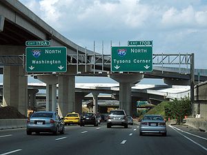
This interchange is nicknamed the "Mixing Bowl" because, prior to the reconstruction, local and long distance travelers shared the same lanes and travelers had to merge to the right or left to reach the correct lanes for their destination. The last of this weaving and merging was eliminated on April 21, 2007. The interchange is one of the busiest highway junctions in the U.S., serving about 430,000 cars per day.
prevented its construction through the city, I-95 was shifted to the eastern portion of the Beltway, between Springfield and College Park, Maryland
. Because of this route change, all traffic continuing on I-95 through the Washington area was exiting at Springfield through an interchange not designed for that purpose. By early 1970, there were 150,000 vehicles per day traveling through the intersection. Thirty years later, that number had more than doubled, with the effect that vehicles "traveling along the East Coast's main north–south artery [had to] be funneled through the ordinary exit ramps at Springfield, routinely causing backups several miles long."
A study by the National Highway Traffic Safety Administration determined the interchange to be the site of 179 crashes between 1993 and 1994—more than any other spot on I-95—and found that the number of ramp accidents was more than double that of any other Beltway interchange.
(VDOT) began an eight-year, seven-phase reconstruction project, which also involved the reconstruction of the I-95/Route 644
interchange. The project was one of the largest highway construction projects in the U.S., costing $676 million.
Upon completion, The Washington Post noted: "The project began in 1994 with a budget of $241 million. By 2002, it had nearly tripled, to $676 million, and a federal audit found that VDOT had underestimated costs and mismanaged funds. As recently as [2005], the project was months behind schedule, and managers predicted that it would not be completed on time. But VDOT officials pressured the primary contractor, including issuing a formal default letter, and work was put back on schedule without adding costs."
The project was completed on time in July 2007. The new interchange has 50 ramps and bridges, is 24 lanes at its widest point, and has a capacity of 500,000 vehicles per day.
Phase 8 of the Springfield Interchange is currently under construction as part of the I-495 HOT lanes project, based on an infusion of $400 million of VDOT cash into the project, which will also include interchange construction near Tysons Corner (connectors to Jones Branch and Westpark Drives) and improvements at the Interstate 66
and Dulles Toll Road interchanges.
.
and Arlington National Cemetery
; this interchange, like the Springfield one, contains a large number of lanes and ramps. However, most news reports on the Springfield Interchange refer to it as the "Mixing Bowl", and the term has become generally accepted. The other interchange is now known as the Pentagon road network
.
Interstate 95 in Virginia
In the Commonwealth of Virginia, Interstate 95 runs through the state. It runs concurrently for with Interstate 64 in Richmond, and meets the northern terminus of Interstate 85 in Petersburg. Though Interstate 95 was originally planned to go straight through Washington, D.C., it was instead...
, Interstate 395, and Interstate 495
Interstate 495 (Capital Beltway)
Interstate 495 is a Interstate Highway that surrounds the United States' capital of Washington, D.C., and its inner suburbs in adjacent Maryland and Virginia. I-495 is widely known as the Capital Beltway or simply the Beltway, especially when the context of Washington, D.C., is clear...
in Springfield
Springfield, Virginia
Springfield is a census-designated place in Fairfax County, Virginia, United States and a suburb of Washington, D.C. The Springfield CDP is recognized by the U.S. Census Bureau with a population of 30,484 as of the 2010 census. Homes and businesses in bordering CDPs including North Springfield,...
, Virginia
Virginia
The Commonwealth of Virginia , is a U.S. state on the Atlantic Coast of the Southern United States. Virginia is nicknamed the "Old Dominion" and sometimes the "Mother of Presidents" after the eight U.S. presidents born there...
, outside of Washington, D.C.
Washington, D.C.
Washington, D.C., formally the District of Columbia and commonly referred to as Washington, "the District", or simply D.C., is the capital of the United States. On July 16, 1790, the United States Congress approved the creation of a permanent national capital as permitted by the U.S. Constitution....
. The interchange is located at exit 57 on the Capital Beltway
Interstate 495 (Capital Beltway)
Interstate 495 is a Interstate Highway that surrounds the United States' capital of Washington, D.C., and its inner suburbs in adjacent Maryland and Virginia. I-495 is widely known as the Capital Beltway or simply the Beltway, especially when the context of Washington, D.C., is clear...
and exit 170 on I-95
Interstate 95 in Virginia
In the Commonwealth of Virginia, Interstate 95 runs through the state. It runs concurrently for with Interstate 64 in Richmond, and meets the northern terminus of Interstate 85 in Petersburg. Though Interstate 95 was originally planned to go straight through Washington, D.C., it was instead...
.
This interchange is nicknamed the "Mixing Bowl" because, prior to the reconstruction, local and long distance travelers shared the same lanes and travelers had to merge to the right or left to reach the correct lanes for their destination. The last of this weaving and merging was eliminated on April 21, 2007. The interchange is one of the busiest highway junctions in the U.S., serving about 430,000 cars per day.
History
The interchange was originally built in the 1960s as a simple interchange between I-95 and the Capital Beltway. At the time, I-95 was expected to go through the District of Columbia. After community oppositionFreeway and expressway revolts
Many freeway revolts took place in developed countries during the 1960s and 1970s, in response to plans for the construction of new freeways, a significant number of which were abandoned or significantly scaled back due to widespread public opposition; especially of those whose neighborhoods would...
prevented its construction through the city, I-95 was shifted to the eastern portion of the Beltway, between Springfield and College Park, Maryland
College Park, Maryland
College Park is a city in Prince George's County, Maryland, USA. The population was 30,413 at the 2010 census. It is best known as the home of the University of Maryland, College Park, and since 1994 the city has also been home to the "Archives II" facility of the U.S...
. Because of this route change, all traffic continuing on I-95 through the Washington area was exiting at Springfield through an interchange not designed for that purpose. By early 1970, there were 150,000 vehicles per day traveling through the intersection. Thirty years later, that number had more than doubled, with the effect that vehicles "traveling along the East Coast's main north–south artery [had to] be funneled through the ordinary exit ramps at Springfield, routinely causing backups several miles long."
A study by the National Highway Traffic Safety Administration determined the interchange to be the site of 179 crashes between 1993 and 1994—more than any other spot on I-95—and found that the number of ramp accidents was more than double that of any other Beltway interchange.
Major reconstruction (1999–2007)
In March 1999, the Virginia Department of TransportationVirginia Department of Transportation
The Virginia Department of Transportation is the agency of state government responsible for transportation in the state of Virginia in the United States. Headquartered in Downtown Richmond, VDOT is responsible for building, maintaining, and operating the roads, bridges and tunnels in the...
(VDOT) began an eight-year, seven-phase reconstruction project, which also involved the reconstruction of the I-95/Route 644
Virginia State Route 644 (Fairfax County)
State Route 644 is a secondary state highway in southern Fairfax County, Virginia. It is the closest main east–west road that is south of the Beltway. It is known primarily as Franconia Road east of I-95, and Old Keene Mill Rd west of I-95...
interchange. The project was one of the largest highway construction projects in the U.S., costing $676 million.
Phases 2 and 3
Completed November 2001- Reconstruct the I-95/Route 644 interchange.
- Make the I-95 Northbound entry ramp from eastbound Route 644 enter on the right.
- Reconstruct the Commerce Street bridge.
- Improve the Amherst Street bridge.
- Construct a flyover from westbound Route 644 onto I-95 south and therefore demolish the original cloverleaf that served this purpose
- Add an express bridge for Route 644
- Make the I-95 North ramp onto Exit 169 separate from I-95
- Add a cloverleaf ramp from I-95 North onto Route 644 westbound
- Construct a bridge from eastbound Route 644 onto the I-95 HOV Lanes (northbound only).
- Reconstruct the I-95 HOV Lane ramp (southbound only) onto Route 644 westbound.
Phase 4
Completed October 2004- Relocate the Outer Loop, eastbound I-495, of Interstate 495 where it crosses I-395, this time making it a higher bridge.
- Add a two-lane flyover bridge from I-495 West/I-95 South/Capital Beltway Inner Loop, back to I-95 South (even this bridge is sometimes congested during afternoon hours).
Phase 5
Completed May 2004- Reconstruct the ramp from I-395 Southbound onto I-495 North/Capital Beltway Inner Loop
- Widen a small portion of the Capital Beltway northwest of I-395
Phases 6 and 7
Completed July 2007- Construct a one-lane flyover connecting I-395 South onto I-95 North/I-495 Outer Loop, opened on October 2, 2005.
- Construct a flyover connecting I-395 South and I-495 Outer Loop onto the Route 644 exit, opened on October 5, 2005, but not all of the lanes are open (see below).
- Construct a two-lane flyover for I-95 North express travelers onto I-495 Outer Loop, opened on January 19, 2006.
- Construct a three-lane flyover connecting I-95 North onto I-495 Inner Loop and therefore demolish the old cloverleaf ramp serving this purpose, opened on August 24, 2006. Note that demolition of the old ramp is currently taking place.
- Construct a new two-lane bridge, exiting the Beltway from the right lane as opposed to the old ramp that exited on the left, connecting I-495 Outer Loop with I-395 North, opened on March 15, 2007. See New Beltway Outer Loop Ramp to I-395 North Opens Thursday Morning.
- Separate travelers heading onto I-395 North/I-495/I-95 North from Route 644 westbound by giving them their own lanes and reconstructing the original ramp connecting I-95 North with the Outer Loop. The new ramp allowing these maneuvers opened on April 21, 2007. The ramp to I-395 now joins the main northbound lanes to the north of the previous merge after passing under the Outer Loop; the advantage of this design is that it eliminates the need for traffic taking this route to merge left onto I-395 at the same spot where traffic exiting I-95 onto the flyover ramp to the Inner Loop is required to move right. On the same date that this new ramp opened, the northbound lanes of I-395 were shifted slightly to the right (east) onto a new overpass over the Inner Loop, eliminating a sharp left-right movement over a potholed stretch of pavement that had existed for several years during the construction.
- Separate travelers from I-495 and I-395 South heading onto Route 644 by giving their own lanes, completed in mid-2007. The two-lane ramp from the Outer Loop (I-495 East) to I-95 South opened on December 15, 2006. Workers planned to open the ramp on December 6, but between December 6 and 15, the 5:00-9:00 temperature was below 45°F (about 7°C), preventing the lane markings from sticking. The original ramp from the Outer Loop to I-95 South was temporarily closed when this new ramp opened to allow for sound wall work. The old ramp reopened in late May 2007 and is signed to carry traffic from the Outer Loop to westbound Route 644 (Old Keene Mill Road). Signs direct Outer Loop traffic heading to eastbound Route 644 (Franconia Road) to use the new ramp opened in 2006. The remaining lanes on the ramps to Route 644 from the Inner Loop and from southbound I-395 opened at the same time as the reopening of the original Outer Loop ramp (now signed as Exit 169B). Contrary to original indications, no barrier separates westbound and eastbound traffic; rather, the design is intended to eliminate the need for drivers to change lanes to reach the proper ramps for their destination.
Upon completion, The Washington Post noted: "The project began in 1994 with a budget of $241 million. By 2002, it had nearly tripled, to $676 million, and a federal audit found that VDOT had underestimated costs and mismanaged funds. As recently as [2005], the project was months behind schedule, and managers predicted that it would not be completed on time. But VDOT officials pressured the primary contractor, including issuing a formal default letter, and work was put back on schedule without adding costs."
The project was completed on time in July 2007. The new interchange has 50 ramps and bridges, is 24 lanes at its widest point, and has a capacity of 500,000 vehicles per day.
Phase 8
This phase was originally planned to be part of the Springfield Interchange Project but due to cost overruns was moved to the future Capital Beltway widening project, which was to include HOV Lanes on the Capital Beltway. However, due in part to both a lack of funds for the Capital Beltway widening project and public outrage at its plan to remove hundreds of homes as part of the project, VDOT has entered into an agreement with Fluor Enterprises, Inc.—under the Public-Private Transportation Act of 1995—to instead build HOT lanes where the collected tolls would offset construction costs. VDOT originally did not require Fluor to complete Phase 8, and it is not in Fluor's 2003 proposal to do so.Phase 8 of the Springfield Interchange is currently under construction as part of the I-495 HOT lanes project, based on an infusion of $400 million of VDOT cash into the project, which will also include interchange construction near Tysons Corner (connectors to Jones Branch and Westpark Drives) and improvements at the Interstate 66
Interstate 66
Interstate 66 is an Interstate Highway in the eastern United States. As indicated by its even route number, it runs in an east–west direction. Its western terminus is at Middletown, Virginia, at an intersection with Interstate 81; its eastern terminus is in Washington, D.C., at an...
and Dulles Toll Road interchanges.
Other improvements
To aid commuters during construction, VDOT added 5,000 park-and-ride spaces, created a vanpool program, increased safety patrols to clear breakdowns, created a project web site, and distributed notifications of lane closures via an email list. VDOT also maintained a storefront office in the Springfield MallSpringfield Mall (Virginia)
Springfield Mall is an enclosed shopping mall in Springfield, Virginia, located at the intersection of Interstate 95 and Franconia Road which is part of the Springfield Interchange. The mall is also located 1/4 mile north of Franconia-Springfield Parkway and the Franconia-Springfield metro station...
.
Earlier uses of the "Mixing Bowl" name
The term "Mixing Bowl" was previously used to refer to the interchange between I-395 and State Route 27 in Arlington, near the PentagonThe Pentagon
The Pentagon is the headquarters of the United States Department of Defense, located in Arlington County, Virginia. As a symbol of the U.S. military, "the Pentagon" is often used metonymically to refer to the Department of Defense rather than the building itself.Designed by the American architect...
and Arlington National Cemetery
Arlington National Cemetery
Arlington National Cemetery in Arlington County, Virginia, is a military cemetery in the United States of America, established during the American Civil War on the grounds of Arlington House, formerly the estate of the family of Confederate general Robert E. Lee's wife Mary Anna Lee, a great...
; this interchange, like the Springfield one, contains a large number of lanes and ramps. However, most news reports on the Springfield Interchange refer to it as the "Mixing Bowl", and the term has become generally accepted. The other interchange is now known as the Pentagon road network
Pentagon road network
The Pentagon road network is a system of highways, mostly freeways, built by the United States federal government in the early 1940s to serve the Pentagon in northern Virginia. The roads, transferred to the Commonwealth of Virginia in 1964, are now state highways...
.
External links
- The official VDOT website (you must have Macromedia Flash in order to view this page properly)
- Springfield Interchange Project, Roads to the Future, Highway and Transportation History