

Hurricane preparedness for New Orleans
Encyclopedia

New Orleans
New Orleans, Louisiana
New Orleans is a major United States port and the largest city and metropolitan area in the state of Louisiana. The New Orleans metropolitan area has a population of 1,235,650 as of 2009, the 46th largest in the USA. The New Orleans – Metairie – Bogalusa combined statistical area has a population...
was built on a delta
River delta
A delta is a landform that is formed at the mouth of a river where that river flows into an ocean, sea, estuary, lake, reservoir, flat arid area, or another river. Deltas are formed from the deposition of the sediment carried by the river as the flow leaves the mouth of the river...
marsh
Marsh
In geography, a marsh, or morass, is a type of wetland that is subject to frequent or continuous flood. Typically the water is shallow and features grasses, rushes, reeds, typhas, sedges, other herbaceous plants, and moss....
. Unlike the first two centuries of its existence, today, a little less than half of the modern city sits below sea level. The city is surrounded by the Mississippi River
Mississippi River
The Mississippi River is the largest river system in North America. Flowing entirely in the United States, this river rises in western Minnesota and meanders slowly southwards for to the Mississippi River Delta at the Gulf of Mexico. With its many tributaries, the Mississippi's watershed drains...
to the south, Lake Pontchartrain
Lake Pontchartrain
Lake Pontchartrain is a brackish estuary located in southeastern Louisiana. It is the second-largest inland saltwater body of water in the United States, after the Great Salt Lake in Utah, and the largest lake in Louisiana. As an estuary, Pontchartrain is not a true lake.It covers an area of with...
to the north, and Lake Borgne
Lake Borgne
Lake Borgne is a lagoon in eastern Louisiana of the Gulf of Mexico. Due to coastal erosion, it is no longer actually a lake but rather an arm of the Gulf of Mexico. Its name comes from the French word borgne, which means "one-eyed".-Geography:...
to the east.
The parts of New Orleans and the surrounding communities first settled in the colonial era through the 19th century were and still are above sea level. However flooding was long a threat, from the periodic high waters of the Mississippi and more occasional severe storms which would push the waters of Lake Pontchartrain into settled areas. Construction of the levee
Levee
A levee, levée, dike , embankment, floodbank or stopbank is an elongated naturally occurring ridge or artificially constructed fill or wall, which regulates water levels...
s along the River began soon after the city was founded, and more extensive river levees were built as the city grew. These earthen barriers were originally erected to prevent damage caused by seasonal flooding. On the lakeside, much of the land was undeveloped swamp
Swamp
A swamp is a wetland with some flooding of large areas of land by shallow bodies of water. A swamp generally has a large number of hammocks, or dry-land protrusions, covered by aquatic vegetation, or vegetation that tolerates periodical inundation. The two main types of swamp are "true" or swamp...
and only small levees were constructed in the 19th century.
Colonial era
Awareness of the city's vulnerability to hurricanes dates back to the early Colonial era. A major hurricane hit the city in September of 1722, leveling many of the buildings in the young city.1794 was perhaps as dreadful a year as the city of New Orleans ever experienced, as it was hit by two hurricanes in addition to a major fire.
19th century hurricanes
The 19th century saw such hurricanes as the 1856 Last Island Hurricane1856 Last Island Hurricane
The Last Island hurricane of 1856 was an intense Atlantic hurricane that destroyed Last Island in southern Louisiana. The first tropical cyclone, first hurricane, and first major hurricane of the season, it rapidly intensified before making landfall as a Category 4 hurricane. The powerful...
and the 1893 Chenier Caminanda Hurricane
1893 Chenier Caminanda Hurricane
The Chenière Caminada Hurricane, also known as the Great October Storm, was a powerful hurricane that devastated the island of Chenière Caminada, Louisiana in early October 1893...
.
Early 20th century hurricanes
1909 saw the Grand Isle Hurricane of 1909 hit the city. There was major flooding of "back of town" area and the undeveloped swamps north of town.1915: The New Orleans Hurricane of 1915
New Orleans Hurricane of 1915
The New Orleans Hurricane of 1915 was an intense Category 4 hurricane that made landfall near Grand Isle, Louisiana during the 1915 Atlantic hurricane season. The hurricane killed 275 people and caused $13 million in damage....
or as it was commonly called locally "The Great Storm of 1915" struck with more wind damage than the 1909 storm. Flooding was more limited in scope and duration due to improved drainage pumping. However Lake Pontchartrain rose to a higher level than previously recorded, overtopping some of the back levees. The Sewage and Water Board recommended higher levees to protect the city from flooding on the Lake side.
A much larger project to build up levees along the lake and extend the shoreline out by dredging began in 1927. As the city grew, there was increased pressure to develop lower areas. A large system of canals and pumps was constructed to drain the city. Flooding containment efforts until the mid-20th century primarily focused on floods from the Mississippi River
Mississippi River
The Mississippi River is the largest river system in North America. Flowing entirely in the United States, this river rises in western Minnesota and meanders slowly southwards for to the Mississippi River Delta at the Gulf of Mexico. With its many tributaries, the Mississippi's watershed drains...
.
The 1947 Fort Lauderdale Hurricane
1947 Fort Lauderdale Hurricane
The Fort Lauderdale Hurricane was an intense Category 5 hurricane that affected the Bahamas, Florida, Louisiana, and Mississippi in September of the 1947 Atlantic hurricane season...
hit the New Orleans area. The metro area suffered moderate hurricane wind damage. Flood prevention was largely successful in the city, but there was severe flooding in the new East Jefferson suburbs.
Late 20th century hurricanes

Hurricane Flossy (1956)
Hurricane Flossy originated from a tropical disturbance in the eastern Pacific Ocean and moved across Central America into the Gulf of Mexico as a tropical depression on September 21, which became a tropical storm on September 22 and a hurricane on September 23...
in 1956 resulted in flooding in parts of Eastern New Orleans
Eastern New Orleans
Eastern New Orleans is a large section of the city of New Orleans, Louisiana. Developed extensively from the 1960s onwards, it was originally marketed as "suburban-style living within the city limits", and has much in common with the Algiers neighborhood of New Orleans...
.
Hurricane Betsy
Hurricane Betsy
Hurricane Betsy was a Category 4 hurricane of the 1965 Atlantic hurricane season which caused enormous damage in the Bahamas, Florida, and Louisiana. Betsy made its most intense landfall near the mouth of the Mississippi River, causing significant flooding of the waters of Lake Pontchartrain into...
in 1965 alerted a new generation to the threat of major hurricane hits. As radar showed the storm heading for the city, a mandatory evacuation of Eastern New Orleans
Eastern New Orleans
Eastern New Orleans is a large section of the city of New Orleans, Louisiana. Developed extensively from the 1960s onwards, it was originally marketed as "suburban-style living within the city limits", and has much in common with the Algiers neighborhood of New Orleans...
was declared. The Mississippi River-Gulf Outlet Canal
Mississippi River-Gulf Outlet Canal
The Mississippi River – Gulf Outlet Canal is a channel constructed by the United States Army Corps of Engineers in the mid-20th century that provided a shorter route between the Gulf of Mexico and New Orleans' inner harbor Industrial Canal via the Intracoastal Waterway...
channeled storm surge
Storm surge
A storm surge is an offshore rise of water associated with a low pressure weather system, typically tropical cyclones and strong extratropical cyclones. Storm surges are caused primarily by high winds pushing on the ocean's surface. The wind causes the water to pile up higher than the ordinary sea...
into the metro area. A levee failure was responsible for major flooding in Lower 9th Ward.
The heavy flooding caused by Hurricane Betsy brought concerns regarding flooding from hurricanes to the forefront. Betsy resulted in major redesign of levee system. By authorizing
Flood Control Act of 1965
The Flood Control Act of 1965, Title II of , was enacted on October 27, 1965, by the 89th Congress and authorized the United States Army Corps of Engineers to design and construct numerous flood control projects including the Lake Pontchartrain and Vicinity, Louisiana Hurricane Protection Project...
the United States Army Corps of Engineers
United States Army Corps of Engineers
The United States Army Corps of Engineers is a federal agency and a major Army command made up of some 38,000 civilian and military personnel, making it the world's largest public engineering, design and construction management agency...
to design and construct the flood protection, Congress essentially overrode responsibility for the local flood protection by the local levee boards. The Flood Control Act of 1965
Flood Control Act of 1965
The Flood Control Act of 1965, Title II of , was enacted on October 27, 1965, by the 89th Congress and authorized the United States Army Corps of Engineers to design and construct numerous flood control projects including the Lake Pontchartrain and Vicinity, Louisiana Hurricane Protection Project...
directed the Corps of Engineers to design and construct the flood protection for the maximum anticipated hurricane for the area. (This project was still under construction when the city was hit by Katrina 40 years later.)
The Corps of Engineers also designed a Lake Pontchartrain Hurricane Barrier to shield the city with flood gates like those that protect the Netherlands
Netherlands
The Netherlands is a constituent country of the Kingdom of the Netherlands, located mainly in North-West Europe and with several islands in the Caribbean. Mainland Netherlands borders the North Sea to the north and west, Belgium to the south, and Germany to the east, and shares maritime borders...
from the North Sea
North Sea
In the southwest, beyond the Straits of Dover, the North Sea becomes the English Channel connecting to the Atlantic Ocean. In the east, it connects to the Baltic Sea via the Skagerrak and Kattegat, narrow straits that separate Denmark from Norway and Sweden respectively...
. Congress provided funding and construction began in 1971, but work stopped in 1977 when a federal judge ruled, in a suit brought by the environmental group Save Our Wetlands, that the Corps' environmental impact statement
Environmental impact statement
An environmental impact statement , under United States environmental law, is a document required by the National Environmental Policy Act for certain actions "significantly affecting the quality of the human environment". An EIS is a tool for decision making...
was deficient. In 1985, after nearly a decade of court battles, the Corps scrapped the plan, and decided on reinforcing the city’s levee system instead.
The threat of Hurricane Camille
Hurricane Camille
Hurricane Camille was the third and strongest tropical cyclone and second hurricane during the 1969 Atlantic hurricane season. The second of three catastrophic Category 5 hurricanes to make landfall in the United States during the 20th century , which it did near the mouth of the Mississippi River...
was shown in advance by improvement in radar technology, and much of New Orleans braced for a repeat of Betsy. However instead Camille turned east to hit the Mississippi Gulf Coast.
Hurricane Juan (1985)
Hurricane Juan (1985)
Hurricane Juan was a hurricane that formed in October 1985 and looped twice near the Louisiana coast, causing torrential flooding for several days. Juan was the costliest hurricane of the 1985 Atlantic hurricane season, and at the time was among the costliest of all historical U.S. hurricanes...
prompted a large evacuation from the city, but did little damage.
Hurricane Andrew
Hurricane Andrew
Hurricane Andrew was the third Category 5 hurricane to make landfall in the United States, after the Labor Day Hurricane of 1935 and Hurricane Camille in 1969. Andrew was the first named storm and only major hurricane of the otherwise inactive 1992 Atlantic hurricane season...
threatened the city in 1992. Clearly a major killer storm that had already devastated parts of South Florida, it prompted the largest evacuation of the city to date. The storm turned west of the city, but prompted re-evaluation of emergency evacuation plans.
Hurricane Georges
Hurricane Georges
Hurricane Georges was a very destructive, powerful and long-lived Cape Verde-type Category 4 hurricane. Georges was the seventh tropical storm, fourth hurricane, and second major hurricane of the 1998 Atlantic hurricane season...
in 1998 prompted an even larger evacuation. The Louisiana Superdome
Louisiana Superdome
The Mercedes-Benz Superdome, previously known as the Louisiana Superdome and colloquially known as the Superdome, is a sports and exhibition arena located in the Central Business District of New Orleans, Louisiana, USA...
was opened as a shelter of last resort for those unable to evacuate, with unfortunate consequences as much of the Dome was looted. Highways leaving the city were tied up bumper to bumper, prompting development of the Contraflow lane reversal
Contraflow lane reversal
Contraflow lane reversal refers to plans that alter the normal flow of traffic, typically on a controlled-access highway , to either aid in an emergency evacuation or, as part of routine maintenance activities, to facilitate widening or reconstruction of one of the highway's carriageways...
plan. The evacuation from Greater New Orleans and the nearby Mississippi Coast was the largest evacuation in U.S. history up to that time. http://www.srh.noaa.gov/lix/html/top10.htm
Georges missed the city, but it caused significant storm surge
Storm surge
A storm surge is an offshore rise of water associated with a low pressure weather system, typically tropical cyclones and strong extratropical cyclones. Storm surges are caused primarily by high winds pushing on the ocean's surface. The wind causes the water to pile up higher than the ordinary sea...
which raised the level of Lake Pontchartrain to the point that the city was saved from major flooding only by the lake levees and floodwalls. There was significant destruction to the areas just outside of the floodwalls, including at Little Woods and at West End near the mouth of the 17th Street Canal
17th Street Canal
The 17th Street Canal is a drainage canal in Greater New Orleans, Louisiana, that flows into Lake Pontchartrain. The canal forms a significant portion of the boundary between the city of New Orleans and Metairie, Louisiana...
.
21st century
In early 2001, the Federal Emergency Management AgencyFederal Emergency Management Agency
The Federal Emergency Management Agency is an agency of the United States Department of Homeland Security, initially created by Presidential Reorganization Plan No. 1 of 1978 and implemented by two Executive Orders...
(FEMA), named three major scenarios as being among the most serious threats to the nation: (1) a major hurricane hitting New Orleans, (2) a terrorist
Terrorism
Terrorism is the systematic use of terror, especially as a means of coercion. In the international community, however, terrorism has no universally agreed, legally binding, criminal law definition...
attack in New York City
New York City
New York is the most populous city in the United States and the center of the New York Metropolitan Area, one of the most populous metropolitan areas in the world. New York exerts a significant impact upon global commerce, finance, media, art, fashion, research, technology, education, and...
, and (3) a large earthquake
Earthquake
An earthquake is the result of a sudden release of energy in the Earth's crust that creates seismic waves. The seismicity, seismism or seismic activity of an area refers to the frequency, type and size of earthquakes experienced over a period of time...
hitting San Francisco. In 2004, a Corps of Engineers' study was done on the costs and feasibility of protecting southeast Louisiana from a major Category 5
Saffir-Simpson Hurricane Scale
The Saffir–Simpson Hurricane Scale , or the Saffir–Simpson Hurricane Wind Scale , classifies hurricanes — Western Hemisphere tropical cyclones that exceed the intensities of tropical depressions and tropical storms — into five categories distinguished by the intensities of their sustained winds...
hurricane, including construction of floodgate structures and raising existing levees. The report also suggested that the chances of a major Category 5
Saffir-Simpson Hurricane Scale
The Saffir–Simpson Hurricane Scale , or the Saffir–Simpson Hurricane Wind Scale , classifies hurricanes — Western Hemisphere tropical cyclones that exceed the intensities of tropical depressions and tropical storms — into five categories distinguished by the intensities of their sustained winds...
hurricane directly striking New Orleans was a one-in-500 year event.
Warnings of dangerous vulnerability
In 2001, the Houston ChronicleHouston Chronicle
The Houston Chronicle is the largest daily newspaper in Texas, USA, headquartered in the Houston Chronicle Building in Downtown Houston. , it is the ninth-largest newspaper by circulation in the United States...
published a story which predicted that a severe hurricane striking New Orleans, "would strand 250,000 people or more, and probably kill one of 10 left behind as the city drowned under 20 feet (6.1 m) of water. Thousands of refugees could land in Houston." In 2002, the Times Picayune published a feature covering various scenarios, including a Category 5 hurricane hitting the city from the south. The series also explored the various environmental changes that have increased the area's vulnerability. One article in the series concluded that hundreds of thousands would be left homeless, and it would take months to dry out the area and begin to make it liveable. But there wouldn't be much for residents to come home to. The local economy would be in ruins.
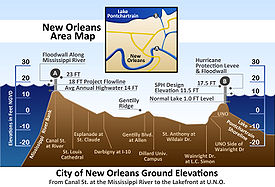
Many concerns focus around the fact that the city lies below sea level with a levee
Levee
A levee, levée, dike , embankment, floodbank or stopbank is an elongated naturally occurring ridge or artificially constructed fill or wall, which regulates water levels...
system that was designed for hurricanes of no greater intensity than Category 3
Saffir-Simpson Hurricane Scale
The Saffir–Simpson Hurricane Scale , or the Saffir–Simpson Hurricane Wind Scale , classifies hurricanes — Western Hemisphere tropical cyclones that exceed the intensities of tropical depressions and tropical storms — into five categories distinguished by the intensities of their sustained winds...
. Furthermore, its natural defenses, the surrounding marshland and the barrier island
Barrier island
Barrier islands, a coastal landform and a type of barrier system, are relatively narrow strips of sand that parallel the mainland coast. They usually occur in chains, consisting of anything from a few islands to more than a dozen...
s, have been dwindling in recent years. Just a few months before Katrina, the FX
FX Networks
FX is the name of a number of related pay television channels owned by News Corporation's Fox Entertainment Group...
docudrama Oil Storm
Oil Storm
Oil Storm is a 2005 television docudrama portraying a future oil-shortage crisis in the United States, precipitated by a hurricane destroying key parts of the United States' oil infrastructure...
depicted a Category 4 hurricane hitting New Orleans, killing thousands of people and forcing residents to evacuate and hide out in the Superdome, and speculated about a national economic meltdown caused by the decreased oil supply.
Hurricane Isidore
Hurricane IsidoreHurricane Isidore
Hurricane Isidore was the ninth named storm and the second hurricane in the 2002 Atlantic hurricane season. Isidore was the fifth of eight named storms to occur in September. The tropical cyclone peaked as a Category 3 hurricane, causing damage as well as four fatalities in Jamaica, Cuba, Mexico,...
in 2002 prompted some cautious New Orleanians to evacuate; the majority kept an eye on the news without leaving town.
LSU-USACE Study
In 2002 the Corps of Engineers, in conjunction with the Louisiana Water Resources Research Institute at Louisiana State UniversityLouisiana State University
Louisiana State University and Agricultural and Mechanical College, most often referred to as Louisiana State University, or LSU, is a public coeducational university located in Baton Rouge, Louisiana. The University was founded in 1853 in what is now known as Pineville, Louisiana, under the name...
(LSU), and the authorities in Jefferson Parish
Jefferson Parish, Louisiana
Jefferson Parish is a parish in Louisiana, United States that includes most of the suburbs of New Orleans. The seat of parish government is Gretna....
, modeled the effects and aftermath of a Category 5
Saffir-Simpson Hurricane Scale
The Saffir–Simpson Hurricane Scale , or the Saffir–Simpson Hurricane Wind Scale , classifies hurricanes — Western Hemisphere tropical cyclones that exceed the intensities of tropical depressions and tropical storms — into five categories distinguished by the intensities of their sustained winds...
strike on New Orleans. The model predicted an unprecedented disaster, with extensive loss of life and property. The study identified the problem: the New Orleans area is like a bowl, surrounded by levees which are strongest along the outer Mississippi and primarily intended to contain river flooding. When a hurricane drives water into Lake Pontchartrain
Lake Pontchartrain
Lake Pontchartrain is a brackish estuary located in southeastern Louisiana. It is the second-largest inland saltwater body of water in the United States, after the Great Salt Lake in Utah, and the largest lake in Louisiana. As an estuary, Pontchartrain is not a true lake.It covers an area of with...
, the weaker levees bordering Pontchartrain and canals leading to it are overwhelmed. Water then flows into the below-sea-level city, accompanied by water overflowing the levees along the Mississippi on the south side of the city center.
Hurricane Ivan
In 2004 Hurricane IvanHurricane Ivan
Hurricane Ivan was a large, long-lived, Cape Verde-type hurricane that caused widespread damage in the Caribbean and United States. The cyclone was the ninth named storm, the sixth hurricane and the fourth major hurricane of the active 2004 Atlantic hurricane season...
's threat to the city resulted in the largest evacuation of the city to date. Mayor Ray Nagin
Ray Nagin
Clarence Ray Nagin, Jr. is a former mayor of New Orleans, Louisiana, United States. Nagin gained international note in 2005 in the aftermath of Hurricane Katrina, which devastated the New Orleans area....
issued a call for a voluntary evacuation of the city at 6pm on September 13. An estimated 600,000 or more evacuated from Greater New Orleans. The contraflow plan was put into full effect for the first time, but rather late in the evacuation due to various confusions. This proved valuable practice, for the contraflow was implemented much more smoothly in 2005.
Hurricane Pam exercise
Hurricane Pam was a hypothetical hurricane used as a disaster scenario to drive planning for a 13-parish area in Southeastern Louisiana, including the city of New Orleans, in 2004. Developed by the Federal Emergency Management AgencyFederal Emergency Management Agency
The Federal Emergency Management Agency is an agency of the United States Department of Homeland Security, initially created by Presidential Reorganization Plan No. 1 of 1978 and implemented by two Executive Orders...
, the Louisiana Office of Homeland Security, Emergency Preparedness, the National Weather Service
National Weather Service
The National Weather Service , once known as the Weather Bureau, is one of the six scientific agencies that make up the National Oceanic and Atmospheric Administration of the United States government...
, and Innovative Emergency Management, Inc., the mock hurricane scenario and its projected consequences were the focal point of an eight-day exercise held at the State Emergency Operations Center in Baton Rouge in July, 2004. Hurricane Pam was a slow-moving Category 3
Saffir-Simpson Hurricane Scale
The Saffir–Simpson Hurricane Scale , or the Saffir–Simpson Hurricane Wind Scale , classifies hurricanes — Western Hemisphere tropical cyclones that exceed the intensities of tropical depressions and tropical storms — into five categories distinguished by the intensities of their sustained winds...
storm with sustained winds of 120 mph. It brought with it up to 20 inches (508 mm) of rain to some parts of southeastern Louisiana and caused levee-topping storm surge
Storm surge
A storm surge is an offshore rise of water associated with a low pressure weather system, typically tropical cyclones and strong extratropical cyclones. Storm surges are caused primarily by high winds pushing on the ocean's surface. The wind causes the water to pile up higher than the ordinary sea...
. The consequence assessment for Hurricane Pam indicated that more than one million people would be displaced and that 600,000 buildings would be damaged, with some completely destroyed. 60,000 people would be killed. The report on the simulation, TIME reported, warned that transportation would be a major problem in any storm situation paralleling the fictional "Hurricane Pam."
Follow-on Hurricane Pam workshops were conducted in November/December 2004, July 2005, and August 2005.
The Hurricane Pam scenario and the level of attention that the federal government paid to it were discussed following the catastrophic effects of Hurricane Katrina
Hurricane Katrina
Hurricane Katrina of the 2005 Atlantic hurricane season was a powerful Atlantic hurricane. It is the costliest natural disaster, as well as one of the five deadliest hurricanes, in the history of the United States. Among recorded Atlantic hurricanes, it was the sixth strongest overall...
on New Orleans in November and December, 2005.
On January 25, 2005, the Louisiana Sea Grant forum discussed additional results of several simulations of strong hurricanes hitting New Orleans.
Hurricane Cindy
Hurricane CindyHurricane Cindy (2005)
Hurricane Cindy was a tropical cyclone that briefly reached minimal hurricane strength in the Gulf of Mexico during July in the 2005 Atlantic hurricane season and made landfall in Louisiana. It was the third named storm and first hurricane of the season...
hit Louisiana at just barely hurricane strength on July 5, 2005. Many New Orleanians paid it little attention in advance, some having gotten blasé about threats of hurricanes which for decades had missed the city. However Cindy's winds gusted to 70 mi/h in the city, knocking branches off trees and causing New Orleans' largest blackout since Hurricane Betsy
Hurricane Betsy
Hurricane Betsy was a Category 4 hurricane of the 1965 Atlantic hurricane season which caused enormous damage in the Bahamas, Florida, and Louisiana. Betsy made its most intense landfall near the mouth of the Mississippi River, causing significant flooding of the waters of Lake Pontchartrain into...
in 1965. The experience encouraged many to evacuate when the much more powerful Hurricane Katrina was heading towards the city less than two months later.
Hurricane Katrina

Hurricane Katrina
Hurricane Katrina of the 2005 Atlantic hurricane season was a powerful Atlantic hurricane. It is the costliest natural disaster, as well as one of the five deadliest hurricanes, in the history of the United States. Among recorded Atlantic hurricanes, it was the sixth strongest overall...
threatened the city in August 2005. The eye of the huge storm grazed the eastern side of the city, sparing it from the worst of its power. However, due to poorly designed levees and the worst civil engineering failure in United States history, most of the city experienced flooding similar to a direct hit; see: Levee failures in Greater New Orleans, 2005
Levee failures in Greater New Orleans, 2005
In 29 August 2005 there were over 50 failures of the levees and flood walls protecting New Orleans, Louisiana, and its suburbs following passage of Hurricane Katrina and landfall in Mississippi. The levee and flood wall failures caused flooding in 80% of New Orleans and all of St. Bernard Parish...
.
There were many predictions of hurricane risk in New Orleans before Katrina.
On August 26 the storm, at one point up to a Category 5, was in the Gulf with a projection to possibly hit New Orleans a few days later. (The previous day the projected path was towards the Florida Panhandle.) On August 27 Mayor Nagin declared a state of emergency and called for a voluntary evacuation. The following day he issued the city's first ever whole-city mandatory evacuation order. A mandatory evacuation order is an extreme measure: the most recent such order in Louisiana occurred when east New Orleans was ordered evacuated in 1965.
There have been various plans to mitigate or prevent catastrophes. The evacuation plans were the most successful. The contraflow worked relatively smoothly, and over 80% of the population succeeded in fleeing the area in advance of the storm. The evacuation no doubt saved thousands of lives. However beyond the evacuation of those willing and able to leave town through their own resources, almost every other aspect of preparedness was found dreadfully wanting.
Like many other cities, New Orleans heavily relied on evacuation in case of a Category 5 storm. The inadequacy of evacuation plans was shown up when no provision was made in time to evacuate the large number of people– elderly, disabled, those without cars– who could not leave by their own means.
Blame for lack of preparedness has been leveled at all levels of government. New Orleans Mayor Ray Nagin
Ray Nagin
Clarence Ray Nagin, Jr. is a former mayor of New Orleans, Louisiana, United States. Nagin gained international note in 2005 in the aftermath of Hurricane Katrina, which devastated the New Orleans area....
has been criticized for not following the city's evacuation plan which called for the use of school buses to transport disadvantaged and elderly citizens out of the city. Louisiana Governor Kathleen Blanco
Kathleen Blanco
Kathleen Babineaux Blanco was the 54th Governor of Louisiana, having served from January 2004 until January 2008. She was the first woman to be elected to the office of governor of Louisiana....
was also criticized for not deploying the Louisiana National Guard
Louisiana National Guard
The Louisiana National Guard consists of the:*Louisiana Army National Guard** includes the U.S. 256th Infantry Brigade*Louisiana Air National Guard-External links:*** compiled by the United States Army Center of Military History...
sooner, although she did in fact deploy them before the hurricane hit and requested reinforcements from other states. President George W. Bush
George W. Bush
George Walker Bush is an American politician who served as the 43rd President of the United States, from 2001 to 2009. Before that, he was the 46th Governor of Texas, having served from 1995 to 2000....
and Homeland Security Secretary
United States Department of Homeland Security
The United States Department of Homeland Security is a cabinet department of the United States federal government, created in response to the September 11 attacks, and with the primary responsibilities of protecting the territory of the United States and protectorates from and responding to...
Michael Chertoff
Michael Chertoff
Michael Chertoff was the second United States Secretary of Homeland Security under President George W. Bush and co-author of the USA PATRIOT Act. He previously served as a judge on the United States Court of Appeals for the Third Circuit, as a federal prosecutor, and as assistant U.S. Attorney...
were also criticized for failures on the federal level as well as with his leadership role. FEMA chief Michael D. Brown
Michael D. Brown
Michael DeWayne Brown was the first Undersecretary of Emergency Preparedness and Response , a division of the Department of Homeland Security . This position is generally referred to as the director or administrator of the Federal Emergency Management Agency . He was appointed in January 2003 by...
admitted on the 1 year anniversary of landfall that "There was no plan" http://www.wdsu.com/news/9754112/detail.html?rss=no&psp=news and claimed that in the immediate aftermath of the disaster White House
White House
The White House is the official residence and principal workplace of the president of the United States. Located at 1600 Pennsylvania Avenue NW in Washington, D.C., the house was designed by Irish-born James Hoban, and built between 1792 and 1800 of white-painted Aquia sandstone in the Neoclassical...
officials told him to lie to put a more positive spin on the Federal response. http://www.msnbc.msn.com/id/14570837/
Hurricane relief plan vs. non-existent flood relief plan
One of the most significant planning failures was that there was no plan for the effects of a levee breach with the mass flooding that would result. After a typical hurricane hit the region, the plan would be for disaster relief forces to reach the city by overland routes. Since there was no New Orleans mass flooding and isolation by flooding plan, the plan that was pulled off the books was the hurricane relief plan. This plan failed because the relief personnel, most of whom were in trucks, could not get past nor thru the areas that were under water. That there was no mass flooding relief plan to be executed was obvious by the lack of any heavy-lift helicopters in relief forces that would have replaced the usual truck-born hurricane relief forces. A mass flooding with regional isolation plan would not have used land-based relief forces at all overland relief was impossible because of the barrier in place with the flooding.Louisiana Superdome fiasco
The designation by the city of the Louisiana Superdome as the "shelter of last resort" proved poor. It did not meet the safety standards required for a Red Cross shelter and thus it was not staffed by them or the Salvation ArmySalvation Army
The Salvation Army is a Protestant Christian church known for its thrift stores and charity work. It is an international movement that currently works in over a hundred countries....
. Thousands were trapped inside it as the area around it flooded and part of the roof blew off. Provisions for supplies were just barely adequate; sanitation, medical, and crowd control did not achieve that level. Since there was no flood-based federal nor state plan, heavy lift capacity helicopters that could have brought 16 tons of water, medical and food per flight were nowhere to be found. The much less effective hurricane-only response utilized much smaller UH and Black Hawk
Black Hawk
-People:* Black Hawk , a Sauk and Fox leader of the 19th century** The Black Hawk War, named after him.* Black Hawk , a Sans Arc Lakota artist of the 19th century* Antonga Black Hawk, a Ute leader known to whites as "Black Hawk"...
helicopters.
Under the National Response Plan
National Response Plan
The National Response Plan was a United States national plan to respond to emergencies such as natural disasters or terrorist attacks. It came into effect in December 2004 , and was superseded by the National Response Framework on March 22, 2008....
, disaster planning is first and foremost a local government responsibility. On the day after the Hurricane, Michael Chertoff
Michael Chertoff
Michael Chertoff was the second United States Secretary of Homeland Security under President George W. Bush and co-author of the USA PATRIOT Act. He previously served as a judge on the United States Court of Appeals for the Third Circuit, as a federal prosecutor, and as assistant U.S. Attorney...
invoked the National Response Plan, transferring emergency authority to the Department of Homeland Security.
Civil order broke down, infrastructure failed, and some 80% of the city flooded. A few government responders, including Coast Guard helicopters and Louisiana Fisheries & Wildlife Boats, responded early and worked hard to save lives of people stranded in the flooding, but their numbers were inadequate for the scope of the disaster. Private volunteers with boats assisted with rescue in great numbers, but significant Federal response was largely absent until 5 days after the disaster.
See also
- Effect of Hurricane Katrina on New OrleansEffect of Hurricane Katrina on New OrleansThe effects of Hurricane Katrina in New Orleans have been long-lasting. As the center of Katrina passed South-east of New Orleans on August 29, 2005, winds downtown were in the Category 3 range with frequent intense gusts and tidal surge. Hurricane force winds were experienced throughout the...
- Hurricane Katrina effects by regionHurricane Katrina effects by regionThis article covers the Hurricane Katrina effects by region, within the United States and Canada. The effects of Hurricane Katrina, in August 2005, were catastrophic and widespread. It was one of the deadliest natural disasters in U.S. history, leaving 1836 people dead, and a further 705 missing....
Post-Katrina

Hurricane Rita
Hurricane Rita was the fourth-most intense Atlantic hurricane ever recorded and the most intense tropical cyclone ever observed in the Gulf of Mexico. Rita caused $11.3 billion in damage on the U.S. Gulf Coast in September 2005...
headed towards the Gulf Coast as the city was still in ruins. Repopulation of some parts of the city had just begun when it was canceled and the city ordered re-evacuation. The levee system again failed, re-flooding low-lying portions of the city such as the Lower Ninth Ward
Lower Ninth Ward
Lower Ninth Ward is a neighborhood of the city of New Orleans. As the name implies, it is part of the Ninth Ward of New Orleans. The Lower Ninth Ward is often thought of as the entire area within New Orleans downriver of the Industrial Canal; however, the City Planning Commission divides this...
.
Hurricane Ernesto
Hurricane Ernesto (2006)
Hurricane Ernesto was the costliest tropical cyclone of the 2006 Atlantic hurricane season. The sixth tropical storm and first hurricane of the season, Ernesto developed from a tropical wave on August 24 in the eastern Caribbean Sea...
in 2006
2006 Atlantic hurricane season
The 2006 Atlantic hurricane season was significantly less active than the record previous season. It marked the first since 2001 in which no hurricanes made landfall in the United States, and was the first since 1994 that no tropical cyclones formed during October. Following the intense activity of...
originally threatened Louisiana
Louisiana
Louisiana is a state located in the southern region of the United States of America. Its capital is Baton Rouge and largest city is New Orleans. Louisiana is the only state in the U.S. with political subdivisions termed parishes, which are local governments equivalent to counties...
before hitting Florida
Florida
Florida is a state in the southeastern United States, located on the nation's Atlantic and Gulf coasts. It is bordered to the west by the Gulf of Mexico, to the north by Alabama and Georgia and to the east by the Atlantic Ocean. With a population of 18,801,310 as measured by the 2010 census, it...
, causing early preparations and rising oil prices.
Making landfall in Louisiana in late August 2008
2008 Atlantic hurricane season
The 2008 Atlantic hurricane season was a very active hurricane season with sixteen named storms formed, including eight that became hurricanes and five that became major hurricanes. The season officially started on June 1 and ended on November 30. These dates conventionally delimit the period of...
as a category two hurricane, Hurricane Gustav
Hurricane Gustav
The name Gustav has been used for five tropical cyclones in the Atlantic Ocean:* 1984's Tropical Storm Gustav - Spent most of its existence as a tropical depression hovering over Bermuda, no major damage was reported....
was the first to put large scale preparations in motion, although the storm was still in Caribbean on the third anniversary of Katrina. Locals were warned to prepare for a possible evacuation of the city and additional National Guard units were called out, and a state of emergency
State of emergency
A state of emergency is a governmental declaration that may suspend some normal functions of the executive, legislative and judicial powers, alert citizens to change their normal behaviours, or order government agencies to implement emergency preparedness plans. It can also be used as a rationale...
was declared. Soon afterwards, 1.9 million people were evacuated from southern Louisiana, including 200,000 from the City of New Orleans. Contraflow lanes were again initiated. Forty-three deaths occurred in Louisiana as a result of the storm.
Levee preparations and funding issues
While no detailed proposals had yet been made to augment the New Orleans levee system to be capable of withstanding a category 4Saffir-Simpson Hurricane Scale
The Saffir–Simpson Hurricane Scale , or the Saffir–Simpson Hurricane Wind Scale , classifies hurricanes — Western Hemisphere tropical cyclones that exceed the intensities of tropical depressions and tropical storms — into five categories distinguished by the intensities of their sustained winds...
or greater hurricane, in October 2004, the Corps of Engineers submitted a proposal to Congress requesting $
United States dollar
The United States dollar , also referred to as the American dollar, is the official currency of the United States of America. It is divided into 100 smaller units called cents or pennies....
4 Million to fund a preliminary study for such a plan. Congress tabled the proposal, never addressing it on the floor, citing budgetary concerns resulting from the Iraq War. A senior Corps official made an off-hand estimate that this project would require approximately $
United States dollar
The United States dollar , also referred to as the American dollar, is the official currency of the United States of America. It is divided into 100 smaller units called cents or pennies....
1 Billion dollars and would take 20 years, stating "It's possible to protect New Orleans from a Category 5 hurricane... we've got to start. To do nothing is tantamount to negligence." Whether or not such additional funding might have been capable of preventing the extensive flooding in New Orleans caused by Katrina, is a matter that has yet to be determined.
Starting in 2003, federal spending on the Southeast Louisiana Project was substantially reduced. Lt. General Carl Strock, Chief of Engineers
Chief of Engineers
The Chief of Engineers commands the US Army Corps of Engineers. As a staff officer at The Pentagon, the Chief advises the Army on engineering matters and serves as the Army's topographer and the proponent for real estate and other related engineering programs....
at the Corps of Engineers, said that, "at the time that these levees were designed and constructed, it was felt that that was an adequate level given the probability of an event like this occurring." Strock also said that he did not believed that funding levels contributed to the disaster, commenting that, "the intensity of this storm simply exceeded the design capacity of this levee." Strock also told reporters that the Corps of Engineers "had a 200- or 300-year level of protection. That means that an event that we were protecting from might be exceeded every 200 or 300 years."
From 2001 through 2005, the Bush administration battled with Congress to cut a total of approximately 67% from the budgetary requests from the Corps of Engineers for levee augmentation projects in the New Orleans area, but ultimately settled with Congress on a 50% cut in these budgetary requests. In February 2004, Naomi stated that, "I've got at least six levee construction contracts (in the New Orleans area where funding has been cut) that need to be done to raise the levee protection back to where it should be (because of settling). Right now I owe my contractors about $
United States dollar
The United States dollar , also referred to as the American dollar, is the official currency of the United States of America. It is divided into 100 smaller units called cents or pennies....
5 Million. And we're going to have to pay them interest."
Even as the Bush administration was cutting the Corps of Engineers budget, many were criticizing the administration for not cutting the budget more. The New York Times, in particular, published several editorials criticizing the large size of the $
United States dollar
The United States dollar , also referred to as the American dollar, is the official currency of the United States of America. It is divided into 100 smaller units called cents or pennies....
17 Billion Corps budget, and called for the Senate to cut, "pork," in S. 728, which would have provided $
United States dollar
The United States dollar , also referred to as the American dollar, is the official currency of the United States of America. It is divided into 100 smaller units called cents or pennies....
512 Million in funding for hurricane protection projects in southern Louisiana.
Just after Hurricane Katrina hit, there was some concern expressed that government officials have placed an overemphasis on disaster recovery, while neglecting the process of pre-planning and preparation.
In the 17 months following Katrina, five investigations were carried out. The only federally ordered study was conducted by the American Society of Civil Engineers
American Society of Civil Engineers
The American Society of Civil Engineers is a professional body founded in 1852 to represent members of the civil engineering profession worldwide. It is the oldest national engineering society in the United States. ASCE's vision is to have engineers positioned as global leaders who strive toward...
and paid for by the United States Army Corps of Engineers
United States Army Corps of Engineers
The United States Army Corps of Engineers is a federal agency and a major Army command made up of some 38,000 civilian and military personnel, making it the world's largest public engineering, design and construction management agency...
. Two major independent studies were done by the University of California at Berkeley and the Louisiana State University. Two minor studies were done by FEMA and the insurance industry. All five studies basically agree on the engineering mechanisms of failure.
The failure mechanisms included overtopping of levees and floodwalls by the storm surge, consequential undermining of flood wall foundations or other weakening by water of the wall foundations, and the storm surge pressures exceeding the strength of the floodwalls. In June 2006, a contrite Lt. Gen Carl Strock took responsibility for the failure of metro New Orleans flood protection, calling the system "a system in name only."
As of August 2006, the Corps of Engineers planned to spend $6 billion to make sure that by 2010, the city would probably be flooded only once every 100 years. But this would not equal the best levee system in the world, which is in The Netherlands. That system is designed to protect populated areas against anything but a 1-in-10,000-years flood. If the Corps built a 1-in-500-year levee system in New Orleans, Ivan van Heerden, deputy director of Louisiana State University's Hurricane Center, says, it would cost $30 billion.
According to a study by the National Academy of Engineering
National Academy of Engineering
The National Academy of Engineering is a government-created non-profit institution in the United States, that was founded in 1964 under the same congressional act that led to the founding of the National Academy of Sciences...
and the National Research Council
United States National Research Council
The National Research Council of the USA is the working arm of the United States National Academies, carrying out most of the studies done in their names.The National Academies include:* National Academy of Sciences...
, levees and floodwalls surrounding New Orleans—no matter how large or sturdy—cannot provide absolute protection against overtopping or failure in extreme events. Levees and floodwalls should be viewed as a way to reduce risks from hurricanes and storm surges, not as measures that completely eliminate risk. For structures in hazardous areas and residents who do not relocate, the committee recommended major floodproofing measures such as elevating the first floor of buildings to at least the 100-year flood level.
Louisiana's sinking coast
When the Corps of EngineersUnited States Army Corps of Engineers
The United States Army Corps of Engineers is a federal agency and a major Army command made up of some 38,000 civilian and military personnel, making it the world's largest public engineering, design and construction management agency...
started systematically leveeing the river in the 19th century, it cut off the region's main source of silt, the raw material of delta-building in the Mississippi Delta
Mississippi Delta
The Mississippi Delta is the distinctive northwest section of the U.S. state of Mississippi that lies between the Mississippi and Yazoo Rivers. The region has been called "The Most Southern Place on Earth" because of its unique racial, cultural, and economic history...
and the Wetlands of Louisiana
Wetlands of Louisiana
The wetlands of Louisiana are water-saturated coastal and swamp regions of southern Louisiana.The Environmental Protection Agency defines wetlands as "those areas that are inundated or saturated by surface or groundwater at a frequency and duration sufficient to support, and that under normal...
. The weight of large buildings and infrastructure and the leaching of water, oil and gas from beneath the surface across the region have also contributed to the problem. Following the great floods of 1927, the Mississippi River was surrounded by a series of levees meant to protect the city from such floods. In 1965, New Orleans was hit by Hurricane Betsy
Hurricane Betsy
Hurricane Betsy was a Category 4 hurricane of the 1965 Atlantic hurricane season which caused enormous damage in the Bahamas, Florida, and Louisiana. Betsy made its most intense landfall near the mouth of the Mississippi River, causing significant flooding of the waters of Lake Pontchartrain into...
, which caused tremendous flooding in the New Orleans area. The federal government began a levee-building program to protect New Orleans from a Category 3
Saffir-Simpson Hurricane Scale
The Saffir–Simpson Hurricane Scale , or the Saffir–Simpson Hurricane Wind Scale , classifies hurricanes — Western Hemisphere tropical cyclones that exceed the intensities of tropical depressions and tropical storms — into five categories distinguished by the intensities of their sustained winds...
hurricane (the same strength as Betsy). These series of levees were completed in recent years before Hurricane Katrina.
However, an unintended consequence
Unintended consequence
In the social sciences, unintended consequences are outcomes that are not the outcomes intended by a purposeful action. The concept has long existed but was named and popularised in the 20th century by American sociologist Robert K. Merton...
of the levees was that natural silt deposits from the Mississippi River were unable to replenish the delta, causing the coastal wetlands of Louisiana to wash away and the city of New Orleans to sink even deeper. The Mississippi River delta is subsiding faster than any other place in the nation. While the land is sinking, sea level has been rising. In the past 100 years, land subsidence and sea-level rise have recently added three feet to all storm surge
Storm surge
A storm surge is an offshore rise of water associated with a low pressure weather system, typically tropical cyclones and strong extratropical cyclones. Storm surges are caused primarily by high winds pushing on the ocean's surface. The wind causes the water to pile up higher than the ordinary sea...
s. That extra height puts affected areas under deeper water; it also means flooding from weaker storms and from the outer edges of powerful storms spreads over wider areas. The marshes that ring New Orleans, as well as the land depression of the city itself, originally above sea level
Sea level
Mean sea level is a measure of the average height of the ocean's surface ; used as a standard in reckoning land elevation...
, have sunk the quickest.
The problem with the wetlands was further worsened by salt water intrusion caused by the canals dug by the oil companies and private individuals in this marshland. This erosion of the wetlands not only caused Louisiana to lose 24 square miles (62.2 km²) per year of land annually and 1900 square miles (4,921 km²) of land since the 1930s, but it also destroyed Louisiana’s first line of defense against hurricanes.
Hurricanes draw their strength from the sea, so they quickly weaken and begin to dissipate when they make landfall. Hurricanes moving over fragmenting marshes toward the New Orleans area can retain more strength, and their winds and large waves pack more speed and destructive power. Scientists working for the Louisiana Department of Natural Resources measured some of these effects during Hurricane Andrew
Hurricane Andrew
Hurricane Andrew was the third Category 5 hurricane to make landfall in the United States, after the Labor Day Hurricane of 1935 and Hurricane Camille in 1969. Andrew was the first named storm and only major hurricane of the otherwise inactive 1992 Atlantic hurricane season...
in 1992. Andrew's surge height dropped from 9.3 feet (2.8 m) at Cocodrie to 3.3 feet (1 m) at the Houma Navigation Canal 23 miles (37 km) to the north. For every mile of the marsh-and-water landscape it traversed, it lost 3.1 inches of height, sparing some homes farther north from more flooding. Currently Louisiana has 30% of the total coastal marsh and accounts for 90% of the coastal marsh loss in the lower 48 states. The engineering of the river has basically brought the Gulf of Mexico much closer New Orleans, making it more vulnerable to hurricanes.
The combination of sinking land and rising seas has place the Mississippi River delta as much as 3 foot (0.9144 m) lower relative to sea level than it was a century ago, and the process continues. That means hurricane floods driven inland from the Gulf have risen by corresponding amounts. Storms that once would not have had much impact can now be devastating events, and flooding now penetrates into places where it has rarely occurred before. The problem also is slowly eroding levee protection, cutting off evacuation routes sooner and putting dozens of communities and valuable infrastructure at risk of being wiped out by the flooding.
State and federal officials have recently pushed a $
United States dollar
The United States dollar , also referred to as the American dollar, is the official currency of the United States of America. It is divided into 100 smaller units called cents or pennies....
14 billion plan to rebuild wetlands over the next 30 years, to be funded by oil and gas royalties, called Coast 2050.
Louisiana will receive $
United States dollar
The United States dollar , also referred to as the American dollar, is the official currency of the United States of America. It is divided into 100 smaller units called cents or pennies....
540 million under the energy bill enacted in August 2005. More money for this program is likely to come with aid from Hurricane Katrina. The original actual cost needed for the project, however, was $
United States dollar
The United States dollar , also referred to as the American dollar, is the official currency of the United States of America. It is divided into 100 smaller units called cents or pennies....
14 billion.
Wetlands have the capacity to absorb storm surges at the rate of 1 foot (0.3048 m) per 2.7 miles (4.3 km). However, due to the systematic, long-term nature of wetland loss, and because wetland remediation can take decades, it is not possible to pinpoint blame for wetland loss on any specific Congress, legislature, President, or governor.
External links
- Levees.Org (non-profit in New Orleans)
- State of Louisiana Emergency Operations Plan
- State of Louisiana Emergency Operations Plan Supplement 1A Southeast Louisiana Hurricane Evacuation and Sheltering Plan
- City of New Orleans Hurricane Preparedness Plan
- Nova Television Show on hurricane threat to New Orleans
- Independent Levee Investigation Team Draft Report
- Hurricane Katrina Blame Game
- Final Report: U.S. House of Representatives Select Bipartisan Committee to Investigate the Preparation for and Response to Hurricane Katrina