
Chiang Rai Province
Encyclopedia
Chiang Rai is the northernmost province
(changwat) of Thailand
. Neighbouring provinces are (from east clockwise) Phayao
, Lampang
and Chiang Mai
. In the north it borders Shan State
of Myanmar
and Bokeo of Laos
.
, at which the borders of Thailand, Laos and Myanmar converge - an area which was very unsafe because of the drug smuggling
across the borders. The Mekong
river forms the boundary with Laos, the Mae Sai
and Ruak River
to Myanmar. Through the town of Chiang Rai
itself flows the Kok River
.
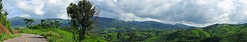
While the eastern part of the province is relatively flat river plains, the western part consists of the mountainous terrain of the Hills of Northern Thailand
.
While not the highest elevation of the province, the 1389 m high Doi Tung
(Flag hill) is the most important hill. The Wat Phra That Doi Tung temple on top of the hill according to the chronicles dates back to the year 911. Nearby is the Doi Tung royal villa, former residence of the Late Princess mother (mother of the present king) Somdej Phra Srinagarindra
. Thanks to her activities the hills were reforested, and the hill tribes changed from growing poppy to other crops.

Chiang Rai became a province in 1910, after being part of the kingdom of Lannathai for centuries. After Lannathai was incorporated into Thailand, it stayed an autonomous region and thus the Chiang Rai area was administered from Chiang Mai.
Chiang Rai province's Golden Triangle bordering Laos and Burma was once the hub of opium production which had much influence on cultural practices and lifestyles. Until this day, entire clans live together in bamboo houses and each village has its own individual character.
, but 12.5% of the population belong to the hill tribes, a minority in the North of Thailand. A minority are of Chinese
descent, mainly descendants of the Kuomintang
soldiers who settled in the region, notably Santikhiri
.
shows a white elephant
, the royal symbol. It remembers that Chiang Rai was founded by King Mengrai
, according to the legend because his elephant liked the place.
The provincial tree is the Tree Jasmine (Radermachera ignea), and the provincial flower is the Orange Trumpet (Pyrostegia venusta).
The former provincial slogan saids:
"เหนือสุดในสยาม อร่ามดอยตุง ผดุงวัฒนธรรม รสล้ำข้าวสาร หอมหวานลิ้นจี่ สตรีโสภา ชาเลิศรส สัปปะรดนางแล"
Northernmost in Siam, beautiful Doi Tung, repository of culture, most delicious rice, sweet and fragrant litchi, beautiful women, the finest flavoured tea, pineapple from Nang-Lae .
While the current says "เหนือสุดในสยาม ชายแดนสามแผ่นดิน ถิ่นวัฒนธรรมล้านนา ล้ำค่าพระธาตุดอยตุง"
The northernmost of Siam, the frontiere of three lands, the home to the culture of Lanna and Doi Tung Temple
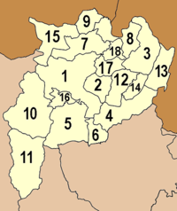 The province is subdivided in 18 districts (amphoe
). These are further subdivided into 124 subdistricts (tambon
) and 1510 villages (muban
).
in Indonesia
to Kosravi in Iran
, and by Asian Highway 3, which runs for over 7000 km (4,349.6 mi) from Kentung in Myanmar to Ulan-Ude
in Russia
.
Rail
There is no railway system in Chiang Rai.
Bus service
Decent bus services are available in the province but in more remote areas, songthaew
s (public passenger pick-up vehicles) are the norm.
Air
Chiang Rai International Airport
at the moment only sees domestic flights.
 The province is rich in tourism resources in terms of natural attractions and antiquities, evidence of its past civilisation. It is also home to various hilltribes who follow fascinating ways of life. Chiang Rai is also a tourism gateway into Myanmar
and Laos
.
cultural objects.
Doi Tung (ดอยตุง) is a revered mountain which includes the Doi Tung Palace and the Mae Fa Luang Flower Garden. The Wat Phra That Doi Tung Holy Relic, an old religious site on top of the mountain, is about 2,000 metres above sea level.
Wat Rong Khun
(วัดร่องขุ่น): This temple was designed and built by artist Chaloemchai Khositphiphat. A white ordination hall – Phra Ubosot - is decorated with silver glittering pieces of mirrors. There are large mural paintings of the Lord Buddha in different gestures.
The Golden Triangle
(สามเหลี่ยมทองคำ), locally called "Sop Ruak", is where the Mekhong meets the Ruak River
and also where the borders of three countries, Laos, Burma and Thailand, meet together. There are remains of many ancient places and structures attesting to the area having been settled by people in the past.
Doi Mae Salong (ดอยแม่สลอง) is home to a community settled by remnants of the 93rd Division of the Republic of China Army
, who moved out of Yunnan province, China
, in to Burma and after to Thai territory at the end of the Chinese Civil War
in 1949. Today the town is a tourist attraction renowned for its tea and its small-town ambience on high hills.
Wat Phra Kaeo
(วัดพระแก้ว) once housed Thailand's most revered Buddha image, the Emerald Buddha
. It was discovered in 1444. The statue had been moved by various state rulers to be placed in their respective capitals as a symbol of dominance, including Lampang, Chiang Rai and Vientiane before finally enshrined in Bangkok's Wat Phra Kaeo during the reign of King Rama I of the Rattanakosin period.
Kok River
(แม่น้ำกก) flows through the town of Chiang Rai and is 130 kilometres long. Long-tailed boats and cruises can be made from town to travel. Hilltribe villages in the area are popular with travelers.
Amphoe Mae Sai
: Mae Sai (แม่สาย), borders on Burma's Tachileik
(ท่าขี้เหล็ก) marked by the Mae Sai River with a bridge spanning both sides. The area has a market selling lots of different goods.
Doi Nang Non
(ดอยนางนอน), "sleeping woman mountain", is unusual land feature located in Mae Chan
district on the western side of the highway between Chiang Rai and Mae Sai. The silhouette of the mountain range takes the shape of a reclining woman when seen from certain angles. There is a viewpoint at Mae Chan, from where this land feature can be observed best.
The Hall of Opium, Golden Triangle Park (หอฝิ่นอุทยานสามเหลี่ยมทองคำ) exhibits the history of opium
in the Golden Triangle, its origin, opium war when people lived on opium planting and smoking, as well as the recovery of the people who lived here.
Chiang Saen
(เชียงแสน): an ancient town which once served as the main town before King Mengrai established Chiang Rai as the capital of the Lanna Kingdom in 1262. Traces of old double city walls and many other antiquities still remain in and outside the district town. The attractions include Chiang Saen National Museum (พิพิธภัณฑสถานแห่งชาติเชียงแสน), Wat Phra That Chedi Luang (วัดพระธาตุเจดีย์หลวง) and Wat Pa Sak (วัดป่าสัก).
Phu Chi Fa (ภูชี้ฟ้า): There is a trail which leads from a parking lot up to the viewing point on the top of this mountain, a distance of 1.8 kilometres. From the sheer cliff of Phu Chi Fa, views, especially the sea of clouds at sunrise, can be seen. The cool climate produces flowering shrubs of various species.
Santiburi Chiang Rai is one of the best courses in the country and is only 15 minutes from the city. Waterford is an attractive course about 45 minutes north of Chiang Rai city. The Military course is on the way to the Mae Fah Luang Bridge, not far from the Dusit Hotel. The old airport has a 9 hole course.
Long Tail Boat Ride
A long tail boat ride on the Kok River is a fun way to experience the scenery and see hill tribe villages. There are daily trips from Thaton, near the Burmese border to Chiang Rai. The main boat station is on the north side of the Mae Fah Luang Bridge, not far from the Rimkok Hotel.
Elephant Riding
Elephant riding is possible at Baan Ruamit, about 30 minutes from Chiang Rai by car or 1 hour by long tail boat ride.
Disc Golf
Also known as 'Frisbee Golf' - there is a 9 hole course 2km NW of Chiang Rai town, in a lovely park with rock formations and tall shade trees.
An extensive network of trails mainly used by hill tribe villagers covers the mountain areas of Mae Suai, Mae Salong, Doi Chaang and the banks along the Mae Kok River.
Rock Climbing Limestone karst hills are peppered throughout the province, some have straight-up sides - potentially great for climbing, though often vine covered. There are several locations around Chiang Rai which have been cleared, also containing ziplines.
Mountain Biking
Chiang Rai has incredible mountain biking because of the extensive network of paved roads with little traffic and dirt roads in the mountains. A nice day ride is to start in the city, go out to the elephant village and continue on past it until you find a small single track suspension bridge. Cross it and turn left, back towards Chiang Rai. On the way you will pass two hot springs and eventually end up back in the city.
Caving 1 Km up the Mae Kok river, west of Chiang Rai town, is 'Crouching Lion Hill.' It parallels the Mae Kok river and has a Buddha cave on its west end, and an easy-access cave near its east end. The eastern cave is actually a 3-chambered cave, each with a natural skylight at its apex, the largest chamber is as big as a giant sequoia tree. Trekkers can use it to walk through the entire hill.
Tai Yai, Burmese in origin, harvest rice, farm, raise cattle and trade. Their craftsmanship lies in weaving, pottery, wood carving and bronzeware.
Akha have the largest population of any hill tribe in the region. Originating from Tibet and Southern China, they dwell on high grounds around 1,200 meters above sea-level. Within their villages they build a Spirit Gateway to protect them from evil spirits.
Lahu are also from the Yunnese area and live in high areas. They are known as hunters and planters.
Karen live in various areas of the region which have valleys and riverbanks.
Chin Hor, these are the former Kuomintang who took refuge in the area, mainly Doi Mae Salong
Hmong from southern China are located on high land. They raise livestock and grow rice, corn, tobacco and cabbage. They are also known for their embroidery and silver.
Tai Lue live in dwellings of usually only a single room wooden house built on high poles. They are skilled in weaving.
Lisaw from southern China and Tibet are renowned for their colorful dress and also build their dwellings on high poles. They harvest rice and corn and their men are skilled in hunting.
Yao reside along mountain sides and grow corn and other crops. They are skilled blacksmiths, silversmiths and embroiders.
Dok Siao Ban or Blooming Siao Flower Festival at Phu Chi Fa (งานดอกเสี้ยวบานที่ภูชี้ฟ้า) is held during 13–15 February. There are sports competitions and cultural performances from hilltribes at Ban Rom Fa Thai in Amphoe Thoeng.
Songkran Festival and Boat Races of Mueang Chiang Saen (งานประเพณีสงกรานต์และแข่งเรือเมืองเชียงแสน) is held during 13–18 April of each year. In this festival, there is a parade, water bathing ceremony of the Phrachao Lanthong Buddha image, boat races and folk performances.
Lichi Fair (งานเทศกาลลิ้นจี่และของดีเมืองเชียงราย) is held around the middle of May every year. There is a float competition, Lichi beauty contest and booths of many products at the provincial stadium of Chiang Rai.
Buatong Ban or Blooming Mexican Sunflower Festival (งานเทศกาลดอกบัวตองบาน) is held in November, affording people the opportunity to see the sunflower fields, waterfalls and mist at Ban Hua Mae Kham, Amphoe Mae Fa Luang. There are also hilltribe performances.
Chiang Rai Flower Festival (งานเทศกาลเชียงรายดอกไม้บาน) is held during the end of December to January every year. There are flower processions, flower gardens, Miss Thinn Thai Ngarm Contest and also the fair of agricultural products and the variety of flowers.
Chiang Saen, Mae Chan, and Doi Mae Salong are three substantially different places. Chiang Saen's culture has been influenced by its collection of Buddhist scriptures and temples. It was once the provincial capital. Mae Chan's name lies in its silver and tribal handicrafts. Once officially unrecognized by the Thai government, Doi Mae Salong is a Chinese KMT (Kuomintang) area renowned for its natural beauty and unique Yunnanese culture.
Besides the Chinese 93rd Infantry of the Kuomintang, several other ethnic minorities have settled down in the region including the Tai Yai, Tai Lue, Tai Khoen and Tai Yuan.
Provinces of Thailand
Thailand is divided into 76 provinces , which are geographically grouped into 6 regions. The capital Bangkok is not a province but a special administrative area and is included as the 77th province since it is administered at the same level as the other 76 provinces. The name of the provinces are...
(changwat) of Thailand
Thailand
Thailand , officially the Kingdom of Thailand , formerly known as Siam , is a country located at the centre of the Indochina peninsula and Southeast Asia. It is bordered to the north by Burma and Laos, to the east by Laos and Cambodia, to the south by the Gulf of Thailand and Malaysia, and to the...
. Neighbouring provinces are (from east clockwise) Phayao
Phayao Province
Phayao is one of the northern provinces of Thailand. Neighboring provinces are Nan, Phrae, Lampang and Chiang Rai. In the north-east it borders Xaignabouli of Laos.- Geography :...
, Lampang
Lampang Province
Lampang is one of the northern provinces of Thailand. Neighboring provinces are Chiang Rai, Phayao, Phrae, Sukhothai, Tak, Lamphun and Chiang Mai. The old name of Lampang is Khelang Nakhon.-Geography:...
and Chiang Mai
Chiang Mai Province
Chiang Mai is the second-largest province of Thailand, located in the north of the country. Neighboring provinces are Chiang Rai, Lampang, Lamphun, Tak, and Mae Hong Son. In the north it borders Shan State of Burma...
. In the north it borders Shan State
Shan State
Shan State is a state of Burma . Shan State borders China to the north, Laos to the east, and Thailand to the south, and five administrative divisions of Burma in the west. Largest of the 14 administrative divisions by land area, Shan State covers 155,800 km², almost a quarter of the total...
of Myanmar
Myanmar
Burma , officially the Republic of the Union of Myanmar , is a country in Southeast Asia. Burma is bordered by China on the northeast, Laos on the east, Thailand on the southeast, Bangladesh on the west, India on the northwest, the Bay of Bengal to the southwest, and the Andaman Sea on the south....
and Bokeo of Laos
Laos
Laos Lao: ສາທາລະນະລັດ ປະຊາທິປະໄຕ ປະຊາຊົນລາວ Sathalanalat Paxathipatai Paxaxon Lao, officially the Lao People's Democratic Republic, is a landlocked country in Southeast Asia, bordered by Burma and China to the northwest, Vietnam to the east, Cambodia to the south and Thailand to the west...
.
Geography
The average elevation of the province is 580 m. The north of the province belongs to the so-called Golden TriangleGolden Triangle (Southeast Asia)
The Golden Triangle is one of Asia's two main illicit opium-producing areas. It is an area of around that overlaps the mountains of four countries of Southeast Asia: Burma, Vietnam, Laos, and Thailand. Along with Afghanistan in the Golden Crescent and Pakistan, it has been one of the most...
, at which the borders of Thailand, Laos and Myanmar converge - an area which was very unsafe because of the drug smuggling
Smuggling
Smuggling is the clandestine transportation of goods or persons, such as out of a building, into a prison, or across an international border, in violation of applicable laws or other regulations.There are various motivations to smuggle...
across the borders. The Mekong
Mekong
The Mekong is a river that runs through China, Burma, Laos, Thailand, Cambodia and Vietnam. It is the world's 10th-longest river and the 7th-longest in Asia. Its estimated length is , and it drains an area of , discharging of water annually....
river forms the boundary with Laos, the Mae Sai
Mae Sai River
Mae Sai River is a river that is the natural border between Thailand and Myanmar. It passes under Phahonyothin Road.Upstream of the Mae Sai River was located at Myanmar....
and Ruak River
Ruak River
The Ruak River is a river at the Thai-Burma border. It originates within the hills of the Shan State , and becomes the boundary river between Thailand and Burma at the confluence with the Mae Sai River at the northernmost point of Thailand. It then meanders to the east until it empties into the...
to Myanmar. Through the town of Chiang Rai
Chiang Rai
-Demographics:Official Population count: According to the Thailand National Statistical Office, as of September 2010, Chiang Rai municipal district has a population of 199,699...
itself flows the Kok River
Kok River
The Kok River originates in Shan State, Burma. It flows down and across the Burma-Thailand border to Mae Ai district, Chiang Mai Province, passing under Phahonyothin Road. Most of its length is in Chiang Rai Province passing the districts Mueang Chiang Rai, Mae Chan, Chiang Saen and Wiang Chai. It...
.
While the eastern part of the province is relatively flat river plains, the western part consists of the mountainous terrain of the Hills of Northern Thailand
Thai highlands
The Thai Highlands are mountains in the north of Thailand that are part of the range of hills extending through Laos, Burma and China and linking to the Himalayas, of which they may be considered foothills.-Geography:...
.
While not the highest elevation of the province, the 1389 m high Doi Tung
Doi Tung
Doi Tung , "Flag Mountain", is a mountain located in Chiang Rai Province, Thailand.-Location:While not the highest elevation of the province, the 1389 m high Doi Tung rises steeply, standing quite isolated close to the Thailand-Burma border. It is located in the area known as "Golden...
(Flag hill) is the most important hill. The Wat Phra That Doi Tung temple on top of the hill according to the chronicles dates back to the year 911. Nearby is the Doi Tung royal villa, former residence of the Late Princess mother (mother of the present king) Somdej Phra Srinagarindra
Srinagarindra
Srinagarindra was a member of the Thai Royal Family and was a member of House of Mahidol, which is descended from Chakri Dynasty, originated by Prince Mahidol Adulyadej, the Prince of Songkla, son of King Chulalongkorn...
. Thanks to her activities the hills were reforested, and the hill tribes changed from growing poppy to other crops.
Climate
History
Populations have dwelled in Chiang Rai since the 7th century and it became the center of the Lanna Thai Kingdom during the 13th century. The region, rich in natural resources and textiles, was occupied by the Burmese until 1786.Chiang Rai became a province in 1910, after being part of the kingdom of Lannathai for centuries. After Lannathai was incorporated into Thailand, it stayed an autonomous region and thus the Chiang Rai area was administered from Chiang Mai.
Chiang Rai province's Golden Triangle bordering Laos and Burma was once the hub of opium production which had much influence on cultural practices and lifestyles. Until this day, entire clans live together in bamboo houses and each village has its own individual character.
Demographics
The majority of the population are generally ethnic ThaiThai people
The Thai people, or Siamese, are the main ethnic group of Thailand and are part of the larger Tai ethnolinguistic peoples found in Thailand and adjacent countries in Southeast Asia as well as southern China. Their language is the Thai language, which is classified as part of the Kradai family of...
, but 12.5% of the population belong to the hill tribes, a minority in the North of Thailand. A minority are of Chinese
Thai Chinese
The Thai Chinese are an overseas Chinese community who live in Thailand. Thailand is home to the largest, oldest, most prominent, and most integrated overseas Chinese community in the world with a population of approximately 9.5 million people...
descent, mainly descendants of the Kuomintang
Kuomintang
The Kuomintang of China , sometimes romanized as Guomindang via the Pinyin transcription system or GMD for short, and translated as the Chinese Nationalist Party is a founding and ruling political party of the Republic of China . Its guiding ideology is the Three Principles of the People, espoused...
soldiers who settled in the region, notably Santikhiri
Santikhiri
The village of Santikhiri , formerly known as Mae Salong , is situated on the mountain of Doi Mae Salong, in Mae Fa luang district, Chiang Rai Province, the northernmost province of Thailand...
.
Symbols
The seal of the provinceSeals of The Provinces of Thailand
-Present-day provinces of Thailand:This list includes all the seals of the Provinces of Thailand. It also includes the special administrative area of the capital, Bangkok.-Former Provinces:-External links:*...
shows a white elephant
White elephant
A white elephant is an idiom for a valuable but burdensome possession of which its owner cannot dispose and whose cost is out of proportion to its usefulness or worth...
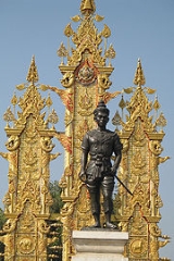
, the royal symbol. It remembers that Chiang Rai was founded by King Mengrai
Mengrai
King Mangrai was the 25th King of Ngoen Yang and the first King of Chiang Mai , capital of the Lanna Kingdom .-Early years:...
, according to the legend because his elephant liked the place.
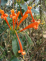
The provincial tree is the Tree Jasmine (Radermachera ignea), and the provincial flower is the Orange Trumpet (Pyrostegia venusta).
The former provincial slogan saids:
"เหนือสุดในสยาม อร่ามดอยตุง ผดุงวัฒนธรรม รสล้ำข้าวสาร หอมหวานลิ้นจี่ สตรีโสภา ชาเลิศรส สัปปะรดนางแล"
Northernmost in Siam, beautiful Doi Tung, repository of culture, most delicious rice, sweet and fragrant litchi, beautiful women, the finest flavoured tea, pineapple from Nang-Lae .
While the current says "เหนือสุดในสยาม ชายแดนสามแผ่นดิน ถิ่นวัฒนธรรมล้านนา ล้ำค่าพระธาตุดอยตุง"
The northernmost of Siam, the frontiere of three lands, the home to the culture of Lanna and Doi Tung Temple
Administrative divisions
Amphoe
An amphoe is the second level administrative subdivision of Thailand. Usually translated as district, amphoe make up the provinces, and are analogous to a county seat...
). These are further subdivided into 124 subdistricts (tambon
Tambon
Tambon is a local government unit in Thailand. Below district and province , they form the third administrative subdivision level. As of the 2009 there are 7255 tambon, not including the 169 khwaeng of Bangkok, which are set at the same administrative level, thus every district contains 8-10 tambon...
) and 1510 villages (muban
Muban
Muban is the lowest administrative subdivision of Thailand. Usually translated as village, they are the subdivision of tambon. As of 2008, there are 74944 administrative villages in Thailand. As of the 1990 census, the average village consisted of 144 households or 746 persons.A muban does not...
).
|
|
Transportation
Chiang Rai province is intersected by Asian Highway 2, which runs over 13.000 km (over 8000 miles) from DenpasarDenpasar
Denpasar is the capital city of the province of Bali, Indonesia. It has a rapidly expanding population of 788,445 in 2010, up from 533,252 in the previous decade. It is located at .-History:...
in Indonesia
Indonesia
Indonesia , officially the Republic of Indonesia , is a country in Southeast Asia and Oceania. Indonesia is an archipelago comprising approximately 13,000 islands. It has 33 provinces with over 238 million people, and is the world's fourth most populous country. Indonesia is a republic, with an...
to Kosravi in Iran
Iran
Iran , officially the Islamic Republic of Iran , is a country in Southern and Western Asia. The name "Iran" has been in use natively since the Sassanian era and came into use internationally in 1935, before which the country was known to the Western world as Persia...
, and by Asian Highway 3, which runs for over 7000 km (4,349.6 mi) from Kentung in Myanmar to Ulan-Ude
Ulan-Ude
Ulan-Ude is the capital city of the Republic of Buryatia, Russia, located about southeast of Lake Baikal on the Uda River at its confluence with the Selenga...
in Russia
Russia
Russia or , officially known as both Russia and the Russian Federation , is a country in northern Eurasia. It is a federal semi-presidential republic, comprising 83 federal subjects...
.
Rail
There is no railway system in Chiang Rai.
Bus service
Decent bus services are available in the province but in more remote areas, songthaew
Songthaew
A songthaew , also known in English as a baht bus, is a passenger vehicle in Malaysia, Thailand and Laos adapted from a pick-up or a larger truck and used as a share taxi....
s (public passenger pick-up vehicles) are the norm.
Air
Chiang Rai International Airport
Chiang Rai International Airport
Mae Fah Luang-Chiang Rai International Airport is located in the city of Chiang Rai in northern Thailand.The airport is located about 10 km from the city centre...
at the moment only sees domestic flights.
Tourism
Myanmar
Burma , officially the Republic of the Union of Myanmar , is a country in Southeast Asia. Burma is bordered by China on the northeast, Laos on the east, Thailand on the southeast, Bangladesh on the west, India on the northwest, the Bay of Bengal to the southwest, and the Andaman Sea on the south....
and Laos
Laos
Laos Lao: ສາທາລະນະລັດ ປະຊາທິປະໄຕ ປະຊາຊົນລາວ Sathalanalat Paxathipatai Paxaxon Lao, officially the Lao People's Democratic Republic, is a landlocked country in Southeast Asia, bordered by Burma and China to the northwest, Vietnam to the east, Cambodia to the south and Thailand to the west...
.
Attractions
Mae Fah Luang Art and Cultural Park (Rai Mae Fah Luang) is located at Pa Ngiw Village, about 5 kilometers from the city center. It was founded by the late Princess Mother, who bought a 140 rai plot to set up a center for developing the youths from rural areas under the supervision of the Mae Fah Luang Foundation. The garden is a park cum museum preserving LannaLanna
The Kingdom of Lanna was a kingdom centered in present-day northern Thailand from the 13th to 18th centuries. The cultural development of the people of Lanna, the Tai Yuan people, had begun long before as successive Tai Yuan kingdoms preceded Lanna...
cultural objects.
Doi Tung (ดอยตุง) is a revered mountain which includes the Doi Tung Palace and the Mae Fa Luang Flower Garden. The Wat Phra That Doi Tung Holy Relic, an old religious site on top of the mountain, is about 2,000 metres above sea level.
Wat Rong Khun
Wat Rong Khun
Wat Rong Khun is a contemporary unconventional Buddhist and Hindu temple in Chiang Rai, Thailand. It was designed by Chalermchai Kositpipat. Construction began in 1997,finished in 2008.-Style and construction:...
(วัดร่องขุ่น): This temple was designed and built by artist Chaloemchai Khositphiphat. A white ordination hall – Phra Ubosot - is decorated with silver glittering pieces of mirrors. There are large mural paintings of the Lord Buddha in different gestures.
The Golden Triangle
Golden Triangle (Southeast Asia)
The Golden Triangle is one of Asia's two main illicit opium-producing areas. It is an area of around that overlaps the mountains of four countries of Southeast Asia: Burma, Vietnam, Laos, and Thailand. Along with Afghanistan in the Golden Crescent and Pakistan, it has been one of the most...
(สามเหลี่ยมทองคำ), locally called "Sop Ruak", is where the Mekhong meets the Ruak River
Ruak River
The Ruak River is a river at the Thai-Burma border. It originates within the hills of the Shan State , and becomes the boundary river between Thailand and Burma at the confluence with the Mae Sai River at the northernmost point of Thailand. It then meanders to the east until it empties into the...
and also where the borders of three countries, Laos, Burma and Thailand, meet together. There are remains of many ancient places and structures attesting to the area having been settled by people in the past.
Doi Mae Salong (ดอยแม่สลอง) is home to a community settled by remnants of the 93rd Division of the Republic of China Army
Republic of China Army
The ROC Army's current operational strength includes 3 armies, 5 corps. As of 2005, the Army's 35 brigades include 25 infantry brigades, 5 armoured brigades and 3 mechanized infantry brigades...
, who moved out of Yunnan province, China
China
Chinese civilization may refer to:* China for more general discussion of the country.* Chinese culture* Greater China, the transnational community of ethnic Chinese.* History of China* Sinosphere, the area historically affected by Chinese culture...
, in to Burma and after to Thai territory at the end of the Chinese Civil War
Chinese Civil War
The Chinese Civil War was a civil war fought between the Kuomintang , the governing party of the Republic of China, and the Communist Party of China , for the control of China which eventually led to China's division into two Chinas, Republic of China and People's Republic of...
in 1949. Today the town is a tourist attraction renowned for its tea and its small-town ambience on high hills.
Wat Phra Kaeo
Wat Phra Kaew, Chiang Rai
The temple complex of Wat Phra Kaew is located on Thanon Trairat in Tambon Wiang, Mueang district, Chiang Rai Province, Thailand.Wat Phra Kaew was appointed the First Royal Temple of Chiang Rai on 31 May 1978 .-Before the Phra Kaew image:...
(วัดพระแก้ว) once housed Thailand's most revered Buddha image, the Emerald Buddha
Emerald Buddha
The Emerald Buddha is the palladium of the Kingdom of Thailand, a figurine of the sitting Buddha, made of green jadeite , clothed in gold, and about 45 cm tall...
. It was discovered in 1444. The statue had been moved by various state rulers to be placed in their respective capitals as a symbol of dominance, including Lampang, Chiang Rai and Vientiane before finally enshrined in Bangkok's Wat Phra Kaeo during the reign of King Rama I of the Rattanakosin period.
Kok River
Kok River
The Kok River originates in Shan State, Burma. It flows down and across the Burma-Thailand border to Mae Ai district, Chiang Mai Province, passing under Phahonyothin Road. Most of its length is in Chiang Rai Province passing the districts Mueang Chiang Rai, Mae Chan, Chiang Saen and Wiang Chai. It...
(แม่น้ำกก) flows through the town of Chiang Rai and is 130 kilometres long. Long-tailed boats and cruises can be made from town to travel. Hilltribe villages in the area are popular with travelers.
Amphoe Mae Sai
Mae Sai
Mae Sai is the northernmost district of Chiang Rai Province in northern Thailand. The town of Mae Sai is a major border crossing between Thailand and Burma...
: Mae Sai (แม่สาย), borders on Burma's Tachileik
Tachileik
Tachileik , is a border town in the Shan State of eastern Burma . It is the administrative seat of Tachileik Township and Tachileik District.-History:...
(ท่าขี้เหล็ก) marked by the Mae Sai River with a bridge spanning both sides. The area has a market selling lots of different goods.
Doi Nang Non
Doi Nang Non
Doi Nang Non , "Mountain of the Sleeping Lady", is an unusual land feature located in Chiang Rai Province, Thailand. It is a karstic formation with numerous waterfalls and caves.-Location:...
(ดอยนางนอน), "sleeping woman mountain", is unusual land feature located in Mae Chan
Mae Chan
Mae Chan is a village and tambon of Mae Chan District, in Chiang Rai Province, Thailand. In 2005 it had a total population of 11,166 people. The tambon contains 14 villages.-References:...
district on the western side of the highway between Chiang Rai and Mae Sai. The silhouette of the mountain range takes the shape of a reclining woman when seen from certain angles. There is a viewpoint at Mae Chan, from where this land feature can be observed best.
The Hall of Opium, Golden Triangle Park (หอฝิ่นอุทยานสามเหลี่ยมทองคำ) exhibits the history of opium
Opium
Opium is the dried latex obtained from the opium poppy . Opium contains up to 12% morphine, an alkaloid, which is frequently processed chemically to produce heroin for the illegal drug trade. The latex also includes codeine and non-narcotic alkaloids such as papaverine, thebaine and noscapine...
in the Golden Triangle, its origin, opium war when people lived on opium planting and smoking, as well as the recovery of the people who lived here.
Chiang Saen
Chiang Saen
* Amphoe Chiang Saen, a district in modern Chiang Rai Province* Chiang Saen, a capital in the ancient Lanna kingdom, and the namesake of the modern district...
(เชียงแสน): an ancient town which once served as the main town before King Mengrai established Chiang Rai as the capital of the Lanna Kingdom in 1262. Traces of old double city walls and many other antiquities still remain in and outside the district town. The attractions include Chiang Saen National Museum (พิพิธภัณฑสถานแห่งชาติเชียงแสน), Wat Phra That Chedi Luang (วัดพระธาตุเจดีย์หลวง) and Wat Pa Sak (วัดป่าสัก).
Phu Chi Fa (ภูชี้ฟ้า): There is a trail which leads from a parking lot up to the viewing point on the top of this mountain, a distance of 1.8 kilometres. From the sheer cliff of Phu Chi Fa, views, especially the sea of clouds at sunrise, can be seen. The cool climate produces flowering shrubs of various species.
Leisure Activities
GolfGolf
Golf is a precision club and ball sport, in which competing players use many types of clubs to hit balls into a series of holes on a golf course using the fewest number of strokes....
Santiburi Chiang Rai is one of the best courses in the country and is only 15 minutes from the city. Waterford is an attractive course about 45 minutes north of Chiang Rai city. The Military course is on the way to the Mae Fah Luang Bridge, not far from the Dusit Hotel. The old airport has a 9 hole course.
Long Tail Boat Ride
A long tail boat ride on the Kok River is a fun way to experience the scenery and see hill tribe villages. There are daily trips from Thaton, near the Burmese border to Chiang Rai. The main boat station is on the north side of the Mae Fah Luang Bridge, not far from the Rimkok Hotel.
Elephant Riding
Elephant riding is possible at Baan Ruamit, about 30 minutes from Chiang Rai by car or 1 hour by long tail boat ride.
Disc Golf
Disc golf
Disc golf is a disc game in which individual players throw a flying disc into a basket or at a target. According to the Professional Disc Golf Association, "The object of the game is to traverse a course from beginning to end in the fewest number of throws of the disc." Of the more than 3000...
Also known as 'Frisbee Golf' - there is a 9 hole course 2km NW of Chiang Rai town, in a lovely park with rock formations and tall shade trees.
Adventure
TrekkingAn extensive network of trails mainly used by hill tribe villagers covers the mountain areas of Mae Suai, Mae Salong, Doi Chaang and the banks along the Mae Kok River.
Rock Climbing Limestone karst hills are peppered throughout the province, some have straight-up sides - potentially great for climbing, though often vine covered. There are several locations around Chiang Rai which have been cleared, also containing ziplines.
Mountain Biking
Chiang Rai has incredible mountain biking because of the extensive network of paved roads with little traffic and dirt roads in the mountains. A nice day ride is to start in the city, go out to the elephant village and continue on past it until you find a small single track suspension bridge. Cross it and turn left, back towards Chiang Rai. On the way you will pass two hot springs and eventually end up back in the city.
Caving 1 Km up the Mae Kok river, west of Chiang Rai town, is 'Crouching Lion Hill.' It parallels the Mae Kok river and has a Buddha cave on its west end, and an easy-access cave near its east end. The eastern cave is actually a 3-chambered cave, each with a natural skylight at its apex, the largest chamber is as big as a giant sequoia tree. Trekkers can use it to walk through the entire hill.
Local Products
Chiang Rai is rich in handicraft items such as hand-woven cotton materials, dresses and hilltribe silver ornaments, as well as wood-carving products. Certain food items are quite popular such as Naem and Mu Yo (preserved and fermented pork sausages). Agricultural products include lychee (April–May), pineapples, tea, and other products from the royal projects.Nightlife
The provincial town (amphoe muang) has a few live music pubs and discothèques. Aimed at foreign tourists, there is traditional music and performances in the Night Bazaar. There are also plenty of beer bars, some with hostesses, around town.Local Culture
The north of Thailand's culture is Lanna in origin and the people are very proud of their northern roots. The region is home to distinctly different food, music, arts, way of life and even language. Chiang Rai is also a melting pot of hill tribes and their own unique cultures.Lifestyle
Khon Muang are the city folk who originally came from Chiang Mai, Lamphun, Lampang and Phrae. Culturally, they design their houses having only one floor with wooden gable-decorations called Ka-Lae. They are known for their craftsmanship in wood carving, weaving, lacquerware and musical instruments.Tai Yai, Burmese in origin, harvest rice, farm, raise cattle and trade. Their craftsmanship lies in weaving, pottery, wood carving and bronzeware.
Akha have the largest population of any hill tribe in the region. Originating from Tibet and Southern China, they dwell on high grounds around 1,200 meters above sea-level. Within their villages they build a Spirit Gateway to protect them from evil spirits.
Lahu are also from the Yunnese area and live in high areas. They are known as hunters and planters.
Karen live in various areas of the region which have valleys and riverbanks.
Chin Hor, these are the former Kuomintang who took refuge in the area, mainly Doi Mae Salong
Hmong from southern China are located on high land. They raise livestock and grow rice, corn, tobacco and cabbage. They are also known for their embroidery and silver.
Tai Lue live in dwellings of usually only a single room wooden house built on high poles. They are skilled in weaving.
Lisaw from southern China and Tibet are renowned for their colorful dress and also build their dwellings on high poles. They harvest rice and corn and their men are skilled in hunting.
Yao reside along mountain sides and grow corn and other crops. They are skilled blacksmiths, silversmiths and embroiders.
Events & Festivals
Wai Sa Phaya Mengrai or Phokhun Mengrai Maharat Festival (งานไหว้สาพญาเม็งราย หรือ งานพ่อขุนเม็งรายมหาราช) is held from January 23 – February 1. The Buang Suang worshipping ceremony is to commemorate Phokhun Mengrai Maharat.Dok Siao Ban or Blooming Siao Flower Festival at Phu Chi Fa (งานดอกเสี้ยวบานที่ภูชี้ฟ้า) is held during 13–15 February. There are sports competitions and cultural performances from hilltribes at Ban Rom Fa Thai in Amphoe Thoeng.
Songkran Festival and Boat Races of Mueang Chiang Saen (งานประเพณีสงกรานต์และแข่งเรือเมืองเชียงแสน) is held during 13–18 April of each year. In this festival, there is a parade, water bathing ceremony of the Phrachao Lanthong Buddha image, boat races and folk performances.
Lichi Fair (งานเทศกาลลิ้นจี่และของดีเมืองเชียงราย) is held around the middle of May every year. There is a float competition, Lichi beauty contest and booths of many products at the provincial stadium of Chiang Rai.
Buatong Ban or Blooming Mexican Sunflower Festival (งานเทศกาลดอกบัวตองบาน) is held in November, affording people the opportunity to see the sunflower fields, waterfalls and mist at Ban Hua Mae Kham, Amphoe Mae Fa Luang. There are also hilltribe performances.
Chiang Rai Flower Festival (งานเทศกาลเชียงรายดอกไม้บาน) is held during the end of December to January every year. There are flower processions, flower gardens, Miss Thinn Thai Ngarm Contest and also the fair of agricultural products and the variety of flowers.
Chiang Saen, Mae Chan, and Doi Mae Salong are three substantially different places. Chiang Saen's culture has been influenced by its collection of Buddhist scriptures and temples. It was once the provincial capital. Mae Chan's name lies in its silver and tribal handicrafts. Once officially unrecognized by the Thai government, Doi Mae Salong is a Chinese KMT (Kuomintang) area renowned for its natural beauty and unique Yunnanese culture.
Besides the Chinese 93rd Infantry of the Kuomintang, several other ethnic minorities have settled down in the region including the Tai Yai, Tai Lue, Tai Khoen and Tai Yuan.
Art
- The area is known for its traditional Lanna music with instruments such as the sau (fiddle) and kaen (panpipe).
- The north of Thailand has its own distinctive art and crafts including bronze casting, carving, mulberry paper, Buddha Images and sign painting.
- Local handmade items popular with tourists are clay charcoal stoves, tea sets, brooms and dust-pans, and umbrellas for shade and decoration.
- Some of the craftswork is made ofr spiritual purposes.
Local Food
The staple diet of local people consists of sticky rice (glutinous rice) which is rolled into balls and served in small hand-made bamboo containers. Typical dishes in the area are khan khanoon (spicy jackfruit curry), khaeng yuak (banana palm leaves), sai oo-a (pork sausages) and Yunnese and Burmese rice noodles.Medical Health Care
The popular Chiang Rai hospitals are:- Chiang Rai Regional Hospital
- Kasemrad Sriburin General HospitalKasemrad Sriburin General HospitalKasemrad Sriburin General Hospital or Kasaemrad Hospital is a hospital in Chiang Rai in northeast Thailand. It is one of the most important hospitals in the province. It was established in 1993 by the Kasemrad Hospital group which is based in Bangkok....
- Overbrooke Hospital