
Geography of Cyprus
Encyclopedia
The geography of Cyprus included both the physical
and human geography
of Cyprus
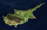
, an island country situated in the Eastern Basin of the Mediterranean Sea
. Cyprus is third largest island
in the Mediterranean (after the Italian
islands of Sicily
and Sardinia
) and the world's 81st largest. It is located south of Asia Minor, the Anatolia
n peninsula
of the Asia
n (or Eurasia
n) mainland (now part of modern-day Turkey
), so it may be included in Western Asia
or the Middle East
: At a confluence of Western Asia, Southern Europe
, and Northern Africa, Cyprus has had lengthy periods of mainly Greek
and intermittent Anatolian, Levant
ine, Byzantine
, and Western Europe
an influences. It is sometimes included in Europe
, and has been a member state of the European Union
since 1 May 2004.
Cyprus measures 240 kilometres latitudinally
and 100 km (62 mi) longitudinally, with Turkey 75 km (47 mi) to the north. Other neighbouring territories include Syria
and Lebanon
to the east (105 km and 108 km (67 mi), respectively), Israel
200 km (124 mi) to the southeast, Egypt
380 km (236 mi) to the south, and Greece
to the west-northwest: 280 km (174 mi) to the small Dodecanesian
island of Kastellórizo (Meyísti), 400 km (249 mi) to Rhodes
, and 800 km (497 mi) to the Greek mainland.
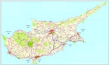
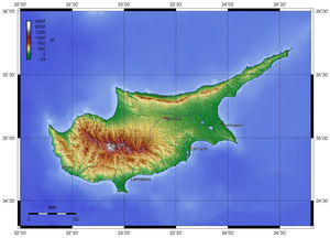
The island is dominated by two mountain ranges, the Troodos Mountains and the Kyrenia Mountains, and the central plain, the Mesaoria
, which is between them. The Troodos Mountains
cover most of the southern and western portions of the island and account for roughly half its area. The narrow Kyrenia Range, extends along the northern coastline. It is not as high as the Troodos Mountains, and it occupies substantially less area. The two mountain ranges run generally parallel to the Taurus Mountains
on the Turkish mainland, the outlines of which are visible from northern Cyprus. Coastal lowlands, varying in width, surround the island.
Geopolitically
, the island is divided into four main segments. The Republic of Cyprus, the internationally recognized government, occupies the southern two-thirds of the island. Turkey occupies the northern third of the island which it calls the Turkish Republic of Northern Cyprus; a de facto independent state recognised only by Turkey. The United Nations
-controlled Green Line is a buffer zone that separates the two. Lastly, two bases under British sovereignty
, Akrotiri and Dhekelia
, are located on the island.
 The rugged Troodos Mountains
, whose principal range stretches from Pomos Point in the northwest almost to Larnaca Bay on the east, are the single most conspicuous feature of the landscape. Intensive uplifting and folding in the formative period left the area highly fragmented, so that subordinate ranges and spurs veer off at many angles, their slopes incised by steep-sided valleys. In the southwest, the mountains descend in a series of stepped foothills to the coastal plain.
While the Troodos Mountains are a massif formed of molten igneous rock, the Kyrenia Range is a narrow limestone ridge that rises suddenly from the plains. Its easternmost extension becomes a series of foothills on the Karpass Peninsula
. That peninsula points toward Asia Minor, to which Cyprus belongs geologically.
Even the highest peaks of the Kyrenia Range are hardly more than half the height of the great dome of the Troodos massif, Mount Olympus
(1952 m (6,404 ft)), but their seemingly inaccessible, jagged slopes make them considerably more spectacular. British
writer Lawrence Durrell
, in Bitter Lemons, wrote of the Troodos as "an unlovely jumble of crags and heavyweight rocks" and of the Kyrenia Range as belonging to "the world of Gothic
Europe
, its lofty crags studded with crusader castles."
Rich copper deposits were discovered in antiquity on the slopes of the Troodos. The massive sulfide deposits formed as a part of an ophiolite complex at a spreading center
under the Mediterranean Sea which was tectonically
uplifted during the Pleistocene
and emplaced in its current location.
flow eastward across the Mesaoria into Famagusta Bay; the Serraghis River flows northwest through the Morphou plain. All of the island's rivers, however, are dry in the summer. An extensive system of dams and waterways has been constructed to bring water to farming areas.
The Mesaoria is the agricultural heartland of the island, but its productiveness for wheat and barley depends very much on winter rainfall; other crops are grown under irrigation. Little evidence remains that this broad, central plain, open to the sea at either end, was once covered with rich forests whose timber was coveted by ancient conquerors for their sailing vessels. The now-divided capital of the island, Nicosia, lies in the middle of this central plain.
es and oak
s. Ancient authors write that most of Cyprus, even Messaoria, was heavily forested, and there are still considerable forests on the Troodos and Kyrenia ranges, and locally at lower altitudes. About 17% of the whole island is classified as woodland. Where there is no forest, tall shrub communities of golden oak
(Quercus alnifolia), strawberry tree (Arbutus andrachne
), terebinth (Pistacia terebinthus), olive (Olea europaea), kermes oak (Quercus coccifera) and styrax (Styrax officinalis
) are found, but such maquis
is uncommon. Over most of the island untilled ground bears a grazed covering of garrigue
, largely composed of low bushes of Cistus
, Genista sphacelata, Calycotoime villosa, Lithospermum hispidulum, Phaganalon rupestre and, locally, Pistacia lentiscus. Where grazing is excessive this covering is soon reduced, and an impoverished batha
remains, consisting principally of Thymus capitatus
, Sarcopoterium spinosum, and a few stunted herbs.
, warm and rather dry, with rainfall mainly between November and March, favors agriculture. In general, the island experiences mild wet winters and dry hot summers. Variations in temperature and rainfall are governed by altitude and, to a lesser extent, distance from the coast. Hot, dry summers from mid-May to mid-September and rainy, rather changeable winters from November to mid-March are separated by short autumn and spring seasons.
total:
9,251 km² (of which 3355 km² (1,295 sq mi) are under the administration of the de facto Turkish Republic of Northern Cyprus
)
land:
9,240 km²
water:
10 km²
Area - comparative:
about 0.6 times the size of Connecticut
or 0.7 times the size of Northern Ireland
Land boundaries:
0 km
Coastline:
648 km
Maritime claims:
continental shelf:
200 m depth or to the depth of exploitation
territorial sea:
12 nmi (22.2 km; 13.8 mi)
Elevation extremes:
lowest point:
Mediterranean Sea 0 m
highest point:
Olympus 1,952 m
copper
, pyrites, asbestos
, gypsum
, timber
, salt
, marble
, clay earth pigment
Land use:
arable land:
12%
permanent crops:
5%
permanent pastures:
0%
forests and woodland:
13%
other:
70% (1993 est.)
Irrigated land:
400 km² (1999 UN est.)
moderate earthquake
activity
Environment - current issues:
water
resource problems (no natural reservoir catchments, seasonal disparity in rainfall, sea water intrusion
to island's largest aquifer
, increased salination
in the north); water pollution from sewage and industrial wastes; coastal degradation; loss of wildlife habitats from urbanization
Environment - international agreements:
party to:
Air Pollution, Biodiversity, Climate Change, Climate Change-Kyoto Protocol
, Endangered Species, Environmental Modification, Hazardous Wastes, Law of the Sea, Marine Dumping, Nuclear Test Ban, Ozone Layer Protection, Ship Pollution
signed, but not ratified:
Air Pollution-Persistent Organic Pollutants
Physical geography
Physical geography is one of the two major subfields of geography. Physical geography is that branch of natural science which deals with the study of processes and patterns in the natural environment like the atmosphere, biosphere and geosphere, as opposed to the cultural or built environment, the...
and human geography
Human geography
Human geography is one of the two major sub-fields of the discipline of geography. Human geography is the study of the world, its people, communities, and cultures. Human geography differs from physical geography mainly in that it has a greater focus on studying human activities and is more...
of Cyprus
Cyprus
Cyprus , officially the Republic of Cyprus , is a Eurasian island country, member of the European Union, in the Eastern Mediterranean, east of Greece, south of Turkey, west of Syria and north of Egypt. It is the third largest island in the Mediterranean Sea.The earliest known human activity on the...
, an island country situated in the Eastern Basin of the Mediterranean Sea
Mediterranean Sea
The Mediterranean Sea is a sea connected to the Atlantic Ocean surrounded by the Mediterranean region and almost completely enclosed by land: on the north by Anatolia and Europe, on the south by North Africa, and on the east by the Levant...
. Cyprus is third largest island
Island
An island or isle is any piece of sub-continental land that is surrounded by water. Very small islands such as emergent land features on atolls can be called islets, cays or keys. An island in a river or lake may be called an eyot , or holm...
in the Mediterranean (after the Italian
Italy
Italy , officially the Italian Republic languages]] under the European Charter for Regional or Minority Languages. In each of these, Italy's official name is as follows:;;;;;;;;), is a unitary parliamentary republic in South-Central Europe. To the north it borders France, Switzerland, Austria and...
islands of Sicily
Sicily
Sicily is a region of Italy, and is the largest island in the Mediterranean Sea. Along with the surrounding minor islands, it constitutes an autonomous region of Italy, the Regione Autonoma Siciliana Sicily has a rich and unique culture, especially with regard to the arts, music, literature,...
and Sardinia
Sardinia
Sardinia is the second-largest island in the Mediterranean Sea . It is an autonomous region of Italy, and the nearest land masses are the French island of Corsica, the Italian Peninsula, Sicily, Tunisia and the Spanish Balearic Islands.The name Sardinia is from the pre-Roman noun *sard[],...
) and the world's 81st largest. It is located south of Asia Minor, the Anatolia
Anatolia
Anatolia is a geographic and historical term denoting the westernmost protrusion of Asia, comprising the majority of the Republic of Turkey...
n peninsula
Peninsula
A peninsula is a piece of land that is bordered by water on three sides but connected to mainland. In many Germanic and Celtic languages and also in Baltic, Slavic and Hungarian, peninsulas are called "half-islands"....
of the Asia
Asia
Asia is the world's largest and most populous continent, located primarily in the eastern and northern hemispheres. It covers 8.7% of the Earth's total surface area and with approximately 3.879 billion people, it hosts 60% of the world's current human population...
n (or Eurasia
Eurasia
Eurasia is a continent or supercontinent comprising the traditional continents of Europe and Asia ; covering about 52,990,000 km2 or about 10.6% of the Earth's surface located primarily in the eastern and northern hemispheres...
n) mainland (now part of modern-day Turkey
Turkey
Turkey , known officially as the Republic of Turkey , is a Eurasian country located in Western Asia and in East Thrace in Southeastern Europe...
), so it may be included in Western Asia
Southwest Asia
Western Asia, West Asia, Southwest Asia or Southwestern Asia are terms that describe the westernmost portion of Asia. The terms are partly coterminous with the Middle East, which describes a geographical position in relation to Western Europe rather than its location within Asia...
or the Middle East
Middle East
The Middle East is a region that encompasses Western Asia and Northern Africa. It is often used as a synonym for Near East, in opposition to Far East...
: At a confluence of Western Asia, Southern Europe
Southern Europe
The term Southern Europe, at its most general definition, is used to mean "all countries in the south of Europe". However, the concept, at different times, has had different meanings, providing additional political, linguistic and cultural context to the definition in addition to the typical...
, and Northern Africa, Cyprus has had lengthy periods of mainly Greek
Greece
Greece , officially the Hellenic Republic , and historically Hellas or the Republic of Greece in English, is a country in southeastern Europe....
and intermittent Anatolian, Levant
Levant
The Levant or ) is the geographic region and culture zone of the "eastern Mediterranean littoral between Anatolia and Egypt" . The Levant includes most of modern Lebanon, Syria, Jordan, Israel, the Palestinian territories, and sometimes parts of Turkey and Iraq, and corresponds roughly to the...
ine, Byzantine
Byzantine Empire
The Byzantine Empire was the Eastern Roman Empire during the periods of Late Antiquity and the Middle Ages, centred on the capital of Constantinople. Known simply as the Roman Empire or Romania to its inhabitants and neighbours, the Empire was the direct continuation of the Ancient Roman State...
, and Western Europe
Western Europe
Western Europe is a loose term for the collection of countries in the western most region of the European continents, though this definition is context-dependent and carries cultural and political connotations. One definition describes Western Europe as a geographic entity—the region lying in the...
an influences. It is sometimes included in Europe
Europe
Europe is, by convention, one of the world's seven continents. Comprising the westernmost peninsula of Eurasia, Europe is generally 'divided' from Asia to its east by the watershed divides of the Ural and Caucasus Mountains, the Ural River, the Caspian and Black Seas, and the waterways connecting...
, and has been a member state of the European Union
Member State of the European Union
A member state of the European Union is a state that is party to treaties of the European Union and has thereby undertaken the privileges and obligations that EU membership entails. Unlike membership of an international organisation, being an EU member state places a country under binding laws in...
since 1 May 2004.
Cyprus measures 240 kilometres latitudinally
Transversality
In mathematics, transversality is a notion that describes how spaces can intersect; transversality can be seen as the "opposite" of tangency, and plays a role in general position. It formalizes the idea of a generic intersection in differential topology...
and 100 km (62 mi) longitudinally, with Turkey 75 km (47 mi) to the north. Other neighbouring territories include Syria
Syria
Syria , officially the Syrian Arab Republic , is a country in Western Asia, bordering Lebanon and the Mediterranean Sea to the West, Turkey to the north, Iraq to the east, Jordan to the south, and Israel to the southwest....
and Lebanon
Lebanon
Lebanon , officially the Republic of LebanonRepublic of Lebanon is the most common term used by Lebanese government agencies. The term Lebanese Republic, a literal translation of the official Arabic and French names that is not used in today's world. Arabic is the most common language spoken among...
to the east (105 km and 108 km (67 mi), respectively), Israel
Israel
The State of Israel is a parliamentary republic located in the Middle East, along the eastern shore of the Mediterranean Sea...
200 km (124 mi) to the southeast, Egypt
Egypt
Egypt , officially the Arab Republic of Egypt, Arabic: , is a country mainly in North Africa, with the Sinai Peninsula forming a land bridge in Southwest Asia. Egypt is thus a transcontinental country, and a major power in Africa, the Mediterranean Basin, the Middle East and the Muslim world...
380 km (236 mi) to the south, and Greece
Greece
Greece , officially the Hellenic Republic , and historically Hellas or the Republic of Greece in English, is a country in southeastern Europe....
to the west-northwest: 280 km (174 mi) to the small Dodecanesian
Dodecanese
The Dodecanese are a group of 12 larger plus 150 smaller Greek islands in the Aegean Sea, of which 26 are inhabited. Τhis island group generally defines the eastern limit of the Sea of Crete. They belong to the Southern Sporades island group...
island of Kastellórizo (Meyísti), 400 km (249 mi) to Rhodes
Rhodes
Rhodes is an island in Greece, located in the eastern Aegean Sea. It is the largest of the Dodecanese islands in terms of both land area and population, with a population of 117,007, and also the island group's historical capital. Administratively the island forms a separate municipality within...
, and 800 km (497 mi) to the Greek mainland.
The island is dominated by two mountain ranges, the Troodos Mountains and the Kyrenia Mountains, and the central plain, the Mesaoria
Mesaoria
The Mesaoria is a broad, sweeping plain which makes up the centre of the island of Cyprus.-Geography:The Mesaoria plain is bounded on the east and west by the Mediterranean Sea, on the south by the Troodos mountains and on the north by the Kyrenia mountains. It has an area of approximately...
, which is between them. The Troodos Mountains
Troodos Mountains
Troodos is the biggest mountain range of Cyprus, located in the center of the island. Troodos' highest peak is Mount Olympus at 1,952 metres.The Troodos mountain range stretches across most of the western side of Cyprus...
cover most of the southern and western portions of the island and account for roughly half its area. The narrow Kyrenia Range, extends along the northern coastline. It is not as high as the Troodos Mountains, and it occupies substantially less area. The two mountain ranges run generally parallel to the Taurus Mountains
Taurus Mountains
Taurus Mountains are a mountain complex in southern Turkey, dividing the Mediterranean coastal region of southern Turkey from the central Anatolian Plateau. The system extends along a curve from Lake Eğirdir in the west to the upper reaches of the Euphrates and Tigris rivers in the east...
on the Turkish mainland, the outlines of which are visible from northern Cyprus. Coastal lowlands, varying in width, surround the island.
Geopolitically
Geopolitics
Geopolitics, from Greek Γη and Πολιτική in broad terms, is a theory that describes the relation between politics and territory whether on local or international scale....
, the island is divided into four main segments. The Republic of Cyprus, the internationally recognized government, occupies the southern two-thirds of the island. Turkey occupies the northern third of the island which it calls the Turkish Republic of Northern Cyprus; a de facto independent state recognised only by Turkey. The United Nations
United Nations
The United Nations is an international organization whose stated aims are facilitating cooperation in international law, international security, economic development, social progress, human rights, and achievement of world peace...
-controlled Green Line is a buffer zone that separates the two. Lastly, two bases under British sovereignty
Sovereign Base Areas
The Sovereign Base Areas are military bases located on territory in which the United Kingdom is sovereign, but which are separated from the ordinary British territory....
, Akrotiri and Dhekelia
Akrotiri and Dhekelia
The Sovereign Base Areas of Akrotiri and Dhekelia are two British-administered areas comprising a British Overseas Territory on the island of Cyprus administered as Sovereign Base Areas of the United Kingdom...
, are located on the island.
Terrain
Troodos Mountains
Troodos is the biggest mountain range of Cyprus, located in the center of the island. Troodos' highest peak is Mount Olympus at 1,952 metres.The Troodos mountain range stretches across most of the western side of Cyprus...
, whose principal range stretches from Pomos Point in the northwest almost to Larnaca Bay on the east, are the single most conspicuous feature of the landscape. Intensive uplifting and folding in the formative period left the area highly fragmented, so that subordinate ranges and spurs veer off at many angles, their slopes incised by steep-sided valleys. In the southwest, the mountains descend in a series of stepped foothills to the coastal plain.
While the Troodos Mountains are a massif formed of molten igneous rock, the Kyrenia Range is a narrow limestone ridge that rises suddenly from the plains. Its easternmost extension becomes a series of foothills on the Karpass Peninsula
Karpass Peninsula
The Karpass Peninsula , also known as Karpasia or Kırpaşa is a long, finger-like peninsula that is one of the most prominent geographical features of the island of Cyprus. Its farthest extent is Cape Apostolos Andreas, and its major population centre is the town of Rizokarpaso...
. That peninsula points toward Asia Minor, to which Cyprus belongs geologically.
Even the highest peaks of the Kyrenia Range are hardly more than half the height of the great dome of the Troodos massif, Mount Olympus
Mount Olympus (Cyprus)
Olympus, or Chionistra, at , is the highest point in Cyprus. It is located in the Troodos Mountains of Cyprus. A British long range radar currently operates at Mount Olympus' peak....
(1952 m (6,404 ft)), but their seemingly inaccessible, jagged slopes make them considerably more spectacular. British
United Kingdom
The United Kingdom of Great Britain and Northern IrelandIn the United Kingdom and Dependencies, other languages have been officially recognised as legitimate autochthonous languages under the European Charter for Regional or Minority Languages...
writer Lawrence Durrell
Lawrence Durrell
Lawrence George Durrell was an expatriate British novelist, poet, dramatist, and travel writer, though he resisted affiliation with Britain and preferred to be considered cosmopolitan...
, in Bitter Lemons, wrote of the Troodos as "an unlovely jumble of crags and heavyweight rocks" and of the Kyrenia Range as belonging to "the world of Gothic
Gothic art
Gothic art was a Medieval art movement that developed in France out of Romanesque art in the mid-12th century, led by the concurrent development of Gothic architecture. It spread to all of Western Europe, but took over art more completely north of the Alps, never quite effacing more classical...
Europe
Europe
Europe is, by convention, one of the world's seven continents. Comprising the westernmost peninsula of Eurasia, Europe is generally 'divided' from Asia to its east by the watershed divides of the Ural and Caucasus Mountains, the Ural River, the Caspian and Black Seas, and the waterways connecting...
, its lofty crags studded with crusader castles."
Rich copper deposits were discovered in antiquity on the slopes of the Troodos. The massive sulfide deposits formed as a part of an ophiolite complex at a spreading center
Mid-ocean ridge
A mid-ocean ridge is a general term for an underwater mountain system that consists of various mountain ranges , typically having a valley known as a rift running along its spine, formed by plate tectonics. This type of oceanic ridge is characteristic of what is known as an oceanic spreading...
under the Mediterranean Sea which was tectonically
Tectonics
Tectonics is a field of study within geology concerned generally with the structures within the lithosphere of the Earth and particularly with the forces and movements that have operated in a region to create these structures.Tectonics is concerned with the orogenies and tectonic development of...
uplifted during the Pleistocene
Pleistocene
The Pleistocene is the epoch from 2,588,000 to 11,700 years BP that spans the world's recent period of repeated glaciations. The name pleistocene is derived from the Greek and ....
and emplaced in its current location.
Drainage
In much of the island, access to a year-round supply of water is difficult. This is traditionally attributed to deforestation which damaged the island's drainage system through erosion, but Grove and Rackham question this view. A network of winter rivers rises in the Troodos Mountains and flows out from them in all directions. The Yialias River and the Pedhieos RiverPedieos
The Pedieos is the longest river in Cyprus. The river originates in the Troodos Mountains close to Machairas Monastery and flows northeast across the Mesaoria plains, through the capital city Nicosia...
flow eastward across the Mesaoria into Famagusta Bay; the Serraghis River flows northwest through the Morphou plain. All of the island's rivers, however, are dry in the summer. An extensive system of dams and waterways has been constructed to bring water to farming areas.
The Mesaoria is the agricultural heartland of the island, but its productiveness for wheat and barley depends very much on winter rainfall; other crops are grown under irrigation. Little evidence remains that this broad, central plain, open to the sea at either end, was once covered with rich forests whose timber was coveted by ancient conquerors for their sailing vessels. The now-divided capital of the island, Nicosia, lies in the middle of this central plain.
Natural vegetation
Despite its small size, Cyprus has a variety of natural vegetation. This includes forests of conifers and broadleaved trees such as Pinus brutia, cedar, cypressCypress
Cypress is the name applied to many plants in the cypress family Cupressaceae, which is a conifer of northern temperate regions. Most cypress species are trees, while a few are shrubs...
es and oak
Oak
An oak is a tree or shrub in the genus Quercus , of which about 600 species exist. "Oak" may also appear in the names of species in related genera, notably Lithocarpus...
s. Ancient authors write that most of Cyprus, even Messaoria, was heavily forested, and there are still considerable forests on the Troodos and Kyrenia ranges, and locally at lower altitudes. About 17% of the whole island is classified as woodland. Where there is no forest, tall shrub communities of golden oak
Golden Oak
Quercus alnifolia, the golden oak, is an evergreen oak species of Cyprus. Its common English name refers to the golden coloured lower surface of its leaves. Quercus alnifolia belongs to the endemic flora of the island and it is confined to the igneous geological complex of the Troodos Mountains...
(Quercus alnifolia), strawberry tree (Arbutus andrachne
Arbutus andrachne
Arbutus andrachne, commonly called the Greek Strawberry Tree, is an evergreen shrub or small tree in the family Ericaceae, native to the Mediterranean region, the Middle East, and southwestern Asia.-Garden history:...
), terebinth (Pistacia terebinthus), olive (Olea europaea), kermes oak (Quercus coccifera) and styrax (Styrax officinalis
Styrax officinalis
Styrax offinalis is a shrub native to southern Europe and the Middle East. The same species is considered to occur native to California . The California varieties Styrax officinalis subsp. redidivus H. Howard and Styrax officinalis subsp...
) are found, but such maquis
Maquis shrubland
thumb|220px|Low Maquis in Corsica.220px|thumb|High macchia in Sardinia.Maquis or macchia is a shrubland biome in the Mediterranean region, typically consisting of densely growing evergreen shrubs such as holm oak, tree heath, strawberry tree, sage, juniper, buckthorn, spurge olive and myrtle...
is uncommon. Over most of the island untilled ground bears a grazed covering of garrigue
Garrigue
Garrigue or phrygana is a type of low, soft-leaved scrubland ecoregion and plant community in the Mediterranean forests, woodlands, and scrub biome. It is found on limestone soils around the Mediterranean Basin, generally near the seacoast, where the climate is ameliorated, but where annual summer...
, largely composed of low bushes of Cistus
Cistus
Cistus is a genus of flowering plants in the rockrose family Cistaceae, containing about 20 species . They are perennial shrubs found on dry or rocky soils throughout the Mediterranean region, from Morocco and Portugal through to the Middle East, and also on the Canary Islands...
, Genista sphacelata, Calycotoime villosa, Lithospermum hispidulum, Phaganalon rupestre and, locally, Pistacia lentiscus. Where grazing is excessive this covering is soon reduced, and an impoverished batha
Garrigue
Garrigue or phrygana is a type of low, soft-leaved scrubland ecoregion and plant community in the Mediterranean forests, woodlands, and scrub biome. It is found on limestone soils around the Mediterranean Basin, generally near the seacoast, where the climate is ameliorated, but where annual summer...
remains, consisting principally of Thymus capitatus
Thymus capitatus
Thymus capitatus is a compact, woody perennial native to Mediterranean Europe and Turkey.The plant has with rising stems and narrow, fleshy, oil-gland-dotted, green leaves to long....
, Sarcopoterium spinosum, and a few stunted herbs.
Climate
The Mediterranean climateMediterranean climate
A Mediterranean climate is the climate typical of most of the lands in the Mediterranean Basin, and is a particular variety of subtropical climate...
, warm and rather dry, with rainfall mainly between November and March, favors agriculture. In general, the island experiences mild wet winters and dry hot summers. Variations in temperature and rainfall are governed by altitude and, to a lesser extent, distance from the coast. Hot, dry summers from mid-May to mid-September and rainy, rather changeable winters from November to mid-March are separated by short autumn and spring seasons.
Area and boundaries
Area:total:
9,251 km² (of which 3355 km² (1,295 sq mi) are under the administration of the de facto Turkish Republic of Northern Cyprus
Turkish Republic of Northern Cyprus
Northern Cyprus or North Cyprus , officially the Turkish Republic of Northern Cyprus , is a self-declared state that comprises the northeastern part of the island of Cyprus...
)
land:
9,240 km²
water:
10 km²
Area - comparative:
about 0.6 times the size of Connecticut
Connecticut
Connecticut is a state in the New England region of the northeastern United States. It is bordered by Rhode Island to the east, Massachusetts to the north, and the state of New York to the west and the south .Connecticut is named for the Connecticut River, the major U.S. river that approximately...
or 0.7 times the size of Northern Ireland
Northern Ireland
Northern Ireland is one of the four countries of the United Kingdom. Situated in the north-east of the island of Ireland, it shares a border with the Republic of Ireland to the south and west...
Land boundaries:
0 km
Coastline:
648 km
Maritime claims:
continental shelf:
200 m depth or to the depth of exploitation
territorial sea:
12 nmi (22.2 km; 13.8 mi)
Elevation extremes:
lowest point:
Mediterranean Sea 0 m
highest point:
Olympus 1,952 m
Resource and land use
Natural resources:copper
Copper
Copper is a chemical element with the symbol Cu and atomic number 29. It is a ductile metal with very high thermal and electrical conductivity. Pure copper is soft and malleable; an exposed surface has a reddish-orange tarnish...
, pyrites, asbestos
Asbestos
Asbestos is a set of six naturally occurring silicate minerals used commercially for their desirable physical properties. They all have in common their eponymous, asbestiform habit: long, thin fibrous crystals...
, gypsum
Gypsum
Gypsum is a very soft sulfate mineral composed of calcium sulfate dihydrate, with the chemical formula CaSO4·2H2O. It is found in alabaster, a decorative stone used in Ancient Egypt. It is the second softest mineral on the Mohs Hardness Scale...
, timber
Timber
Timber may refer to:* Timber, a term common in the United Kingdom and Australia for wood materials * Timber, Oregon, an unincorporated community in the U.S...
, salt
Salt
In chemistry, salts are ionic compounds that result from the neutralization reaction of an acid and a base. They are composed of cations and anions so that the product is electrically neutral...
, marble
Marble
Marble is a metamorphic rock composed of recrystallized carbonate minerals, most commonly calcite or dolomite.Geologists use the term "marble" to refer to metamorphosed limestone; however stonemasons use the term more broadly to encompass unmetamorphosed limestone.Marble is commonly used for...
, clay earth pigment
Clay earth pigment
Clay earth pigments are naturally occurring minerals, principally iron oxides, that have been used since prehistoric times as pigments. The primary types are*ochre*sienna*umber...
Land use:
arable land:
12%
permanent crops:
5%
permanent pastures:
0%
forests and woodland:
13%
other:
70% (1993 est.)
Irrigated land:
400 km² (1999 UN est.)
Environmental concerns
Natural hazards:moderate earthquake
Earthquake
An earthquake is the result of a sudden release of energy in the Earth's crust that creates seismic waves. The seismicity, seismism or seismic activity of an area refers to the frequency, type and size of earthquakes experienced over a period of time...
activity
Environment - current issues:
water
Water
Water is a chemical substance with the chemical formula H2O. A water molecule contains one oxygen and two hydrogen atoms connected by covalent bonds. Water is a liquid at ambient conditions, but it often co-exists on Earth with its solid state, ice, and gaseous state . Water also exists in a...
resource problems (no natural reservoir catchments, seasonal disparity in rainfall, sea water intrusion
Saltwater intrusion
Saltwater intrusion is the movement of saline water into freshwater aquifers. Most often, it is caused by ground-water pumping from coastal wells, or from construction of navigation channels or oil field canals. The channels and canals provide conduits for salt water to be brought into fresh...
to island's largest aquifer
Aquifer
An aquifer is a wet underground layer of water-bearing permeable rock or unconsolidated materials from which groundwater can be usefully extracted using a water well. The study of water flow in aquifers and the characterization of aquifers is called hydrogeology...
, increased salination
Soil salination
Soil salinity is the salt content in the soil.- Causes of soil salinity :Salt-affected soils are caused by excess accumulation of salts, typically most pronounced at the soil surface. Salts can be transported to the soil surface by capillary transport from a salt laden water table and then...
in the north); water pollution from sewage and industrial wastes; coastal degradation; loss of wildlife habitats from urbanization
Environment - international agreements:
party to:
Air Pollution, Biodiversity, Climate Change, Climate Change-Kyoto Protocol
Kyoto Protocol
The Kyoto Protocol is a protocol to the United Nations Framework Convention on Climate Change , aimed at fighting global warming...
, Endangered Species, Environmental Modification, Hazardous Wastes, Law of the Sea, Marine Dumping, Nuclear Test Ban, Ozone Layer Protection, Ship Pollution
signed, but not ratified:
Air Pollution-Persistent Organic Pollutants