

Drought in the United States
Encyclopedia

Precipitation (meteorology)
In meteorology, precipitation In meteorology, precipitation In meteorology, precipitation (also known as one of the classes of hydrometeors, which are atmospheric water phenomena is any product of the condensation of atmospheric water vapor that falls under gravity. The main forms of precipitation...
leads to drought
Drought
A drought is an extended period of months or years when a region notes a deficiency in its water supply. Generally, this occurs when a region receives consistently below average precipitation. It can have a substantial impact on the ecosystem and agriculture of the affected region...
, which is caused by an above average persistence of high pressure over the drought area. Changes in the track of extratropical cyclone
Extratropical cyclone
Extratropical cyclones, sometimes called mid-latitude cyclones or wave cyclones, are a group of cyclones defined as synoptic scale low pressure weather systems that occur in the middle latitudes of the Earth having neither tropical nor polar characteristics, and are connected with fronts and...
s, which can occur during climate
Climate
Climate encompasses the statistics of temperature, humidity, atmospheric pressure, wind, rainfall, atmospheric particle count and other meteorological elemental measurements in a given region over long periods...
cycles such as the El Niño-Southern Oscillation
El Niño-Southern Oscillation
El Niño/La Niña-Southern Oscillation, or ENSO, is a quasiperiodic climate pattern that occurs across the tropical Pacific Ocean roughly every five years...
, or ENSO, as well as the North Atlantic Oscillation
North Atlantic oscillation
The North Atlantic oscillation is a climatic phenomenon in the North Atlantic Ocean of fluctuations in the difference of atmospheric pressure at sea level between the Icelandic low and the Azores high. Through east-west oscillation motions of the Icelandic low and the Azores high, it controls the...
, Pacific Decadal Oscillation
Pacific decadal oscillation
The Pacific Decadal Oscillation is a pattern of Pacific climate variability that shifts phases on at least inter-decadal time scale, usually about 20 to 30 years. The PDO is detected as warm or cool surface waters in the Pacific Ocean, north of 20° N...
, and Atlantic Multidecadal Oscillation
Atlantic Multidecadal Oscillation
The Atlantic multidecadal oscillation is a mode of variability occurring in the North Atlantic Ocean and which has its principal expression in the sea surface temperature field...
, modulates which areas would be more prone to drought and when drought develops. Warming climates are expected to increase drought frequency due to increased evaporation
Evaporation
Evaporation is a type of vaporization of a liquid that occurs only on the surface of a liquid. The other type of vaporization is boiling, which, instead, occurs on the entire mass of the liquid....
. In dry areas, removing grass
Grass
Grasses, or more technically graminoids, are monocotyledonous, usually herbaceous plants with narrow leaves growing from the base. They include the "true grasses", of the Poaceae family, as well as the sedges and the rushes . The true grasses include cereals, bamboo and the grasses of lawns ...
cover and going with a more natural vegetation for the area can reduce the impact of drought, since a significant amount of fresh water
Freshwater
Fresh water is naturally occurring water on the Earth's surface in ice sheets, ice caps, glaciers, bogs, ponds, lakes, rivers and streams, and underground as groundwater in aquifers and underground streams. Fresh water is generally characterized by having low concentrations of dissolved salts and...
is used to keep lawns green. Droughts are periodic, alternating with floods over a series of years. The worst droughts in the history of the United States
United States
The United States of America is a federal constitutional republic comprising fifty states and a federal district...
occurred during the 1930s and 1950s, periods of time known as Dust Bowl years.
Causes
Generally, rain
Rain
Rain is liquid precipitation, as opposed to non-liquid kinds of precipitation such as snow, hail and sleet. Rain requires the presence of a thick layer of the atmosphere to have temperatures above the melting point of water near and above the Earth's surface...
fall is related to the amount of water vapour in the Earth's atmosphere
Earth's atmosphere
The atmosphere of Earth is a layer of gases surrounding the planet Earth that is retained by Earth's gravity. The atmosphere protects life on Earth by absorbing ultraviolet solar radiation, warming the surface through heat retention , and reducing temperature extremes between day and night...
, combined with the upward forcing of the air mass containing that water vapor. If either moisture, lift, or atmospheric instability are reduced, rain will be more scant which in time will lead to drought. This can be triggered by an above average prevalence of high pressure system
Pressure system
A pressure system is a region of the Earth's atmosphere where air pressure is a relative peak or lull in the sea level pressure distribution. The surface pressure at sea level varies minimally, with the lowest value measured and the highest recorded...
s, wind
Wind
Wind is the flow of gases on a large scale. On Earth, wind consists of the bulk movement of air. In outer space, solar wind is the movement of gases or charged particles from the sun through space, while planetary wind is the outgassing of light chemical elements from a planet's atmosphere into space...
s carrying continental, rather than oceanic air masses (i.e. reduced water content), and ridges of high pressure area
High pressure area
A high-pressure area is a region where the atmospheric pressure at the surface of the planet is greater than its surrounding environment. Winds within high-pressure areas flow outward due to the higher density air near their center and friction with land...
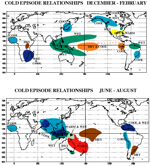
s form with behaviors which prevent or restrict the developing of thunderstorm activity or rainfall over one certain region. Oceanic and atmospheric weather cycles such as ENSO make drought a regular recurring feature of the Americas along the Pacific coast. Droughts can develop anywhere in the United States. El Nino and La Nina
La Niña
La Niña is a coupled ocean-atmosphere phenomenon that is the counterpart of El Niño as part of the broader El Niño-Southern Oscillation climate pattern. During a period of La Niña, the sea surface temperature across the equatorial Eastern Central Pacific Ocean will be lower than normal by 3–5 °C...
alters rainfall patterns in the West and along the Gulf coast. The North Atlantic Oscillation, Atlantic Multidecadal Oscillation (AMO), and Pacific Decadal Oscillation (PDO) are also significantly tied to droughts in the United States. For example, 52 percent of drought timing and location across the United States is explained by the PDO and AMO. When both in their positive phase, the most extensive droughts occur across the United States.
Human activity can directly trigger exacerbating factors such as over farming, excessive irrigation, deforestation
Deforestation
Deforestation is the removal of a forest or stand of trees where the land is thereafter converted to a nonforest use. Examples of deforestation include conversion of forestland to farms, ranches, or urban use....
, and erosion
Erosion
Erosion is when materials are removed from the surface and changed into something else. It only works by hydraulic actions and transport of solids in the natural environment, and leads to the deposition of these materials elsewhere...
adversely impact the ability of the land to capture and hold water. While these tend to be relatively isolated in their scope, activities resulting in global climate change
Climate change
Climate change is a significant and lasting change in the statistical distribution of weather patterns over periods ranging from decades to millions of years. It may be a change in average weather conditions or the distribution of events around that average...
are expected to trigger droughts with a substantial impact on agriculture
Climate change and agriculture
Climate change and agriculture are interrelated processes, both of which take place on a global scale. Global warming is projected to have significant impacts on conditions affecting agriculture, including temperature, carbon dioxide, glacial run-off, precipitation and the interaction of these...
throughout the world, and especially in developing nations. Although global warming will result in increased world rainfall, warmer temperatures also bring increased evaporation and increased drought frequency. Along with drought in some areas, flooding and erosion will increase in others. Some proposed solutions to global warming
Mitigation of global warming
Climate change mitigation is action to decrease the intensity of radiative forcing in order to reduce the potential effects of global warming. Mitigation is distinguished from adaptation to global warming, which involves acting to tolerate the effects of global warming...
that focus on more active techniques, solar radiation management
Solar radiation management
Solar radiation management projects are a type of geoengineering which seek to reflect sunlight and thus reduce global warming. Examples include the creation of stratospheric sulfur aerosols. They do not reduce greenhouse gas concentrations in the atmosphere, and thus do not address problems...
through the use of a space sunshade for one, may also carry with them increased chances of drought.
Response
Certain regions within the United States are more susceptible to droughts than others. Droughts can be more damaging than tornadoes, tropical cyclones, winter storms and flooding combined. Unlike a hurricane, tornado or flooding, the onset of droughts happen gradually over a long period of time.In the Nevada
Nevada
Nevada is a state in the western, mountain west, and southwestern regions of the United States. With an area of and a population of about 2.7 million, it is the 7th-largest and 35th-most populous state. Over two-thirds of Nevada's people live in the Las Vegas metropolitan area, which contains its...
"cash for grass" program, the people are paid to remove grass
Grass
Grasses, or more technically graminoids, are monocotyledonous, usually herbaceous plants with narrow leaves growing from the base. They include the "true grasses", of the Poaceae family, as well as the sedges and the rushes . The true grasses include cereals, bamboo and the grasses of lawns ...
and put in desert
Desert
A desert is a landscape or region that receives an extremely low amount of precipitation, less than enough to support growth of most plants. Most deserts have an average annual precipitation of less than...
landscaping
Landscaping
Landscaping refers to any activity that modifies the visible features of an area of land, including:# living elements, such as flora or fauna; or what is commonly referred to as gardening, the art and craft of growing plants with a goal of creating a beautiful environment within the landscape.#...
. Xeriscaping
Xeriscaping
Xeriscaping and xerogardening refers to landscaping and gardening in ways that reduce or eliminate the need for supplemental water from irrigation...
calls for the planting of vegetation which is local in origin and more resistant to drought.
When California suffered a severe drought from 1985 to 1991, a California company, Sun Belt Water Inc. was established for the purpose importing water from Canada in marine transport vessels formerly used for oil transport and converted to water carriers. The idea was commercially viable and Sun Belt Water Inc., was selected by the Goleta Water District to enter a long term contract when the government of British Columbia
British Columbia
British Columbia is the westernmost of Canada's provinces and is known for its natural beauty, as reflected in its Latin motto, Splendor sine occasu . Its name was chosen by Queen Victoria in 1858...
a province of Canada reversed its existing bulk water export policy. The change in government policy led to a claim by Sun Belt Water Inc. against Canada
Canada
Canada is a North American country consisting of ten provinces and three territories. Located in the northern part of the continent, it extends from the Atlantic Ocean in the east to the Pacific Ocean in the west, and northward into the Arctic Ocean...
under the provisions of Chapter 11 of the North American Free Trade Agreement
North American Free Trade Agreement
The North American Free Trade Agreement or NAFTA is an agreement signed by the governments of Canada, Mexico, and the United States, creating a trilateral trade bloc in North America. The agreement came into force on January 1, 1994. It superseded the Canada – United States Free Trade Agreement...
(NAFTA).
The National Integrated Drought Information System (NIDIS) Act was signed into law in 2006 (Public Law 109-430). The Western Governors' Association described the need for NIDIS in a 2004 report, Creating a Drought Early Warning System for the 21st Century: The National Integrated Drought Information System. The NIDIS Act calls for an interagency, multi-partner approach to drought monitoring, forecasting, and early warning, led by the National Oceanic and Atmospheric Administration (NOAA).NIDIS is being developed to consolidate data on drought’s physical, hydrological and socio-economic impacts on an ongoing basis, to develop drought decision support and simulation tools for critical, drought-sensitive areas, and to enable proactive planning by those affected by drought.
NIDIS (www.drought.gov) draws on the personnel, experience, and networks of the National Drought Mitigation Center, the NOAA Regional Climate Centers, and the Regional Integrated Sciences and Assessments (RISAs), among others. Federal agencies and departments partnering in NIDIS include the U.S. Army Corps of Engineers, the Bureau of Reclamation, the U.S. Geological Survey, NASA, the U.S. Department of Energy, the U.S. Environmental Protection Agency, the National Science Foundation, and the Natural Resources Conservation Service.
1930s
The Dust Bowl or the Dirty Thirties was a period of severe dust stormDust storm
A dust / sand storm is a meteorological phenomenon common in arid and semi-arid regions. Dust storms arise when a gust front or other strong wind blows loose sand and dirt from a dry surface. Particles are transported by saltation and suspension, causing soil to move from one place and deposition...
s causing major ecological and agricultural
Agriculture
Agriculture is the cultivation of animals, plants, fungi and other life forms for food, fiber, and other products used to sustain life. Agriculture was the key implement in the rise of sedentary human civilization, whereby farming of domesticated species created food surpluses that nurtured the...
damage to American
United States
The United States of America is a federal constitutional republic comprising fifty states and a federal district...
and Canadian
Canadian Prairies
The Canadian Prairies is a region of Canada, specifically in western Canada, which may correspond to several different definitions, natural or political. Notably, the Prairie provinces or simply the Prairies comprise the provinces of Alberta, Saskatchewan, and Manitoba, as they are largely covered...
prairie
Prairie
Prairies are considered part of the temperate grasslands, savannas, and shrublands biome by ecologists, based on similar temperate climates, moderate rainfall, and grasses, herbs, and shrubs, rather than trees, as the dominant vegetation type...
lands from 1930 to 1936 (in some areas until 1940). The phenomenon was caused by severe drought
Drought
A drought is an extended period of months or years when a region notes a deficiency in its water supply. Generally, this occurs when a region receives consistently below average precipitation. It can have a substantial impact on the ecosystem and agriculture of the affected region...
coupled with decades of extensive farming without crop rotation
Crop rotation
Crop rotation is the practice of growing a series of dissimilar types of crops in the same area in sequential seasons.Crop rotation confers various benefits to the soil. A traditional element of crop rotation is the replenishment of nitrogen through the use of green manure in sequence with cereals...
, fallow fields, cover crop
Cover crop
Cover crops are crops planted primarily to manage soil fertility, soil quality, water, weeds, pests, diseases, biodiversity and wildlife in agroecosystems , ecological systems managed and largely shaped by humans across a range of intensities to produce food, feed, or fiber.Cover crops are of...
s or other techniques to prevent erosion
Erosion
Erosion is when materials are removed from the surface and changed into something else. It only works by hydraulic actions and transport of solids in the natural environment, and leads to the deposition of these materials elsewhere...
. Deep plowing of the virgin topsoil
Topsoil
Topsoil is the upper, outermost layer of soil, usually the top to . It has the highest concentration of organic matter and microorganisms and is where most of the Earth's biological soil activity occurs.-Importance:...
of the Great Plains
Great Plains
The Great Plains are a broad expanse of flat land, much of it covered in prairie, steppe and grassland, which lies west of the Mississippi River and east of the Rocky Mountains in the United States and Canada. This area covers parts of the U.S...
had displaced the natural grass
Grass
Grasses, or more technically graminoids, are monocotyledonous, usually herbaceous plants with narrow leaves growing from the base. They include the "true grasses", of the Poaceae family, as well as the sedges and the rushes . The true grasses include cereals, bamboo and the grasses of lawns ...
es that normally kept the soil in place and trapped moisture even during periods of drought
Drought
A drought is an extended period of months or years when a region notes a deficiency in its water supply. Generally, this occurs when a region receives consistently below average precipitation. It can have a substantial impact on the ecosystem and agriculture of the affected region...
and high winds.
During the drought of the 1930s, without natural anchors to keep the soil in place, it dried, turned to dust
Dust
Dust consists of particles in the atmosphere that arise from various sources such as soil dust lifted up by wind , volcanic eruptions, and pollution...
, and blew away eastward and southward in large dark clouds. At times the clouds blackened the sky reaching all the way to East Coast
East Coast of the United States
The East Coast of the United States, also known as the Eastern Seaboard, refers to the easternmost coastal states in the United States, which touch the Atlantic Ocean and stretch up to Canada. The term includes the U.S...
cities such as New York and Washington, D.C. Much of the soil ended up deposited in the Atlantic Ocean
Atlantic Ocean
The Atlantic Ocean is the second-largest of the world's oceanic divisions. With a total area of about , it covers approximately 20% of the Earth's surface and about 26% of its water surface area...
, carried by prevailing winds which were in part created by the dry and bare soil conditions itself. These immense dust storms—given names such as "Black Blizzards" and "Black Rollers"—often reduced visibility to a few feet (around a meter). The Dust Bowl affected 100000000 acres (404,686 km²), centered on the panhandle
Panhandle
A panhandle is an informal geographic term for an elongated arm-like protrusion of a geo-political entity, such as a subnational entity or a sovereign state.-Term:...
s of Texas and Oklahoma, and adjacent parts of New Mexico, Colorado, and Kansas.
Millions of acres of farmland became useless, and hundreds of thousands of people were forced to leave their homes; many of these families (often known as "Okie
Okie
Okie is a term dating from as early as 1907, originally denoting a resident or native of Oklahoma. It is derived from the name of the state, similar to Texan or Tex for someone from Texas, or Arkie or Arkansawyer for a native of Arkansas....
s", since so many of them [though not all of them] came from Oklahoma) traveled to California and other states, where they found economic conditions little better than those they had left. Owning no land, many traveled from farm to farm picking fruit and other crops at starvation wages. Author John Steinbeck
John Steinbeck
John Ernst Steinbeck, Jr. was an American writer. He is widely known for the Pulitzer Prize-winning novel The Grapes of Wrath and East of Eden and the novella Of Mice and Men...
later wrote The Grapes of Wrath
The Grapes of Wrath
The Grapes of Wrath is a novel published in 1939 and written by John Steinbeck, who was awarded the Pulitzer Prize in 1940 and the Nobel Prize for Literature in 1962....
, which won the Pulitzer Prize
Pulitzer Prize
The Pulitzer Prize is a U.S. award for achievements in newspaper and online journalism, literature and musical composition. It was established by American publisher Joseph Pulitzer and is administered by Columbia University in New York City...
, and Of Mice and Men
Of Mice and Men
Of Mice and Men is a novella written by Nobel Prize-winning author John Steinbeck. Published in 1937, it tells the tragic story of George Milton and Lennie Small, two displaced migrant ranch workers during the Great Depression in California, USA....
about such people.
1950s
Other severe drought years in the United States happened through the 1950s. These droughts began in the Southwestern United StatesSouthwestern United States
The Southwestern United States is a region defined in different ways by different sources. Broad definitions include nearly a quarter of the United States, including Arizona, California, Colorado, Nevada, New Mexico, Oklahoma, Texas and Utah...
, New Mexico
New Mexico
New Mexico is a state located in the southwest and western regions of the United States. New Mexico is also usually considered one of the Mountain States. With a population density of 16 per square mile, New Mexico is the sixth-most sparsely inhabited U.S...
and Texas
Texas
Texas is the second largest U.S. state by both area and population, and the largest state by area in the contiguous United States.The name, based on the Caddo word "Tejas" meaning "friends" or "allies", was applied by the Spanish to the Caddo themselves and to the region of their settlement in...
during 1950 and 1951; the drought was widespread through the Central Plains, Midwest and certain Rocky Mountain States, particularly between the years 1953 and 1957, and by 1956 parts of central Nebraska
Nebraska
Nebraska is a state on the Great Plains of the Midwestern United States. The state's capital is Lincoln and its largest city is Omaha, on the Missouri River....
reached a drought index of -7, three points below the extreme drought index. From 1950 to 1957, Texas
Texas
Texas is the second largest U.S. state by both area and population, and the largest state by area in the contiguous United States.The name, based on the Caddo word "Tejas" meaning "friends" or "allies", was applied by the Spanish to the Caddo themselves and to the region of their settlement in...
experienced the most severe drought in recorded history. By the time the drought ended, 244 of Texas’ 254 counties had been declared federal disaster areas.
1960s
The Northeastern United StatesNortheastern United States
The Northeastern United States is a region of the United States as defined by the United States Census Bureau.-Composition:The region comprises nine states: the New England states of Connecticut, Maine, Massachusetts, New Hampshire, Rhode Island and Vermont; and the Mid-Atlantic states of New...
were hit with devastating drought which lasted almost four to five years in the 1960s. The drought affected multiple regional cities from Virginia
Virginia
The Commonwealth of Virginia , is a U.S. state on the Atlantic Coast of the Southern United States. Virginia is nicknamed the "Old Dominion" and sometimes the "Mother of Presidents" after the eight U.S. presidents born there...
into Pennsylvania
Pennsylvania
The Commonwealth of Pennsylvania is a U.S. state that is located in the Northeastern and Mid-Atlantic regions of the United States. The state borders Delaware and Maryland to the south, West Virginia to the southwest, Ohio to the west, New York and Ontario, Canada, to the north, and New Jersey to...
, New Jersey
New Jersey
New Jersey is a state in the Northeastern and Middle Atlantic regions of the United States. , its population was 8,791,894. It is bordered on the north and east by the state of New York, on the southeast and south by the Atlantic Ocean, on the west by Pennsylvania and on the southwest by Delaware...
and New York
New York
New York is a state in the Northeastern region of the United States. It is the nation's third most populous state. New York is bordered by New Jersey and Pennsylvania to the south, and by Connecticut, Massachusetts and Vermont to the east...
; the drought also affected certain Midwest States.
1970s
Short term droughts hit particular spots of the United StatesUnited States
The United States of America is a federal constitutional republic comprising fifty states and a federal district...
during 1976 and 1977, which foretold the drought events that would affect many portions of the USA during the 1980s.
1980s
Droughts also affected the Northeast US, Corn BeltCorn Belt
The Corn Belt is a region of the Midwestern United States where corn has, since the 1850s, been the predominant crop, replacing the native tall grasses. By 1950, 99% of the corn was grown from hybrids. Most corn is fed to livestock, especially hogs and poultry. In recent decades soybeans have...
and Midwest States during 1980 and 1983. The 1983 Midwestern States Drought was associated with very dry conditions, severe heat and substandard crop growth which affected prices and caused hardship for farmers. Multiple disaster declarations went out in Indiana and neighboring states because of the 1983 drought. Readings of 100 °F (37.8 °C) or higher became prevalent in 1983 during these dry spells
Drought
A drought is an extended period of months or years when a region notes a deficiency in its water supply. Generally, this occurs when a region receives consistently below average precipitation. It can have a substantial impact on the ecosystem and agriculture of the affected region...
across the Midwest, Ohio Valley Regions and Great Lakes. Kentucky
Kentucky
The Commonwealth of Kentucky is a state located in the East Central United States of America. As classified by the United States Census Bureau, Kentucky is a Southern state, more specifically in the East South Central region. Kentucky is one of four U.S. states constituted as a commonwealth...
declared the 1983 drought their second worst in the 20th century; the drought forced many trees and shrubs into dormancy and created water shortages in many towns. The associating heat waves killed between 500-700 people in the United States. Similar spells during 1980 caused between 4000 to 12000 deaths in the United States along with $24 billion in damage 1980 USD.
A severe drought struck the Southeast from 1985 through 1987. It began in 1985 from the Carolinas west-southwest into Alabama
Alabama
Alabama is a state located in the southeastern region of the United States. It is bordered by Tennessee to the north, Georgia to the east, Florida and the Gulf of Mexico to the south, and Mississippi to the west. Alabama ranks 30th in total land area and ranks second in the size of its inland...
, when annual rainfall was reduced by 5 to 35 percent below what was normal. Light precipitation continued into the spring of 1986, with Atlanta, Georgia
Atlanta, Georgia
Atlanta is the capital and most populous city in the U.S. state of Georgia. According to the 2010 census, Atlanta's population is 420,003. Atlanta is the cultural and economic center of the Atlanta metropolitan area, which is home to 5,268,860 people and is the ninth largest metropolitan area in...
recording their driest first six months on record. High amounts of precipitation during the winter of 1987 ended the drought.
Another significant drought in the United States occurred during 1988 and 1989. Following a milder drought in the Southeastern United States
Southeastern United States
The Southeastern United States, colloquially referred to as the Southeast, is the eastern portion of the Southern United States. It is one of the most populous regions in the United States of America....
and California the year before, this drought spread from the Mid-Atlantic, Southeast, Midwest, Northern Great Plains and Western United States
Western United States
.The Western United States, commonly referred to as the American West or simply "the West," traditionally refers to the region comprising the westernmost states of the United States. Because the U.S. expanded westward after its founding, the meaning of the West has evolved over time...
. This drought was widespread, unusually intense and accompanied by heat waves which killed around 4800 to 17000 people across the United States and also killed livestock across the United States. One particular reason that the Drought of 1988 became very damaging was farmers might have farmed on land which was marginally arable. Another reason was pumping groundwater near the depletion mark. The Drought of 1988 destroyed crops almost nationwide, residents' lawns went brown and water restrictions were declared many cities. The Yellowstone National Park
Yellowstone National Park
Yellowstone National Park, established by the U.S. Congress and signed into law by President Ulysses S. Grant on March 1, 1872, is a national park located primarily in the U.S. state of Wyoming, although it also extends into Montana and Idaho...
fell victim to wildfires that burned many trees and created exceptional destruction in the area. This drought was very catastrophic for multiple reasons; it continued across the Upper Midwest
Upper Midwest
The Upper Midwest is a region in the northern portion of the U.S. Census Bureau's Midwestern United States. It is largely a sub-region of the midwest. Although there are no uniformly agreed-upon boundaries, the region is most commonly used to refer to the states of Minnesota, Wisconsin, and...
States and North Plains States during 1989, not officially ending until 1990.
The conditions continued into 1989 and 1990, although the drought had ended in some states thanks to normal rainfalls returning to some portions of the United States. Dry conditions, however, increased again during 1989, affecting Iowa, Missouri, eastern Nebraska, Kansas and certain portions of Colorado. The drought also affected Canada in certain divisions. The Drought of 1988 became the worst drought since the Dust Bowl 50 years before in the United States; 2008 estimates put damages from the drought somewhere between $80 billion and almost $120 billion in damage (2008 USD). The Drought of 1988 was so devastating that in later years it was compared against Hurricane Andrew
Hurricane Andrew
Hurricane Andrew was the third Category 5 hurricane to make landfall in the United States, after the Labor Day Hurricane of 1935 and Hurricane Camille in 1969. Andrew was the first named storm and only major hurricane of the otherwise inactive 1992 Atlantic hurricane season...
in 1992 and against Hurricane Katrina
Hurricane Katrina
Hurricane Katrina of the 2005 Atlantic hurricane season was a powerful Atlantic hurricane. It is the costliest natural disaster, as well as one of the five deadliest hurricanes, in the history of the United States. Among recorded Atlantic hurricanes, it was the sixth strongest overall...
; in addition, it would be the costliest of the three events: Hurricane Katrina comes second with $81 billion (2005 United States Dollars), Hurricane Andrew coming in third. The Drought of 1988 qualifies being the costliest natural disaster in the history of the United States.
1990s
During 1993 the Southeastern United StatesSoutheastern United States
The Southeastern United States, colloquially referred to as the Southeast, is the eastern portion of the Southern United States. It is one of the most populous regions in the United States of America....
experienced high temperatures and conditions of drought for extended periods. The heatwave
Heat wave
A heat wave is a prolonged period of excessively hot weather, which may be accompanied by high humidity. There is no universal definition of a heat wave; the term is relative to the usual weather in the area...
s associated caused the deaths of seventeen people and overall damage from the Southeastern State Drought of 1993 was somewhere between $1 billion and $3 billion in damage (1993 United States Dollars).
Similar drought conditions hit the Northeast United States
Northeastern United States
The Northeastern United States is a region of the United States as defined by the United States Census Bureau.-Composition:The region comprises nine states: the New England states of Connecticut, Maine, Massachusetts, New Hampshire, Rhode Island and Vermont; and the Mid-Atlantic states of New...
during 1999 - the Northeast, including Kentucky
Kentucky
The Commonwealth of Kentucky is a state located in the East Central United States of America. As classified by the United States Census Bureau, Kentucky is a Southern state, more specifically in the East South Central region. Kentucky is one of four U.S. states constituted as a commonwealth...
, New York
New York
New York is a state in the Northeastern region of the United States. It is the nation's third most populous state. New York is bordered by New Jersey and Pennsylvania to the south, and by Connecticut, Massachusetts and Vermont to the east...
, New Jersey
New Jersey
New Jersey is a state in the Northeastern and Middle Atlantic regions of the United States. , its population was 8,791,894. It is bordered on the north and east by the state of New York, on the southeast and south by the Atlantic Ocean, on the west by Pennsylvania and on the southwest by Delaware...
, Pennsylvania
Pennsylvania
The Commonwealth of Pennsylvania is a U.S. state that is located in the Northeastern and Mid-Atlantic regions of the United States. The state borders Delaware and Maryland to the south, West Virginia to the southwest, Ohio to the west, New York and Ontario, Canada, to the north, and New Jersey to...
and Maryland
Maryland
Maryland is a U.S. state located in the Mid Atlantic region of the United States, bordering Virginia, West Virginia, and the District of Columbia to its south and west; Pennsylvania to its north; and Delaware to its east...
were pummeled by extensive heat waves which killed almost 700 people across the Northeastern US and unusually dry conditions caused billions of dollars in destruction during 1999. This unusually damaging drought was reminiscent of the Northeast United States Drought of the 1960s considering it affected similar states within the Northeast United States and New England
New England
New England is a region in the northeastern corner of the United States consisting of the six states of Maine, New Hampshire, Vermont, Massachusetts, Rhode Island, and Connecticut...
.
2000s
The Midwest and Rocky MountainsRocky Mountains
The Rocky Mountains are a major mountain range in western North America. The Rocky Mountains stretch more than from the northernmost part of British Columbia, in western Canada, to New Mexico, in the southwestern United States...
became victims during 2002; the regions fell victim under exceptional drought which was accompanied by dry conditions, wildfires and hot temperatures over the Western US
Western United States
.The Western United States, commonly referred to as the American West or simply "the West," traditionally refers to the region comprising the westernmost states of the United States. Because the U.S. expanded westward after its founding, the meaning of the West has evolved over time...
and Midwestern State areas. The US Drought of 2002 turned a "normal" fire season to very dangerous, treacherous and violent. Denver
Denver, Colorado
The City and County of Denver is the capital and the most populous city of the U.S. state of Colorado. Denver is a consolidated city-county, located in the South Platte River Valley on the western edge of the High Plains just east of the Front Range of the Rocky Mountains...
was forced to impose mandatory limits regarding water for the first time in twenty one years. The Drought of 2002 was very bad in Colorado and certain other States in the West
Western United States
.The Western United States, commonly referred to as the American West or simply "the West," traditionally refers to the region comprising the westernmost states of the United States. Because the U.S. expanded westward after its founding, the meaning of the West has evolved over time...
. Also, the Quad Cities
Quad Cities
The Quad Cities is a group of five cities straddling the Mississippi River on the Iowa–Illinois boundary. These cities, Davenport and Bettendorf and Rock Island, Moline, and East Moline , are the center of the Quad Cities Metropolitan Area, which, as of 2010, had an estimated population of...
had around eight inches (203 mm) below average during 2002 (normal precipitation is 38.06 inches (966.7 mm) every year); during 2002, 30.00 inches were recorded.
The US Drought of 2002 was so reminiscent of the 1988 Drought and compared against the Droughts of the 1930s, the 1983 Drought and the Dry Spells of the 1950s. The drought also affected Saskatchewan
Saskatchewan
Saskatchewan is a prairie province in Canada, which has an area of . Saskatchewan is bordered on the west by Alberta, on the north by the Northwest Territories, on the east by Manitoba, and on the south by the U.S. states of Montana and North Dakota....
, Manitoba
Manitoba
Manitoba is a Canadian prairie province with an area of . The province has over 110,000 lakes and has a largely continental climate because of its flat topography. Agriculture, mostly concentrated in the fertile southern and western parts of the province, is vital to the province's economy; other...
and Alberta
Alberta
Alberta is a province of Canada. It had an estimated population of 3.7 million in 2010 making it the most populous of Canada's three prairie provinces...
in Canada
Canada
Canada is a North American country consisting of ten provinces and three territories. Located in the northern part of the continent, it extends from the Atlantic Ocean in the east to the Pacific Ocean in the west, and northward into the Arctic Ocean...
.
Although the Western United States and Southwestern US
Southwestern United States
The Southwestern United States is a region defined in different ways by different sources. Broad definitions include nearly a quarter of the United States, including Arizona, California, Colorado, Nevada, New Mexico, Oklahoma, Texas and Utah...
are most likely to be hit, droughts can also happen over the Upper Midwestern States, the Central Great Plains, Southeast United States, the Middle Atlantic, the Great Lakes
Great Lakes
The Great Lakes are a collection of freshwater lakes located in northeastern North America, on the Canada – United States border. Consisting of Lakes Superior, Michigan, Huron, Erie, and Ontario, they form the largest group of freshwater lakes on Earth by total surface, coming in second by volume...
Region, the Ohio River Valley, Northeastern United States
Northeastern United States
The Northeastern United States is a region of the United States as defined by the United States Census Bureau.-Composition:The region comprises nine states: the New England states of Connecticut, Maine, Massachusetts, New Hampshire, Rhode Island and Vermont; and the Mid-Atlantic states of New...
and even New England
New England
New England is a region in the northeastern corner of the United States consisting of the six states of Maine, New Hampshire, Vermont, Massachusetts, Rhode Island, and Connecticut...
. Droughts vary in severity and have potential for causing elevated to exceptional damage wherever they focus their area toward.
There were extensive droughts through the first decade of the 21st century all over the Southeastern United States
Southeastern United States
The Southeastern United States, colloquially referred to as the Southeast, is the eastern portion of the Southern United States. It is one of the most populous regions in the United States of America....
, continuing as far westward as Texas
Texas
Texas is the second largest U.S. state by both area and population, and the largest state by area in the contiguous United States.The name, based on the Caddo word "Tejas" meaning "friends" or "allies", was applied by the Spanish to the Caddo themselves and to the region of their settlement in...
. The Southeastern United States were affected by heavy droughts extending from the Carolinas toward Mississippi
Mississippi
Mississippi is a U.S. state located in the Southern United States. Jackson is the state capital and largest city. The name of the state derives from the Mississippi River, which flows along its western boundary, whose name comes from the Ojibwe word misi-ziibi...
and even into Tennessee
Tennessee
Tennessee is a U.S. state located in the Southeastern United States. It has a population of 6,346,105, making it the nation's 17th-largest state by population, and covers , making it the 36th-largest by total land area...
and Kentucky
Kentucky
The Commonwealth of Kentucky is a state located in the East Central United States of America. As classified by the United States Census Bureau, Kentucky is a Southern state, more specifically in the East South Central region. Kentucky is one of four U.S. states constituted as a commonwealth...
. Droughts affecting Florida
Florida
Florida is a state in the southeastern United States, located on the nation's Atlantic and Gulf coasts. It is bordered to the west by the Gulf of Mexico, to the north by Alabama and Georgia and to the east by the Atlantic Ocean. With a population of 18,801,310 as measured by the 2010 census, it...
were so severe lakes were actually drying out. Wildfires, forest fires and brush fires were very prevalent in association with the first decade of the 21st century Drought in the Southeastern United States.
Missouri
Missouri
Missouri is a US state located in the Midwestern United States, bordered by Iowa, Illinois, Kentucky, Tennessee, Arkansas, Oklahoma, Kansas and Nebraska. With a 2010 population of 5,988,927, Missouri is the 18th most populous state in the nation and the fifth most populous in the Midwest. It...
, Arkansas
Arkansas
Arkansas is a state located in the southern region of the United States. Its name is an Algonquian name of the Quapaw Indians. Arkansas shares borders with six states , and its eastern border is largely defined by the Mississippi River...
, (portions of) Louisiana
Louisiana
Louisiana is a state located in the southern region of the United States of America. Its capital is Baton Rouge and largest city is New Orleans. Louisiana is the only state in the U.S. with political subdivisions termed parishes, which are local governments equivalent to counties...
, Tennessee
Tennessee
Tennessee is a U.S. state located in the Southeastern United States. It has a population of 6,346,105, making it the nation's 17th-largest state by population, and covers , making it the 36th-largest by total land area...
, southeast Iowa and northern Illinois were hit with severe droughts and heat during 2005. The conditions caused $1 billion in overall damage, there were no deaths attributed to the drought and associated heat spells. The Quad Cities
Quad Cities
The Quad Cities is a group of five cities straddling the Mississippi River on the Iowa–Illinois boundary. These cities, Davenport and Bettendorf and Rock Island, Moline, and East Moline , are the center of the Quad Cities Metropolitan Area, which, as of 2010, had an estimated population of...
themselves received only 17.88 inches (454.2 mm) of precipitation during 2005.
In 2008 and 2009, much of south and south-central Texas were in a state of exceptional drought.
From 2008-2011 the state of California endured through a 3 year drought. First declared by Governor Arnold Schwarzenegger in 2008, as he tried to win voter support for an $11 billion bond to build new water projects, like new dams and peripheral canals. Voters will decide on this measure in 2012. California officially ended its drought in March of 2011, when Governor Jerry Brown deemed the "drought emergency" over.
See also
- Days of Prayer for Rain in the State of TexasDays of Prayer for Rain in the State of TexasThe Days of Prayer for Rain in the State of Texas refers to a designated three-day period from Friday, April 22, 2011, to Sunday, April 24, 2011, during which Texas governor Rick Perry asked that Texans pray for "the healing of our land [Texas]" and for an end to the drought...
- DroughtDroughtA drought is an extended period of months or years when a region notes a deficiency in its water supply. Generally, this occurs when a region receives consistently below average precipitation. It can have a substantial impact on the ecosystem and agriculture of the affected region...
s - National Integrated Drought Information SystemNational Integrated Drought Information SystemThe National Integrated Drought Information System Act was signed into law in 2006 . The Western Governors' Association described the need for NIDIS in a 2004 report, Creating a Drought Early Warning System for the 21st Century: The National Integrated Drought Information System...
- Peak waterPeak waterThe term Peak Water has been put forward as a concept to help understand growing constraints on the availability, quality, and use of freshwater resources...
- Wastewater treatmentWastewater TreatmentWastewater treatment may refer to:* Sewage treatment* Industrial wastewater treatment...
- Water bank
- Water conservationWater conservationWater conservation refers to reducing the usage of water and recycling of waste water for different purposes such as cleaning, manufacturing, and agricultural irrigation.- Water conservation :Water conservation can be defined as:...
- 2011 Southern US drought2011 Southern US droughtThe 2011 Southern US drought is a severe to extreme ongoing drought plaguing several US states which include Texas, Oklahoma, Kansas, Colorado, New Mexico, Arizona, Louisiana, Arkansas, Mississippi, Alabama, Georgia, South Carolina, and North Carolina. The worst hit has been Texas, where near...
External links
- National Integrated Drought Information System
- Social & Economic Costs of Drought from "NOAA Socioeconomics" website initiative
- National Oceanic and Atmospheric Administration - National Weather Service
- National Drought Mitigation Center