

High pressure area
Encyclopedia

Atmospheric pressure
Atmospheric pressure is the force per unit area exerted into a surface by the weight of air above that surface in the atmosphere of Earth . In most circumstances atmospheric pressure is closely approximated by the hydrostatic pressure caused by the weight of air above the measurement point...
at the surface of the planet is greater than its surrounding environment. Winds within high-pressure areas flow outward due to the higher density air near their center and friction with land. Due to the Coriolis effect
Coriolis effect
In physics, the Coriolis effect is a deflection of moving objects when they are viewed in a rotating reference frame. In a reference frame with clockwise rotation, the deflection is to the left of the motion of the object; in one with counter-clockwise rotation, the deflection is to the right...
, winds flow clockwise
Clockwise
Circular motion can occur in two possible directions. A clockwise motion is one that proceeds in the same direction as a clock's hands: from the top to the right, then down and then to the left, and back to the top...
around a high-pressure area located in the northern hemisphere
Northern Hemisphere
The Northern Hemisphere is the half of a planet that is north of its equator—the word hemisphere literally means “half sphere”. It is also that half of the celestial sphere north of the celestial equator...
and counter-clockwise (BE
British English
British English, or English , is the broad term used to distinguish the forms of the English language used in the United Kingdom from forms used elsewhere...
: anticlockwise) around one in the southern hemisphere
Southern Hemisphere
The Southern Hemisphere is the part of Earth that lies south of the equator. The word hemisphere literally means 'half ball' or "half sphere"...
. The resulting weather system is called an anticyclone
Anticyclone
An anticyclone is a weather phenomenon defined by the United States' National Weather Service's glossary as "[a] large-scale circulation of winds around a central region of high atmospheric pressure, clockwise in the Northern Hemisphere, counterclockwise in the Southern Hemisphere"...
. In general, high-pressure areas are associated with cooler, drier air as well as clearing skies due to their formation within areas of atmospheric subsidence, or areas of large-scale air descent. The strongest high-pressure areas are associated with arctic air masses during the winter, which modify and weaken once they move over relatively warmer water bodies. The area of high pressure associated with the descending branch of the Hadley cell
Hadley cell
The Hadley cell, named after George Hadley, is a circulation pattern that dominates the tropical atmosphere, with rising motion near the equator, poleward flow 10–15 kilometers above the surface, descending motion in the subtropics, and equatorward flow near the surface...
, known as the subtropical ridge
Subtropical ridge
The subtropical ridge is a significant belt of high pressure situated around the latitudes of 30°N in the Northern Hemisphere and 30°S in the Southern Hemisphere. It is characterized by mostly calm winds, which acts to reduce air quality under its axis by causing fog overnight, and haze during...
, steer tropical wave
Tropical wave
Tropical waves, easterly waves, or tropical easterly waves, also known as African easterly waves in the Atlantic region, are a type of atmospheric trough, an elongated area of relatively low air pressure, oriented north to south, which move from east to west across the tropics causing areas of...
s and tropical cyclone
Tropical cyclone
A tropical cyclone is a storm system characterized by a large low-pressure center and numerous thunderstorms that produce strong winds and heavy rain. Tropical cyclones strengthen when water evaporated from the ocean is released as the saturated air rises, resulting in condensation of water vapor...
s across the ocean and is strongest during the summer. The subtropical ridge also helps form most of the world's desert
Desert
A desert is a landscape or region that receives an extremely low amount of precipitation, less than enough to support growth of most plants. Most deserts have an average annual precipitation of less than...
s. Arctic high-pressure systems weaken with height, while subtropical ridges strengthen with height. On English-language
English language
English is a West Germanic language that arose in the Anglo-Saxon kingdoms of England and spread into what was to become south-east Scotland under the influence of the Anglian medieval kingdom of Northumbria...
weather map
Weather map
A weather map displays various meteorological features across a particular area at a particular point in time. Such maps have been in use since the mid-19th century and are used for research and weather forecasting purposes. Maps using isotherms show temperature gradients, which can help locate...
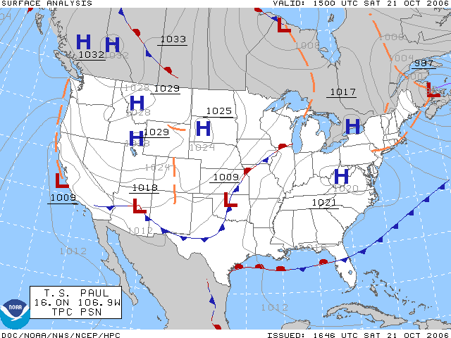
s, high-pressure centers are identified by the letter H. Weather maps in other languages may use different letters or symbols.
Formation
Troposphere
The troposphere is the lowest portion of Earth's atmosphere. It contains approximately 80% of the atmosphere's mass and 99% of its water vapor and aerosols....
, the atmospheric
Atmosphere
An atmosphere is a layer of gases that may surround a material body of sufficient mass, and that is held in place by the gravity of the body. An atmosphere may be retained for a longer duration, if the gravity is high and the atmosphere's temperature is low...
layer where weather
Weather
Weather is the state of the atmosphere, to the degree that it is hot or cold, wet or dry, calm or stormy, clear or cloudy. Most weather phenomena occur in the troposphere, just below the stratosphere. Weather refers, generally, to day-to-day temperature and precipitation activity, whereas climate...
occurs. Preferred areas within a synoptic
Synoptic scale meteorology
The synoptic scale in meteorology is a horizontal length scale of the order of 1000 kilometres or more. This corresponds to a horizontal scale typical of mid-latitude depressions...
flow pattern in higher levels of the troposphere are beneath the western side of troughs. On weather maps, these areas show converging winds (isotachs), also known as confluence
Confluence
Confluence, in geography, describes the meeting of two or more bodies of water.Confluence may also refer to:* Confluence , a property of term rewriting systems...
, or converging height lines near or above the level of non-divergence, which is near the 500 hPa pressure surface about midway up through the troposphere. High-pressure systems are alternatively referred to as anticyclones. On English-language weather maps, high-pressure centers are identified by the letter H in English, within the isobar with the highest pressure value. On constant pressure upper level charts, it is located within the highest height line contour.
Typical conditions
Subsidence (atmosphere)
Subsidence in the Earth's atmosphere is most commonly caused by low temperatures: as air cools, it becomes denser and moves towards the ground, just as warm air becomes less dense and moves upwards...
through the lower portion of the troposphere
Troposphere
The troposphere is the lowest portion of Earth's atmosphere. It contains approximately 80% of the atmosphere's mass and 99% of its water vapor and aerosols....
. In general, subsidence will dry out an air mass by adiabatic
Adiabatic process
In thermodynamics, an adiabatic process or an isocaloric process is a thermodynamic process in which the net heat transfer to or from the working fluid is zero. Such a process can occur if the container of the system has thermally-insulated walls or the process happens in an extremely short time,...
, or compressional, heating. Thus, high pressure typically brings clear skies. During the day, since no clouds are present to reflect sunlight, there is more incoming shortwave solar radiation and temperatures rise. At night, the absence of clouds means that outgoing longwave radiation (i.e. heat energy from the surface) is not absorbed, giving cooler diurnal
Diurnal temperature variation
Diurnal temperature variation is a meteorological term that relates to the variation in temperature that occurs from the highs of the day to the cool of nights.-Temperature lag:Temperature lag is an important factor in diurnal temperature variation...
low temperatures in all seasons. When surface winds become light, the subsidence produced directly under a high-pressure system can lead to a build up of particulates in urban areas under the ridge, leading to widespread haze
Haze
Haze is traditionally an atmospheric phenomenon where dust, smoke and other dry particles obscure the clarity of the sky. The World Meteorological Organization manual of codes includes a classification of horizontal obscuration into categories of fog, ice fog, steam fog, mist, haze, smoke, volcanic...
. If the low level relative humidity
Relative humidity
Relative humidity is a term used to describe the amount of water vapor in a mixture of air and water vapor. It is defined as the partial pressure of water vapor in the air-water mixture, given as a percentage of the saturated vapor pressure under those conditions...
rises towards 100 percent overnight, fog
Fog
Fog is a collection of water droplets or ice crystals suspended in the air at or near the Earth's surface. While fog is a type of stratus cloud, the term "fog" is typically distinguished from the more generic term "cloud" in that fog is low-lying, and the moisture in the fog is often generated...
can form.
Strong, vertically shallow high-pressure systems moving from higher latitudes to lower latitudes in the northern hemisphere are associated with continental arctic air masses. Once arctic air moves over an unfrozen ocean, the air mass modifies greatly over the warmer water and takes on the character of a maritime air mass, which reduces the strength of the high-pressure system. When extremely cold air moves over relatively warm oceans, polar low
Polar low
A polar low is a small-scale, long-lived atmospheric low pressure system that is found over the ocean areas poleward of the main polar front in both the Northern and Southern Hemispheres. The systems usually have a horizontal length scale of less than and exist for no more than a couple of days. ...
s can develop. However, warm and moist (or maritime tropical) air masses that move poleward from tropical sources are slower to modify than arctic air masses.
In climatology

Climatology
Climatology is the study of climate, scientifically defined as weather conditions averaged over a period of time, and is a branch of the atmospheric sciences...
, high pressure forms at the horse latitudes
Horse latitudes
Horse Latitudes or Subtropical High are subtropical latitudes between 30 and 35 degrees both north and south. This region, under a ridge of high pressure called the subtropical high, is an area which receives little precipitation and has variable winds mixed with calm.The consistently warm, dry...
, or torrid zone, between the latitudes of 20 and 40 degrees from the equator
Equator
An equator is the intersection of a sphere's surface with the plane perpendicular to the sphere's axis of rotation and containing the sphere's center of mass....
, as a result of air that has been uplifted at the equator
Equator
An equator is the intersection of a sphere's surface with the plane perpendicular to the sphere's axis of rotation and containing the sphere's center of mass....
. As the hot air rises it cools, losing moisture; it is then transported poleward where it descends, creating the high-pressure area. This is part of the Hadley cell circulation and is known as the subtropical ridge or subtropical high, and is strongest in the summer. The subtropical ridge is a warm core high-pressure system, meaning it strengthens with height. Many of the world's deserts are caused by these climatological high-pressure systems.
Some climatological high-pressure areas acquire regionally based names. The land-based Siberian High
Siberian High
The Siberian High is a massive collection of cold or very cold dry air that accumulates on the Eurasian terrain for much of the year. It reaches its greatest size and strength in the winter, when the air temperature near the center of the high-pressure cell or anticyclone is often lower than...
often remains quasi-stationary for more than a month during the most frigid time of the year, making it unique in that regard. It is also a bit larger and more persistent than its counterpart in North America
North America
North America is a continent wholly within the Northern Hemisphere and almost wholly within the Western Hemisphere. It is also considered a northern subcontinent of the Americas...
. Surface winds accelerating down valleys down the western Pacific ocean
Pacific Ocean
The Pacific Ocean is the largest of the Earth's oceanic divisions. It extends from the Arctic in the north to the Southern Ocean in the south, bounded by Asia and Australia in the west, and the Americas in the east.At 165.2 million square kilometres in area, this largest division of the World...
coastline, causing the winter monsoon. Arctic high-pressure systems such as the Siberian High are cold core, meaning that they weaken with height. The influence of the Azores High
Azores High
The Azores High is a large subtropical semi-permanent centre of high atmospheric pressure found near the Azores in the Atlantic Ocean, at the Horse latitudes...
, also known as the Bermuda High, brings fair weather over much of the North Atlantic Ocean
Atlantic Ocean
The Atlantic Ocean is the second-largest of the world's oceanic divisions. With a total area of about , it covers approximately 20% of the Earth's surface and about 26% of its water surface area...
and mid to late summer heat wave
Heat wave
A heat wave is a prolonged period of excessively hot weather, which may be accompanied by high humidity. There is no universal definition of a heat wave; the term is relative to the usual weather in the area...
s in western Europe
Europe
Europe is, by convention, one of the world's seven continents. Comprising the westernmost peninsula of Eurasia, Europe is generally 'divided' from Asia to its east by the watershed divides of the Ural and Caucasus Mountains, the Ural River, the Caspian and Black Seas, and the waterways connecting...
. Along its southerly periphery, the clockwise circulation often impels easterly waves, and tropical cyclones that develop from them, across the ocean towards landmasses in the western portion of ocean basins during the hurricane season
Hurricane season
Hurricane season refers to a period in a year when hurricanes usually form. For more information see: Tropical cyclone#Times.* The Atlantic hurricane seasonFor a lists of past seasons, see:...
. The highest barometric pressure ever recorded on Earth was 1085.7 hectopascals (32.1 inHg) measured in Tonsontsengel, Mongolia on 19 December 2001.
Connection to wind
WindWind
Wind is the flow of gases on a large scale. On Earth, wind consists of the bulk movement of air. In outer space, solar wind is the movement of gases or charged particles from the sun through space, while planetary wind is the outgassing of light chemical elements from a planet's atmosphere into space...
flows from areas of high pressure to areas of low pressure. This is due to density
Density
The mass density or density of a material is defined as its mass per unit volume. The symbol most often used for density is ρ . In some cases , density is also defined as its weight per unit volume; although, this quantity is more properly called specific weight...
differences between the two air mass
Air mass
In meteorology, an air mass is a volume of air defined by its temperature and water vapor content. Air masses cover many hundreds or thousands of square miles, and adopt the characteristics of the surface below them. They are classified according to latitude and their continental or maritime...
es. Since stronger high-pressure systems contain cooler or drier air, the air mass is more dense and flows towards areas that are warm or moist, which are in the vicinity of low pressure areas in advance of their associated cold front
Cold front
A cold front is defined as the leading edge of a cooler mass of air, replacing a warmer mass of air.-Development of cold front:The cooler and denser air wedges under the less-dense warmer air, lifting it...
s. The stronger the pressure difference, or pressure gradient, between a high-pressure system and a low pressure system, the stronger the wind. The coriolis force caused by the Earth
Earth
Earth is the third planet from the Sun, and the densest and fifth-largest of the eight planets in the Solar System. It is also the largest of the Solar System's four terrestrial planets...
's rotation is what gives winds within high-pressure systems their clockwise circulation in the northern hemisphere (as the wind moves outward and is deflected right from the center of high pressure) and counterclockwise circulation in the southern hemisphere (as the wind moves outward and is deflected left from the center of high pressure). Friction with land slows down the wind flowing out of high-pressure systems and causes wind to flow more outward than would be the case in the absence of friction. This is known as ageostrophic
Geostrophic wind
The geostrophic wind is the theoretical wind that would result from an exact balance between the Coriolis effect and the pressure gradient force. This condition is called geostrophic balance. The geostrophic wind is directed parallel to isobars . This balance seldom holds exactly in nature...
.