
Alaska Range
Encyclopedia
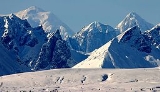
The Alaska Range is a relatively narrow, 650-km-long (400 mi) mountain range
in the southcentral region of the U.S. state
of Alaska
, from Lake Clark at its southwest end to the White River in Canada
's Yukon Territory in the southeast. The highest mountain in North America
, Denali, (or Mount McKinley
), is in the Alaska Range.
and the Aleutians, and trending southeast into the Pacific Coast Ranges
. The mountains act as a high barrier to the flow of moist air from the Gulf of Alaska
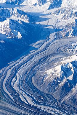
northwards, and thus has some of the harshest weather in the world. The heavy snowfall also contributes to a number of large glacier
s, including the Canwell, Castner, Black Rapids, Susitna, Yanert, Muldrow, Eldridge, Ruth, Tokositna, and Kahiltna Glaciers. Four major rivers cross the Range, including the Delta River
, and Nenana River
in the center of the range and the Nabesna and Chisana Rivers to the east.
 The range is part of the Pacific Ring of Fire
, and the Denali Fault
that runs along the southern edge of the range is responsible for a number of earthquake
s. Mount Spurr is a stratovolcano located in the northeastern end of the Aleutian Volcanic Arc of Alaska, USA which has two vents, the summit and nearby Crater Peak.
Parts of the range are protected within Wrangell-St. Elias National Park and Preserve
, Denali National Park and Preserve
, and Lake Clark National Park and Preserve
. The George Parks Highway
from Anchorage
to Fairbanks
, the Richardson Highway
from Valdez
to Fairbanks, and the Tok Cut-Off
from Gulkana Junction to Tok, Alaska
pass through low parts of the range. The Alaska Pipeline parallels the Richardson Highway
.
. The name eventually became "Alaska Range" through local use. In 1849 Constantin Grewingk applied the name "Tschigmit" to this mountain range. A map made by the General Land Office
in 1869 calls the southwestern part of the Alaska Range the "Chigmit Mountains" and the northeastern part the "Beaver Mountains". However the Chigmit Mountains
are now considered part of the Aleutian Range
.

Mountain range
A mountain range is a single, large mass consisting of a succession of mountains or narrowly spaced mountain ridges, with or without peaks, closely related in position, direction, formation, and age; a component part of a mountain system or of a mountain chain...
in the southcentral region of the U.S. state
U.S. state
A U.S. state is any one of the 50 federated states of the United States of America that share sovereignty with the federal government. Because of this shared sovereignty, an American is a citizen both of the federal entity and of his or her state of domicile. Four states use the official title of...
of Alaska
Alaska
Alaska is the largest state in the United States by area. It is situated in the northwest extremity of the North American continent, with Canada to the east, the Arctic Ocean to the north, and the Pacific Ocean to the west and south, with Russia further west across the Bering Strait...
, from Lake Clark at its southwest end to the White River in Canada
Canada
Canada is a North American country consisting of ten provinces and three territories. Located in the northern part of the continent, it extends from the Atlantic Ocean in the east to the Pacific Ocean in the west, and northward into the Arctic Ocean...
's Yukon Territory in the southeast. The highest mountain in North America
North America
North America is a continent wholly within the Northern Hemisphere and almost wholly within the Western Hemisphere. It is also considered a northern subcontinent of the Americas...
, Denali, (or Mount McKinley
Mount McKinley
Mount McKinley or Denali in Alaska, United States is the highest mountain peak in North America and the United States, with a summit elevation of above sea level. It is the centerpiece of Denali National Park and Preserve.- Geology and features :Mount McKinley is a granitic pluton...
), is in the Alaska Range.
Description and history
The range forms a generally east-west arc with its northernmost part in the center, and from there trending southwest towards the Alaska PeninsulaAlaska Peninsula
The Alaska Peninsula is a peninsula extending about to the southwest from the mainland of Alaska and ending in the Aleutian Islands. The peninsula separates the Pacific Ocean from Bristol Bay, an arm of the Bering Sea....
and the Aleutians, and trending southeast into the Pacific Coast Ranges
Pacific Coast Ranges
The Pacific Coast Ranges and the Pacific Mountain System are the series of mountain ranges that stretch along the West Coast of North America from Alaska south to Northern and Central Mexico...
. The mountains act as a high barrier to the flow of moist air from the Gulf of Alaska
Gulf of Alaska
The Gulf of Alaska is an arm of the Pacific Ocean defined by the curve of the southern coast of Alaska, stretching from the Alaska Peninsula and Kodiak Island in the west to the Alexander Archipelago in the east, where Glacier Bay and the Inside Passage are found.The entire shoreline of the Gulf is...
northwards, and thus has some of the harshest weather in the world. The heavy snowfall also contributes to a number of large glacier
Glacier
A glacier is a large persistent body of ice that forms where the accumulation of snow exceeds its ablation over many years, often centuries. At least 0.1 km² in area and 50 m thick, but often much larger, a glacier slowly deforms and flows due to stresses induced by its weight...
s, including the Canwell, Castner, Black Rapids, Susitna, Yanert, Muldrow, Eldridge, Ruth, Tokositna, and Kahiltna Glaciers. Four major rivers cross the Range, including the Delta River
Delta River
The Delta River is a tributary of the Tanana River, which in turn is a tributary of the Yukon River in Alaska in the United States....
, and Nenana River
Nenana River
The Nenana River is a tributary of the Tanana River, approximately 150 mi long, in central Alaska in the United States. It drains an area on the north slope of the Alaska Range on the south edge of the Tanana Valley southwest of Fairbanks....
in the center of the range and the Nabesna and Chisana Rivers to the east.
Pacific Ring of Fire
The Pacific Ring of Fire is an area where large numbers of earthquakes and volcanic eruptions occur in the basin of the Pacific Ocean. In a horseshoe shape, it is associated with a nearly continuous series of oceanic trenches, volcanic arcs, and volcanic belts and/or plate movements...
, and the Denali Fault
Denali Fault
The Denali Fault is a major intracontinental dextral strike-slip fault in western North America, extending from northwestern British Columbia, Canada to the U.S. state of central Alaska. It was the main fault along which the 2002 Denali earthquake occurred, which was measured as a magnitude of 7.9...
that runs along the southern edge of the range is responsible for a number of earthquake
Earthquake
An earthquake is the result of a sudden release of energy in the Earth's crust that creates seismic waves. The seismicity, seismism or seismic activity of an area refers to the frequency, type and size of earthquakes experienced over a period of time...
s. Mount Spurr is a stratovolcano located in the northeastern end of the Aleutian Volcanic Arc of Alaska, USA which has two vents, the summit and nearby Crater Peak.
Parts of the range are protected within Wrangell-St. Elias National Park and Preserve
Wrangell-St. Elias National Park and Preserve
Wrangell–St. Elias National Park and Preserve is a United States National Park in southeastern Alaska. It was established in 1980 by the Alaska National Interest Lands Conservation Act. The park area is included in an International Biosphere Reserve and is part of a UNESCO World Heritage Site...
, Denali National Park and Preserve
Denali National Park and Preserve
Denali National Park and Preserve is located in Interior Alaska and contains Denali , the highest mountain in North America. The park and preserve together cover 9,492 mi² .The longest glacier is the Kalhiltna glacier....
, and Lake Clark National Park and Preserve
Lake Clark National Park and Preserve
Established in 1980 by the Alaska National Interest Lands Conservation Act, Lake Clark National Park and Preserve is a United States National Park in southwestern Alaska. The park includes many streams and lakes vital to the Bristol Bay salmon fishery...
. The George Parks Highway
George Parks Highway
The George Parks Highway , usually called simply the Parks Highway, runs 323 miles from the Glenn Highway 35 miles north of Anchorage to Fairbanks in the Alaska Interior...
from Anchorage
Anchorage, Alaska
Anchorage is a unified home rule municipality in the southcentral part of the U.S. state of Alaska. It is the northernmost major city in the United States...
to Fairbanks
Fairbanks, Alaska
Fairbanks is a home rule city in and the borough seat of the Fairbanks North Star Borough in the U.S. state of Alaska.Fairbanks is the largest city in the Interior region of Alaska, and second largest in the state behind Anchorage...
, the Richardson Highway
Richardson Highway
The Richardson Highway is a highway in the U.S. state of Alaska, running 368 miles from Valdez to Fairbanks. It is marked as Alaska Route 4 from Valdez to Delta Junction and as Alaska Route 2 from there to Fairbanks. It is also connects segments of Alaska Route 1 between the Glenn Highway and the...
from Valdez
Valdez, Alaska
Valdez is a city in Valdez-Cordova Census Area in the U.S. state of Alaska. According to 2005 Census Bureau estimates, the population of the city is 4,020. The city is one of the most important ports in Alaska. The port of Valdez was named in 1790 after the Spanish naval officer Antonio Valdés y...
to Fairbanks, and the Tok Cut-Off
Tok Cut-Off
The Tok Cut-Off is a highway in the U.S. state of Alaska, running 125 miles from Gakona Junction on the Richardson Highway, 14 miles north of Glennallen, to Tok on the Alaska Highway....
from Gulkana Junction to Tok, Alaska
Tok, Alaska
Tok is a census-designated place in Southeast Fairbanks Census Area, Alaska, United States. The population was 1,393 at the 2000 census.-Geography:...
pass through low parts of the range. The Alaska Pipeline parallels the Richardson Highway
Richardson Highway
The Richardson Highway is a highway in the U.S. state of Alaska, running 368 miles from Valdez to Fairbanks. It is marked as Alaska Route 4 from Valdez to Delta Junction and as Alaska Route 2 from there to Fairbanks. It is also connects segments of Alaska Route 1 between the Glenn Highway and the...
.
Naming history
The name "Alaskan Range" appears to have been first applied to these mountains in 1869 by naturalist W. H. DallW. H. Dall
William Healey Dall was an American naturalist, a prominent malacologist, and one of the earliest scientific explorers of interior Alaska...
. The name eventually became "Alaska Range" through local use. In 1849 Constantin Grewingk applied the name "Tschigmit" to this mountain range. A map made by the General Land Office
General Land Office
The General Land Office was an independent agency of the United States government responsible for public domain lands in the United States. It was created in 1812 to take over functions previously conducted by the United States Department of the Treasury...
in 1869 calls the southwestern part of the Alaska Range the "Chigmit Mountains" and the northeastern part the "Beaver Mountains". However the Chigmit Mountains
Chigmit Mountains
The Chigmit Mountains are a subrange of the Aleutian Range in the Kenai Peninsula and Lake and Peninsula Boroughs of the U.S. state of Alaska.-Location:...
are now considered part of the Aleutian Range
Aleutian Range
The Aleutian Range is a major mountain range of southwest Alaska, extending from Chakachamna Lake to Unimak Island, at the tip of the Alaska Peninsula. It includes all of the mountains of the Peninsula. It is especially notable for its large number of active volcanoes, which are also part of the...
.
Major peaks
- Mount McKinleyMount McKinleyMount McKinley or Denali in Alaska, United States is the highest mountain peak in North America and the United States, with a summit elevation of above sea level. It is the centerpiece of Denali National Park and Preserve.- Geology and features :Mount McKinley is a granitic pluton...
(6,194 m/20,320 ft) - Mount ForakerMount ForakerMount Foraker is a mountain in the central Alaska Range, in Denali National Park, southwest of Mount McKinley. It is the second highest peak in the Alaska Range, and the fourth highest peak in the United States...
(5,304 m/17,400 ft) - Mount HunterMount Hunter (Alaska)Mount Hunter, or Begguya, is a mountain in Denali National Park in Alaska. It is approximately 8 miles south of Mount McKinley, or Denali, the highest peak in North America. "Begguya" means child in the Dena'ina language...
(4,442 m/14,573 ft) - Mount HayesMount HayesMount Hayes is the highest mountain in the eastern Alaska Range. Despite not being a fourteener, it is one of the largest peaks in the United States in terms of rise above local terrain. For example, the Northeast Face rises 8,000 feet in approximately 2 miles...
(4,216 m/13,832 ft) - Mount SilverthroneMount Silverthrone (Alaska)Mount Silverthrone is a massive glaciated mountain on the east side of Mount McKinley, Alaska, United States.-References:* in the Canadian Mountain Encyclopedia...
(4,029 m/13,218 ft) - Mount DeborahMount DeborahMount Deborah is a mountain in the U.S. state of Alaska. It is one of the major peaks of the eastern Alaska Range. Despite its low absolute elevation , it is a particularly large and steep peak in terms of its quick rise over local terrain. For example, the Northeast Face rises 7000 feet in...
(3,761 m/12,339 ft) - Mount Huntington (3,730 m/12,240 ft)
- Mount RussellMount Russell (Alaska)Mount Russell is one of the major peaks of the central Alaska Range, approximately 35 mi southwest of Mount McKinley . Though much lower than McKinley or its neighbor Mount Foraker, Russell is a steep, dramatic peak and a significant mountaineering challenge in its own right...
(3,557 m/11,670 ft)
Subranges (from west to east)
- Neacola MountainsNeacola MountainsThe Neacola Mountains are the northernmost subrange of the Aleutian Range in Alaska. They are bordered on the southeast by the Chigmit Mountains, on the northeast by the Tordrillo Mountains, on the northwest by the southern tip of the Alaska Range, and on the west and southwest by the lakes and...
- Revelation MountainsRevelation MountainsThe Revelation Mountains are a small, rugged subrange of the Alaska Range in Alaska, United States. They mark the furthest western extent of the Alaska Range. The range is rarely visited because of the flying time necessary to get there and also because of notoriously poor weather conditions that...
- Teocalli Mountains
- Kichatna MountainsKichatna MountainsThe Kichatna Mountains are a small mountain range in the northwestern part of Matanuska-Susitna Borough of the U.S. state of Alaska, approximately southwest of Mount McKinley...
- Central Alaska Range/Denali Massif
- Eastern Alaska Range/HayesMount HayesMount Hayes is the highest mountain in the eastern Alaska Range. Despite not being a fourteener, it is one of the largest peaks in the United States in terms of rise above local terrain. For example, the Northeast Face rises 8,000 feet in approximately 2 miles...
Range - Delta MountainsDelta MountainsThe Delta Mountains are a subrange of the Alaska Range, forming its eastern terminus. Their highest point is Mount Kimball, which measures . They are drained by the Delta River on the west and the Tanana and Nebesna rivers to the northeast....
- Mentasta MountainsMentasta MountainsThe Mentasta Mountains in the eastern part of the US state of Alaska form the eastern end of the Alaska Range.They lie south of the Alaska Highway, east of the Glenn Highway, north of the Wrangell Mountains, and west of the Nabesna River. Across the Glenn Highway lies the continuation of the Alaska...
- Nutzotin MountainsNutzotin MountainsThe Nutzotin Mountains are a mountain range in Alaska, United States and Yukon, Canada. It has an area of 829 km2 and is a subrange of the Alaska Range, of which they lie at the southeastern end. The portion of the range in the United States is split between the Southeast Fairbanks and...
Documented wilderness traverses of Alaska Range
- Mentasta Lake to Kitchatna Mountains (1981): Scott Woolums, George Beilstein, Steve Eck, and Larry Coxen by skis: first traverse. 375 miles (603.5 km) in 45 days.
- Canada to Lake Clark (1996): Roman Dial, Carl Tobin, and Paul Adkins by mountain bike and packraftPackraftPackraft and trail boat are colloquial terms for a small, portable inflatable boat designed for use in all bodies of water, including technical whitewater and ocean bays and fjords. A packraft is designed to be light enough to be carried for extended distances...
: first full length traverse. 775 miles (1,247.2 km) in 42 days. - Tok to Lake Clark (1996): Kevin Armstrong, Doug Woody, and Jeff Ottmers by snowshoe, foot, and packraftPackraftPackraft and trail boat are colloquial terms for a small, portable inflatable boat designed for use in all bodies of water, including technical whitewater and ocean bays and fjords. A packraft is designed to be light enough to be carried for extended distances...
: first foot traverse. 620 miles (997.8 km) in 90 days.
Further reading
- Churkin, M., Jr., and C. Carter. (1996). Stratigraphy, structure, and graptolites of an Ordovician and Silurian sequence in the Terra Cotta Mountains, Alaska Range, Alaska [U.S. Geological Survey Professional Paper 1555]. Washington, D.C.: U.S. Department of the Interior, U.S. Geological Survey.