
Maryland Route 168
Encyclopedia
Maryland Route 168, better known as Nursery Road, is a road in Anne Arundel County, Maryland
in the area of BWI Airport.
As Maryland Route 168, Nursery Road continues east, quickly passing under I-695
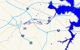
(the Baltimore Beltway). The route passes through the North Linthicum area, passing over MD 295 again. It then enters a residential neighborhood and meets Maryland Route 648
(Baltimore–Annapolis Boulevard), where both Nursery Road and MD 168 end. Across from this intersection is the Nursery Road Light Rail Stop on the Baltimore Light Rail
.
Bus Route 17.
.
Anne Arundel County, Maryland
Anne Arundel County is a county located in the U.S. state of Maryland. It is named for Anne Arundell , a member of the ancient family of Arundells in Cornwall, England and the wife of Cæcilius Calvert, 2nd Baron Baltimore. Its county seat is Annapolis, which is also the capital of the state...
in the area of BWI Airport.
Route description
Nursery Road, without the MD 168 designation, starts off at BWI Airport at Elkridge Landing Road The road starts as a two-lane road, but this grows to four lanes as it continues north from there through the BWI business district in Linthicum Heights, intersecting the west end of MD 762 (Andover Road). After this intersection, the road widens further to a six-lane divided boulevard, but only until it meets Maryland Route 295 at a diamond interchange. The route curves to the east, now a two-lane road sometimes featuring a shared left-turn lane, until it reaches Hammonds Ferry Road. Here, Nursery Road picks up the MD 168 designation.As Maryland Route 168, Nursery Road continues east, quickly passing under I-695
Interstate 695 (Maryland)
Interstate 695 is a -long full beltway Interstate Highway extending around Baltimore, Maryland, USA. I-695 is officially designated the McKeldin Beltway, but is colloquially referred to as either the Baltimore Beltway or 695...
(the Baltimore Beltway). The route passes through the North Linthicum area, passing over MD 295 again. It then enters a residential neighborhood and meets Maryland Route 648
Maryland Route 648
Maryland Route 648 is a collection of state highways in the U.S. state of Maryland. These highways are sections of Baltimore–Annapolis Boulevard, the old alignment of MD 2 between Annapolis and Glen Burnie. These segments were bypassed when MD 2 was moved to Governor Ritchie Highway, a...
(Baltimore–Annapolis Boulevard), where both Nursery Road and MD 168 end. Across from this intersection is the Nursery Road Light Rail Stop on the Baltimore Light Rail
Baltimore Light Rail
The Maryland Transit Administration Light Rail is a light rail system serving Baltimore, Maryland, United States, and the surrounding suburbs.In downtown Baltimore it uses city streets...
.
Public transportation
Public transportation is available along all parts of Nursery Road on Maryland Transit AdministrationMaryland Transit Administration
The Maryland Transit Administration is a state-operated mass transit administration in Maryland, and is part of the Maryland Department of Transportation. It is better known as MTA Maryland to avoid confusion with other cities' transit agencies who share the initials MTA. The MTA operates a...
Bus Route 17.
Junction list
The entire route is in Anne Arundel CountyAnne Arundel County, Maryland
Anne Arundel County is a county located in the U.S. state of Maryland. It is named for Anne Arundell , a member of the ancient family of Arundells in Cornwall, England and the wife of Cæcilius Calvert, 2nd Baron Baltimore. Its county seat is Annapolis, which is also the capital of the state...
.
| Location | Mile |
Intersection | Notes |
|---|---|---|---|
| Linthicum Linthicum, Maryland Linthicum is a census-designated place and an unincorporated community in Anne Arundel County, Maryland, United States. The population was 7,539 at the 2000 census. It is the approximate location of Baltimore-Washington International Thurgood Marshall Airport... |
0.00 | Hammonds Ferry Road | Western terminus |
| 0.21 | I-695 exit 8 | ||
| North Linthicum | 0.77 | ||
| 1.28 | Eastern terminus |