
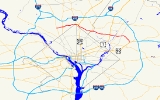
Maryland Route 410
Encyclopedia
Maryland Route 410 is a state highway
in the U.S. state
of Maryland
. Known for most of its length as East–West Highway, the highway runs 13.92 mi (22.4 km) from MD 355
in Bethesda
east to Pennsy Drive in Landover Hills
. MD 410 serves as a major east–west commuter route through the inner suburbs on the north side of Washington, D.C.
, connecting the commercial districts of Bethesda, Silver Spring
, and Hyattsville
; the industrial area of Landover Hills; and the residential suburbs of Chevy Chase
, Takoma Park
, Riverdale
. and East Riverdale
. The road connects many of the arterial highways and freeways that head out of Washington as well as transit hubs centered around stations of the Washington Metro
in Bethesda, Silver Spring, Hyattsville, and New Carrollton
, with additional connections to MARC
and Amtrak
. The highway is maintained mostly by the Maryland State Highway Administration
(MDSHA), with small segments maintained by the city of Takoma Park and Prince George's County
.
MD 410 was originally built along mostly new alignment between Bethesda and Silver Spring in the late 1920s. The highway was extended east to Hyattsville in the mid 1930s. While the Montgomery County
portion has not changed much in the ensuing decades, MD 410 has been realigned and extended multiple times within Prince George's County. These changes include an extension along existing roads further into Hyattsville in the mid 1940s, a realignment within Hyattsville in the mid 1950s, an extension through Riverdale in the late 1960s, and the final extension to Landover Hills in the early 1990s.
of streets at the intersection of MD 355 (Wisconsin Avenue) and MD 187
(Old Georgetown Road) at the Bethesda
station of the Washington Metro
. Montgomery Avenue heads eastbound from MD 355 while the westbound direction is East–West Highway, which passes the Consumer Product Safety Commission
and Bethesda-Chevy Chase High School
. At the east end of Bethesda's central business district, MD 410 east has a U-turn ramp to MD 410 west, then the two streets come together and head east toward Chevy Chase as East–West Highway.
 After crossing the Capital Crescent Trail
, MD 410 continues east as a four-lane undivided highway with a speed limit of 30 mph (48.3 km/h) through residential areas. The state highway passes Maple Avenue, which was formerly MD 82, on the edge of the town of Chevy Chase
. MD 410 parallels Columbia Country Club
to the south before intersecting MD 185
(Connecticut Avenue). Beyond MD 185, the speed limit increases to 35 mph (56.3 km/h). After meeting the northern terminus of MD 186
(Brookville Road), the state highway turns northeast and heads into the valley of Rock Creek
. MD 410 meets Jones Mill Road and Beach Drive before crossing Rock Creek, then intersects Meadowbrook Drive. Continuing northeast, the state highway gains a narrow median and intersects Grubb Road. After passing the intersection of Washington Avenue and Sundale Drive, MD 410 becomes undivided again and enters an area of high-rise and garden apartments. After passing Rosemary Hills Drive, the state highway curves to the east and comes very close to the north corner boundary of the District of Columbia.
Upon entering Silver Spring, MD 410 intersects MD 390
(16th Street). The state highway curves to the southeast to meet MD 384
(Colesville Road) next to the Silver Spring
Metro station and the Silver Spring offices of the National Oceanic and Atmospheric Administration
. After the speed limit reduces to 30 mph (48.3 km/h), MD 410 continues southeast, passing the intersection of Blair Mill Road and Newell Street before arriving at the five-way intersection with U.S. Route 29
(Georgia Avenue
). From US 29, the state highway turns east onto Burlington Avenue and crosses CSX
's Metropolitan Subdivision, MARC's Brunswick Line
, and the Red Line
of the Washington Metro. At Fenton Street, MD 410 veers southeast onto Philadelphia Avenue, which heads into Takoma Park.
 MD 410 enters Takoma Park as a two-lane road with a speed limit of 30 mph (48.3 km/h) through a densely populated residential area. After passing the Takoma Park/Silver Spring campus of Montgomery College
, the state highway intersects MD 320
(Piney Branch Road). After a four-way stop at Holly Avenue, MD 410 turns east and intersects Maple Avenue, where the speed limit decreases to 25 mph (40.2 km/h). The state highway heads toward an intersection with MD 195
(Carroll Avenue) in front of the Takoma Park Volunteer Fire Department. After a short concurrency
with MD 195 through Takoma Junction, MD 410 continues east on Ethan Allen Avenue. After a three-way stop at Jackson Avenue, the state highway reaches an intersection with MD 650
(New Hampshire Avenue
), where MD 410 leaves Takoma Park and Montgomery County.
and the Sligo Creek Trail
before entering a commercial area and meeting MD 212
(Riggs Road). Shortly after MD 212, Ager Road continues southeast straight toward the West Hyattsville
Metro station while MD 410 veers east as a four-lane divided highway with a speed limit of 40 mph (64.4 km/h). After crossing Northwest Branch
, the state highway enters a commercial area where it passes between The Mall at Prince Georges on the north and the Prince George's Plaza
Metro station on the south. After crossing Belcrest Road, which is used to access University Town Center and the National Center for Health Statistics
, MD 410 intersects MD 500
(Queens Chapel Road) and Adelphi Road and leaves Hyattsville.
MD 410 expands to a six-lane divided highway with a speed limit of 35 mph (56.3 km/h) after the MD 500 intersection and passes through a residential area on the southern edge of University Park
. The state highway then reaches US 1
and enters Riverdale Park and the town's historic district
. MD 410 reduces to a four-lane divided highway and crosses CSX's Capital Subdivision and MARC's Camden Line
. The state highway then crosses Northeast Branch
and meets MD 201
(Kenilworth Avenue). After crossing MD 201, MD 410 again expand to six lanes. After the intersection with Riverdale Road, the state highway enters the unincorporated area of East Riverdale and assumes the name Riverdale Road. MD 410 changes to a five-lane road with center turn lane with a speed limit of 40 mph (64.4 km/h) as it passes through residential areas. The state highway meets the Baltimore-Washington Parkway
(unsigned MD 295) at a diamond interchange
. Just east of the parkway, Riverdale Road continues straight toward New Carrollton while MD 410 turns south into Veterans Parkway.
MD 410 heads south through a forested area as a four-lane divided highway with a speed limit of 45 mph (72.4 km/h). The state highway intersects MD 450
(Annapolis Road) as the road reaches Landover Hills. MD 410's next intersection is with Ellin Road, which leads to a secondary entrance and park and ride
for the New Carrollton
Metro station. The state highway meets US 50
(John Hansen Highway) at a diamond interchange, then crosses the Amtrak Northeast Corridor, MARC's Penn Line
, and the Orange Line
of the Washington Metro. After crossing the railroad tracks, MD 410 enters Ardwick Ardmore Industrial Park and meets its eastern terminus at Pennsy Drive, which heads east toward the primary entrance for the New Carrollton Metro station and Ardwick-Ardmore Road.
in Bethesda and 16th Street in Silver Spring, which had been extended north from the District of Columbia in 1928. Continuing to the present center of Silver Spring required heading south on 16th Street to Blair Portal, then east on Colesville Road, which had been extended to Blair Portal in 1927, to Georgia Avenue. Most of MD 410 was built on a new alignment with the exception of the part between present day MD 186 and Jones Mill Road, which followed the old Brookville Road.
By 1933, the new state highway was the busiest road in Montgomery County. The road, which became known as East–West Highway, was originally built with a width of 20 feet, but the heavy traffic led the Maryland State Roads Commission (SRC), the predecessor of MDSHA, to suggest in 1934 that the road be widened to 40 feet in the near future. SRC also recommended extending East–West Highway through Silver Spring and Takoma Park to Hyattsville. By 1935, the highway was extended along new alignment east from 16th Street to Takoma Park, then placed on Philadelphia Avenue and Ethan Allen Avenue within Takoma Park. The extension to MD 212 in Hyattsville was completed in 1936.
After World War II, MD 410 was extended even further east and saw significant improvement on its extant sections. By 1946, MD 410 was extended over Ager Road, Hamilton Street, 38th Avenue, and Jefferson Avenue, roads then designated MD 209, to a new eastern terminus at US 1 in Hyattsville. In addition, the pre-1946 course saw completion of efforts to widen the road to 40 feet. The highway between Connecticut Avenue (then MD 193) and Georgia Avenue (US 29) was widened in 1946 and 1947. The two segments between Wisconsin Avenue (US 240) and Connecticut Avenue (MD 193) and between MD 650 in Takoma Park and US 1 in Hyattsville were widened in 1950.
Beyond minor improvements, MD 410 in Montgomery County has remained in much the same state since 1950. The only major change was the highway being split onto a one-way pair of streets in Bethesda in 1988. The Prince George's County section has seen more substantial changes over the intervening decades. The first major change in alignment occurred in 1956, when MD 410 was completed on a new alignment as a four-lane divided highway between Ager Road just east of MD 212 and MD 500 at what is now Adelphi Road. The state highway was subsequently extended east over what was previously MD 403, known as Colesville Road, to US 1 in Riverdale.
The next change occurred between 1967 and 1970, when MD 410 was extended as a four-lane divided highway on a new alignment east past MD 201 to the Baltimore–Washington Parkway. This extension bypassed and replaced MD 412 between US 1 and the B-W Parkway. The adjoining segment of MD 410 between MD 500 and US 1 was also upgraded to a multi-lane divided highway by 1970. Finally, MD 410 was extended east on Veterans Parkway past US 50 to its current terminus at Pennsy Drive when that section of highway was completed in 1991.
!County
!Location
!Mile
!Destinations
!Notes
|-
|rowspan=13|Montgomery
|rowspan=2|Bethesda
|0.00
|, Washington
|rowspan=1|Western terminus
Begin one-way pair
|-
|0.45
|U-turn to
|rowspan=1|End one-way pair
|-
|rowspan=4|Chevy Chase
|0.72
|Maple Avenue west – Town of Chevy Chase
|rowspan=1|Former MD 82
|-
|1.01
|, Washington
|-
|1.38
|
|-
|1.89
|Beach Drive south / Jones Mill Road north – Washington
, North Chevy Chase
|-
|rowspan=3|Silver Spring
|3.48
| – Washington
, Wheaton
|-
|3.71
| – Downtown Silver Spring
, Columbia
|-
|4.24
| – Washington
, Downtown Silver Spring
|-
|rowspan=4|Takoma Park
|4.96
|, Washington
|-
|5.56
|
|rowspan=1|West end of concurrency with MD 195
|-
|5.63
|
|rowspan=1|East end of concurrency with MD 195
|-
|6.31
|, Washington
|-
|rowspan=10|Prince George's
|rowspan=3|Hyattsville
|
|
|-
|
|Ager Road east – Hyattsville
|rowspan=1|Old alignment of MD 410
|-
|
| / Adelphi Road north – Chillum
, University Park
|-
|rowspan=2|Riverdale Park
|
|
|-
|
|
|-
|rowspan=2|East Riverdale
|
|, Washington
|-
|
|Riverdale Road east – New Carrollton
|rowspan=1|MD 410 turns south onto Veterans Parkway
|-
|rowspan=3|Landover Hills
|
|
|-
|
|, Washington
|rowspan=1|US 50 Interchange 5
|-
|
|Pennsy Drive
|Eastern terminus
|-
State highway
State highway, state road or state route can refer to one of three related concepts, two of them related to a state or provincial government in a country that is divided into states or provinces :#A...
in the U.S. state
U.S. state
A U.S. state is any one of the 50 federated states of the United States of America that share sovereignty with the federal government. Because of this shared sovereignty, an American is a citizen both of the federal entity and of his or her state of domicile. Four states use the official title of...
of Maryland
Maryland
Maryland is a U.S. state located in the Mid Atlantic region of the United States, bordering Virginia, West Virginia, and the District of Columbia to its south and west; Pennsylvania to its north; and Delaware to its east...
. Known for most of its length as East–West Highway, the highway runs 13.92 mi (22.4 km) from MD 355
Maryland Route 355
Maryland Route 355 is a north–south road in western central Maryland in the United States. The southern terminus of the route is at the Washington, D.C. border in Friendship Heights, Montgomery County, where it continues south as Wisconsin Avenue into Washington. The northern terminus is...
in Bethesda
Bethesda, Maryland
Bethesda is a census designated place in southern Montgomery County, Maryland, United States, just northwest of Washington, D.C. It takes its name from a local church, the Bethesda Meeting House , which in turn took its name from Jerusalem's Pool of Bethesda...
east to Pennsy Drive in Landover Hills
Landover Hills, Maryland
Landover Hills is a town in Prince George's County, Maryland, United States. The population was 1,534 at the 2000 census.It has a neighborhood named Defense Heights.-Bordering areas:* Woodlawn * Greater Landover...
. MD 410 serves as a major east–west commuter route through the inner suburbs on the north side of Washington, D.C.
Washington, D.C.
Washington, D.C., formally the District of Columbia and commonly referred to as Washington, "the District", or simply D.C., is the capital of the United States. On July 16, 1790, the United States Congress approved the creation of a permanent national capital as permitted by the U.S. Constitution....
, connecting the commercial districts of Bethesda, Silver Spring
Silver Spring, Maryland
Silver Spring is an unincorporated area and census-designated place in Montgomery County, Maryland, United States. It had a population of 71,452 at the 2010 census, making it the fourth most populous place in Maryland, after Baltimore, Columbia, and Germantown.The urbanized, oldest, and...
, and Hyattsville
Hyattsville, Maryland
Hyattsville is a city in Prince George's County, Maryland, United States. The population was 17,557 at the 2000 census.- History :The city was named for its founder, Christopher Clark Hyatt. He purchased his first parcel of land in the area in March 1845...
; the industrial area of Landover Hills; and the residential suburbs of Chevy Chase
Chevy Chase, Maryland
Chevy Chase is the name of both a town and an unincorporated census-designated place in Montgomery County, Maryland. In addition, a number of villages in the same area of Montgomery County include "Chevy Chase" in their names...
, Takoma Park
Takoma Park, Maryland
Takoma Park is a city in Montgomery County, Maryland, United States. It is a suburb of Washington, D.C., and part of the Washington Metropolitan Area. Founded in 1883 and incorporated in 1890, Takoma Park, informally called "Azalea City," is a Tree City USA and a nuclear-free zone...
, Riverdale
Riverdale Park, Maryland
Riverdale Park is a town in Prince George's County, Maryland, United States. The population was 6,690 at the 2000 census.-Geography:Riverdale Park is located at ....
. and East Riverdale
East Riverdale, Maryland
East Riverdale is an unincorporated area and census-designated place in Prince George's County, Maryland, United States. The population was 14,961 at the 2000 census.-Geography:East Riverdale is located at ....
. The road connects many of the arterial highways and freeways that head out of Washington as well as transit hubs centered around stations of the Washington Metro
Washington Metro
The Washington Metro, commonly called Metro, and unofficially Metrorail, is the rapid transit system in Washington, D.C., United States, and its surrounding suburbs. It is administered by the Washington Metropolitan Area Transit Authority , which also operates Metrobus service under the Metro name...
in Bethesda, Silver Spring, Hyattsville, and New Carrollton
New Carrollton, Maryland
New Carrollton is a city located in central Prince George's County, Maryland, in the United States. As of the 2000 census, population was 12,589.New Carrollton is 12.11 miles from central Washington, DC....
, with additional connections to MARC
MARC Train
MARC , known prior to 1984 as Maryland Rail Commuter Service, is a regional rail system comprising three lines in the Baltimore-Washington Metropolitan Area. MARC is administered by the Maryland Transit Administration , a Maryland Department of Transportation agency, and is operated under contract...
and Amtrak
Amtrak
The National Railroad Passenger Corporation, doing business as Amtrak , is a government-owned corporation that was organized on May 1, 1971, to provide intercity passenger train service in the United States. "Amtrak" is a portmanteau of the words "America" and "track". It is headquartered at Union...
. The highway is maintained mostly by the Maryland State Highway Administration
Maryland State Highway Administration
The Maryland State Highway Administration is the state agency responsible for maintaining Maryland numbered highways outside of Baltimore City...
(MDSHA), with small segments maintained by the city of Takoma Park and Prince George's County
Prince George's County, Maryland
Prince George's County is a county located in the U.S. state of Maryland, immediately north, east, and south of Washington, DC. As of 2010, it has a population of 863,420 and is the wealthiest African-American majority county in the nation....
.
MD 410 was originally built along mostly new alignment between Bethesda and Silver Spring in the late 1920s. The highway was extended east to Hyattsville in the mid 1930s. While the Montgomery County
Montgomery County, Maryland
Montgomery County is a county in the U.S. state of Maryland, situated just to the north of Washington, D.C., and southwest of the city of Baltimore. It is one of the most affluent counties in the United States, and has the highest percentage of residents over 25 years of age who hold post-graduate...
portion has not changed much in the ensuing decades, MD 410 has been realigned and extended multiple times within Prince George's County. These changes include an extension along existing roads further into Hyattsville in the mid 1940s, a realignment within Hyattsville in the mid 1950s, an extension through Riverdale in the late 1960s, and the final extension to Landover Hills in the early 1990s.
Montgomery County
The western end of MD 410 begins as a one-way pairOne-way pair
A one-way pair, one-way couple, or just couplet is a pair of parallel, usually one-way streets that carry opposite directions of a signed route or major traffic flow, or sometimes opposite directions of a bus or streetcar route....
of streets at the intersection of MD 355 (Wisconsin Avenue) and MD 187
Maryland Route 187
Maryland Route 187 is a state highway in the U.S. state of Maryland. Known as Old Georgetown Road, the state highway runs from MD 355 and MD 410 in Bethesda north to MD 355 in North Bethesda...
(Old Georgetown Road) at the Bethesda
Bethesda (Washington Metro)
Bethesda is an island platformed Washington Metro station in Bethesda, Maryland, United States. The station was opened on August 25, 1984, and is operated by the Washington Metropolitan Area Transit Authority . Providing service for the Red Line, the station serves downtown Bethesda and is below...
station of the Washington Metro
Washington Metro
The Washington Metro, commonly called Metro, and unofficially Metrorail, is the rapid transit system in Washington, D.C., United States, and its surrounding suburbs. It is administered by the Washington Metropolitan Area Transit Authority , which also operates Metrobus service under the Metro name...
. Montgomery Avenue heads eastbound from MD 355 while the westbound direction is East–West Highway, which passes the Consumer Product Safety Commission
Consumer Product Safety Commission
The United States Consumer Product Safety Commission is an independent agency of the United States government created in 1972 through the Consumer Product Safety Act to protect "against unreasonable risks of injuries associated with consumer products." The CPSC is an independent agency that does...
and Bethesda-Chevy Chase High School
Bethesda-Chevy Chase High School
Bethesda-Chevy Chase High School is a Montgomery County, Maryland, USA, public school named for two of the towns it serves along with Kensington and Silver Spring, Maryland. It is located at 4301 East-West Highway, in Bethesda, an unincorporated community in Montgomery County...
. At the east end of Bethesda's central business district, MD 410 east has a U-turn ramp to MD 410 west, then the two streets come together and head east toward Chevy Chase as East–West Highway.
Capital Crescent Trail
The Capital Crescent Trail is an long, shared-use rail trail that runs from Georgetown in Washington, D.C., to Silver Spring, Maryland. The portion from Bethesda to Silver Spring is also called the Georgetown Branch Trail but is recognized as the Future Capital Crescent Trail.The Capital Crescent...
, MD 410 continues east as a four-lane undivided highway with a speed limit of 30 mph (48.3 km/h) through residential areas. The state highway passes Maple Avenue, which was formerly MD 82, on the edge of the town of Chevy Chase
Chevy Chase (town), Maryland
Chevy Chase is an incorporated town in Montgomery County, Maryland, United States. The population was 2,726 at the 2000 census.-Geography:Chevy Chase is located at ....
. MD 410 parallels Columbia Country Club
Columbia Country Club
The Columbia Country Club, located in Chevy Chase, Maryland, is the successor of the Columbia Golf Club, which was organized on September 29, 1898 by nine men. Originally there were twenty members. The first location of the Club was on the east side of Brightwood Avenue, afterwards known as Georgia...
to the south before intersecting MD 185
Maryland Route 185
Maryland Route 185 is a state highway in the U.S. state of Maryland. Known as Connecticut Avenue, the state highway runs from Chevy Chase Circle at the Washington, D.C. border north to MD 97 in Aspen Hill...
(Connecticut Avenue). Beyond MD 185, the speed limit increases to 35 mph (56.3 km/h). After meeting the northern terminus of MD 186
Maryland Route 186
Maryland Route 186 is a state highway in the U.S. state of Maryland. Known as Brookville Road, the route runs from Western Avenue on the District of Columbia boundary to Maryland Route 410 in Chevy Chase. MD 186 runs mainly through residential areas in its course through the many incorporated...
(Brookville Road), the state highway turns northeast and heads into the valley of Rock Creek
Rock Creek (Potomac River)
Rock Creek is a free-flowing tributary of the Potomac River, which empties into the Atlantic Ocean via the Chesapeake Bay. The creek is long, with a drainage area of about...
. MD 410 meets Jones Mill Road and Beach Drive before crossing Rock Creek, then intersects Meadowbrook Drive. Continuing northeast, the state highway gains a narrow median and intersects Grubb Road. After passing the intersection of Washington Avenue and Sundale Drive, MD 410 becomes undivided again and enters an area of high-rise and garden apartments. After passing Rosemary Hills Drive, the state highway curves to the east and comes very close to the north corner boundary of the District of Columbia.
Upon entering Silver Spring, MD 410 intersects MD 390
Maryland Route 390
Maryland Route 390 is a state highway in the U.S. state of Maryland. The state highway runs from the boundary with Washington, D.C. north to MD 97 in Silver Spring...
(16th Street). The state highway curves to the southeast to meet MD 384
Maryland Route 384
Maryland Route 384 is a state highway in the U.S. state of Maryland. The state highway runs from MD 390 east to U.S. Route 29 and MD 97 within Silver Spring...
(Colesville Road) next to the Silver Spring
Silver Spring (Washington Metro)
Silver Spring is a Washington Metro station in Montgomery County, Maryland on the Red Line. It is the first station in Maryland on the eastern end of the line, and is the most-used Metro station in Maryland. It is co-located with a MARC commuter rail station....
Metro station and the Silver Spring offices of the National Oceanic and Atmospheric Administration
National Oceanic and Atmospheric Administration
The National Oceanic and Atmospheric Administration , pronounced , like "noah", is a scientific agency within the United States Department of Commerce focused on the conditions of the oceans and the atmosphere...
. After the speed limit reduces to 30 mph (48.3 km/h), MD 410 continues southeast, passing the intersection of Blair Mill Road and Newell Street before arriving at the five-way intersection with U.S. Route 29
U.S. Route 29 in Maryland
U.S. Route 29 is a north–south United States highway that runs for from the western suburbs of Baltimore, Maryland, to Pensacola, Florida. In the U.S. state of Maryland, US 29 is a major highway that emerges from Washington D.C. and runs north into eastern Montgomery County, stretching...
(Georgia Avenue
Georgia Avenue
Georgia Avenue is a major north-south artery in Northwest Washington, D.C. and Montgomery County, Maryland. Within the District of Columbia and a short distance in Silver Spring, Maryland, Georgia Avenue is also U.S. Route 29...
). From US 29, the state highway turns east onto Burlington Avenue and crosses CSX
CSX Transportation
CSX Transportation operates a Class I railroad in the United States known as the CSX Railroad. It is the main subsidiary of the CSX Corporation. The company is headquartered in Jacksonville, Florida, and owns approximately 21,000 route miles...
's Metropolitan Subdivision, MARC's Brunswick Line
Brunswick Line
The Brunswick Line is a MARC commuter rail line consisting of a main line running from Washington D.C. to Martinsburg, West Virginia and a branch line from just south of Point-of-Rocks station to Frederick, Maryland. The service is operated under contract by CSX Transportation, but is administered...
, and the Red Line
Red Line (Washington Metro)
The Red Line of the Washington Metro is a rail rapid transit service operating between 27 stations in Montgomery County, Maryland and the District of Columbia, United States. It is a primary line through downtown Washington, and the oldest and busiest line in the system...
of the Washington Metro. At Fenton Street, MD 410 veers southeast onto Philadelphia Avenue, which heads into Takoma Park.
Montgomery College
Montgomery College is a public, open access community college located in Montgomery County, Maryland, just outside Washington, D.C. in the United States. The college has three campuses, the largest of which is in Rockville; the other campuses are in Takoma Park/Silver Spring and Germantown...
, the state highway intersects MD 320
Maryland Route 320
Maryland Route 320 is a state highway in the U.S. state of Maryland. Known as Piney Branch Road, the route runs from Eastern Avenue at the Washington, D.C. border north to Maryland Route 650 in Adelphi.-Route description:...
(Piney Branch Road). After a four-way stop at Holly Avenue, MD 410 turns east and intersects Maple Avenue, where the speed limit decreases to 25 mph (40.2 km/h). The state highway heads toward an intersection with MD 195
Maryland Route 195
Maryland Route 195 is a state highway in the U.S. state of Maryland. Known as Carroll Avenue, the state highway runs from Eastern Avenue at the border of Washington, D.C. north to Maryland Route 193 in Takoma Park...
(Carroll Avenue) in front of the Takoma Park Volunteer Fire Department. After a short concurrency
Concurrency (road)
A concurrency, overlap, or coincidence in a road network is an instance of one physical road bearing two or more different highway, motorway, or other route numbers...
with MD 195 through Takoma Junction, MD 410 continues east on Ethan Allen Avenue. After a three-way stop at Jackson Avenue, the state highway reaches an intersection with MD 650
Maryland Route 650
Maryland Route 650 is a state highway in the U.S. state of Maryland. Known as New Hampshire Avenue for most of its length, the state highway runs from Eastern Avenue at the Washington, D.C. border north to MD 108 in Etchison...
(New Hampshire Avenue
New Hampshire Avenue
New Hampshire Avenue is a diagonal street in Washington, D.C., beginning at the Kennedy Center and extending northeast for about 5 miles and then continuing into Maryland where it is designated Maryland Route 650. New Hampshire Avenue, however, is not contiguous...
), where MD 410 leaves Takoma Park and Montgomery County.
Prince George's County
MD 410's name becomes the East–West Highway again upon entering Hyattsville. The state highway heads east from MD 650 as a four-lane undivided highway with a speed limit of 30 mph (48.3 km/h) through suburban residential areas. MD 410 crosses Sligo CreekSligo Creek
Sligo Creek is a free-flowing tributary of the Northwest Branch of the Anacostia River in Maryland. The creek is approximately long, with a drainage area of about .- Geography :The creek rises in the Kemp Mill section of Silver Spring in Montgomery County and...
and the Sligo Creek Trail
Sligo Creek Trail
Sligo Creek Trail is a paved hiker-biker trail running along Sligo Creek in the suburbs of Washington, D.C. Most of the trail passes through tree-filled parkland. The trail and surrounding park is a popular place for locals to jog, walk, bicycle, roller-skate, and take their children to the...
before entering a commercial area and meeting MD 212
Maryland Route 212
Maryland Route 212, also known as Riggs Road south of MD 193 and Powder Mill Road to its northern end, is a state highway which crosses northern Prince George's County.-Route description:...
(Riggs Road). Shortly after MD 212, Ager Road continues southeast straight toward the West Hyattsville
West Hyattsville (Washington Metro)
West Hyattsville is a Washington Metro station in Prince George's County, Maryland on the Green Line. It is the first station in Maryland going northeast on the Green Line....
Metro station while MD 410 veers east as a four-lane divided highway with a speed limit of 40 mph (64.4 km/h). After crossing Northwest Branch
Northwest Branch Anacostia River
Northwest Branch Anacostia River is a free-flowing stream in Montgomery County and Prince George's County, Maryland. It is a tributary of the Anacostia River, which flows to the Potomac River and the Chesapeake Bay.-Course:...
, the state highway enters a commercial area where it passes between The Mall at Prince Georges on the north and the Prince George's Plaza
Prince George's Plaza (Washington Metro)
Prince George's Plaza is a Washington Metro station in Prince George's County, Maryland on the Green Line.The station is located in a commercial area of Hyattsville near The Mall at Prince Georges, which, prior to receiving its current name in November 2004, was called Prince George's Plaza, at...
Metro station on the south. After crossing Belcrest Road, which is used to access University Town Center and the National Center for Health Statistics
National Center for Health Statistics
National Center for Health Statistics is a division of the United States federal agency the Centers for Disease Control and Prevention . As such, NCHS is under the United States Department of Health and Human Services...
, MD 410 intersects MD 500
Maryland Route 500
Maryland Route 500 is a state highway in the U.S. state of Maryland. Known as Queens Chapel Road, the state highway runs from Michigan Avenue at the Washington, D.C. border in Chillum east to MD 410 in Hyattsville. MD 500 is a commuter route between the District of Columbia and Hyattsville...
(Queens Chapel Road) and Adelphi Road and leaves Hyattsville.
MD 410 expands to a six-lane divided highway with a speed limit of 35 mph (56.3 km/h) after the MD 500 intersection and passes through a residential area on the southern edge of University Park
University Park, Maryland
University Park is a town in Prince George's County, Maryland, United States. The population was 2,318 at the 2000 census.-Geography:University Park is located at ....
. The state highway then reaches US 1
U.S. Route 1 in Maryland
U.S. Route 1 is the easternmost and longest of the major north–south routes of the United States Numbered Highway System, running from Key West, Florida to Fort Kent, Maine. In the U.S...
and enters Riverdale Park and the town's historic district
Riverdale Park Historic District
The Riverdale Park Historic District is a national historic district located at Riverdale Park, Prince George's County, Maryland. The community developed starting in 1889, around the B & O passenger railroad station, as an early railroad suburb northeast of Washington, D.C. Later, 20th century...
. MD 410 reduces to a four-lane divided highway and crosses CSX's Capital Subdivision and MARC's Camden Line
Camden Line
The Camden Line is a MARC commuter rail line that runs between Union Station, Washington, D.C. and Camden Station, Baltimore, Maryland over the CSX Capital Subdivision. Service began along this route in 1835 as part of the Baltimore and Ohio Railroad , making it the oldest passenger rail line in...
. The state highway then crosses Northeast Branch
Northeast Branch Anacostia River
Northeast Branch Anacostia River is a free-flowing stream in Prince George's County, Maryland. It is a tributary of the Anacostia River, which flows to the Potomac River and the Chesapeake Bay.-Course:...
and meets MD 201
Maryland Route 201
-Route description:MD 201 begins at a large hybrid cloverleaf just outside the D.C. boundary at Tuxedo, Maryland that is maintained by the Maryland State Highway Administration...
(Kenilworth Avenue). After crossing MD 201, MD 410 again expand to six lanes. After the intersection with Riverdale Road, the state highway enters the unincorporated area of East Riverdale and assumes the name Riverdale Road. MD 410 changes to a five-lane road with center turn lane with a speed limit of 40 mph (64.4 km/h) as it passes through residential areas. The state highway meets the Baltimore-Washington Parkway
Baltimore-Washington Parkway
The Baltimore–Washington Parkway is a highway in the U.S. state of Maryland, running southwest from Baltimore to Washington, D.C. The road begins at an interchange with U.S. Route 50 and Maryland Route 201 near Cheverly in Prince George's County at the D.C...
(unsigned MD 295) at a diamond interchange
Diamond interchange
A diamond interchange is a common type of road junction, used where a freeway crosses a minor road. The freeway itself is grade-separated from the minor road, one crossing the other over a bridge...
. Just east of the parkway, Riverdale Road continues straight toward New Carrollton while MD 410 turns south into Veterans Parkway.
MD 410 heads south through a forested area as a four-lane divided highway with a speed limit of 45 mph (72.4 km/h). The state highway intersects MD 450
Maryland Route 450
Maryland Route 450 is a state highway in the U.S. state of Maryland. The state highway runs from U.S. Route 1 Alternate in Bladensburg east to US 50, US 301, and MD 2 near Annapolis. MD 450 is the original alignment of US 50 in Prince George's and Anne Arundel Counties...
(Annapolis Road) as the road reaches Landover Hills. MD 410's next intersection is with Ellin Road, which leads to a secondary entrance and park and ride
Park and ride
Park and ride facilities are car parks with connections to public transport that allow commuters and other people wishing to travel into city centres to leave their vehicles and transfer to a bus, rail system , or carpool for the rest of their trip...
for the New Carrollton
New Carrollton (Washington Metro)
New Carrollton rail station is a joint Washington Metro, MARC, and Amtrak station in New Carrollton, Prince George's County, Maryland at the eastern end of the Orange Line and planned Purple Line, and adjacent to the Capital Beltway. The Amtrak waiting room is located beneath the Metro station...
Metro station. The state highway meets US 50
U.S. Route 50 in Maryland
U.S. Route 50 is a major east–west route of the U.S. Highway system, stretching just over from Ocean City, Maryland on the Atlantic Ocean to West Sacramento, California. In the U.S. state of Maryland, US 50 exists in two sections. The longer of these serves as a major route connecting...
(John Hansen Highway) at a diamond interchange, then crosses the Amtrak Northeast Corridor, MARC's Penn Line
Penn Line (MARC)
The Penn Line is a MARC commuter rail line running from Union Station, Washington D.C. to Perryville, Maryland via Penn Station, Baltimore, Maryland on Amtrak's Northeast Corridor. It is MARC's busiest and only electric line. Currently the line is the fastest commuter rail line in the country, with...
, and the Orange Line
Orange Line (Washington Metro)
The Orange Line of the Washington Metro consists of 26 rapid transit stations from Vienna to New Carrollton. It has stations in Fairfax County and Arlington, Virginia, the District of Columbia, and Prince George's County, Maryland. Half of the line's stations are shared with the Blue Line, and over...
of the Washington Metro. After crossing the railroad tracks, MD 410 enters Ardwick Ardmore Industrial Park and meets its eastern terminus at Pennsy Drive, which heads east toward the primary entrance for the New Carrollton Metro station and Ardwick-Ardmore Road.
History
The Bethesda – Silver Spring Highway was conceived in the late 1920s as a means of directly connecting the two inner suburbs on the north side of Washington. The highway was under construction between 1927 and 1929 and signed as MD 410 by 1930. When completed, MD 410 extended between what was then US 240U.S. Route 240
U.S. Route 240 is a defunct designation for a short, but once very important, segment of highway between Frederick, Maryland and Washington, D.C.-Route description:...
in Bethesda and 16th Street in Silver Spring, which had been extended north from the District of Columbia in 1928. Continuing to the present center of Silver Spring required heading south on 16th Street to Blair Portal, then east on Colesville Road, which had been extended to Blair Portal in 1927, to Georgia Avenue. Most of MD 410 was built on a new alignment with the exception of the part between present day MD 186 and Jones Mill Road, which followed the old Brookville Road.
By 1933, the new state highway was the busiest road in Montgomery County. The road, which became known as East–West Highway, was originally built with a width of 20 feet, but the heavy traffic led the Maryland State Roads Commission (SRC), the predecessor of MDSHA, to suggest in 1934 that the road be widened to 40 feet in the near future. SRC also recommended extending East–West Highway through Silver Spring and Takoma Park to Hyattsville. By 1935, the highway was extended along new alignment east from 16th Street to Takoma Park, then placed on Philadelphia Avenue and Ethan Allen Avenue within Takoma Park. The extension to MD 212 in Hyattsville was completed in 1936.
After World War II, MD 410 was extended even further east and saw significant improvement on its extant sections. By 1946, MD 410 was extended over Ager Road, Hamilton Street, 38th Avenue, and Jefferson Avenue, roads then designated MD 209, to a new eastern terminus at US 1 in Hyattsville. In addition, the pre-1946 course saw completion of efforts to widen the road to 40 feet. The highway between Connecticut Avenue (then MD 193) and Georgia Avenue (US 29) was widened in 1946 and 1947. The two segments between Wisconsin Avenue (US 240) and Connecticut Avenue (MD 193) and between MD 650 in Takoma Park and US 1 in Hyattsville were widened in 1950.
Beyond minor improvements, MD 410 in Montgomery County has remained in much the same state since 1950. The only major change was the highway being split onto a one-way pair of streets in Bethesda in 1988. The Prince George's County section has seen more substantial changes over the intervening decades. The first major change in alignment occurred in 1956, when MD 410 was completed on a new alignment as a four-lane divided highway between Ager Road just east of MD 212 and MD 500 at what is now Adelphi Road. The state highway was subsequently extended east over what was previously MD 403, known as Colesville Road, to US 1 in Riverdale.
The next change occurred between 1967 and 1970, when MD 410 was extended as a four-lane divided highway on a new alignment east past MD 201 to the Baltimore–Washington Parkway. This extension bypassed and replaced MD 412 between US 1 and the B-W Parkway. The adjoining segment of MD 410 between MD 500 and US 1 was also upgraded to a multi-lane divided highway by 1970. Finally, MD 410 was extended east on Veterans Parkway past US 50 to its current terminus at Pennsy Drive when that section of highway was completed in 1991.
Junction list
{| class=wikitable!County
!Location
!Mile
!Destinations
!Notes
|-
|rowspan=13|Montgomery
Montgomery County, Maryland
Montgomery County is a county in the U.S. state of Maryland, situated just to the north of Washington, D.C., and southwest of the city of Baltimore. It is one of the most affluent counties in the United States, and has the highest percentage of residents over 25 years of age who hold post-graduate...
|rowspan=2|Bethesda
Bethesda, Maryland
Bethesda is a census designated place in southern Montgomery County, Maryland, United States, just northwest of Washington, D.C. It takes its name from a local church, the Bethesda Meeting House , which in turn took its name from Jerusalem's Pool of Bethesda...
|0.00
|, Washington
Washington, D.C.
Washington, D.C., formally the District of Columbia and commonly referred to as Washington, "the District", or simply D.C., is the capital of the United States. On July 16, 1790, the United States Congress approved the creation of a permanent national capital as permitted by the U.S. Constitution....
|rowspan=1|Western terminus
Begin one-way pair
One-way pair
A one-way pair, one-way couple, or just couplet is a pair of parallel, usually one-way streets that carry opposite directions of a signed route or major traffic flow, or sometimes opposite directions of a bus or streetcar route....
|-
|0.45
|U-turn to
|rowspan=1|End one-way pair
|-
|rowspan=4|Chevy Chase
Chevy Chase, Maryland
Chevy Chase is the name of both a town and an unincorporated census-designated place in Montgomery County, Maryland. In addition, a number of villages in the same area of Montgomery County include "Chevy Chase" in their names...
|0.72
|Maple Avenue west – Town of Chevy Chase
Chevy Chase (town), Maryland
Chevy Chase is an incorporated town in Montgomery County, Maryland, United States. The population was 2,726 at the 2000 census.-Geography:Chevy Chase is located at ....
|rowspan=1|Former MD 82
|-
|1.01
|, Washington
Washington, D.C.
Washington, D.C., formally the District of Columbia and commonly referred to as Washington, "the District", or simply D.C., is the capital of the United States. On July 16, 1790, the United States Congress approved the creation of a permanent national capital as permitted by the U.S. Constitution....
|-
|1.38
|
|-
|1.89
|Beach Drive south / Jones Mill Road north – Washington
Washington, D.C.
Washington, D.C., formally the District of Columbia and commonly referred to as Washington, "the District", or simply D.C., is the capital of the United States. On July 16, 1790, the United States Congress approved the creation of a permanent national capital as permitted by the U.S. Constitution....
, North Chevy Chase
North Chevy Chase, Maryland
North Chevy Chase is a village in Montgomery County, Maryland, United States. It was established as a Special Tax District in 1924 and incorporated as a village in 1996...
|-
|rowspan=3|Silver Spring
Silver Spring, Maryland
Silver Spring is an unincorporated area and census-designated place in Montgomery County, Maryland, United States. It had a population of 71,452 at the 2010 census, making it the fourth most populous place in Maryland, after Baltimore, Columbia, and Germantown.The urbanized, oldest, and...
|3.48
| – Washington
Washington, D.C.
Washington, D.C., formally the District of Columbia and commonly referred to as Washington, "the District", or simply D.C., is the capital of the United States. On July 16, 1790, the United States Congress approved the creation of a permanent national capital as permitted by the U.S. Constitution....
, Wheaton
Wheaton, Maryland
Wheaton is an unincorporated, urbanized area in Montgomery County, Maryland, USA, north of Washington, D.C., northwest of Silver Spring. Wheaton takes its name from Frank Wheaton , a career officer in the United States Army and volunteer from Rhode Island in the Union Army who rose to the rank of...
|-
|3.71
| – Downtown Silver Spring
Silver Spring, Maryland
Silver Spring is an unincorporated area and census-designated place in Montgomery County, Maryland, United States. It had a population of 71,452 at the 2010 census, making it the fourth most populous place in Maryland, after Baltimore, Columbia, and Germantown.The urbanized, oldest, and...
, Columbia
Columbia, Maryland
Columbia is a planned community that consists of ten self-contained villages, located in Howard County, Maryland, United States. It began with the idea that a city could enhance its residents' quality of life. Creator and developer James W. Rouse saw the new community in terms of human values, not...
|-
|4.24
| – Washington
Washington, D.C.
Washington, D.C., formally the District of Columbia and commonly referred to as Washington, "the District", or simply D.C., is the capital of the United States. On July 16, 1790, the United States Congress approved the creation of a permanent national capital as permitted by the U.S. Constitution....
, Downtown Silver Spring
Silver Spring, Maryland
Silver Spring is an unincorporated area and census-designated place in Montgomery County, Maryland, United States. It had a population of 71,452 at the 2010 census, making it the fourth most populous place in Maryland, after Baltimore, Columbia, and Germantown.The urbanized, oldest, and...
|-
|rowspan=4|Takoma Park
Takoma Park, Maryland
Takoma Park is a city in Montgomery County, Maryland, United States. It is a suburb of Washington, D.C., and part of the Washington Metropolitan Area. Founded in 1883 and incorporated in 1890, Takoma Park, informally called "Azalea City," is a Tree City USA and a nuclear-free zone...
|4.96
|, Washington
Washington, D.C.
Washington, D.C., formally the District of Columbia and commonly referred to as Washington, "the District", or simply D.C., is the capital of the United States. On July 16, 1790, the United States Congress approved the creation of a permanent national capital as permitted by the U.S. Constitution....
|-
|5.56
|
|rowspan=1|West end of concurrency with MD 195
|-
|5.63
|
|rowspan=1|East end of concurrency with MD 195
|-
|6.31
|, Washington
Washington, D.C.
Washington, D.C., formally the District of Columbia and commonly referred to as Washington, "the District", or simply D.C., is the capital of the United States. On July 16, 1790, the United States Congress approved the creation of a permanent national capital as permitted by the U.S. Constitution....
|-
|rowspan=10|Prince George's
Prince George's County, Maryland
Prince George's County is a county located in the U.S. state of Maryland, immediately north, east, and south of Washington, DC. As of 2010, it has a population of 863,420 and is the wealthiest African-American majority county in the nation....
|rowspan=3|Hyattsville
Hyattsville, Maryland
Hyattsville is a city in Prince George's County, Maryland, United States. The population was 17,557 at the 2000 census.- History :The city was named for its founder, Christopher Clark Hyatt. He purchased his first parcel of land in the area in March 1845...
|
|
|-
|
|Ager Road east – Hyattsville
Hyattsville, Maryland
Hyattsville is a city in Prince George's County, Maryland, United States. The population was 17,557 at the 2000 census.- History :The city was named for its founder, Christopher Clark Hyatt. He purchased his first parcel of land in the area in March 1845...
|rowspan=1|Old alignment of MD 410
|-
|
| / Adelphi Road north – Chillum
Chillum, Maryland
Chillum is an unincorporated area and census-designated place in Prince George's County, Maryland, United States. The population was 34,252 at the 2000 census...
, University Park
University Park, Maryland
University Park is a town in Prince George's County, Maryland, United States. The population was 2,318 at the 2000 census.-Geography:University Park is located at ....
|-
|rowspan=2|Riverdale Park
Riverdale Park, Maryland
Riverdale Park is a town in Prince George's County, Maryland, United States. The population was 6,690 at the 2000 census.-Geography:Riverdale Park is located at ....
|
|
|-
|
|
|-
|rowspan=2|East Riverdale
East Riverdale, Maryland
East Riverdale is an unincorporated area and census-designated place in Prince George's County, Maryland, United States. The population was 14,961 at the 2000 census.-Geography:East Riverdale is located at ....
|
|, Washington
Washington, D.C.
Washington, D.C., formally the District of Columbia and commonly referred to as Washington, "the District", or simply D.C., is the capital of the United States. On July 16, 1790, the United States Congress approved the creation of a permanent national capital as permitted by the U.S. Constitution....
|-
|
|Riverdale Road east – New Carrollton
New Carrollton, Maryland
New Carrollton is a city located in central Prince George's County, Maryland, in the United States. As of the 2000 census, population was 12,589.New Carrollton is 12.11 miles from central Washington, DC....
|rowspan=1|MD 410 turns south onto Veterans Parkway
|-
|rowspan=3|Landover Hills
Landover Hills, Maryland
Landover Hills is a town in Prince George's County, Maryland, United States. The population was 1,534 at the 2000 census.It has a neighborhood named Defense Heights.-Bordering areas:* Woodlawn * Greater Landover...
|
|
|-
|
|, Washington
Washington, D.C.
Washington, D.C., formally the District of Columbia and commonly referred to as Washington, "the District", or simply D.C., is the capital of the United States. On July 16, 1790, the United States Congress approved the creation of a permanent national capital as permitted by the U.S. Constitution....
|rowspan=1|US 50 Interchange 5
|-
|
|Pennsy Drive
|Eastern terminus
|-