
Hurricane Roxanne
Encyclopedia
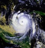
Hurricane Roxanne caused extensive flooding in Mexico
due to its erratic movement. The seventeenth storm, tenth hurricane, and the fifth and final major hurricane of the very active 1995 Atlantic hurricane season
, Roxanne developed in the southwestern Caribbean Sea from an area of low pressure on October 7. The depression curved northward, causing it to avoid landfall in Center America. By October 9, the depression intensified enough to be upgraded to Tropical Storm Roxanne. On the following day, Roxanne turned west-northward, where it promptly intensified into a hurricane. As Roxanne headed generally westward, it began to rapidly deepen, and reached Category 3 intensity less than 24 hours after becoming a hurricane. Shortly thereafter, Roxanne made landfall near Cozumel, Mexico at its peak intensity, which caused severe damage.
Roxanne rapidly weakened while traversing the Yucatan Peninsula
, and it emerged into the Bay of Campeche
on October 12, the storm was only a Category 1 hurricane. Further weakening occurred, and Roxanne was downgraded to a tropical storm later that day. Roxanne tracked northwestward and eventually re-intensified into a hurricane on October 14. Thereafter, Roxanne began to meander erratically in the Gulf of Mexico
; the storm turned abruptly southeastward, and remained nearly stationary offshore of the Yucatan Peninsula. Following day, Roxanne curved back northwestward and weakened back to a tropical storm on October 17. Roxanne completed a cyclonic loop across the Gulf of Mexico on October 18. Further weakening occurred, and Roxanne was downgraded to a tropical depression on October 19. A cold front in the Gulf of Mexico turned Roxanne abruptly southward, and the storm dissipated just offshore of Veracruz
on October 21.
Roxanne was the first October hurricane that formed and reached Category 3 intensity on the Saffir-Simpson Hurricane Scale
(SSHS) in the western Caribbean Sea since Hurricane Hattie
in October 1961. Due to its slow and erratic movement, Roxanne dropped heavy rainfall in many areas of southern Mexico, and some areas reported over 25 inches (635 mm) of precipitation. Heavy rainfall, in turn, lead to extensive flooding, which destroyed crop, washed out roads, and damaged at least 40,000 homes. In addition, significant coastal flooding also occurred, as storm surge for nearly a week caused water to travel inland for hundreds of yards. High winds also occurred over the Yucatan Peninsula, with one station reporting hurricane force winds on October 11. Overall, it is estimated that Roxanne caused $1.5 billion (1995 USD) in damage, although not all damage could be distinguished from Hurricane Opal
. In addition, 29 fatalities were reported.
. Although its development was complex, it is rather common in the western Caribbean. On October 6, data indicated that a broad low, a tropical wave, was well established near the Cayman Islands and Honduras. Satellite images indicated that the system was organizing and strengthening. All of these factors formed a tropical depression in the western Caribbean at 1800 UTC on October 7 near Nicaragua. At 0000 UTC on October 9, the depression became Tropical Storm Roxanne. Roxanne now posed a threat to the Cayman Islands
and Cuba
. However, the trough that was steering Roxanne to the north moved on and was replaced with a high pressure system. This system forced Roxanne west. As the storm moved towards the Yucatán
, it intensified greatly.
On October 10, Roxanne strengthened into a hurricane at 0600 UTC and had a well-developed eye. By 1200 UTC on October 10, the storm continued to strengthen and its pressure had fallen to 972 mb. Shortly after Roxanne reached hurricane strength, it rapidly intensified to Category 3 strength; this was the first time that had happened in the western Caribbean Sea
since the 1961 season
when Hurricane Hattie
took a very similar turn and intensification cycle. Roxanne reached her peak intensity with winds at 115 mph and pressure of 956 mb. Roxanne made landfall near peak intensity just north of Tulum, a small town near Cozumel, Mexico. Roxanne did not drop hurricane strength over land, despite the hurricane being inland for almost a full day and a half.
Roxanne emerged over water in the Bay of Campeche
as a minimal hurricane. Roxanne weakened to a tropical storm again shortly after exiting the coast, and turned northwest. As soon as the circulation was mostly over water, Roxanne became a hurricane again. Since steering currents over the southern Gulf were weak, Roxanne took an erratic and unusual path. Hurricane Roxanne trudged southeast, threatening the Yucatán again before turning northwest again. Roxanne steadily weakened, turned south, and finally dissipated near the southern end of the Bay of Campeche
.
for all of the islands. Several hours later, the government of Cuba issued a hurricane watch
and tropical storm warning for Pinar del Río
and the Isle of Youth. At the same time, the government of Mexico raised hurricane watches for coastal areas between Chetumal, Quintana Roo and Cabo Catoche
. Early on October 10, a hurricane warning
was declared for areas west of Cabo Catoche to Progreso, Yucatán
. By the afternoon, the hurricane watch was extended past Progreso to Ciudad del Carmen
. A new tropical storm warning was issued by the government of Belize that evening for areas north of Belize City
; however, this warning was discontinued early on October 11 as the center of Roxanne was not expected to pass near the area.
In the Yucatán Peninsula
, thousands of residents and tourists were urged to evacuate from coastal areas. In the city of Cancún
, roughly 12,000 tourists and 3,900 residents relocated to safer areas; however, some refused to leave and decided to wait out the storm in hotels. On Cozumel
, most hotel guests decided to ride out the storm instead of evacuate. There, most homeowners and businesses stored all lose items indoors and boarded up windows. An emergency alert was issued to hundreds of fishermen off the Yucatán coastline to move to port immediately. In the state of Campeche, 150 shelters were opened and able to accommodate roughly 15,000 people. However, more than 20,000 people sought refuge from the storm throughout the state.
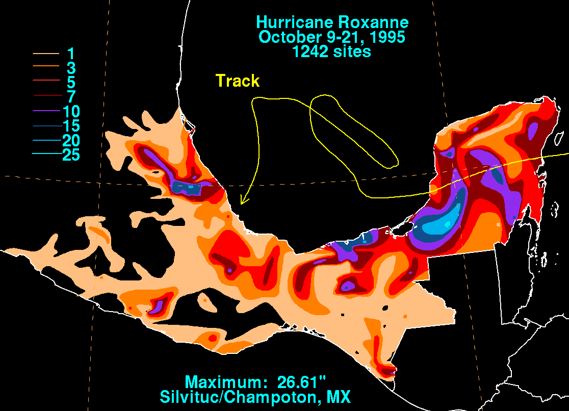 Roxanne caused 14 deaths, with five of them coming from the sinking of a petroleum work barge with 245 people on board. There was massive damage in Mexico across numerous Mexican states. Over forty thousand homes were damaged in the States of Campeche, Quintana Roo, Tabasco Veracruz and Yucatán. Crops were destroyed, cattle drowned, and roads were either washed out or blocked by mudslides. The road between the City of Carmen and Campeche was completely destroyed. There are unconfirmed reports that many hotel lobbies in Cancun and Cozumel were damaged from pounding waves. Rainfall and storm surge combined with overflowing rivers caused the worst flooding in Campeche since 1927. Rainfall in some areas was over 20 inches, with the highest rainfall reported as 26.61 inches/676 mm at Silvituc/Champoton. The storm surge also pounded the Mexican coastline for days and the Gulf waters surged inland hundreds of yards.
Roxanne caused the state owned Pemex
to shut down 90% of its drilling in the Gulf of Mexico during its pass as well as halt all shipments from three oil terminals in the southeastern region of the gulf. As a result, Mexico lost millions of dollars. Oil production dropped from 2.838 million barrels a day in September to 1.976 million barrels a day in October or 30.4%. (A rough guess using a price of the Maya Crude averaging about $13.77/b, 30 days in September, and 862,000 barrels a day of lost output yields $356 million, which in 2011 dollars equals about $530 million.) Oil production didn't completely recover in November, so there were some additional losses, but did completely return in December.
Throughout the state of Tabasco, nearly half of the highways sustained significant damage. Governor Roberto Madrazo Pintado estimated that it would cost roughly $60 million to repair them.
Roxanne struck an area that had been directly struck by Hurricane Opal
just a few weeks earlier and all damage could not be sorted out from Opal and Roxanne. Combined damage was estimated in the neighborhood of $1.5 billion.
and in the 2007 Atlantic hurricane season
, though Rebekah went unused during both hurricane seasons; it will next be in use for the 2013 season.
Mexico
The United Mexican States , commonly known as Mexico , is a federal constitutional republic in North America. It is bordered on the north by the United States; on the south and west by the Pacific Ocean; on the southeast by Guatemala, Belize, and the Caribbean Sea; and on the east by the Gulf of...
due to its erratic movement. The seventeenth storm, tenth hurricane, and the fifth and final major hurricane of the very active 1995 Atlantic hurricane season
1995 Atlantic hurricane season
The 1995 Atlantic hurricane season was the third most active Atlantic hurricane season on record. It officially began on June 1, 1995, and lasted until November 30, 1995. These dates conventionally delimit the period of each year when most tropical cyclones form in the north Atlantic ocean...
, Roxanne developed in the southwestern Caribbean Sea from an area of low pressure on October 7. The depression curved northward, causing it to avoid landfall in Center America. By October 9, the depression intensified enough to be upgraded to Tropical Storm Roxanne. On the following day, Roxanne turned west-northward, where it promptly intensified into a hurricane. As Roxanne headed generally westward, it began to rapidly deepen, and reached Category 3 intensity less than 24 hours after becoming a hurricane. Shortly thereafter, Roxanne made landfall near Cozumel, Mexico at its peak intensity, which caused severe damage.
Roxanne rapidly weakened while traversing the Yucatan Peninsula
Yucatán Peninsula
The Yucatán Peninsula, in southeastern Mexico, separates the Caribbean Sea from the Gulf of Mexico, with the northern coastline on the Yucatán Channel...
, and it emerged into the Bay of Campeche
Bay of Campeche
The Bay of Campeche is the southern bight of the Gulf of Mexico. It is surrounded on three sides by the Mexican states of Campeche, Tabasco and Veracruz. It was named by Francisco Hernández de Córdoba and Antonio de Alaminos during their expedition in 1517...
on October 12, the storm was only a Category 1 hurricane. Further weakening occurred, and Roxanne was downgraded to a tropical storm later that day. Roxanne tracked northwestward and eventually re-intensified into a hurricane on October 14. Thereafter, Roxanne began to meander erratically in the Gulf of Mexico
Gulf of Mexico
The Gulf of Mexico is a partially landlocked ocean basin largely surrounded by the North American continent and the island of Cuba. It is bounded on the northeast, north and northwest by the Gulf Coast of the United States, on the southwest and south by Mexico, and on the southeast by Cuba. In...
; the storm turned abruptly southeastward, and remained nearly stationary offshore of the Yucatan Peninsula. Following day, Roxanne curved back northwestward and weakened back to a tropical storm on October 17. Roxanne completed a cyclonic loop across the Gulf of Mexico on October 18. Further weakening occurred, and Roxanne was downgraded to a tropical depression on October 19. A cold front in the Gulf of Mexico turned Roxanne abruptly southward, and the storm dissipated just offshore of Veracruz
Veracruz
Veracruz, formally Veracruz de Ignacio de la Llave officially Estado Libre y Soberano de Veracruz de Ignacio de la Llave , is one of the 31 states that, along with the Federal District, comprise the 32 federative entities of Mexico. It is divided in 212 municipalities and its capital city is...
on October 21.
Roxanne was the first October hurricane that formed and reached Category 3 intensity on the Saffir-Simpson Hurricane Scale
Saffir-Simpson Hurricane Scale
The Saffir–Simpson Hurricane Scale , or the Saffir–Simpson Hurricane Wind Scale , classifies hurricanes — Western Hemisphere tropical cyclones that exceed the intensities of tropical depressions and tropical storms — into five categories distinguished by the intensities of their sustained winds...
(SSHS) in the western Caribbean Sea since Hurricane Hattie
Hurricane Hattie
Hurricane Hattie was the deadliest tropical cyclone of the 1961 Atlantic hurricane season, as well as the strongest, reaching a peak intensity equivalent to Category 5 hurricane intensity...
in October 1961. Due to its slow and erratic movement, Roxanne dropped heavy rainfall in many areas of southern Mexico, and some areas reported over 25 inches (635 mm) of precipitation. Heavy rainfall, in turn, lead to extensive flooding, which destroyed crop, washed out roads, and damaged at least 40,000 homes. In addition, significant coastal flooding also occurred, as storm surge for nearly a week caused water to travel inland for hundreds of yards. High winds also occurred over the Yucatan Peninsula, with one station reporting hurricane force winds on October 11. Overall, it is estimated that Roxanne caused $1.5 billion (1995 USD) in damage, although not all damage could be distinguished from Hurricane Opal
Hurricane Opal
Hurricane Opal was a Category 4 hurricane that formed in the Gulf of Mexico in September 1995.Opal was the ninth hurricane and the strongest of the abnormally active 1995 Atlantic hurricane season...
. In addition, 29 fatalities were reported.
Meteorological history
Roxanne formed from a tropical wave that merged with a broad low pressure area and an upper trough just off the coast of HondurasHonduras
Honduras is a republic in Central America. It was previously known as Spanish Honduras to differentiate it from British Honduras, which became the modern-day state of Belize...
. Although its development was complex, it is rather common in the western Caribbean. On October 6, data indicated that a broad low, a tropical wave, was well established near the Cayman Islands and Honduras. Satellite images indicated that the system was organizing and strengthening. All of these factors formed a tropical depression in the western Caribbean at 1800 UTC on October 7 near Nicaragua. At 0000 UTC on October 9, the depression became Tropical Storm Roxanne. Roxanne now posed a threat to the Cayman Islands
Cayman Islands
The Cayman Islands is a British Overseas Territory and overseas territory of the European Union located in the western Caribbean Sea. The territory comprises the three islands of Grand Cayman, Cayman Brac, and Little Cayman, located south of Cuba and northwest of Jamaica...
and Cuba
Cuba
The Republic of Cuba is an island nation in the Caribbean. The nation of Cuba consists of the main island of Cuba, the Isla de la Juventud, and several archipelagos. Havana is the largest city in Cuba and the country's capital. Santiago de Cuba is the second largest city...
. However, the trough that was steering Roxanne to the north moved on and was replaced with a high pressure system. This system forced Roxanne west. As the storm moved towards the Yucatán
Yucatán
Yucatán officially Estado Libre y Soberano de Yucatán is one of the 31 states which, with the Federal District, comprise the 32 Federal Entities of Mexico. It is divided in 106 municipalities and its capital city is Mérida....
, it intensified greatly.
On October 10, Roxanne strengthened into a hurricane at 0600 UTC and had a well-developed eye. By 1200 UTC on October 10, the storm continued to strengthen and its pressure had fallen to 972 mb. Shortly after Roxanne reached hurricane strength, it rapidly intensified to Category 3 strength; this was the first time that had happened in the western Caribbean Sea
Caribbean Sea
The Caribbean Sea is a sea of the Atlantic Ocean located in the tropics of the Western hemisphere. It is bounded by Mexico and Central America to the west and southwest, to the north by the Greater Antilles, and to the east by the Lesser Antilles....
since the 1961 season
1961 Atlantic hurricane season
The 1961 Atlantic hurricane season officially began on June 15, 1961, and lasted until November 15, 1961. These dates conventionally delimit the period of each year when most tropical cyclones form in the Atlantic basin. The season had seven major hurricanes, the second highest number on...
when Hurricane Hattie
Hurricane Hattie
Hurricane Hattie was the deadliest tropical cyclone of the 1961 Atlantic hurricane season, as well as the strongest, reaching a peak intensity equivalent to Category 5 hurricane intensity...
took a very similar turn and intensification cycle. Roxanne reached her peak intensity with winds at 115 mph and pressure of 956 mb. Roxanne made landfall near peak intensity just north of Tulum, a small town near Cozumel, Mexico. Roxanne did not drop hurricane strength over land, despite the hurricane being inland for almost a full day and a half.
Roxanne emerged over water in the Bay of Campeche
Bay of Campeche
The Bay of Campeche is the southern bight of the Gulf of Mexico. It is surrounded on three sides by the Mexican states of Campeche, Tabasco and Veracruz. It was named by Francisco Hernández de Córdoba and Antonio de Alaminos during their expedition in 1517...
as a minimal hurricane. Roxanne weakened to a tropical storm again shortly after exiting the coast, and turned northwest. As soon as the circulation was mostly over water, Roxanne became a hurricane again. Since steering currents over the southern Gulf were weak, Roxanne took an erratic and unusual path. Hurricane Roxanne trudged southeast, threatening the Yucatán again before turning northwest again. Roxanne steadily weakened, turned south, and finally dissipated near the southern end of the Bay of Campeche
Bay of Campeche
The Bay of Campeche is the southern bight of the Gulf of Mexico. It is surrounded on three sides by the Mexican states of Campeche, Tabasco and Veracruz. It was named by Francisco Hernández de Córdoba and Antonio de Alaminos during their expedition in 1517...
.
Preparations
Throughout Roxanne's existence, it continuously threatened land, prompting numerous watches and warnings across Mexico and nearby areas. Upon becoming a tropical storm on October 9, the government of the Cayman Islands declared a tropical storm warningTropical cyclone warnings and watches
Warnings and watches are two levels of alert issued by national weather forecasting bodies to coastal areas threatened by the imminent approach of a tropical cyclone of tropical storm or hurricane intensity. They are notices to the local population and civil authorities to make appropriate...
for all of the islands. Several hours later, the government of Cuba issued a hurricane watch
Tropical cyclone warnings and watches
Warnings and watches are two levels of alert issued by national weather forecasting bodies to coastal areas threatened by the imminent approach of a tropical cyclone of tropical storm or hurricane intensity. They are notices to the local population and civil authorities to make appropriate...
and tropical storm warning for Pinar del Río
Pinar del Río Province
Pinar del Río is one of the provinces of Cuba. It is at the western end of the island of Cuba.-Geography:The Pinar del Río province is Cuba's westernmost province and contains one of Cuba's three main mountain ranges, the Cordillera de Guaniguanico, divided into the easterly Sierra del Rosario and...
and the Isle of Youth. At the same time, the government of Mexico raised hurricane watches for coastal areas between Chetumal, Quintana Roo and Cabo Catoche
Cabo Catoche
Cabo Catoche or Cape Catoche, in the Mexican state of Quintana Roo, is the northernmost point on the Yucatán Peninsula. It lies in the municipality of Isla Mujeres, about north of the city of Cancún....
. Early on October 10, a hurricane warning
Tropical cyclone warnings and watches
Warnings and watches are two levels of alert issued by national weather forecasting bodies to coastal areas threatened by the imminent approach of a tropical cyclone of tropical storm or hurricane intensity. They are notices to the local population and civil authorities to make appropriate...
was declared for areas west of Cabo Catoche to Progreso, Yucatán
Progreso, Yucatán
Progreso is a port city in the Mexican state of Yucatán, located on the Gulf of Mexico in the north-west of the state some 30 minutes north of state capital Mérida by highway. As of the Mexican census of 2005, Progreso had an official population of 35,519 inhabitants, the fifth-largest community...
. By the afternoon, the hurricane watch was extended past Progreso to Ciudad del Carmen
Ciudad del Carmen
Ciudad del Carmen is a city in the southwest of the Mexican state of Campeche. Ciudad del Carmen is located at on the southwest of Carmen Island, which stands in the Laguna de Términos on the coast of the Gulf of Mexico. The 2005 census population was 154,197 people...
. A new tropical storm warning was issued by the government of Belize that evening for areas north of Belize City
Belize City
Belize City is the largest city in the Central American nation of Belize. Unofficial estimates place the population of Belize City at 70,000 or more. It is located at the mouth of the Belize River on the coast of the Caribbean. The city is the country's principal port and its financial and...
; however, this warning was discontinued early on October 11 as the center of Roxanne was not expected to pass near the area.
In the Yucatán Peninsula
Yucatán Peninsula
The Yucatán Peninsula, in southeastern Mexico, separates the Caribbean Sea from the Gulf of Mexico, with the northern coastline on the Yucatán Channel...
, thousands of residents and tourists were urged to evacuate from coastal areas. In the city of Cancún
Cancún
Cancún is a city of international tourism development certified by the UNWTO . Located on the northeast coast of Quintana Roo in southern Mexico, more than 1,700 km from Mexico City, the Project began operations in 1974 as Integrally Planned Center, a pioneer of FONATUR Cancún is a city of...
, roughly 12,000 tourists and 3,900 residents relocated to safer areas; however, some refused to leave and decided to wait out the storm in hotels. On Cozumel
Cozumel
Cozumel is an island in the Caribbean Sea off the eastern coast of Mexico's Yucatan Peninsula, opposite Playa del Carmen, and close to the Yucatan Channel. Cozumel is one of the ten municipalities of the state of Quintana Roo...
, most hotel guests decided to ride out the storm instead of evacuate. There, most homeowners and businesses stored all lose items indoors and boarded up windows. An emergency alert was issued to hundreds of fishermen off the Yucatán coastline to move to port immediately. In the state of Campeche, 150 shelters were opened and able to accommodate roughly 15,000 people. However, more than 20,000 people sought refuge from the storm throughout the state.
Impact
Roxanne caused the state owned Pemex
Pemex
Petróleos Mexicanos or Pemex is a Mexican state-owned petroleum company. As of 2010, with a total asset worth of $415.75 billion, it is the second non-publicly listed largest company in the world by total market value, and Latin America's second largest enterprise by annual revenue as of 2009...
to shut down 90% of its drilling in the Gulf of Mexico during its pass as well as halt all shipments from three oil terminals in the southeastern region of the gulf. As a result, Mexico lost millions of dollars. Oil production dropped from 2.838 million barrels a day in September to 1.976 million barrels a day in October or 30.4%. (A rough guess using a price of the Maya Crude averaging about $13.77/b, 30 days in September, and 862,000 barrels a day of lost output yields $356 million, which in 2011 dollars equals about $530 million.) Oil production didn't completely recover in November, so there were some additional losses, but did completely return in December.
Throughout the state of Tabasco, nearly half of the highways sustained significant damage. Governor Roberto Madrazo Pintado estimated that it would cost roughly $60 million to repair them.
Roxanne struck an area that had been directly struck by Hurricane Opal
Hurricane Opal
Hurricane Opal was a Category 4 hurricane that formed in the Gulf of Mexico in September 1995.Opal was the ninth hurricane and the strongest of the abnormally active 1995 Atlantic hurricane season...
just a few weeks earlier and all damage could not be sorted out from Opal and Roxanne. Combined damage was estimated in the neighborhood of $1.5 billion.
Retirement
Because of the major damage in Mexico, the name Roxanne was retired in the spring of 1996, and will never again be used for an Atlantic hurricane. It was replaced with Rebekah in the 2001 season2001 Atlantic hurricane season
The 2001 Atlantic hurricane season was a fairly active Atlantic hurricane season that produced 17 tropical cyclones, 15 named storms, nine hurricanes, and four major hurricanes. The season officially lasted from June 1, 2001, to November 30, 2001, dates which by convention limit the period of each...
and in the 2007 Atlantic hurricane season
2007 Atlantic hurricane season
The 2007 Atlantic hurricane season was an active Atlantic hurricane season that produced 17 tropical cyclones, 15 tropical storms, six hurricanes, and two major hurricanes. It officially started on June 1 and ended on November 30, dates which conventionally delimit the...
, though Rebekah went unused during both hurricane seasons; it will next be in use for the 2013 season.
See also
- List of Atlantic hurricanes
- List of retired Atlantic hurricane names
- Timeline of the 1995 Atlantic hurricane seasonTimeline of the 1995 Atlantic hurricane seasonThis timeline documents all the storm formations, strengthening, weakening, landfalls, extratropical transitions, as well as dissipation during the 1995 Atlantic hurricane season. The season officially began on June 1, 1995, and ended on November 30, and no storms formed off-season...