

Hurricane Luis
Encyclopedia
Hurricane Luis was one of the deadliest and most destructive hurricanes of the 1995 Atlantic hurricane season
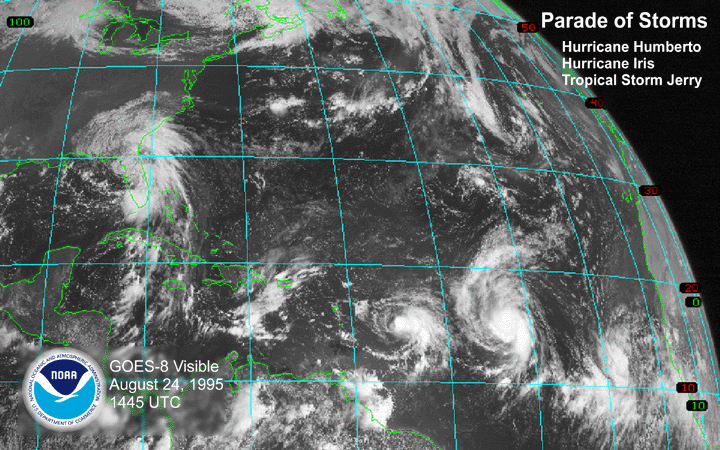
, with maximum sustained winds of 140 mph (220 km/h). The storm was the twelfth tropical storm, sixth hurricane, and second major hurricane of the season. Luis was also the strongest hurricane to make landfall, and the second most intense tropical cyclone recorded during the extremely active season. At one point, the storm was one of four simultaneous tropical systems in the Atlantic basin, along with Humberto
, Iris
, and Karen. The storm lasted for 15 days between late August and nearly middle September.
The system initially formed from a tropical wave
on August 27, and subsequently attained tropical storm status on August 29. Later that day, the storm reached hurricane status; shortly thereafter, it rapidly strengthening into a 140 mph (220 km/h) category 4 hurricane. At this strength, it affected much of the Leeward Islands
on September 4 to September 6. Throughout the following days, Luis entered a state of gradual weakening as it accelerated safely to the west of Bermuda
. As a category 1 hurricane, Luis made landfall on Newfoundland
before it ultimately became extratropical on September 11.
It caused catastrophic damage, especially in Antigua
, Barbuda
, St. Barthelemy, St Martin
and Anguilla
as a Category 4 with winds of 135 mph (215 km/h). The storm accounted for 19 deaths, left nearly 20,000 homeless (mostly in Antigua, Barbuda and Saint Martin) and wrought roughly $3 billion in damage across the affected areas. It was also held responsible for an intense rogue wave which struck RMS Queen Elizabeth 2
on Monday, September 11, though the ship pulled through with hardly any damage. Additionally, Luis was the second of three tropical cyclone
s to affect Guadeloupe
in a short period of time, the first being Hurricane Iris
a week before and the last being Hurricane Marilyn
only ten days afterward.
The next year, the Leeward Islands would be struck by Hurricane Bertha
, while still repairing from Luis and Marilyn, then successively hit by Hortense
, Erika
, Georges
, José
, Lenny
and Debby
.
over the eastern Atlantic Ocean
on August 26. A low-level circulation center formed and moved westward until it developed a weak surface low
on August 27; consequently, a tropical depression was designated at 1200 UTC that day. The depression attained 36 hours later into an Tropical Storm named "Luis" on August 29. Though convective activity fluctuated for the next two days as a result of nearby wind shear
, the storm slowly intensified while pressure rose. The shear relented the next day, allowing an eye
to gradually form, and the system attained hurricane status thereafter on early August 31 then a Category 3 major hurricane 18 hours later.
Hurricane Luis continued to strengthen as it tracked west-northwestward into a Category 4 on the Saffir-Simpson Hurricane Scale
on September 2 and the cyclone turned more towards the west earlier that day as it maintained a rectilinear slow motion. on September 3, a reconnaissance aircraft
confirmed that the storm, that reached Category 4 status earlier, peaked with 140 mph (225.3 km/h) and maintained it for two days and a half. At this time, it was located approximately 540 miles (869 km) to the east of the Lesser Antilles
. As a result, the storm grew as it moved along a subtropical ridge
due to the absorption of Karen by the stronger Iris
.
By the evening of September 4, Luis sustained a very large wind field with tropical storm-force winds extending outward up to 350 mi (563.3 km) of the center as it moved very near Antigua
and then directly passing over Barbuda
while weakened slightly on the morning of September 5. Islands such as Dominica
and even Guadeloupe
, where it experienced hurricane-force winds on the northeastern coast, has been relatively spared by the storm. During the time, it proceeded northwestward affecting Montserrat
, Saint Kitts and Nevis
, Sint Eustatius and Saba causing moderate damage. Later, Luis moved along St. Barthelemy, St. Martin and ultimately crossed Anguilla
, where maximum sustained winds within the eyewall were estimated to have reached 135 mph (217.3 km/h), and its central pressure had dropped from 945 to 942 mbar (27.9 to 27.8 inHg).
A large and powerful hurricane, Luis retained Category 4 intensity until September 7, situated about 150 mi (241.4 km) to the north of Puerto Rico
. The storm gradually re-curved over the northern Atlantic as a Category 2 after having spent 7 consecutive days as a major hurricane. From there on, the center of the storm passed 200 miles (321.9 km) to the west of Bermuda
on September 9 causing minor damage, and then later weakened to a Category 2 hurricane, with winds of 110 mph (165 km/h). Several hours later, the hurricane made its closest approach to Bermuda, passing about 200 mi (320 km) west of the island. Later that day, the storm began to accelerate as it traveled northeast ahead of a strong trough located to the northwest of Luis. During the afternoon of September 10, Hurricane Luis began to undergo an extratropical transition
as it rapidly approached the Canadian coastline. Due to the rapid movement of the storm, significant weakening did not occur until Luis was at an unusually high latitude as the central pressure of the storm decreased to 961 mbar (28.38 inHg) but sustained winds did not exceed 90 mph (140 km/h) according to the NHC.
Luis maintained this intensity until it made landfall on the Avalon Peninsula
in eastern Newfoundland early on September 11. While tracking over Newfoundland, cold, dry air became entrenched in Luis's circulation and the system began to merge with the approaching trough. The NHC issued their final advisory on Hurricane Luis at 0900 UTC on September 11 as it tracked nearly 65 mph (100 km/h) to the northeast and transitioned into an extratropical cyclone
on September 11 as it moved ashore on eastern Newfoundland. The extratropical remnants persisted for 30 more hours over the North Atlantic Ocean before being absorbed by the trough near the southern coast of Greenland
late on September 12.
and Saint Lucia
.
.
, though it is estimated at $3 billion (1995 USD).
and Barbuda
experienced extensive damage to residences from 135 mph winds and over 10 inches (254 mm) of rain. According to islands the Prime Minister, a great amount of houses were damaged or destroyed in Barbuda, and nearly 45% of the residences on Antigua were eradicated by the hurricane as it passed 25 miles (40.2 km) to the north of the island. Across the islands, numerous inhabitants experienced power outages and disrupted water systems. The storm ultimately accounted for three deaths and injured 165 locals; 32.000 inhabitants on both islands were greatly impact, forced 1,700 people to take shelter and left approximately 3,200 others homeless. Throughout the country, the total damage from the storm was estimated $350 million (1995 USD) or 60% of the country's GDP
worth of damage was assessed.
International aid was sought after the storm had made its passing, with shelter and food supplies being the most needed. Sanitary conditions worsened substantially, resulting in an increase of infectious mosquito plagues. However, the situation improved two weeks later as international facilities supplied financial support and aid, including $200,000 USD from France.
, essentially north of Grande-Terre
. Hurricane-force condition resulted in of moderate damage to homes and roofs, uprooted trees, and severe beach erosion. Meanwhile, the Basse-Terre
region received minor damage, except to banana crops that been damaged at nearly 100% and sugar cane crops on the north at nearly 20%. Additionally, 5 in (127 mm) to 11 in (279.4 mm) of rain were recorded in the islands while the mountains regions recorded up to 20 in (508 mm) as the highest rainfall was 22.91 in (581.9 mm) in La Grande Soufrière
within the 48-hour period, that damaged some roads specifically in the west coast where high waves washed houses and coastal road. The meteorological office in Raizet
recorded sustained winds of 53 mi/h with gusts reached 80 mi/h, reported a fall in minimal pressure to 994 mb (29.36 In Hg) around 3 to 4 am on September 5 and a total 95.6 mm (3.8 in) of rain during the whole period. Only the easternmost island Desirade, recorded a hurricane force-wind at 75 mi/h and a sustained gust at 84 mi/h between 3 and 4 on September 5 and a 990 mb (29.23 In Hg) pressure. The storm claimed the life of a 29-year-old French tourist, who had been dragged away by vigorous waves on a pier in Saint-François.
Followed by Hurricane Marilyn
, The total damage estimated at 250 millions of francs (50 millions USD), especially for the crops and the roads.
The island received the hardest condition of the eyewall as Luis passed 15 miles (24.1 km) to 20 miles (32.2 km) northeast of St. Martin, causing very extensive damage at 70% and spawning several F3
tornadoes. A total of 6.5 in (165.1 mm) of rain has been recorded on the island's territory during the 48 hours period.
In Grand Case bay, 90% of the houses were damaged or destroyed as a result of rough sea conditions and very strong winds. Damage was also common in other towns, such as Marigot
, French Quarter and Philipsburg, where at least 70% of the city was decimated by the storm. It also caused the Great Salt Pond to deluge several streets, leaving them partially submerged by 1 feet. Of the 1,500 boats sheltered in Simpson Bay Lagoon, nearly 1,300 or 85% were sunken or run aground. Furthermore, 7,000 were left people homeless (5,000 Haitians on their district in Marigot). At least 60% of the residences of the island's 50,000 people were damaged as nearly 20% of them were completely destroyed as some of them made uninhabitable, this is including businesses, churches, hotels (4 of them been destroyed), and schools. Some towns in the island spent nearly 3 months without water and power. Luis killed nine people (two in the French side and seven drowned in the Dutch side).
Princess Juliana Airport recorded 86 mi/h sustained winds with maximum gusts of 114 mi/h; the barometric pressure at its lowest fell between 964 to 963 mbar (28.5 to 28.4 inHg). The Met office on the French side (Grand Case airport
) of the island also measured a wind gust of 202 mph (325 km/h) while an unofficial anenometer in Marigot's "marina" recorded similar wind gusts. Tropical storm-force winds brushed the islands for approximately 24 to 36 hours, while hurricane-force winds lasted up to 12 hours as the hurricane passed with minimal forward speed between 6 mi/h to 9 mi/h. Total damages was astronomic, accounted for $1.8 billion (1995 USD) worth of damage. As such, Luis was the most devastating Hurricane to hit the islands since Hurricane Donna
in 1960.
. Although the island would have sustained worst damage than of St. Martin, total damage was still unknown. Luis was the worst hurricane the island suffered from 1960's Hurricane Donna
.
. The vegetation and some of the road infrastructure was badly damaged as a result of the storm, with problems essentially arising in relation to the poor water system. Total damage ultimately reached to $197 million (1995 USD).
was inflicted to banana crops, that been already damage from Iris
at 70%. While overall damages was fairly minor, beach erosion was common and that disrupt and washed few beach hotels and coastal roads, where about 1,000 people were left homeless, due to rough waves on the eastern and the northwestern coast of the island's town such as Marigot
and Portsmouth
. 40 miles (64.4 km) tropical Storm force-wind affected most part of the islands from the latest on September 4 until the morning of September 5 and lowest pressure recorded was between 1000 to 1005 mbar (29.5 to 29.7 inHg). Ultimately, a fisherman was confirmed killed due to rough sea conditions. All in all, property damage was estimated at $47 million; the storm contributed to the effects of Hurricane Iris
, which had struck the country a week before and Hurricane Marilyn
, 10 days after total at $184 million.
, causing minor damages in the east.
There were two deaths reports in the islands.
, eight homes were washed away by the waves and 40 feet (12.2 m) of beach was lost. In Hyde
, Carteret
, and Onslow
Counties, waves up to 17 feet (5.2 m) washed out 33 feet (10.1 m) of the Triple S Pier in Atlantic Beach was destroyed. Total losses in North Carolina amounted to $1.9 million (1995 USD). In New York, rough seas undermined one home, destroyed it and led to the death of one person who was swimming in the high waves.
On September 11, a rogue wave triggered by Luis slammed the Queen Elizabeth 2; though the ship did not sustain any significant damage, its arrival in New York was delayed considerably. In addition, a Canadian buoy also recorded extremely high waves along the coast.
 Throughout eastern Newfoundland, the system dropped 2.4 to 4.7 in (61 to 119.4 mm) of rainfall as it landfall as a Category 3. Northwesterly winds there gusted to 81 mph (130.4 km/h). The storm caused extensive damage to the large province. One storm-related death was reported in Canada. Flooding from Luis caused an estimated $500,000 in damages.
provided both Antigua and Barbuda and the Netherlands Antilles with $50,000 in emergency funds. Furthermore, the United Nations Development Programme
provided $50,000 for both Barbados and the Netherlands Antilles. For the reconstruction of schools, the United Nations Educational, Scientific and Cultural Organization
provided $20,000 to Antigua and Barbuda, $15,000 to Dominica, and $5,000 to St. Kitts and Nevis. The United Nations Children's Fund
provided a cash grant of $20,000 to all the affected islands. The European Community Humanitarian Aid Office provided relief goods, such as plastic sheeting, water containers, blankets, and basic medical supplies worth $1.2 million. The Organization of American States
provided an emergency cash grant of $250,000 for Antigua and Barbuda, Dominica, and St. Kitts and Nevis. The Government of Australia
provided Antigua and Barbuda with $37,593 in relief funds; the Government of the Bahamas provided $50,000 to the affected areas in emergency funds; the Government of Canada
donated $149,253 to the Pan American Health Organization
and $44,760 to the affected areas; the Government of France
contributed $200,000 in emergency funds to Antigua and Barbuda; the Government of Germany provided $52,817 in emergency funds to St. Kitts and Nevis; the Government of Jamaica deployed military recovery teams to affected regions to assist with rehabilitation and cleanup efforts; the Government of Japan
contributed $150,000 in emergency funds to the affected region; the Government of Norway provided $50,000 in cash assistance to Antigua and Barbuda and St. Kitts and Nevis; the Government of the Netherlands
provided $15.2 million in emergency funds and recovery funds to the Netherlands Antilles; the Government of New Zealand provided a cash assist of $32,942 to Antigua and Barbuda; the Government of Spain contributed $15,873 in emergency funds to the affected regions.
Whereas measurements on some hillside homes and especially the airport on the north of the French side, between two mountains, showed wind gusts between 170 and 205 mph (275 and 330 km/h). An sailor, that been sheltered in the lagoon recorded a 115 mph (185 km/h) winds gusting and a minimal pressure reading to 965 mbar (28.5 inHg).
 On September 11, a 98 feet (29.9 m) wave struck an ocean liner. This wave is the largest wave ever recorded; however, Hurricane Ivan
in 2004 may have produced a wave up to 130 feet (39.6 m) high off the coast of Mexico.
, the name "Luis" was retired in the spring of 1996, and will never again be used for an Atlantic hurricane. It was replaced with "Lorenzo" in the 2001 season
. Luis was the first L name to be retired since 1954, and was the first Atlantic hurricane name to be retired in three years since Hurricane Andrew
in 1992.
1995 Atlantic hurricane season
The 1995 Atlantic hurricane season was the third most active Atlantic hurricane season on record. It officially began on June 1, 1995, and lasted until November 30, 1995. These dates conventionally delimit the period of each year when most tropical cyclones form in the north Atlantic ocean...
, with maximum sustained winds of 140 mph (220 km/h). The storm was the twelfth tropical storm, sixth hurricane, and second major hurricane of the season. Luis was also the strongest hurricane to make landfall, and the second most intense tropical cyclone recorded during the extremely active season. At one point, the storm was one of four simultaneous tropical systems in the Atlantic basin, along with Humberto
Hurricane Humberto (1995)
Hurricane Humberto was the eighth named storm and fourth hurricane of the busy 1995 Atlantic hurricane season. This was the first time that the name "Humberto" was used as it replaced Hugo...
, Iris
Hurricane Iris (1995)
Hurricane Iris was the ninth named tropical cyclone and fifth hurricane of an active 1995 Atlantic hurricane season. Iris was one of four storms to form nearly simultaneously in the Atlantic during the 1995 season. Forming on August 22, Iris slowly drifted across the Leeward Islands as a tropical...
, and Karen. The storm lasted for 15 days between late August and nearly middle September.
The system initially formed from a tropical wave
Tropical wave
Tropical waves, easterly waves, or tropical easterly waves, also known as African easterly waves in the Atlantic region, are a type of atmospheric trough, an elongated area of relatively low air pressure, oriented north to south, which move from east to west across the tropics causing areas of...
on August 27, and subsequently attained tropical storm status on August 29. Later that day, the storm reached hurricane status; shortly thereafter, it rapidly strengthening into a 140 mph (220 km/h) category 4 hurricane. At this strength, it affected much of the Leeward Islands
Leeward Islands
The Leeward Islands are a group of islands in the West Indies. They are the northern islands of the Lesser Antilles chain. As a group they start east of Puerto Rico and reach southward to Dominica. They are situated where the northeastern Caribbean Sea meets the western Atlantic Ocean...
on September 4 to September 6. Throughout the following days, Luis entered a state of gradual weakening as it accelerated safely to the west of Bermuda
Bermuda
Bermuda is a British overseas territory in the North Atlantic Ocean. Located off the east coast of the United States, its nearest landmass is Cape Hatteras, North Carolina, about to the west-northwest. It is about south of Halifax, Nova Scotia, Canada, and northeast of Miami, Florida...
. As a category 1 hurricane, Luis made landfall on Newfoundland
Newfoundland and Labrador
Newfoundland and Labrador is the easternmost province of Canada. Situated in the country's Atlantic region, it incorporates the island of Newfoundland and mainland Labrador with a combined area of . As of April 2011, the province's estimated population is 508,400...
before it ultimately became extratropical on September 11.
It caused catastrophic damage, especially in Antigua
Antigua
Antigua , also known as Waladli, is an island in the West Indies, in the Leeward Islands in the Caribbean region, the main island of the country of Antigua and Barbuda. Antigua means "ancient" in Spanish and was named by Christopher Columbus after an icon in Seville Cathedral, Santa Maria de la...
, Barbuda
Barbuda
Barbuda is an island in the Eastern Caribbean, and forms part of the state of Antigua and Barbuda. It has a population of about 1,500, most of whom live in the town of Codrington.-Location:...
, St. Barthelemy, St Martin
Saint Martin
Saint Martin is an island in the northeast Caribbean, approximately east of Puerto Rico. The 87 km2 island is divided roughly 60/40 between France and the Kingdom of the Netherlands ; however, the Dutch side has the larger population. It is one of the smallest sea islands divided between...
and Anguilla
Anguilla
Anguilla is a British overseas territory and overseas territory of the European Union in the Caribbean. It is one of the most northerly of the Leeward Islands in the Lesser Antilles, lying east of Puerto Rico and the Virgin Islands and directly north of Saint Martin...
as a Category 4 with winds of 135 mph (215 km/h). The storm accounted for 19 deaths, left nearly 20,000 homeless (mostly in Antigua, Barbuda and Saint Martin) and wrought roughly $3 billion in damage across the affected areas. It was also held responsible for an intense rogue wave which struck RMS Queen Elizabeth 2
RMS Queen Elizabeth 2
Queen Elizabeth 2, often referred to simply as the QE2, is an ocean liner that was operated by Cunard from 1969 to 2008. Following her retirement from cruising, she is now owned by Istithmar...
on Monday, September 11, though the ship pulled through with hardly any damage. Additionally, Luis was the second of three tropical cyclone
Tropical cyclone
A tropical cyclone is a storm system characterized by a large low-pressure center and numerous thunderstorms that produce strong winds and heavy rain. Tropical cyclones strengthen when water evaporated from the ocean is released as the saturated air rises, resulting in condensation of water vapor...
s to affect Guadeloupe
Guadeloupe
Guadeloupe is an archipelago located in the Leeward Islands, in the Lesser Antilles, with a land area of 1,628 square kilometres and a population of 400,000. It is the first overseas region of France, consisting of a single overseas department. As with the other overseas departments, Guadeloupe...
in a short period of time, the first being Hurricane Iris
Hurricane Iris (1995)
Hurricane Iris was the ninth named tropical cyclone and fifth hurricane of an active 1995 Atlantic hurricane season. Iris was one of four storms to form nearly simultaneously in the Atlantic during the 1995 season. Forming on August 22, Iris slowly drifted across the Leeward Islands as a tropical...
a week before and the last being Hurricane Marilyn
Hurricane Marilyn
Hurricane Marilyn was the fifteenth tropical depression and thirteenth named storm of the unusually busy 1995 Atlantic hurricane season, following closely on the heels of Hurricane Luis. Hurricane Marilyn was the most powerful storm to hit the Virgin Islands since Hurricane Hugo of 1989.Marilyn...
only ten days afterward.
The next year, the Leeward Islands would be struck by Hurricane Bertha
Hurricane Bertha (1996)
Hurricane Bertha was a strong, early season major hurricane which impacted areas from the Leeward Islands to Atlantic Canada. Bertha originated from a tropical wave which moved off the eastern coast of Africa in early July. By July 3, an area of low pressure developed along the wave...
, while still repairing from Luis and Marilyn, then successively hit by Hortense
Hurricane Hortense
Hurricane Hortense was the eighth tropical storm, sixth hurricane, and second Category 4 hurricane of the 1996 Atlantic hurricane season. Lasting from September 3 to September 16, Hortense brought torrential flooding as it moved through the Lesser Antilles, Puerto Rico, and Dominican Republic...
, Erika
Hurricane Erika (1997)
Hurricane Erika was the strongest and longest-lasting tropical cyclone in the 1997 Atlantic hurricane season. Erika developed from a tropical wave on September 3 and moved west-northwestward across the tropical Atlantic Ocean; it steadily intensified until it attained hurricane status on September...
, Georges
Hurricane Georges
Hurricane Georges was a very destructive, powerful and long-lived Cape Verde-type Category 4 hurricane. Georges was the seventh tropical storm, fourth hurricane, and second major hurricane of the 1998 Atlantic hurricane season...
, José
Hurricane Jose (1999)
Hurricane Jose was a Category 2 hurricane that affected the Leeward Islands between October 20 and October 25, 1999. It was the tenth named storm, and eighth hurricane of the 1999 Atlantic hurricane season. Jose formed on October 17 while east of the Windward Islands. The storm quickly...
, Lenny
Hurricane Lenny
Hurricane Lenny was the strongest November Atlantic hurricane on record. It was the twelfth tropical storm, eighth hurricane, and record-breaking fifth Category 4 hurricane in the 1999 Atlantic hurricane season. Lenny formed on November 13 in the western Caribbean Sea, and maintained an...
and Debby
Hurricane Debby (2000)
Hurricane Debby was a minimal Category 1 hurricane that formed in mid-to-late August of the year 2000. Debby formed east of the Windward Islands on August 19, 2000, becoming the seventh tropical cyclone of the 2000 Atlantic hurricane season. The storm strengthened to a hurricane the next day,...
.
Meteorological history
The origins of Hurricane Luis trace back to an area of disturbed weather associated with a tropical waveTropical wave
Tropical waves, easterly waves, or tropical easterly waves, also known as African easterly waves in the Atlantic region, are a type of atmospheric trough, an elongated area of relatively low air pressure, oriented north to south, which move from east to west across the tropics causing areas of...
over the eastern Atlantic Ocean
Atlantic Ocean
The Atlantic Ocean is the second-largest of the world's oceanic divisions. With a total area of about , it covers approximately 20% of the Earth's surface and about 26% of its water surface area...
on August 26. A low-level circulation center formed and moved westward until it developed a weak surface low
Surface weather analysis
Surface weather analysis is a special type of weather map that provides a view of weather elements over a geographical area at a specified time based on information from ground-based weather stations...
on August 27; consequently, a tropical depression was designated at 1200 UTC that day. The depression attained 36 hours later into an Tropical Storm named "Luis" on August 29. Though convective activity fluctuated for the next two days as a result of nearby wind shear
Wind shear
Wind shear, sometimes referred to as windshear or wind gradient, is a difference in wind speed and direction over a relatively short distance in the atmosphere...
, the storm slowly intensified while pressure rose. The shear relented the next day, allowing an eye
Eye (cyclone)
The eye is a region of mostly calm weather found at the center of strong tropical cyclones. The eye of a storm is a roughly circular area and typically 30–65 km in diameter. It is surrounded by the eyewall, a ring of towering thunderstorms where the second most severe weather of a cyclone...
to gradually form, and the system attained hurricane status thereafter on early August 31 then a Category 3 major hurricane 18 hours later.
Hurricane Luis continued to strengthen as it tracked west-northwestward into a Category 4 on the Saffir-Simpson Hurricane Scale
Saffir-Simpson Hurricane Scale
The Saffir–Simpson Hurricane Scale , or the Saffir–Simpson Hurricane Wind Scale , classifies hurricanes — Western Hemisphere tropical cyclones that exceed the intensities of tropical depressions and tropical storms — into five categories distinguished by the intensities of their sustained winds...
on September 2 and the cyclone turned more towards the west earlier that day as it maintained a rectilinear slow motion. on September 3, a reconnaissance aircraft
Hurricane Hunters
The Hurricane Hunters are aircraft that fly into tropical cyclones in the North Atlantic Ocean and Northeastern Pacific Ocean for the specific purpose of directly measuring weather data in and around those storms. In the United States, the Air Force, Navy, and NOAA units have all participated in...
confirmed that the storm, that reached Category 4 status earlier, peaked with 140 mph (225.3 km/h) and maintained it for two days and a half. At this time, it was located approximately 540 miles (869 km) to the east of the Lesser Antilles
Lesser Antilles
The Lesser Antilles are a long, partly volcanic island arc in the Western Hemisphere. Most of its islands form the eastern boundary of the Caribbean Sea with the Atlantic Ocean, with the remainder located in the southern Caribbean just north of South America...
. As a result, the storm grew as it moved along a subtropical ridge
Subtropical ridge
The subtropical ridge is a significant belt of high pressure situated around the latitudes of 30°N in the Northern Hemisphere and 30°S in the Southern Hemisphere. It is characterized by mostly calm winds, which acts to reduce air quality under its axis by causing fog overnight, and haze during...
due to the absorption of Karen by the stronger Iris
Hurricane Iris (1995)
Hurricane Iris was the ninth named tropical cyclone and fifth hurricane of an active 1995 Atlantic hurricane season. Iris was one of four storms to form nearly simultaneously in the Atlantic during the 1995 season. Forming on August 22, Iris slowly drifted across the Leeward Islands as a tropical...
.
By the evening of September 4, Luis sustained a very large wind field with tropical storm-force winds extending outward up to 350 mi (563.3 km) of the center as it moved very near Antigua
Antigua
Antigua , also known as Waladli, is an island in the West Indies, in the Leeward Islands in the Caribbean region, the main island of the country of Antigua and Barbuda. Antigua means "ancient" in Spanish and was named by Christopher Columbus after an icon in Seville Cathedral, Santa Maria de la...
and then directly passing over Barbuda
Barbuda
Barbuda is an island in the Eastern Caribbean, and forms part of the state of Antigua and Barbuda. It has a population of about 1,500, most of whom live in the town of Codrington.-Location:...
while weakened slightly on the morning of September 5. Islands such as Dominica
Dominica
Dominica , officially the Commonwealth of Dominica, is an island nation in the Lesser Antilles region of the Caribbean Sea, south-southeast of Guadeloupe and northwest of Martinique. Its size is and the highest point in the country is Morne Diablotins, which has an elevation of . The Commonwealth...
and even Guadeloupe
Guadeloupe
Guadeloupe is an archipelago located in the Leeward Islands, in the Lesser Antilles, with a land area of 1,628 square kilometres and a population of 400,000. It is the first overseas region of France, consisting of a single overseas department. As with the other overseas departments, Guadeloupe...
, where it experienced hurricane-force winds on the northeastern coast, has been relatively spared by the storm. During the time, it proceeded northwestward affecting Montserrat
Montserrat
Montserrat is a British overseas territory located in the Leeward Islands, part of the chain of islands called the Lesser Antilles in the West Indies. This island measures approximately long and wide, giving of coastline...
, Saint Kitts and Nevis
Saint Kitts and Nevis
The Federation of Saint Kitts and Nevis , located in the Leeward Islands, is a federal two-island nation in the West Indies. It is the smallest sovereign state in the Americas, in both area and population....
, Sint Eustatius and Saba causing moderate damage. Later, Luis moved along St. Barthelemy, St. Martin and ultimately crossed Anguilla
Anguilla
Anguilla is a British overseas territory and overseas territory of the European Union in the Caribbean. It is one of the most northerly of the Leeward Islands in the Lesser Antilles, lying east of Puerto Rico and the Virgin Islands and directly north of Saint Martin...
, where maximum sustained winds within the eyewall were estimated to have reached 135 mph (217.3 km/h), and its central pressure had dropped from 945 to 942 mbar (27.9 to 27.8 inHg).
A large and powerful hurricane, Luis retained Category 4 intensity until September 7, situated about 150 mi (241.4 km) to the north of Puerto Rico
Puerto Rico
Puerto Rico , officially the Commonwealth of Puerto Rico , is an unincorporated territory of the United States, located in the northeastern Caribbean, east of the Dominican Republic and west of both the United States Virgin Islands and the British Virgin Islands.Puerto Rico comprises an...
. The storm gradually re-curved over the northern Atlantic as a Category 2 after having spent 7 consecutive days as a major hurricane. From there on, the center of the storm passed 200 miles (321.9 km) to the west of Bermuda
Bermuda
Bermuda is a British overseas territory in the North Atlantic Ocean. Located off the east coast of the United States, its nearest landmass is Cape Hatteras, North Carolina, about to the west-northwest. It is about south of Halifax, Nova Scotia, Canada, and northeast of Miami, Florida...
on September 9 causing minor damage, and then later weakened to a Category 2 hurricane, with winds of 110 mph (165 km/h). Several hours later, the hurricane made its closest approach to Bermuda, passing about 200 mi (320 km) west of the island. Later that day, the storm began to accelerate as it traveled northeast ahead of a strong trough located to the northwest of Luis. During the afternoon of September 10, Hurricane Luis began to undergo an extratropical transition
Extratropical cyclone
Extratropical cyclones, sometimes called mid-latitude cyclones or wave cyclones, are a group of cyclones defined as synoptic scale low pressure weather systems that occur in the middle latitudes of the Earth having neither tropical nor polar characteristics, and are connected with fronts and...
as it rapidly approached the Canadian coastline. Due to the rapid movement of the storm, significant weakening did not occur until Luis was at an unusually high latitude as the central pressure of the storm decreased to 961 mbar (28.38 inHg) but sustained winds did not exceed 90 mph (140 km/h) according to the NHC.
Luis maintained this intensity until it made landfall on the Avalon Peninsula
Avalon Peninsula
The Avalon Peninsula is a large peninsula that makes up the southeast portion of the island of Newfoundland.The peninsula is home to 257,223 people, which is approximately 51% of Newfoundland's population in 2009, and is the location of the provincial capital, St. John's. It is connected to the...
in eastern Newfoundland early on September 11. While tracking over Newfoundland, cold, dry air became entrenched in Luis's circulation and the system began to merge with the approaching trough. The NHC issued their final advisory on Hurricane Luis at 0900 UTC on September 11 as it tracked nearly 65 mph (100 km/h) to the northeast and transitioned into an extratropical cyclone
Extratropical cyclone
Extratropical cyclones, sometimes called mid-latitude cyclones or wave cyclones, are a group of cyclones defined as synoptic scale low pressure weather systems that occur in the middle latitudes of the Earth having neither tropical nor polar characteristics, and are connected with fronts and...
on September 11 as it moved ashore on eastern Newfoundland. The extratropical remnants persisted for 30 more hours over the North Atlantic Ocean before being absorbed by the trough near the southern coast of Greenland
Greenland
Greenland is an autonomous country within the Kingdom of Denmark, located between the Arctic and Atlantic Oceans, east of the Canadian Arctic Archipelago. Though physiographically a part of the continent of North America, Greenland has been politically and culturally associated with Europe for...
late on September 12.
Preparations
Hurricane Luis became a Category 4 hurricane several days before striking the Leeward Islands.Leeward Islands and Puerto Rico
Due to its slow motion, giving local officials ample time to prepare. In advance of the storm, tropical cyclone watches and warnings were declared in several areas throughout the Caribbean. Seventeen watches and/or warnings were issued in association with Luis. The first two were a Hurricane watch issued on Antigua, Barbuda and Guadeloupe on September 2 at 2200 UTC. Five hours later, a tropical storm watch was issued for Dominica. At 2100 UTC, a Hurricane Warning was issued for Antigua, Barbuda and a hurricane watch for Guadeloupe. At 1500 UTC, Puerto Rico was put under a tropical storm Watch. At 1700 UTC, Guadeloupe, St. Barthelemy, and French portion of St. Martin were put under a Hurricane Warning. Four hours later, Puerto Rico, U.S. and British Virgin Islands were put under a tropical storm warning, this is including MartiniqueMartinique
Martinique is an island in the eastern Caribbean Sea, with a land area of . Like Guadeloupe, it is an overseas region of France, consisting of a single overseas department. To the northwest lies Dominica, to the south St Lucia, and to the southeast Barbados...
and Saint Lucia
Saint Lucia
Saint Lucia is an island country in the eastern Caribbean Sea on the boundary with the Atlantic Ocean. Part of the Lesser Antilles, it is located north/northeast of the island of Saint Vincent, northwest of Barbados and south of Martinique. It covers a land area of 620 km2 and has an...
.
Bermuda and Canada
Additionally, a tropical storm warning was also issued for Bermuda on September 7, all of which were canceled by September 10. However, there were no tropical storm watches or warnings issued for any part of Atlantic CanadaAtlantic Canada
Atlantic Canada is the region of Canada comprising the four provinces located on the Atlantic coast, excluding Quebec: the three Maritime provinces – New Brunswick, Prince Edward Island, and Nova Scotia – and Newfoundland and Labrador...
.
Impact
| County/Region | Deaths | Damage | Source |
|---|---|---|---|
| Antigua and Barbuda Antigua and Barbuda Antigua and Barbuda is a twin-island nation lying between the Caribbean Sea and the Atlantic Ocean. It consists of two major inhabited islands, Antigua and Barbuda, and a number of smaller islands... |
3 | $350 million | |
| Guadeloupe Guadeloupe Guadeloupe is an archipelago located in the Leeward Islands, in the Lesser Antilles, with a land area of 1,628 square kilometres and a population of 400,000. It is the first overseas region of France, consisting of a single overseas department. As with the other overseas departments, Guadeloupe... |
1 | $50 million | |
| Dominica Dominica Dominica , officially the Commonwealth of Dominica, is an island nation in the Lesser Antilles region of the Caribbean Sea, south-southeast of Guadeloupe and northwest of Martinique. Its size is and the highest point in the country is Morne Diablotins, which has an elevation of . The Commonwealth... |
2 | $47 million | |
| Montserrat Montserrat Montserrat is a British overseas territory located in the Leeward Islands, part of the chain of islands called the Lesser Antilles in the West Indies. This island measures approximately long and wide, giving of coastline... |
0 | $20 million | |
| Saint Kitts and Nevis Saint Kitts and Nevis The Federation of Saint Kitts and Nevis , located in the Leeward Islands, is a federal two-island nation in the West Indies. It is the smallest sovereign state in the Americas, in both area and population.... |
0 | $197 million | |
| Saint Martin Saint Martin Saint Martin is an island in the northeast Caribbean, approximately east of Puerto Rico. The 87 km2 island is divided roughly 60/40 between France and the Kingdom of the Netherlands ; however, the Dutch side has the larger population. It is one of the smallest sea islands divided between... |
9 | $1.8 billion | |
| Puerto Rico Puerto Rico Puerto Rico , officially the Commonwealth of Puerto Rico , is an unincorporated territory of the United States, located in the northeastern Caribbean, east of the Dominican Republic and west of both the United States Virgin Islands and the British Virgin Islands.Puerto Rico comprises an... |
2 | $200 million | |
| United States United States The United States of America is a federal constitutional republic comprising fifty states and a federal district... |
1 | $1.9 million | |
| U.S. Virgin Islands United States Virgin Islands The Virgin Islands of the United States are a group of islands in the Caribbean that are an insular area of the United States. The islands are geographically part of the Virgin Islands archipelago and are located in the Leeward Islands of the Lesser Antilles.The U.S... |
0 | $300 million | |
| Newfoundland | 1 | $0.5 million | |
| Total | 19 | ~$3 billion |
Leeward Islands
Overall, Luis caused extensive crop and property damage across the Leeward Islands due to its high associated powerful winds and heavy rainfall. The exact amount of damage caused by the storm is unknown due to lack of reports from impacted areas since IrisHurricane Iris (1995)
Hurricane Iris was the ninth named tropical cyclone and fifth hurricane of an active 1995 Atlantic hurricane season. Iris was one of four storms to form nearly simultaneously in the Atlantic during the 1995 season. Forming on August 22, Iris slowly drifted across the Leeward Islands as a tropical...
, though it is estimated at $3 billion (1995 USD).
Antigua and Barbuda
As a result of a direct hit from the Category 4 hurricane, both AntiguaAntigua
Antigua , also known as Waladli, is an island in the West Indies, in the Leeward Islands in the Caribbean region, the main island of the country of Antigua and Barbuda. Antigua means "ancient" in Spanish and was named by Christopher Columbus after an icon in Seville Cathedral, Santa Maria de la...
and Barbuda
Barbuda
Barbuda is an island in the Eastern Caribbean, and forms part of the state of Antigua and Barbuda. It has a population of about 1,500, most of whom live in the town of Codrington.-Location:...
experienced extensive damage to residences from 135 mph winds and over 10 inches (254 mm) of rain. According to islands the Prime Minister, a great amount of houses were damaged or destroyed in Barbuda, and nearly 45% of the residences on Antigua were eradicated by the hurricane as it passed 25 miles (40.2 km) to the north of the island. Across the islands, numerous inhabitants experienced power outages and disrupted water systems. The storm ultimately accounted for three deaths and injured 165 locals; 32.000 inhabitants on both islands were greatly impact, forced 1,700 people to take shelter and left approximately 3,200 others homeless. Throughout the country, the total damage from the storm was estimated $350 million (1995 USD) or 60% of the country's GDP
Gross domestic product
Gross domestic product refers to the market value of all final goods and services produced within a country in a given period. GDP per capita is often considered an indicator of a country's standard of living....
worth of damage was assessed.
International aid was sought after the storm had made its passing, with shelter and food supplies being the most needed. Sanitary conditions worsened substantially, resulting in an increase of infectious mosquito plagues. However, the situation improved two weeks later as international facilities supplied financial support and aid, including $200,000 USD from France.
Guadeloupe
Luis caused some damage as it passed 60 miles (96.6 km) north of GuadeloupeGuadeloupe
Guadeloupe is an archipelago located in the Leeward Islands, in the Lesser Antilles, with a land area of 1,628 square kilometres and a population of 400,000. It is the first overseas region of France, consisting of a single overseas department. As with the other overseas departments, Guadeloupe...
, essentially north of Grande-Terre
Grande-Terre
Grande-Terre is an island in the Guadeloupe, separated by Basse-Terre Island by a salt river. Grande-Terre's northernmost point, Pointe de la Grande Vigie, is also the northernmost point in Guadeloupe....
. Hurricane-force condition resulted in of moderate damage to homes and roofs, uprooted trees, and severe beach erosion. Meanwhile, the Basse-Terre
Basse-Terre
Basse-Terre is the prefecture of Guadeloupe, an overseas region and department of France located in the Lesser Antilles...
region received minor damage, except to banana crops that been damaged at nearly 100% and sugar cane crops on the north at nearly 20%. Additionally, 5 in (127 mm) to 11 in (279.4 mm) of rain were recorded in the islands while the mountains regions recorded up to 20 in (508 mm) as the highest rainfall was 22.91 in (581.9 mm) in La Grande Soufrière
La Grande Soufrière
La Grande Soufrière, , is an active stratovolcano located on the French island of Basse-Terre, in Guadeloupe. It is the tallest mountain in the Lesser Antilles, and rises 1,467 m high....
within the 48-hour period, that damaged some roads specifically in the west coast where high waves washed houses and coastal road. The meteorological office in Raizet
Pointe-à-Pitre International Airport
Pointe-à-Pitre International Airport or Pointe-à-Pitre Le Raizet Airport is an airport serving Pointe-à-Pitre on the island of Grande-Terre in Guadeloupe. The airport is located in Abymes, north-northeast of Pointe-à-Pitre. It is the main hub for Air Caraïbes and Air Antilles Express. It is the...
recorded sustained winds of 53 mi/h with gusts reached 80 mi/h, reported a fall in minimal pressure to 994 mb (29.36 In Hg) around 3 to 4 am on September 5 and a total 95.6 mm (3.8 in) of rain during the whole period. Only the easternmost island Desirade, recorded a hurricane force-wind at 75 mi/h and a sustained gust at 84 mi/h between 3 and 4 on September 5 and a 990 mb (29.23 In Hg) pressure. The storm claimed the life of a 29-year-old French tourist, who had been dragged away by vigorous waves on a pier in Saint-François.
Followed by Hurricane Marilyn
Hurricane Marilyn
Hurricane Marilyn was the fifteenth tropical depression and thirteenth named storm of the unusually busy 1995 Atlantic hurricane season, following closely on the heels of Hurricane Luis. Hurricane Marilyn was the most powerful storm to hit the Virgin Islands since Hurricane Hugo of 1989.Marilyn...
, The total damage estimated at 250 millions of francs (50 millions USD), especially for the crops and the roads.
St. Martin
| Wettest tropical cyclones in St. Martin/Maarten Highest known recorded totals |
||||
|---|---|---|---|---|
| Precipitation | Storm | Measurement station |
||
| Rank | (mm) | (in) | ||
| 1 | 866.6 mm | 34.12 inches | Lenny 1999 Hurricane Lenny Hurricane Lenny was the strongest November Atlantic hurricane on record. It was the twelfth tropical storm, eighth hurricane, and record-breaking fifth Category 4 hurricane in the 1999 Atlantic hurricane season. Lenny formed on November 13 in the western Caribbean Sea, and maintained an... |
|
| 2 | 349.3 mm | 13.75 inches | Jose 1999 Hurricane Jose (1999) Hurricane Jose was a Category 2 hurricane that affected the Leeward Islands between October 20 and October 25, 1999. It was the tenth named storm, and eighth hurricane of the 1999 Atlantic hurricane season. Jose formed on October 17 while east of the Windward Islands. The storm quickly... |
|
| 3 | 300.1 mm | 12.00 inches | Otto 2010 Hurricane Otto (2010) Hurricane Otto was a moderate Category 1 storm that caused widespread damage in portions of the northeastern Caribbean islands. Otto originated as a subtropical cyclone north of Puerto Rico on October 6, and transitioned into a tropical storm the next day, the fifteenth of the season... |
|
| 4 | 165.1 mm | 6.50 inches | Luis 1995 | |
| 5 | 98 mm | 3.85 inches | Earl 2010 Hurricane Earl The name Earl has been used for six tropical cyclones in the Atlantic Ocean.* Hurricane Earl — drifted over the central Atlantic Ocean without affecting land* Hurricane Earl — drifted over the central Atlantic Ocean without affecting land... |
Grand Case |
| 6 | 85.1 mm | 3.35 inches | Marilyn 1995 Hurricane Marilyn Hurricane Marilyn was the fifteenth tropical depression and thirteenth named storm of the unusually busy 1995 Atlantic hurricane season, following closely on the heels of Hurricane Luis. Hurricane Marilyn was the most powerful storm to hit the Virgin Islands since Hurricane Hugo of 1989.Marilyn... |
|
The island received the hardest condition of the eyewall as Luis passed 15 miles (24.1 km) to 20 miles (32.2 km) northeast of St. Martin, causing very extensive damage at 70% and spawning several F3
Fujita scale
The Fujita scale , or Fujita-Pearson scale, is a scale for rating tornado intensity, based primarily on the damage tornadoes inflict on human-built structures and vegetation...
tornadoes. A total of 6.5 in (165.1 mm) of rain has been recorded on the island's territory during the 48 hours period.
In Grand Case bay, 90% of the houses were damaged or destroyed as a result of rough sea conditions and very strong winds. Damage was also common in other towns, such as Marigot
Marigot, Saint Martin
Marigot is the main town and capital on the French side of the Caribbean island of Saint Martin.-History and features:Originally a fishing village on a swamp for which it was named, Marigot was made capital during the reign of King Louis XVI, who built Fort St. Louis on a hill near Marigot Bay...
, French Quarter and Philipsburg, where at least 70% of the city was decimated by the storm. It also caused the Great Salt Pond to deluge several streets, leaving them partially submerged by 1 feet. Of the 1,500 boats sheltered in Simpson Bay Lagoon, nearly 1,300 or 85% were sunken or run aground. Furthermore, 7,000 were left people homeless (5,000 Haitians on their district in Marigot). At least 60% of the residences of the island's 50,000 people were damaged as nearly 20% of them were completely destroyed as some of them made uninhabitable, this is including businesses, churches, hotels (4 of them been destroyed), and schools. Some towns in the island spent nearly 3 months without water and power. Luis killed nine people (two in the French side and seven drowned in the Dutch side).
Princess Juliana Airport recorded 86 mi/h sustained winds with maximum gusts of 114 mi/h; the barometric pressure at its lowest fell between 964 to 963 mbar (28.5 to 28.4 inHg). The Met office on the French side (Grand Case airport
L'Espérance Airport
L'Espérance Airport , also known as Grand Case Airport , is a public use airport located in Grand Case, on the French side of the Caribbean island of Saint Martin...
) of the island also measured a wind gust of 202 mph (325 km/h) while an unofficial anenometer in Marigot's "marina" recorded similar wind gusts. Tropical storm-force winds brushed the islands for approximately 24 to 36 hours, while hurricane-force winds lasted up to 12 hours as the hurricane passed with minimal forward speed between 6 mi/h to 9 mi/h. Total damages was astronomic, accounted for $1.8 billion (1995 USD) worth of damage. As such, Luis was the most devastating Hurricane to hit the islands since Hurricane Donna
Hurricane Donna
Hurricane Donna in the 1960 Atlantic hurricane season was a Cape Verde-type hurricane which moved across the Leeward Islands, Puerto Rico, Hispanola, Cuba, The Bahamas, and every state on the East Coast of the United States...
in 1960.
Anguilla
The eye of the hurricane past on the northeastern tip of AnguillaAnguilla
Anguilla is a British overseas territory and overseas territory of the European Union in the Caribbean. It is one of the most northerly of the Leeward Islands in the Lesser Antilles, lying east of Puerto Rico and the Virgin Islands and directly north of Saint Martin...
. Although the island would have sustained worst damage than of St. Martin, total damage was still unknown. Luis was the worst hurricane the island suffered from 1960's Hurricane Donna
Hurricane Donna
Hurricane Donna in the 1960 Atlantic hurricane season was a Cape Verde-type hurricane which moved across the Leeward Islands, Puerto Rico, Hispanola, Cuba, The Bahamas, and every state on the East Coast of the United States...
.
St. Barthelemy
The islands suffered extensive damages from 135 mph (215 km/h) winds as the hurricane passed 155 miles (25 km) north of Saint Barthelemy. The main weather station recorded wind speeds of 125 mph (200 km/h) and gusts of up to 155 mph (250 km/h); this difference may be due to local effects produced by mountainous terrain on the island and the aircraft sampling winds at a level above the region of maximum winds. Additionally, minimal recorded pressure was at 948 mbar (28 inHg) as the storm made its closest approach and stay below 1000 mbar (29.5 inHg) for at least 365 hours period.St. Kitts and Nevis
Luis passed nearly 50 miles (80.5 km) northeast that caused very severe beach erosion, moderate damage to residences and leaving at least 2,000 homeless on Saint Kitts and NevisSaint Kitts and Nevis
The Federation of Saint Kitts and Nevis , located in the Leeward Islands, is a federal two-island nation in the West Indies. It is the smallest sovereign state in the Americas, in both area and population....
. The vegetation and some of the road infrastructure was badly damaged as a result of the storm, with problems essentially arising in relation to the poor water system. Total damage ultimately reached to $197 million (1995 USD).
Dominica
As Luis passed at 121 miles (194.7 km) north, majority of the damage experienced in DominicaDominica
Dominica , officially the Commonwealth of Dominica, is an island nation in the Lesser Antilles region of the Caribbean Sea, south-southeast of Guadeloupe and northwest of Martinique. Its size is and the highest point in the country is Morne Diablotins, which has an elevation of . The Commonwealth...
was inflicted to banana crops, that been already damage from Iris
Hurricane Iris (1995)
Hurricane Iris was the ninth named tropical cyclone and fifth hurricane of an active 1995 Atlantic hurricane season. Iris was one of four storms to form nearly simultaneously in the Atlantic during the 1995 season. Forming on August 22, Iris slowly drifted across the Leeward Islands as a tropical...
at 70%. While overall damages was fairly minor, beach erosion was common and that disrupt and washed few beach hotels and coastal roads, where about 1,000 people were left homeless, due to rough waves on the eastern and the northwestern coast of the island's town such as Marigot
Marigot, Dominica
Marigot is the largest settlement of Saint Andrew Parish in northeastern Dominica. The village has a population of 2,676 people, and is home to a Fisheries Complex as well as the island's main airport. It is the birthplace of local politician Edison James, and cricket umpire Billy...
and Portsmouth
Portsmouth, Dominica
Portsmouth is the second largest town in Dominica, with 2,977 inhabitants. It lies on the Indian River on Dominica's northwest coast, in Saint John Parish. Cabrits National Park is located on a peninsula to the north of town. Portsmouth has its own sea port in Prince Rupert Bay.Portsmouth was...
. 40 miles (64.4 km) tropical Storm force-wind affected most part of the islands from the latest on September 4 until the morning of September 5 and lowest pressure recorded was between 1000 to 1005 mbar (29.5 to 29.7 inHg). Ultimately, a fisherman was confirmed killed due to rough sea conditions. All in all, property damage was estimated at $47 million; the storm contributed to the effects of Hurricane Iris
Hurricane Iris (1995)
Hurricane Iris was the ninth named tropical cyclone and fifth hurricane of an active 1995 Atlantic hurricane season. Iris was one of four storms to form nearly simultaneously in the Atlantic during the 1995 season. Forming on August 22, Iris slowly drifted across the Leeward Islands as a tropical...
, which had struck the country a week before and Hurricane Marilyn
Hurricane Marilyn
Hurricane Marilyn was the fifteenth tropical depression and thirteenth named storm of the unusually busy 1995 Atlantic hurricane season, following closely on the heels of Hurricane Luis. Hurricane Marilyn was the most powerful storm to hit the Virgin Islands since Hurricane Hugo of 1989.Marilyn...
, 10 days after total at $184 million.
Puerto Rico
Luis passed at 125 miles (201.2 km) northeast of Puerto RicoPuerto Rico
Puerto Rico , officially the Commonwealth of Puerto Rico , is an unincorporated territory of the United States, located in the northeastern Caribbean, east of the Dominican Republic and west of both the United States Virgin Islands and the British Virgin Islands.Puerto Rico comprises an...
, causing minor damages in the east.
There were two deaths reports in the islands.
Bermuda
Bermuda reported sustained winds of 46 miles per hour (74 km/h); however, little to no damage has been reported. Offshore, the storm produced waves approaching 100 feet (30.5 m) in height.Eastern United States and offshore
Rough seas from the storm affected the U.S. East Coast, resulting in some beach erosion and damage to two waterfront structures on Fire Island. On September 7, rip currents produced by Luis caused the death of one person near Corncake Inlet, North Carolina. High waves, in combination with high tide, caused significant beach erosion and coastal flooding. In Brunswick CountyBrunswick County, North Carolina
-External links:*******....
, eight homes were washed away by the waves and 40 feet (12.2 m) of beach was lost. In Hyde
Hyde County, North Carolina
-National protected areas:* Alligator River National Wildlife Refuge * Cape Hatteras National Seashore * Mattamuskeet National Wildlife Refuge* Pocosin Lakes National Wildlife Refuge * Swanquarter National Wildlife Refuge-Demographics:...
, Carteret
Carteret County, North Carolina
Carteret County is a county located in the U.S. state of North Carolina. As of 2010, the population was 66,469. Its county seat is Beaufort. Most of the county is part of the Crystal Coast....
, and Onslow
Onslow County, North Carolina
-Demographics:As of the census of 2000, there were 150,355 people, 48,122 households, and 36,572 families residing in the county. The population density was 196 people per square mile . There were 55,726 housing units at an average density of 73 per square mile...
Counties, waves up to 17 feet (5.2 m) washed out 33 feet (10.1 m) of the Triple S Pier in Atlantic Beach was destroyed. Total losses in North Carolina amounted to $1.9 million (1995 USD). In New York, rough seas undermined one home, destroyed it and led to the death of one person who was swimming in the high waves.
On September 11, a rogue wave triggered by Luis slammed the Queen Elizabeth 2; though the ship did not sustain any significant damage, its arrival in New York was delayed considerably. In addition, a Canadian buoy also recorded extremely high waves along the coast.
Atlantic Canada
Antigua, Barbuda, Dominica and St. Kitts and Nevis
By September 29, the Office for the Coordination of Humanitarian AffairsOffice for the Coordination of Humanitarian Affairs
The United Nations Office for the Coordination of Humanitarian Affairs , is a United Nations body formed in December 1991 by General Assembly Resolution 46/182...
provided both Antigua and Barbuda and the Netherlands Antilles with $50,000 in emergency funds. Furthermore, the United Nations Development Programme
United Nations Development Programme
The United Nations Development Programme is the United Nations' global development network. It advocates for change and connects countries to knowledge, experience and resources to help people build a better life. UNDP operates in 177 countries, working with nations on their own solutions to...
provided $50,000 for both Barbados and the Netherlands Antilles. For the reconstruction of schools, the United Nations Educational, Scientific and Cultural Organization
UNESCO
The United Nations Educational, Scientific and Cultural Organization is a specialized agency of the United Nations...
provided $20,000 to Antigua and Barbuda, $15,000 to Dominica, and $5,000 to St. Kitts and Nevis. The United Nations Children's Fund
United Nations Children's Fund
United Nations Children's Fund was created by the United Nations General Assembly on December 11, 1946, to provide emergency food and healthcare to children in countries that had been devastated by World War II...
provided a cash grant of $20,000 to all the affected islands. The European Community Humanitarian Aid Office provided relief goods, such as plastic sheeting, water containers, blankets, and basic medical supplies worth $1.2 million. The Organization of American States
Organization of American States
The Organization of American States is a regional international organization, headquartered in Washington, D.C., United States...
provided an emergency cash grant of $250,000 for Antigua and Barbuda, Dominica, and St. Kitts and Nevis. The Government of Australia
Government of Australia
The Commonwealth of Australia is a federal constitutional monarchy under a parliamentary democracy. The Commonwealth of Australia was formed in 1901 as a result of an agreement among six self-governing British colonies, which became the six states...
provided Antigua and Barbuda with $37,593 in relief funds; the Government of the Bahamas provided $50,000 to the affected areas in emergency funds; the Government of Canada
Government of Canada
The Government of Canada, formally Her Majesty's Government, is the system whereby the federation of Canada is administered by a common authority; in Canadian English, the term can mean either the collective set of institutions or specifically the Queen-in-Council...
donated $149,253 to the Pan American Health Organization
Pan American Health Organization
The Pan American Health Organization is an international public health agency with over 100 years of experience working to improve health and living standards of the people of the Americas...
and $44,760 to the affected areas; the Government of France
Government of France
The government of the French Republic is a semi-presidential system determined by the French Constitution of the fifth Republic. The nation declares itself to be an "indivisible, secular, democratic, and social Republic"...
contributed $200,000 in emergency funds to Antigua and Barbuda; the Government of Germany provided $52,817 in emergency funds to St. Kitts and Nevis; the Government of Jamaica deployed military recovery teams to affected regions to assist with rehabilitation and cleanup efforts; the Government of Japan
Government of Japan
The government of Japan is a constitutional monarchy where the power of the Emperor is very limited. As a ceremonial figurehead, he is defined by the 1947 constitution as "the symbol of the state and of the unity of the people". Power is held chiefly by the Prime Minister of Japan and other elected...
contributed $150,000 in emergency funds to the affected region; the Government of Norway provided $50,000 in cash assistance to Antigua and Barbuda and St. Kitts and Nevis; the Government of the Netherlands
Cabinet of the Netherlands
The cabinet of the Netherlands is the main executive body of the Dutch government. The current cabinet of the Netherlands is the Rutte cabinet.-Composition and role:...
provided $15.2 million in emergency funds and recovery funds to the Netherlands Antilles; the Government of New Zealand provided a cash assist of $32,942 to Antigua and Barbuda; the Government of Spain contributed $15,873 in emergency funds to the affected regions.
Saint Martin
Aside from high winds and seas, possible explanation for the storm's heavy damage may have been complacency on the part of local island populations. Another factual reason was substantial difference in wind speed forecasts measured at sea-level, Princess Juliana Airport on St. Martin and those measured on homes throughout the Island hillsides & broadcast from sites off the island. Sea-level Airport readings showed 86 mph (138 km/h) sustained winds and winds gusting to 114 mph (184 km/h).Whereas measurements on some hillside homes and especially the airport on the north of the French side, between two mountains, showed wind gusts between 170 and 205 mph (275 and 330 km/h). An sailor, that been sheltered in the lagoon recorded a 115 mph (185 km/h) winds gusting and a minimal pressure reading to 965 mbar (28.5 inHg).
Records
Hurricane Ivan
Hurricane Ivan was a large, long-lived, Cape Verde-type hurricane that caused widespread damage in the Caribbean and United States. The cyclone was the ninth named storm, the sixth hurricane and the fourth major hurricane of the active 2004 Atlantic hurricane season...
in 2004 may have produced a wave up to 130 feet (39.6 m) high off the coast of Mexico.
Retirement
Due to the very severe devastating impacts and loss of life caused in the Leeward IslandsLeeward Islands
The Leeward Islands are a group of islands in the West Indies. They are the northern islands of the Lesser Antilles chain. As a group they start east of Puerto Rico and reach southward to Dominica. They are situated where the northeastern Caribbean Sea meets the western Atlantic Ocean...
, the name "Luis" was retired in the spring of 1996, and will never again be used for an Atlantic hurricane. It was replaced with "Lorenzo" in the 2001 season
2001 Atlantic hurricane season
The 2001 Atlantic hurricane season was a fairly active Atlantic hurricane season that produced 17 tropical cyclones, 15 named storms, nine hurricanes, and four major hurricanes. The season officially lasted from June 1, 2001, to November 30, 2001, dates which by convention limit the period of each...
. Luis was the first L name to be retired since 1954, and was the first Atlantic hurricane name to be retired in three years since Hurricane Andrew
Hurricane Andrew
Hurricane Andrew was the third Category 5 hurricane to make landfall in the United States, after the Labor Day Hurricane of 1935 and Hurricane Camille in 1969. Andrew was the first named storm and only major hurricane of the otherwise inactive 1992 Atlantic hurricane season...
in 1992.
See also
- List of tropical cyclones
- List of Atlantic hurricanes
- Timeline of the 1995 Atlantic hurricane seasonTimeline of the 1995 Atlantic hurricane seasonThis timeline documents all the storm formations, strengthening, weakening, landfalls, extratropical transitions, as well as dissipation during the 1995 Atlantic hurricane season. The season officially began on June 1, 1995, and ended on November 30, and no storms formed off-season...