
1953 Atlantic hurricane season
Encyclopedia
The 1953 Atlantic hurricane season was the first time an organized list of female names was used to name Atlantic storms. It officially began on June 15, and lasted until November 15, although activity occurred both before and after the season
's limits. It is one of only four seasons to have a pre-season storm and a post-season storm, the others being the 1887
, 2003
, and 2007
seasons. The season was active with fourteen total storms, six of which developed into hurricanes; four of the hurricanes attained major hurricane
status, or a Category 3 or greater on the Saffir-Simpson scale
.
The strongest hurricane of the season was Carol
, although by the time it struck Atlantic Canada
it was much weaker. Both hurricanes Barbara
and Florence
struck the United States; the former crossed the Outer Banks
and impacted much of the east coast, and Florence struck a sparsely populated region of the Florida Panhandle
without causing much damage. Bermuda was threatened by three hurricanes within two weeks. In addition to the hurricanes, Tropical Storm Alice
developed in late May and left several fatalities in Cuba. The final named storm of the season, Hazel, produced additional rainfall in Florida after previous flooding conditions. There were several unnamed storms, the last of which dissipated on December 9.
on May 25, executing a counterclockwise loop over Central America
. After weakening over land, Alice re-intensified over the western Caribbean, moving over western Cuba on May 21 with winds of 50 mph (80 km/h). On June 1, it entered the Gulf of Mexico, and later executed another loop off the northwest coast of Cuba. Alice quickly weakened due to a cold front
, and advisories were discontinued by June 3. While near Cuba, Alice produced drought-breaking rainfall that caused flooding and several unofficial drowning deaths.
After passing near Cuba, Alice turned to the north and restrengthened to peak winds of 70 mph (112.7 km/h). It again weakened before making landfall near Panama City Beach
on June 6 as a minimal tropical storm, and Alice dissipated shortly thereafter. Alice brought heavy rainfall to Florida, peaking at 13.48 inches (342.4 mm) in Lake Placid
. Near where it made landfall, the storm dropped light rainfall, and there were no reports of damage in the state. Alice was the first North Atlantic tropical cyclone to have a female name. It was also one of 22 tropical or subtropical cyclones on record in the month of May.
developed into Tropical Storm Barbara over the Bahamas on August 11. It intensified as it moved north-northwestward, becoming a hurricane by the next day, and reaching peak winds of 110 mph (175 km/h) just south of Cape Hatteras
on August 13. Barbara moved over the Outer Banks
, passing between Morehead City and Ocracoke
, and it turned and accelerated to the northeast. Steadily weakening and losing tropical characteristics, the hurricane transitioned into an extratropical cyclone late on August 15. It turned northward, crossing eastern Nova Scotia
and dissipating over Labrador
on August 16.
Before Barbara struck the Outer Banks, officials ordered evacuations for a few islands, and several thousand tourists voluntarily left the region. Wind gusts reached 90 mph (144.8 km/h) at Hatteras and Nags Head. Torrential rainfall fell across the state and extended northward into Virginia
, peaking at 11.1 in (281.9 mm) near Onley
along the Eastern Shore of Virginia
. Across the region, the hurricane left flooding and downed trees, some of which survived the Great Atlantic Hurricane of 1944. Monetary damage from Barbara was estimated around $1.3 million (1953 USD
, $ USD), mostly from the crop damage. Newspaper reports indicated there were seven deaths in the country; two additional deaths occurred offshore Atlantic Canada
when a dory sunk.
on September 1. It turned to the north over land, and dissipated over Kentucky
on September 3.
. After moving west-southwestward, it turned to the northwest, intensifying into a tropical storm on August 31 and into a hurricane on September 2. Passing northeast of the Lesser Antilles, Carol rapidly intensified to reach peak winds of 150 mph (240 km/h) on September 3, making it the strongest hurricane of the season. It gradually weakened, bypassing Bermuda
on September 6 and producing high waves. Carol later turned to the north-northeast, brushing Cape Cod
and causing boating accidents across New England. Four people were killed in the region. Fishing losses totaled around $1 million (1953 USD
, $ USD).
After bypassing New England, Carol brushed western Nova Scotia
before moving ashore near Saint John, New Brunswick
as a minimal hurricane. As it moved ashore, it produced hurricane conditions in eastern Maine, one of only six Atlantic hurricanes to do so. In Nova Scotia, several boats were wrecked or washed ashore, with one drowning death reported. High seas caused coastal flooding, while strong winds downed large areas of trees. Heavy losses to the apple crop occurred in Annapolis Valley
, totaling $1 million (1950 CAD
, $ USD). Carol later dissipated southwest of Greenland
on September 9.
, producing 10 in (254 mm) in Saint Thomas
in the U.S. Virgin Islands. The rains closed schools and government buildings around San Juan, Puerto Rico
, and flooding was reported in Guayama
, Yabucoa
, and Patillas
. On September 8, a tropical storm developed north of Puerto Rico
, which moved slowly west-southwestward before turning to the north. It quickly intensified, and after Hurricane Hunters
reported an eye
, Dolly reached hurricane status on September 9. At that time, hurricane warnings
were issued in the Bahamas, although the storm turned away from the archipelago
. It rapidly intensified to peak winds of 115 mph (185.1 km/h) on September 10, as reported by aircraft.
Dolly weakened as it accelerated northeastward, although it still threatened to strike Bermuda with strong winds. As a result, the United States Air Force
ordered all of the planes on the island to fly to the mainland. After continued weakening, Dolly passed over the island on September 11, producing only gale
-force winds, rains, and little to no damage. It deteriorated into a tropical storm on September 12 and transitioned into an extratropical cyclone later that day. The remnants of Dolly later turned eastward, dissipating just west of Portugal
on September 17.
on September 14. As it moved through the region, it produced unsettled conditions across the northeast Caribbean. Dolly quickly intensified as it tracked northwestward, attaining hurricane status on September 15 and peak winds of 125 mph (205 km/h) the next day. After peaking, the hurricane turned to the northeast and maintained most of its intensity for a few days. It passed just north of Bermuda early on September 18 with winds of 115 mph (185 km/h), before beginning a steady weakening trend as it accelerated. By September 19, Edna completed the transition into an extratropical cyclone, lasting another day before dissipating west of Ireland
.
Before Edna struck Bermuda, the islanders were well-prepared due to being previously impacted by hurricanes Carol and Dolly, and they boarded up their homes. The hurricane caused "considerable damage", with wind gusts reaching 120 mph (193.1 km/h). The winds downed trees, blocking roads, and also caused disruptions to the power and water services. During its passage, Edna produced heavy rainfall and also damaged several roofs. There were three injuries on the island.
on September 14 and moved eastward. The storm produced heavy seas across the region, which damaged two small boats. After turning to the northeast, the storm reached peak winds of 70 mph (112.7 km/h), followed by executing a clockwise loop from September 16 through September 18. After maintaining peak winds for about five days, the storm weakened, by which time it curved to the northeast. On September 20, it moved ashore in Taylor County, Florida
and later crossed the state. The storm dissipated on September 21 just off the Georgia coast.
from a tropical wave. While passing that island, it produced heavy rainfall that blocked roads. It intensified to hurricane status on September 24 while passing through the Yucatán Channel
, and while doing so left heavy damage in western Cuba. After turning north and entering the Gulf of Mexico
, Florence quickly intensified to peak winds of 125 mph (205 km/h). It gradually weakened before making landfall on September 26 as a minimal hurricane in a sparsely populated region of the Florida Panhandle
.
Before hitting the United States Gulf Coast, about 10,000 people evacuated Panama City, Florida
, and the Weather Bureau issued timely warnings that was credited in preventing any deaths or major injuries. Winds reached 84 mph (135.2 km/h) at Eglin Air Force Base
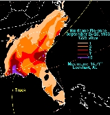
, and the heaviest rainfall was 14.71 in (373.6 mm) in Lockhart, Alabama
. The combination of winds and heavy rainfall left crop damage in the Florida panhandle and southeastern Alabama, although coastal damage was not severe. Overall, 421 houses were damaged and another three were destroyed, with monetary damage estimated around $200,000 (1953 USD
, $ USD). After landfall, Florence quickly transitioned into an extratropical cyclone, and as it continued across the southeastern United States it produced moderately heavy rainfall. It dissipated on September 28 southeast of New England
.
(29.12 inHg
). As the ship crossed through the center, it reported winds of 80 mph (130 km/h), indicating Gail attained hurricane status. There were no further observations, and the hurricane was estimated to have turned to the southwest; it weakened, dissipating on October 5 about 765 mi (1230 km) east-southeast of Barbados
.
s of 45 mph (75 km/h), before becoming extratropical on October 6. Two days later, the remnants moved over Atlantic Canada with winds of 70 mph (120 km/h), producing flooding rainfall that washed out several roads. The storm caused two deaths after it wrecked a boat in Broad Cove, Nova Scotia
. Later, the cyclone passed south of Greenland before dissipating southwest of Iceland
on October 10.
. The storm never affected land.
on October 7. Given the name Hazel, the storm tracked north-northeastward, then northeastward through the Gulf of Mexico while gradually intensifying. On October 9, Hazel made landfall just north of Fort Myers, Florida
at its peak intensity of 70 mph (120 km/h). Peak wind gusts were 80 mph (128.7 km/h), with a minimum pressure of 987 mb reported in Okeechobee City
. The storm crossed the state in about six hours, during which it weakened slightly. Over the western Atlantic Ocean, Hazel re-intensified to its peak winds, although by late on October 10 it transitioned into an extratropical storm between North Carolina and Bermuda. The remnants continued northeastward, dissipating southeast of Newfoundland on October 12. On Sable Island
, the storm produced heavy winds and rain.
Due to the fairly light winds across Florida, damage from Hazel was minor, estimated around $250,000 (1953 USD
, $ USD). During its passage, the storm spawned a tornado in St. James City
that destroyed several homes, and there were indications of another tornado in Okeechobee City. The primary impact from Hazel was from its rainfall, peaking at 10.53 inches (267.5 mm) in Daytona Beach
. The rains added to previous flooding conditions across the state, causing a record flood stage along the St. Johns River
that flooded 6 mi (9.7 km) of highway. Overall flooding damage was estimated up to $10 million (1953 USD
, $ USD), but it was impossible to determine how much was due to Hazel.
, it tracked generally westward, briefly intensifying into a tropical storm on December 8. The next day it dissipated about 270 mi (435 km) north of the Lesser Antilles.
as well. Initially, all female names were used; it was not until the 1979 season
that male and female names were used in alternating order. Names that were not assigned are marked in .
All storm names were named for the first time. No names were retired.
Atlantic hurricane season
The Atlantic hurricane season is the period in a year when hurricanes usually form in the Atlantic Ocean. Tropical cyclones in the North Atlantic are called hurricanes, tropical storms, or tropical depressions. In addition, there have been several storms over the years that have not been fully...
's limits. It is one of only four seasons to have a pre-season storm and a post-season storm, the others being the 1887
1887 Atlantic hurricane season
Another May storm formed south of Jamaica on May 17, way outside of the season and moved generally northward. It crossed Cuba on the 19th as a tropical storm, and moved out to sea. Two peaked at twice, once on May 18 and May 20. Two dissipated on the 21st in the Atlantic Ocean...
, 2003
2003 Atlantic hurricane season
The 2003 Atlantic hurricane season was an active Atlantic hurricane season with tropical activity before and after the official bounds of the season – the first such occurrence in 50 years. The season produced 21 tropical cyclones, of which 16 developed into named storms; seven...
, and 2007
2007 Atlantic hurricane season
The 2007 Atlantic hurricane season was an active Atlantic hurricane season that produced 17 tropical cyclones, 15 tropical storms, six hurricanes, and two major hurricanes. It officially started on June 1 and ended on November 30, dates which conventionally delimit the...
seasons. The season was active with fourteen total storms, six of which developed into hurricanes; four of the hurricanes attained major hurricane
Tropical cyclone scales
Tropical systems are officially ranked on one of several tropical cyclone scales according to their maximum sustained winds and in what oceanic basin they are located...
status, or a Category 3 or greater on the Saffir-Simpson scale
Saffir-Simpson Hurricane Scale
The Saffir–Simpson Hurricane Scale , or the Saffir–Simpson Hurricane Wind Scale , classifies hurricanes — Western Hemisphere tropical cyclones that exceed the intensities of tropical depressions and tropical storms — into five categories distinguished by the intensities of their sustained winds...
.
The strongest hurricane of the season was Carol
Hurricane Carol (1953)
Hurricane Carol in 1953 was one of six tropical cyclones to produce hurricane-force winds in the U.S. state of Maine. The strongest storm of the 1953 Atlantic hurricane season, Carol developed on August 28 off the west coast of Africa, although the Weather Bureau did not initiate advisories...
, although by the time it struck Atlantic Canada
Atlantic Canada
Atlantic Canada is the region of Canada comprising the four provinces located on the Atlantic coast, excluding Quebec: the three Maritime provinces – New Brunswick, Prince Edward Island, and Nova Scotia – and Newfoundland and Labrador...
it was much weaker. Both hurricanes Barbara
Hurricane Barbara (1953)
Hurricane Barbara was the second named tropical cyclone of the 1953 Atlantic hurricane season. Forming from a tropical wave on August 11 in the southern Bahamas, Barbara moved northward and attained hurricane status the next day...
and Florence
Hurricane Florence (1953)
Hurricane Florence was a minimal Atlantic hurricane that struck the Florida Panhandle in September of the 1953 season. The eighth storm and fifth hurricane of the season, Florence developed in the western Caribbean from a tropical wave near Jamaica on September 23. It produced heavy rainfall...
struck the United States; the former crossed the Outer Banks
Outer Banks
The Outer Banks is a 200-mile long string of narrow barrier islands off the coast of North Carolina, beginning in the southeastern corner of Virginia Beach on the east coast of the United States....
and impacted much of the east coast, and Florence struck a sparsely populated region of the Florida Panhandle
Florida Panhandle
The Florida Panhandle, an informal, unofficial term for the northwestern part of Florida, is a strip of land roughly 200 miles long and 50 to 100 miles wide , lying between Alabama on the north and the west, Georgia also on the north, and the Gulf of Mexico to the south. Its eastern boundary is...
without causing much damage. Bermuda was threatened by three hurricanes within two weeks. In addition to the hurricanes, Tropical Storm Alice
Tropical Storm Alice (1953)
Tropical Storm Alice was the first tropical cyclone in the Atlantic Ocean to receive a female name. It was a rare off-season tropical cyclone that hit Central America, Cuba, and Florida in late May to early June 1953. Alice formed on May 25 in the western Caribbean, and executed a large loop over...
developed in late May and left several fatalities in Cuba. The final named storm of the season, Hazel, produced additional rainfall in Florida after previous flooding conditions. There were several unnamed storms, the last of which dissipated on December 9.
Tropical Storm Alice
A tropical storm developed east of NicaraguaNicaragua
Nicaragua is the largest country in the Central American American isthmus, bordered by Honduras to the north and Costa Rica to the south. The country is situated between 11 and 14 degrees north of the Equator in the Northern Hemisphere, which places it entirely within the tropics. The Pacific Ocean...
on May 25, executing a counterclockwise loop over Central America
Central America
Central America is the central geographic region of the Americas. It is the southernmost, isthmian portion of the North American continent, which connects with South America on the southeast. When considered part of the unified continental model, it is considered a subcontinent...
. After weakening over land, Alice re-intensified over the western Caribbean, moving over western Cuba on May 21 with winds of 50 mph (80 km/h). On June 1, it entered the Gulf of Mexico, and later executed another loop off the northwest coast of Cuba. Alice quickly weakened due to a cold front
Cold front
A cold front is defined as the leading edge of a cooler mass of air, replacing a warmer mass of air.-Development of cold front:The cooler and denser air wedges under the less-dense warmer air, lifting it...
, and advisories were discontinued by June 3. While near Cuba, Alice produced drought-breaking rainfall that caused flooding and several unofficial drowning deaths.
After passing near Cuba, Alice turned to the north and restrengthened to peak winds of 70 mph (112.7 km/h). It again weakened before making landfall near Panama City Beach
Panama City Beach, Florida
Panama City Beach is a city in Bay County, Florida, United States, on the Gulf of Mexico coast. The city is often referred to under the umbrella term of "Panama City", despite being a distinct municipality from the older and larger inland Panama City to the east, making Panama City and Panama City...
on June 6 as a minimal tropical storm, and Alice dissipated shortly thereafter. Alice brought heavy rainfall to Florida, peaking at 13.48 inches (342.4 mm) in Lake Placid
Lake Placid, Florida
Lake Placid is a town in Highlands County, Florida, United States. The U.S. Census Bureau estimated the town's population as 1,878 on 1 July 2007...
. Near where it made landfall, the storm dropped light rainfall, and there were no reports of damage in the state. Alice was the first North Atlantic tropical cyclone to have a female name. It was also one of 22 tropical or subtropical cyclones on record in the month of May.
Hurricane Barbara
A tropical waveTropical wave
Tropical waves, easterly waves, or tropical easterly waves, also known as African easterly waves in the Atlantic region, are a type of atmospheric trough, an elongated area of relatively low air pressure, oriented north to south, which move from east to west across the tropics causing areas of...
developed into Tropical Storm Barbara over the Bahamas on August 11. It intensified as it moved north-northwestward, becoming a hurricane by the next day, and reaching peak winds of 110 mph (175 km/h) just south of Cape Hatteras
Cape Hatteras
Cape Hatteras is a cape on the coast of North Carolina. It is the point that protrudes the farthest to the southeast along the northeast-to-southwest line of the Atlantic coast of North America...
on August 13. Barbara moved over the Outer Banks
Outer Banks
The Outer Banks is a 200-mile long string of narrow barrier islands off the coast of North Carolina, beginning in the southeastern corner of Virginia Beach on the east coast of the United States....
, passing between Morehead City and Ocracoke
Ocracoke
Ocracoke may refer to:* Ocracoke, North Carolina* Ocracoke Island Light, a lighthouse on Ocracoke island* Ocracoke Inlet, the inlet at the southern end of Ocracoke Island...
, and it turned and accelerated to the northeast. Steadily weakening and losing tropical characteristics, the hurricane transitioned into an extratropical cyclone late on August 15. It turned northward, crossing eastern Nova Scotia
Nova Scotia
Nova Scotia is one of Canada's three Maritime provinces and is the most populous province in Atlantic Canada. The name of the province is Latin for "New Scotland," but "Nova Scotia" is the recognized, English-language name of the province. The provincial capital is Halifax. Nova Scotia is the...
and dissipating over Labrador
Labrador
Labrador is the distinct, northerly region of the Canadian province of Newfoundland and Labrador. It comprises the mainland portion of the province, separated from the island of Newfoundland by the Strait of Belle Isle...
on August 16.
Before Barbara struck the Outer Banks, officials ordered evacuations for a few islands, and several thousand tourists voluntarily left the region. Wind gusts reached 90 mph (144.8 km/h) at Hatteras and Nags Head. Torrential rainfall fell across the state and extended northward into Virginia
Virginia
The Commonwealth of Virginia , is a U.S. state on the Atlantic Coast of the Southern United States. Virginia is nicknamed the "Old Dominion" and sometimes the "Mother of Presidents" after the eight U.S. presidents born there...
, peaking at 11.1 in (281.9 mm) near Onley
Onley, Virginia
Onley is a town in Accomack County, Virginia, United States. The population was 496 at the 2000 census.-Geography:Onley is located at ....
along the Eastern Shore of Virginia
Eastern Shore of Virginia
The Eastern Shore of Virginia consists of two counties on the Atlantic coast of the Commonwealth of Virginia in the United States. The region is part of the Delmarva Peninsula and is separated from the rest of Virginia by the Chesapeake Bay. Its population was 45,553 as of 2010...
. Across the region, the hurricane left flooding and downed trees, some of which survived the Great Atlantic Hurricane of 1944. Monetary damage from Barbara was estimated around $1.3 million (1953 USD
United States dollar
The United States dollar , also referred to as the American dollar, is the official currency of the United States of America. It is divided into 100 smaller units called cents or pennies....
, $ USD), mostly from the crop damage. Newspaper reports indicated there were seven deaths in the country; two additional deaths occurred offshore Atlantic Canada
Atlantic Canada
Atlantic Canada is the region of Canada comprising the four provinces located on the Atlantic coast, excluding Quebec: the three Maritime provinces – New Brunswick, Prince Edward Island, and Nova Scotia – and Newfoundland and Labrador...
when a dory sunk.
Tropical Storm Three
On August 28, a tropical storm developed near Isla de la Juventud, south of the western tip of Cuba. It moved erratically, first quickly northwestward through Cuba, followed by a turn to the east across southern Florida. While moving through the state, the storm dropped heavy rainfall, reaching 4.67 in (118.6 mm) at Fort Lauderdale Beach; similar rainfall was observed in the northern Bahamas. Although one Weather Bureau forecaster described the system as "wide and flat", the storm gradually organized over the western Atlantic Ocean. On August 31, after turning to the northwest, the storm reached peak winds of 60 mph (95 km/h), although it weakened to a tropical depression before moving ashore near Savannah, GeorgiaSavannah, Georgia
Savannah is the largest city and the county seat of Chatham County, in the U.S. state of Georgia. Established in 1733, the city of Savannah was the colonial capital of the Province of Georgia and later the first state capital of Georgia. Today Savannah is an industrial center and an important...
on September 1. It turned to the north over land, and dissipated over Kentucky
Kentucky
The Commonwealth of Kentucky is a state located in the East Central United States of America. As classified by the United States Census Bureau, Kentucky is a Southern state, more specifically in the East South Central region. Kentucky is one of four U.S. states constituted as a commonwealth...
on September 3.
Hurricane Carol
On August 28, a tropical wave developed into a tropical depression near Cape VerdeCape Verde
The Republic of Cape Verde is an island country, spanning an archipelago of 10 islands located in the central Atlantic Ocean, 570 kilometres off the coast of Western Africa...
. After moving west-southwestward, it turned to the northwest, intensifying into a tropical storm on August 31 and into a hurricane on September 2. Passing northeast of the Lesser Antilles, Carol rapidly intensified to reach peak winds of 150 mph (240 km/h) on September 3, making it the strongest hurricane of the season. It gradually weakened, bypassing Bermuda
Bermuda
Bermuda is a British overseas territory in the North Atlantic Ocean. Located off the east coast of the United States, its nearest landmass is Cape Hatteras, North Carolina, about to the west-northwest. It is about south of Halifax, Nova Scotia, Canada, and northeast of Miami, Florida...
on September 6 and producing high waves. Carol later turned to the north-northeast, brushing Cape Cod
Cape Cod
Cape Cod, often referred to locally as simply the Cape, is a cape in the easternmost portion of the state of Massachusetts, in the Northeastern United States...
and causing boating accidents across New England. Four people were killed in the region. Fishing losses totaled around $1 million (1953 USD
United States dollar
The United States dollar , also referred to as the American dollar, is the official currency of the United States of America. It is divided into 100 smaller units called cents or pennies....
, $ USD).
After bypassing New England, Carol brushed western Nova Scotia
Nova Scotia
Nova Scotia is one of Canada's three Maritime provinces and is the most populous province in Atlantic Canada. The name of the province is Latin for "New Scotland," but "Nova Scotia" is the recognized, English-language name of the province. The provincial capital is Halifax. Nova Scotia is the...
before moving ashore near Saint John, New Brunswick
Saint John, New Brunswick
City of Saint John , or commonly Saint John, is the largest city in the province of New Brunswick, and the first incorporated city in Canada. The city is situated along the north shore of the Bay of Fundy at the mouth of the Saint John River. In 2006 the city proper had a population of 74,043...
as a minimal hurricane. As it moved ashore, it produced hurricane conditions in eastern Maine, one of only six Atlantic hurricanes to do so. In Nova Scotia, several boats were wrecked or washed ashore, with one drowning death reported. High seas caused coastal flooding, while strong winds downed large areas of trees. Heavy losses to the apple crop occurred in Annapolis Valley
Annapolis Valley
The Annapolis Valley is a valley and region in the Canadian province of Nova Scotia. It is located in the western part of the Nova Scotia peninsula, formed by a trough between two parallel mountain ranges along the shore of the Bay of Fundy.-Geography:...
, totaling $1 million (1950 CAD
Canadian dollar
The Canadian dollar is the currency of Canada. As of 2007, the Canadian dollar is the 7th most traded currency in the world. It is abbreviated with the dollar sign $, or C$ to distinguish it from other dollar-denominated currencies...
, $ USD). Carol later dissipated southwest of Greenland
Greenland
Greenland is an autonomous country within the Kingdom of Denmark, located between the Arctic and Atlantic Oceans, east of the Canadian Arctic Archipelago. Though physiographically a part of the continent of North America, Greenland has been politically and culturally associated with Europe for...
on September 9.
Hurricane Dolly
The origins of Dolly were from a tropical wave that moved through the eastern Caribbean SeaCaribbean Sea
The Caribbean Sea is a sea of the Atlantic Ocean located in the tropics of the Western hemisphere. It is bounded by Mexico and Central America to the west and southwest, to the north by the Greater Antilles, and to the east by the Lesser Antilles....
, producing 10 in (254 mm) in Saint Thomas
Saint Thomas, U.S. Virgin Islands
Saint Thomas is an island in the Caribbean Sea and with the islands of Saint John, Saint Croix, and Water Island a county and constituent district of the United States Virgin Islands , an unincorporated territory of the United States. Located on the island is the territorial capital and port of...
in the U.S. Virgin Islands. The rains closed schools and government buildings around San Juan, Puerto Rico
San Juan, Puerto Rico
San Juan , officially Municipio de la Ciudad Capital San Juan Bautista , is the capital and most populous municipality in Puerto Rico, an unincorporated territory of the United States. As of the 2010 census, it had a population of 395,326 making it the 46th-largest city under the jurisdiction of...
, and flooding was reported in Guayama
Guayama, Puerto Rico
Guayama is a municipality of Puerto Rico founded on January 29, 1736 and located on the Southern Coastal Valley region, bordering the Caribbean, south of Cayey; east of Salinas; and west of Patillas and Arroyo. Guayama is spread over 9 wards and Guayama Pueblo...
, Yabucoa
Yabucoa, Puerto Rico
Yabucoa is a small town in the south eastern tip of Puerto Rico located in the southeastern region, north of Maunabo; south of San Lorenzo, Las Piedras and Humacao; and east of Patillas and about one hour from San Juan. Yabucoa is spread over 9 wards and Yabucoa Pueblo...
, and Patillas
Patillas, Puerto Rico
Patillas is a municipality of Puerto Rico located in the southeastern coast, south of San Lorenzo; west of Yabucoa and Maunabo; and east of Guayama and Arroyo. It is spread over 15 wards and Patillas Pueblo...
. On September 8, a tropical storm developed north of Puerto Rico
Puerto Rico
Puerto Rico , officially the Commonwealth of Puerto Rico , is an unincorporated territory of the United States, located in the northeastern Caribbean, east of the Dominican Republic and west of both the United States Virgin Islands and the British Virgin Islands.Puerto Rico comprises an...
, which moved slowly west-southwestward before turning to the north. It quickly intensified, and after Hurricane Hunters
Hurricane Hunters
The Hurricane Hunters are aircraft that fly into tropical cyclones in the North Atlantic Ocean and Northeastern Pacific Ocean for the specific purpose of directly measuring weather data in and around those storms. In the United States, the Air Force, Navy, and NOAA units have all participated in...
reported an eye
Eye (cyclone)
The eye is a region of mostly calm weather found at the center of strong tropical cyclones. The eye of a storm is a roughly circular area and typically 30–65 km in diameter. It is surrounded by the eyewall, a ring of towering thunderstorms where the second most severe weather of a cyclone...
, Dolly reached hurricane status on September 9. At that time, hurricane warnings
Tropical cyclone warnings and watches
Warnings and watches are two levels of alert issued by national weather forecasting bodies to coastal areas threatened by the imminent approach of a tropical cyclone of tropical storm or hurricane intensity. They are notices to the local population and civil authorities to make appropriate...
were issued in the Bahamas, although the storm turned away from the archipelago
Archipelago
An archipelago , sometimes called an island group, is a chain or cluster of islands. The word archipelago is derived from the Greek ἄρχι- – arkhi- and πέλαγος – pélagos through the Italian arcipelago...
. It rapidly intensified to peak winds of 115 mph (185.1 km/h) on September 10, as reported by aircraft.
Dolly weakened as it accelerated northeastward, although it still threatened to strike Bermuda with strong winds. As a result, the United States Air Force
United States Air Force
The United States Air Force is the aerial warfare service branch of the United States Armed Forces and one of the American uniformed services. Initially part of the United States Army, the USAF was formed as a separate branch of the military on September 18, 1947 under the National Security Act of...
ordered all of the planes on the island to fly to the mainland. After continued weakening, Dolly passed over the island on September 11, producing only gale
Gale
A gale is a very strong wind. There are conflicting definitions of how strong a wind must be to be considered a gale. The U.S. government's National Weather Service defines a gale as 34–47 knots of sustained surface winds. Forecasters typically issue gale warnings when winds of this strength are...
-force winds, rains, and little to no damage. It deteriorated into a tropical storm on September 12 and transitioned into an extratropical cyclone later that day. The remnants of Dolly later turned eastward, dissipating just west of Portugal
Portugal
Portugal , officially the Portuguese Republic is a country situated in southwestern Europe on the Iberian Peninsula. Portugal is the westernmost country of Europe, and is bordered by the Atlantic Ocean to the West and South and by Spain to the North and East. The Atlantic archipelagos of the...
on September 17.
Hurricane Edna
Shortly behind Dolly, another tropical wave spawned a tropical depression over the Lesser AntillesLesser Antilles
The Lesser Antilles are a long, partly volcanic island arc in the Western Hemisphere. Most of its islands form the eastern boundary of the Caribbean Sea with the Atlantic Ocean, with the remainder located in the southern Caribbean just north of South America...
on September 14. As it moved through the region, it produced unsettled conditions across the northeast Caribbean. Dolly quickly intensified as it tracked northwestward, attaining hurricane status on September 15 and peak winds of 125 mph (205 km/h) the next day. After peaking, the hurricane turned to the northeast and maintained most of its intensity for a few days. It passed just north of Bermuda early on September 18 with winds of 115 mph (185 km/h), before beginning a steady weakening trend as it accelerated. By September 19, Edna completed the transition into an extratropical cyclone, lasting another day before dissipating west of Ireland
Ireland
Ireland is an island to the northwest of continental Europe. It is the third-largest island in Europe and the twentieth-largest island on Earth...
.
Before Edna struck Bermuda, the islanders were well-prepared due to being previously impacted by hurricanes Carol and Dolly, and they boarded up their homes. The hurricane caused "considerable damage", with wind gusts reaching 120 mph (193.1 km/h). The winds downed trees, blocking roads, and also caused disruptions to the power and water services. During its passage, Edna produced heavy rainfall and also damaged several roofs. There were three injuries on the island.
Tropical Storm Seven
A tropical depression formed in the western Gulf of MexicoGulf of Mexico
The Gulf of Mexico is a partially landlocked ocean basin largely surrounded by the North American continent and the island of Cuba. It is bounded on the northeast, north and northwest by the Gulf Coast of the United States, on the southwest and south by Mexico, and on the southeast by Cuba. In...
on September 14 and moved eastward. The storm produced heavy seas across the region, which damaged two small boats. After turning to the northeast, the storm reached peak winds of 70 mph (112.7 km/h), followed by executing a clockwise loop from September 16 through September 18. After maintaining peak winds for about five days, the storm weakened, by which time it curved to the northeast. On September 20, it moved ashore in Taylor County, Florida
Taylor County, Florida
Taylor County is a county located in the state of Florida. As of 2000, the population was 19,256. The U.S. Census Bureau 2005 estimate for the county was 19,622 . Its county seat is Perry, Florida.- History :Taylor County was created in 1856...
and later crossed the state. The storm dissipated on September 21 just off the Georgia coast.
Hurricane Florence
Florence developed on September 28 near JamaicaJamaica
Jamaica is an island nation of the Greater Antilles, in length, up to in width and 10,990 square kilometres in area. It is situated in the Caribbean Sea, about south of Cuba, and west of Hispaniola, the island harbouring the nation-states Haiti and the Dominican Republic...
from a tropical wave. While passing that island, it produced heavy rainfall that blocked roads. It intensified to hurricane status on September 24 while passing through the Yucatán Channel
Yucatán Channel
The Yucatán Channel is a strait between Mexico and Cuba. It connects the Yucatán Basin of the Caribbean Sea with the Gulf of Mexico. The strait is across between Cape Catoche in Mexico and Cape San Antonio, Cuba and reaches a maximum depth of .-References:...
, and while doing so left heavy damage in western Cuba. After turning north and entering the Gulf of Mexico
Gulf of Mexico
The Gulf of Mexico is a partially landlocked ocean basin largely surrounded by the North American continent and the island of Cuba. It is bounded on the northeast, north and northwest by the Gulf Coast of the United States, on the southwest and south by Mexico, and on the southeast by Cuba. In...
, Florence quickly intensified to peak winds of 125 mph (205 km/h). It gradually weakened before making landfall on September 26 as a minimal hurricane in a sparsely populated region of the Florida Panhandle
Florida Panhandle
The Florida Panhandle, an informal, unofficial term for the northwestern part of Florida, is a strip of land roughly 200 miles long and 50 to 100 miles wide , lying between Alabama on the north and the west, Georgia also on the north, and the Gulf of Mexico to the south. Its eastern boundary is...
.
Before hitting the United States Gulf Coast, about 10,000 people evacuated Panama City, Florida
Panama City, Florida
-Personal income:The median income for a household in the city was $31,572, and the median income for a family was $40,890. Males had a median income of $30,401 versus $21,431 for females. The per capita income for the city was $17,830...
, and the Weather Bureau issued timely warnings that was credited in preventing any deaths or major injuries. Winds reached 84 mph (135.2 km/h) at Eglin Air Force Base
Eglin Air Force Base
Eglin Air Force Base is a United States Air Force base located approximately 3 miles southwest of Valparaiso, Florida in Okaloosa County....
, and the heaviest rainfall was 14.71 in (373.6 mm) in Lockhart, Alabama
Lockhart, Alabama
Lockhart is a town in Covington County, Alabama, United States. At the 2000 census the population was 548.-Geography:Lockhart is located at . According to the U.S...
. The combination of winds and heavy rainfall left crop damage in the Florida panhandle and southeastern Alabama, although coastal damage was not severe. Overall, 421 houses were damaged and another three were destroyed, with monetary damage estimated around $200,000 (1953 USD
United States dollar
The United States dollar , also referred to as the American dollar, is the official currency of the United States of America. It is divided into 100 smaller units called cents or pennies....
, $ USD). After landfall, Florence quickly transitioned into an extratropical cyclone, and as it continued across the southeastern United States it produced moderately heavy rainfall. It dissipated on September 28 southeast of New England
New England
New England is a region in the northeastern corner of the United States consisting of the six states of Maine, New Hampshire, Vermont, Massachusetts, Rhode Island, and Connecticut...
.
Hurricane Gail
On October 2, a tropical wave spawned a tropical depression about 815 mi (1310 km) west-southwest of the Cape Verde islands. The depression quickly intensified into Tropical Storm Gail, and the next day, a ship encountered the storm, reporting a minimum pressure of 986 mbarBar (unit)
The bar is a unit of pressure equal to 100 kilopascals, and roughly equal to the atmospheric pressure on Earth at sea level. Other units derived from the bar are the megabar , kilobar , decibar , centibar , and millibar...
(29.12 inHg
Inch of mercury
Inches of mercury, ' is a unit of measurement for pressure. It is still widely used for barometric pressure in weather reports, refrigeration and aviation in the United States, but is seldom used elsewhere....
). As the ship crossed through the center, it reported winds of 80 mph (130 km/h), indicating Gail attained hurricane status. There were no further observations, and the hurricane was estimated to have turned to the southwest; it weakened, dissipating on October 5 about 765 mi (1230 km) east-southeast of Barbados
Barbados
Barbados is an island country in the Lesser Antilles. It is in length and as much as in width, amounting to . It is situated in the western area of the North Atlantic and 100 kilometres east of the Windward Islands and the Caribbean Sea; therein, it is about east of the islands of Saint...
.
Tropical Storm Ten
On October 3, a tropical storm developed near the southern coast of Cuba. It moved northwestward, crossing the island before turning to the northeast. Early on October 5, the storm brushed southeastern Florida, producing gusty winds and rainfall. The threat of the storm prompted small craft warnings from the Florida Keys through South Carolina. As it accelerated northeastward, the storm strengthened slightly to maximum sustained windMaximum sustained wind
The maximum sustained winds associated with a tropical cyclone are a common indicator of the intensity of the storm. Within a mature tropical cyclone, they are found within the eyewall at a distance defined as the radius of maximum wind, or RMW. Unlike gusts, the value of these winds are...
s of 45 mph (75 km/h), before becoming extratropical on October 6. Two days later, the remnants moved over Atlantic Canada with winds of 70 mph (120 km/h), producing flooding rainfall that washed out several roads. The storm caused two deaths after it wrecked a boat in Broad Cove, Nova Scotia
Broad Cove, Nova Scotia
Broad Cove is a community in the Canadian province of Nova Scotia, located in the Lunenburg Municipal District in Lunenburg County.-References:*...
. Later, the cyclone passed south of Greenland before dissipating southwest of Iceland
Iceland
Iceland , described as the Republic of Iceland, is a Nordic and European island country in the North Atlantic Ocean, on the Mid-Atlantic Ridge. Iceland also refers to the main island of the country, which contains almost all the population and almost all the land area. The country has a population...
on October 10.
Tropical Storm Eleven
On October 5, a tropical storm developed about halfway between Cape Verde and the northern Lesser Antilles. It developed in the same region as Hurricane Gail dissipated. The storm moved generally west-northwestward, reaching peak winds of 70 mph (120 km/h) about 12 hours after it was first observed. Subsequently it began a slow weakening trend, and the system dissipated on October 9 about 470 mi (755 km) north-northeast of BarbudaBarbuda
Barbuda is an island in the Eastern Caribbean, and forms part of the state of Antigua and Barbuda. It has a population of about 1,500, most of whom live in the town of Codrington.-Location:...
. The storm never affected land.
Tropical Storm Hazel
The twelfth tropical storm and the final named storm of the season formed in the Yucatán ChannelYucatán Channel
The Yucatán Channel is a strait between Mexico and Cuba. It connects the Yucatán Basin of the Caribbean Sea with the Gulf of Mexico. The strait is across between Cape Catoche in Mexico and Cape San Antonio, Cuba and reaches a maximum depth of .-References:...
on October 7. Given the name Hazel, the storm tracked north-northeastward, then northeastward through the Gulf of Mexico while gradually intensifying. On October 9, Hazel made landfall just north of Fort Myers, Florida
Fort Myers, Florida
Fort Myers is the county seat and commercial center of Lee County, Florida, United States. Its population was 62,298 in the 2010 census, a 29.23 percent increase over the 2000 figure....
at its peak intensity of 70 mph (120 km/h). Peak wind gusts were 80 mph (128.7 km/h), with a minimum pressure of 987 mb reported in Okeechobee City
Okeechobee, Florida
Okeechobee is a city in Okeechobee County, Florida, United States. The population was 5,376 at the 2000 census. As of 2004, the population recorded by the U.S. Census Bureau is 5,784. It is the county seat of Okeechobee County. The Speckled Perch Festival is held annually in honor of the most...
. The storm crossed the state in about six hours, during which it weakened slightly. Over the western Atlantic Ocean, Hazel re-intensified to its peak winds, although by late on October 10 it transitioned into an extratropical storm between North Carolina and Bermuda. The remnants continued northeastward, dissipating southeast of Newfoundland on October 12. On Sable Island
Sable Island
Sable Island is a small Canadian island situated 300 km southeast of mainland Nova Scotia in the Atlantic Ocean. The island is a year-round home to approximately five people...
, the storm produced heavy winds and rain.
Due to the fairly light winds across Florida, damage from Hazel was minor, estimated around $250,000 (1953 USD
United States dollar
The United States dollar , also referred to as the American dollar, is the official currency of the United States of America. It is divided into 100 smaller units called cents or pennies....
, $ USD). During its passage, the storm spawned a tornado in St. James City
St. James City, Florida
St. James City is a census-designated place in Lee County, Florida, United States. The population was 4,105 at the 2000 census. It is part of the Cape Coral–Fort Myers Metropolitan Statistical Area.-Geography:St...
that destroyed several homes, and there were indications of another tornado in Okeechobee City. The primary impact from Hazel was from its rainfall, peaking at 10.53 inches (267.5 mm) in Daytona Beach
Daytona Beach, Florida
Daytona Beach is a city in Volusia County, Florida, USA. According to 2008 U.S. Census Bureau estimates, the city has a population of 64,211. Daytona Beach is a principal city of the Deltona – Daytona Beach – Ormond Beach, Florida Metropolitan Statistical Area, which the census bureau estimated had...
. The rains added to previous flooding conditions across the state, causing a record flood stage along the St. Johns River
St. Johns River
The St. Johns River is the longest river in the U.S. state of Florida and its most significant for commercial and recreational use. At long, it winds through or borders twelve counties, three of which are the state's largest. The drop in elevation from the headwaters to the mouth is less than ;...
that flooded 6 mi (9.7 km) of highway. Overall flooding damage was estimated up to $10 million (1953 USD
United States dollar
The United States dollar , also referred to as the American dollar, is the official currency of the United States of America. It is divided into 100 smaller units called cents or pennies....
, $ USD), but it was impossible to determine how much was due to Hazel.
Tropical Storm Thirteen
A tropical storm developed on November 23 about 460 mi (740 km) northeast of Barbuda in the Lesser Antilles. It moved northeastward, strengthening to peak winds of 50 mph (85 km/h) on November 24. It later turned sharply to the west as it began a weakening trend, followed by a curve to the north. The cyclone dissipated on November 26 about 450 mi (725 km) east-northeast of Bermuda, without ever affecting land.Tropical Storm Fourteen
The final tropical cyclone of the season developed on December 7 about 705 mi (1735 km) east-northeast of the Lesser Antilles as a tropical depression. The first December storm since 19251925 Florida hurricane
The 1925 Florida tropical storm was the fourth and final storm of the 1925 Atlantic hurricane season, and at one time was considered the latest landfalling hurricane in the United States. Forming out of a tropical depression on November 27 near the Yucatán Peninsula, the system initially...
, it tracked generally westward, briefly intensifying into a tropical storm on December 8. The next day it dissipated about 270 mi (435 km) north of the Lesser Antilles.
Storm names
These names were used to name storms during the 1953 season. The list was the same for the 1954 season1954 Atlantic hurricane season
The 1954 Atlantic hurricane season caused over $750 million in damage, the most of any season at the time. The season officially began on June 15, and nine days later the first named storm developed. Hurricane Alice developed in the Gulf of Mexico and moved inland along the Rio Grande,...
as well. Initially, all female names were used; it was not until the 1979 season
1979 Atlantic hurricane season
The 1979 Atlantic hurricane season was the first in which the Atlantic hurricane naming list included both male and female names. It officially began on June 1 and lasted until November 30, and there was tropical cyclone activity in every month. The dates conventionally delimit the period of each...
that male and female names were used in alternating order. Names that were not assigned are marked in .
All storm names were named for the first time. No names were retired.
|
See also
- List of Atlantic hurricanes
- List of Atlantic hurricane seasons
- List of off-season Atlantic hurricanes