
1925 Florida hurricane
Encyclopedia
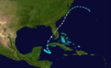
The 1925 Florida tropical storm was the fourth and final storm of the 1925 Atlantic hurricane season
, and at one time was considered the latest landfalling
hurricane in the United States
. Forming out of a tropical depression on November 27 near the Yucatán Peninsula
, the system initially tracked southeastward before turning north as it gradually intensified. After skirting western Cuba
on November 30, the storm reached peak winds of 65 mph (104.6 km/h) before striking central Florida
on December 1. Within hours, the system transitioned into an extratropical cyclone
and emerged into the Atlantic Ocean
. The system moved onshore once more on December 2 in North Carolina
before turning east, away from the United States. On December 5, the system is presumed to have dissipated offshore.
Throughout the system's existence, it was responsible for 73 fatalities, most of which resulted from offshore incidents. The worst loss of life took place off East Coast, where the 30 crewmen of the American SS Catopazi drowned. Property damage amounted to $3 million, $1 million of which was in Jacksonville
.
, nearly a month after the official end of the hurricane season. Situated over 80 °F (26.7 °C) waters, the system slowly intensified, attaining tropical storm status roughly 12 hours after forming, as it drifted towards the southeast before abruptly turning north-northwestward. Throughout November 30, the storm quickly strengthened as it brushed the western tip of Cuba
with winds of 50 mph (85 km/h). Once in the Gulf of Mexico
, the storm turned northeastward and intensified to peak winds of 65 mph (104.6 km/h). The lowest known barometric pressure attained by the storm was 995 mbar
(hPa
; 29.38 inHg) as it moved inland. Within hours of reaching this strength, the storm made landfall
just south of Fort Myers, Florida
early on December 1 as it began to transition into an extratropical cyclone
. The storm was originally thought to have moved ashore as a minimal hurricane, thus becoming the latest-landfalling hurricane in United States
history. However, a reanalysis in 2011 lowered the peak winds. While crossing the Florida peninsula, the storm briefly weakened as it completed its transition; however, once back over water, it re-intensified.
Off the coast of The Carolinas
, the former tropical storm became a large and powerful extratropical cyclone, attaining peak winds of 90 mph (140 km/h) along with a pressure of 979 mbar (hPa; 28.91 inHg), measured by the USS Patoka. Gale force winds extended to at least New Jersey
, where winds of 70 mph (110 km/h) were recorded. Throughout December 2, the storm gradually slowed as it tracked roughly parallel to the East Coast. Later that day, the system moved onshore again, this time between Wilmington
and Cape Hatteras
, with winds equivalent to a minimal hurricane. A strong area of high pressure
located over the Canadian Maritimes caused the system to turn towards the east-southeast. Over the following few days, the storm gradually weakened as it moved away from North Carolina. By December 5, the storm was no longer identifiable and is presumed to have dissipated offshore. However, a monthly weather review published in 1925 that documented the system indicated that the cyclone continued towards the west, eventually impacting Bermuda
and the Azores
. Later analysis in 2009 concluded that a separate extratropical low, which formed near the remnants of the storm, was responsible for inclement weather in both areas.
and only 0.22 in (5.58 mm) of rain fell in the city. The Swan Islands
, off the northern coast of Honduras
, recorded 2.36 in (59.94 mm) of precipitation during a three day span.
at 14.08 in (357.6 mm). The storm caused significant property and crop damage along the Gulf Coast of Florida. Trees, power lines, and telegraph wires were knocked down by high winds along the Suwannee River
. Communication throughout southern Florida was severed as miles of telegraph wires were downed during the evening of November 30. Structures previously considered safe from storms due to their location over 100 ft (30.4 m) inland sustained significant damage, probably from storm surge
. Beaches along the Atlantic coast also sustained considerable damages from the storm. Four people were killed near Tampa in two separate incidents . The first occurred when a house collapsed on three men, pinning them to the ground. The second incident occurred after a woman ran outside her home and was struck by a tree limb. At least 12 workmen were killed and 38 others injured after the bunkhouse they were sleeping in collapsed due to high winds. The facility in which they were working in also sustained $200,000 in damage from a fire ignited by the cyclone. Throughout Florida, property loses were estimated at $3 million, with $1 million in Jacksonville
alone. Damages to the citrus industry were also significant, with total losses exceeding $600,000. Losses in Miami amounted to $250,000 as up to 2 ft (0.6096 m) inundated the city for more than two days.
Shipping incidents resulting from the storm caused several deaths. A schooner carrying seven people sunk, killing all its occupants. A tug boat sank off the coast of Mobile, Alabama
while towing a lumber barge; the fate of the crew is unknown. A ship named the American SS Catopazi sank between Charleston, South Carolina
and the northern coast of Cuba
, with all 30 crew members lost. Near Daytona Beach, a vessel carrying 2,000 cases of liquor sank along with all six crewmen. The last incident, involving a yacht, occurred off the coast of Georgia. The ship sank near Savannah, Georgia
with the 12 crew members drowning. The total loss of life at sea was at least 55. Shipping throughout the East Coast was crippled by the storm as vessels were forced to seek shelter at port.
Due to the large size of the storm as an extratropical cyclone, gale and storm warnings in force from Beaufort, North Carolina
to Eastport, Maine
. In North Carolina, heavy rains and strong winds were reported along the coast. Near record high water rises were recorded around Wilmington. Cape Hatteras
was temporarily isolated from the surrounding areas as the high winds from the storm knocked down power lines throughout the area. Several buildings along the coast and numerous boats sustained considerable damage. As far north as New Jersey, gale-force winds produced by the powerful extratropical storm caused significant damage and killed at least two people. Large swells and high winds throughout New Jersey, southern New York and Connecticut resulted in significant damage. Along the coast of Long Island, large waves resulted in severe beach erosion which threatened to undermine homes. Parts of Coney Island
were inundated by the increased surf, damaging homes and businesses. Several barges in nearby marinas were torn from their moorings and swept out to sea. In Sandy Hook
, several workmen were nearly killed after a building collapsed amidst high winds. Minor precipitation was recorded throughout Rhode Island
, peaking at 0.62 in (15.7 mm).
1925 Atlantic hurricane season
The 1925 Atlantic hurricane season was an inactive Atlantic hurricane season during which four tropical cyclones, two of which were hurricanes, formed. The first storm developed on August 18, and the last dissipated on December 1. The season began at a late date, more than two months...
, and at one time was considered the latest landfalling
Landfall (meteorology)
Landfall is the event of a tropical cyclone or a waterspout coming onto land after being over water. When a waterspout makes landfall it is reclassified as a tornado, which can then cause damage inland...
hurricane in the United States
United States
The United States of America is a federal constitutional republic comprising fifty states and a federal district...
. Forming out of a tropical depression on November 27 near the Yucatán Peninsula
Yucatán Peninsula
The Yucatán Peninsula, in southeastern Mexico, separates the Caribbean Sea from the Gulf of Mexico, with the northern coastline on the Yucatán Channel...
, the system initially tracked southeastward before turning north as it gradually intensified. After skirting western Cuba
Cuba
The Republic of Cuba is an island nation in the Caribbean. The nation of Cuba consists of the main island of Cuba, the Isla de la Juventud, and several archipelagos. Havana is the largest city in Cuba and the country's capital. Santiago de Cuba is the second largest city...
on November 30, the storm reached peak winds of 65 mph (104.6 km/h) before striking central Florida
Florida
Florida is a state in the southeastern United States, located on the nation's Atlantic and Gulf coasts. It is bordered to the west by the Gulf of Mexico, to the north by Alabama and Georgia and to the east by the Atlantic Ocean. With a population of 18,801,310 as measured by the 2010 census, it...
on December 1. Within hours, the system transitioned into an extratropical cyclone
Extratropical cyclone
Extratropical cyclones, sometimes called mid-latitude cyclones or wave cyclones, are a group of cyclones defined as synoptic scale low pressure weather systems that occur in the middle latitudes of the Earth having neither tropical nor polar characteristics, and are connected with fronts and...
and emerged into the Atlantic Ocean
Atlantic Ocean
The Atlantic Ocean is the second-largest of the world's oceanic divisions. With a total area of about , it covers approximately 20% of the Earth's surface and about 26% of its water surface area...
. The system moved onshore once more on December 2 in North Carolina
North Carolina
North Carolina is a state located in the southeastern United States. The state borders South Carolina and Georgia to the south, Tennessee to the west and Virginia to the north. North Carolina contains 100 counties. Its capital is Raleigh, and its largest city is Charlotte...
before turning east, away from the United States. On December 5, the system is presumed to have dissipated offshore.
Throughout the system's existence, it was responsible for 73 fatalities, most of which resulted from offshore incidents. The worst loss of life took place off East Coast, where the 30 crewmen of the American SS Catopazi drowned. Property damage amounted to $3 million, $1 million of which was in Jacksonville
Jacksonville, Florida
Jacksonville is the largest city in the U.S. state of Florida in terms of both population and land area, and the largest city by area in the contiguous United States. It is the county seat of Duval County, with which the city government consolidated in 1968...
.
Meteorological history
The 1925 Florida tropical storm was first identified on November 27, 1925 as a tropical depression situated to the southeast of the Yucatán PeninsulaYucatán Peninsula
The Yucatán Peninsula, in southeastern Mexico, separates the Caribbean Sea from the Gulf of Mexico, with the northern coastline on the Yucatán Channel...
, nearly a month after the official end of the hurricane season. Situated over 80 °F (26.7 °C) waters, the system slowly intensified, attaining tropical storm status roughly 12 hours after forming, as it drifted towards the southeast before abruptly turning north-northwestward. Throughout November 30, the storm quickly strengthened as it brushed the western tip of Cuba
Cuba
The Republic of Cuba is an island nation in the Caribbean. The nation of Cuba consists of the main island of Cuba, the Isla de la Juventud, and several archipelagos. Havana is the largest city in Cuba and the country's capital. Santiago de Cuba is the second largest city...
with winds of 50 mph (85 km/h). Once in the Gulf of Mexico
Gulf of Mexico
The Gulf of Mexico is a partially landlocked ocean basin largely surrounded by the North American continent and the island of Cuba. It is bounded on the northeast, north and northwest by the Gulf Coast of the United States, on the southwest and south by Mexico, and on the southeast by Cuba. In...
, the storm turned northeastward and intensified to peak winds of 65 mph (104.6 km/h). The lowest known barometric pressure attained by the storm was 995 mbar
Bar (unit)
The bar is a unit of pressure equal to 100 kilopascals, and roughly equal to the atmospheric pressure on Earth at sea level. Other units derived from the bar are the megabar , kilobar , decibar , centibar , and millibar...
(hPa
Pascal (unit)
The pascal is the SI derived unit of pressure, internal pressure, stress, Young's modulus and tensile strength, named after the French mathematician, physicist, inventor, writer, and philosopher Blaise Pascal. It is a measure of force per unit area, defined as one newton per square metre...
; 29.38 inHg) as it moved inland. Within hours of reaching this strength, the storm made landfall
Landfall (meteorology)
Landfall is the event of a tropical cyclone or a waterspout coming onto land after being over water. When a waterspout makes landfall it is reclassified as a tornado, which can then cause damage inland...
just south of Fort Myers, Florida
Fort Myers, Florida
Fort Myers is the county seat and commercial center of Lee County, Florida, United States. Its population was 62,298 in the 2010 census, a 29.23 percent increase over the 2000 figure....
early on December 1 as it began to transition into an extratropical cyclone
Extratropical cyclone
Extratropical cyclones, sometimes called mid-latitude cyclones or wave cyclones, are a group of cyclones defined as synoptic scale low pressure weather systems that occur in the middle latitudes of the Earth having neither tropical nor polar characteristics, and are connected with fronts and...
. The storm was originally thought to have moved ashore as a minimal hurricane, thus becoming the latest-landfalling hurricane in United States
United States
The United States of America is a federal constitutional republic comprising fifty states and a federal district...
history. However, a reanalysis in 2011 lowered the peak winds. While crossing the Florida peninsula, the storm briefly weakened as it completed its transition; however, once back over water, it re-intensified.
Off the coast of The Carolinas
The Carolinas
The Carolinas is a term used in the United States to refer collectively to the states of North and South Carolina. Together, the two states + have a population of 13,942,126. "Carolina" would be the fifth most populous state behind California, Texas, New York, and Florida...
, the former tropical storm became a large and powerful extratropical cyclone, attaining peak winds of 90 mph (140 km/h) along with a pressure of 979 mbar (hPa; 28.91 inHg), measured by the USS Patoka. Gale force winds extended to at least New Jersey
New Jersey
New Jersey is a state in the Northeastern and Middle Atlantic regions of the United States. , its population was 8,791,894. It is bordered on the north and east by the state of New York, on the southeast and south by the Atlantic Ocean, on the west by Pennsylvania and on the southwest by Delaware...
, where winds of 70 mph (110 km/h) were recorded. Throughout December 2, the storm gradually slowed as it tracked roughly parallel to the East Coast. Later that day, the system moved onshore again, this time between Wilmington
Wilmington, North Carolina
Wilmington is a port city in and is the county seat of New Hanover County, North Carolina, United States. The population is 106,476 according to the 2010 Census, making it the eighth most populous city in the state of North Carolina...
and Cape Hatteras
Cape Hatteras
Cape Hatteras is a cape on the coast of North Carolina. It is the point that protrudes the farthest to the southeast along the northeast-to-southwest line of the Atlantic coast of North America...
, with winds equivalent to a minimal hurricane. A strong area of high pressure
High pressure area
A high-pressure area is a region where the atmospheric pressure at the surface of the planet is greater than its surrounding environment. Winds within high-pressure areas flow outward due to the higher density air near their center and friction with land...
located over the Canadian Maritimes caused the system to turn towards the east-southeast. Over the following few days, the storm gradually weakened as it moved away from North Carolina. By December 5, the storm was no longer identifiable and is presumed to have dissipated offshore. However, a monthly weather review published in 1925 that documented the system indicated that the cyclone continued towards the west, eventually impacting Bermuda
Bermuda
Bermuda is a British overseas territory in the North Atlantic Ocean. Located off the east coast of the United States, its nearest landmass is Cape Hatteras, North Carolina, about to the west-northwest. It is about south of Halifax, Nova Scotia, Canada, and northeast of Miami, Florida...
and the Azores
Azores
The Archipelago of the Azores is composed of nine volcanic islands situated in the middle of the North Atlantic Ocean, and is located about west from Lisbon and about east from the east coast of North America. The islands, and their economic exclusion zone, form the Autonomous Region of the...
. Later analysis in 2009 concluded that a separate extratropical low, which formed near the remnants of the storm, was responsible for inclement weather in both areas.
Impact
From November 28 to November 30, the storm brought light rains to most of eastern Cuba. Although the cyclone had tropical storm-force winds at the time, the highest recorded wind in Cuba was 12 mph (18 km/h) in HavanaHavana
Havana is the capital city, province, major port, and leading commercial centre of Cuba. The city proper has a population of 2.1 million inhabitants, and it spans a total of — making it the largest city in the Caribbean region, and the most populous...
and only 0.22 in (5.58 mm) of rain fell in the city. The Swan Islands
Swan Islands, Honduras
The Swan Islands, or Islas Santanilla, are a chain of three islands located in the northwestern Caribbean Sea, approximately ninety miles off the coastline of Honduras, with a land area of .-Detailed location and features:...
, off the northern coast of Honduras
Honduras
Honduras is a republic in Central America. It was previously known as Spanish Honduras to differentiate it from British Honduras, which became the modern-day state of Belize...
, recorded 2.36 in (59.94 mm) of precipitation during a three day span.
United States
During its passage through Florida, the storm produced torrential rain over coastal cities, peaking in MiamiMiami, Florida
Miami is a city located on the Atlantic coast in southeastern Florida and the county seat of Miami-Dade County, the most populous county in Florida and the eighth-most populous county in the United States with a population of 2,500,625...
at 14.08 in (357.6 mm). The storm caused significant property and crop damage along the Gulf Coast of Florida. Trees, power lines, and telegraph wires were knocked down by high winds along the Suwannee River
Suwannee River
The Suwannee River is a major river of southern Georgia and northern Florida in the United States. It is a wild blackwater river, about long. The Suwannee River is the site of the prehistoric Suwannee Straits which separated peninsular Florida from the panhandle.-Geography:The river rises in the...
. Communication throughout southern Florida was severed as miles of telegraph wires were downed during the evening of November 30. Structures previously considered safe from storms due to their location over 100 ft (30.4 m) inland sustained significant damage, probably from storm surge
Storm surge
A storm surge is an offshore rise of water associated with a low pressure weather system, typically tropical cyclones and strong extratropical cyclones. Storm surges are caused primarily by high winds pushing on the ocean's surface. The wind causes the water to pile up higher than the ordinary sea...
. Beaches along the Atlantic coast also sustained considerable damages from the storm. Four people were killed near Tampa in two separate incidents . The first occurred when a house collapsed on three men, pinning them to the ground. The second incident occurred after a woman ran outside her home and was struck by a tree limb. At least 12 workmen were killed and 38 others injured after the bunkhouse they were sleeping in collapsed due to high winds. The facility in which they were working in also sustained $200,000 in damage from a fire ignited by the cyclone. Throughout Florida, property loses were estimated at $3 million, with $1 million in Jacksonville
Jacksonville, Florida
Jacksonville is the largest city in the U.S. state of Florida in terms of both population and land area, and the largest city by area in the contiguous United States. It is the county seat of Duval County, with which the city government consolidated in 1968...
alone. Damages to the citrus industry were also significant, with total losses exceeding $600,000. Losses in Miami amounted to $250,000 as up to 2 ft (0.6096 m) inundated the city for more than two days.
Shipping incidents resulting from the storm caused several deaths. A schooner carrying seven people sunk, killing all its occupants. A tug boat sank off the coast of Mobile, Alabama
Mobile, Alabama
Mobile is the third most populous city in the Southern US state of Alabama and is the county seat of Mobile County. It is located on the Mobile River and the central Gulf Coast of the United States. The population within the city limits was 195,111 during the 2010 census. It is the largest...
while towing a lumber barge; the fate of the crew is unknown. A ship named the American SS Catopazi sank between Charleston, South Carolina
Charleston, South Carolina
Charleston is the second largest city in the U.S. state of South Carolina. It was made the county seat of Charleston County in 1901 when Charleston County was founded. The city's original name was Charles Towne in 1670, and it moved to its present location from a location on the west bank of the...
and the northern coast of Cuba
Cuba
The Republic of Cuba is an island nation in the Caribbean. The nation of Cuba consists of the main island of Cuba, the Isla de la Juventud, and several archipelagos. Havana is the largest city in Cuba and the country's capital. Santiago de Cuba is the second largest city...
, with all 30 crew members lost. Near Daytona Beach, a vessel carrying 2,000 cases of liquor sank along with all six crewmen. The last incident, involving a yacht, occurred off the coast of Georgia. The ship sank near Savannah, Georgia
Savannah, Georgia
Savannah is the largest city and the county seat of Chatham County, in the U.S. state of Georgia. Established in 1733, the city of Savannah was the colonial capital of the Province of Georgia and later the first state capital of Georgia. Today Savannah is an industrial center and an important...
with the 12 crew members drowning. The total loss of life at sea was at least 55. Shipping throughout the East Coast was crippled by the storm as vessels were forced to seek shelter at port.
Due to the large size of the storm as an extratropical cyclone, gale and storm warnings in force from Beaufort, North Carolina
Beaufort, North Carolina
Beaufort is a town in Carteret County, North Carolina, United States. Established in 1709, it is the third-oldest town in North Carolina.The population was 4,189 at the 2008 census and it is the county seat of Carteret County...
to Eastport, Maine
Eastport, Maine
Eastport is a small city in Washington County, Maine, United States. The population was 1,640 at the 2000 census. The principal island is Moose Island, which is connected to the mainland by causeway...
. In North Carolina, heavy rains and strong winds were reported along the coast. Near record high water rises were recorded around Wilmington. Cape Hatteras
Cape Hatteras
Cape Hatteras is a cape on the coast of North Carolina. It is the point that protrudes the farthest to the southeast along the northeast-to-southwest line of the Atlantic coast of North America...
was temporarily isolated from the surrounding areas as the high winds from the storm knocked down power lines throughout the area. Several buildings along the coast and numerous boats sustained considerable damage. As far north as New Jersey, gale-force winds produced by the powerful extratropical storm caused significant damage and killed at least two people. Large swells and high winds throughout New Jersey, southern New York and Connecticut resulted in significant damage. Along the coast of Long Island, large waves resulted in severe beach erosion which threatened to undermine homes. Parts of Coney Island
Coney Island
Coney Island is a peninsula and beach on the Atlantic Ocean in southern Brooklyn, New York, United States. The site was formerly an outer barrier island, but became partially connected to the mainland by landfill....
were inundated by the increased surf, damaging homes and businesses. Several barges in nearby marinas were torn from their moorings and swept out to sea. In Sandy Hook
Sandy Hook
Sandy Hook is a barrier spit along the Atlantic coast of New JerseySandy Hook may also refer to:-Places:United States* Sandy Hook , a village in the town of Newtown, Connecticut* Sandy Hook, Kentucky, a city in Elliott County...
, several workmen were nearly killed after a building collapsed amidst high winds. Minor precipitation was recorded throughout Rhode Island
Rhode Island
The state of Rhode Island and Providence Plantations, more commonly referred to as Rhode Island , is a state in the New England region of the United States. It is the smallest U.S. state by area...
, peaking at 0.62 in (15.7 mm).
See also
- List of Florida hurricanes
- 1925 Atlantic hurricane season1925 Atlantic hurricane seasonThe 1925 Atlantic hurricane season was an inactive Atlantic hurricane season during which four tropical cyclones, two of which were hurricanes, formed. The first storm developed on August 18, and the last dissipated on December 1. The season began at a late date, more than two months...