
.gif)
Hurricane Florence (1953)
Encyclopedia
Hurricane Florence was a minimal Atlantic hurricane that struck the Florida Panhandle
in September of the 1953 season
. The eighth storm and fifth hurricane of the season, Florence developed in the western Caribbean from a tropical wave near Jamaica
on September 23. It produced heavy rainfall on the nearby island, and later caused damage in western Cuba. The storm quickly intensified into a hurricane over the Yucatan Channel
, and as it moved north through the Gulf of Mexico, Florence's maximum sustained wind
s reached 125 mph (205 km/h). On September 26, the hurricane hit in a sparsely-populated region of western Florida, and shortly after landfall became an extratropical cyclone
.
Damage from Florence, with 421 houses damaged and another three destroyed. The winds destroyed the roofs of three evacuation shelters, resulting in one injury. The city of Apalachicola, Florida
was temporarily isolated due to the storm's impact. There were no deaths associated with Florence, and damage totaled $200,000 (1953 USD
, $ USD). After becoming extratropical, the remnants continued to the northeast, producing rainfall along its path before dissipating on September 28 southeast of New England
.
that moved through the Lesser Antilles
into the eastern Caribbean Sea
on September 21. The wave tracked generally westward, and spawned a tropical storm on September 23 about 100 mi (160 km) southeast of Jamaica
. Given the name Florence, the storm steadily intensified after developing, although a well-defined circulation was not observed until September 24. That day, Florence attained hurricane status in the Yucatán Channel
between the Yucatán Peninsula
and the western tip of Cuba
.
After turning north and entering the Gulf of Mexico
, Florence quickly intensified, with the Hurricane Hunters
estimating winds of 125 to 140 mph (205 to 225 km/h); the official peak intensity was reported as 125 mph (205 km/h), along with a pressure
of 968 mb. However, the estimate of the peak winds may have been too high, as ships in the region did not confirm them. On September 26, it began quickly weakening, due to a combination of colder water temperatures and cool air. At around 1800 UTC
that day, Florence made landfall
in a sparsely-populated area between Fort Walton
and Panama City Beach, Florida
with winds of 80 mph (128.7 km/h). Within six hours after moving ashore, the hurricane had transitioned into an extratropical cyclone
near the borders of Florida
, Alabama
, and Georgia
. The remnants of Florence turned the northeast along a cold front
, crossing Georgia before emerging near Savannah
. The storm paralleled the Carolinas just offshore, dissipating on September 28 southeast of New England
.
 While the storm was first developing, Florence dropped heavy rainfall up to 10 in (254 mm) in Jamaica, which isolated villages and blocked roads. Early in its existence, Hurricane Florence produced strong winds and waves along the west coast of Cuba, producing locally heavy damage. Prior to the hurricane making landfall on the United States Gulf Coast, the Weather Bureau issued warnings and recommended evacuations, which were credited in preventing any deaths or major injuries. In Florida and Alabama, the National Guard
were activated in the event of heavy damage being caused, although they were ultimately not required. The Air Force
flew hundreds of planes away from the region for safety. In addition, the Coast Guard
drove along the beach to warn people of the approaching hurricane. In Panama City, Florida
, about 10,000 people were evacuated. All warnings related to the hurricane were lowered by the New Orleans U.S. Weather Bureau office at 4 pm CDT on September 26. Offshore, a United States Coast Guard ship came to a standstill for 18 hours from the morning of September 25 into the early morning hours of September 26 while battling the cyclone out in the Gulf of Mexico.
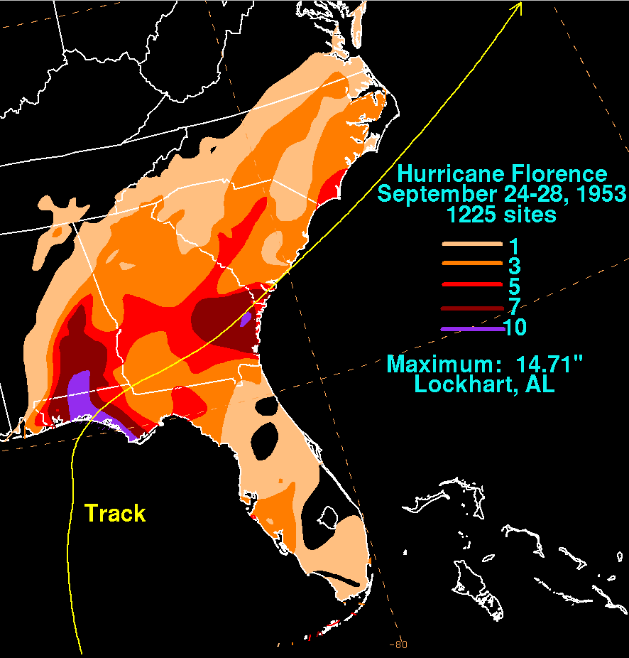
The strongest winds recorded were 84 mph (135.2 km/h) at Eglin Air Force Base
. Although Florence made landfall in Florida, the heaviest rainfall related to Florence was 14.71 in (373.6 mm) in Lockhart, Alabama
. Two intense rainbands, one on each side of the center, were responsible for the heaviest rainfall from the hurricane, including hourly rainfall rates of over 1.5 in (38.1 mm). Panama City reported 3.66 inches (93 mm) in a three hour period. The combination of winds and heavy rainfall caused minor crop damage in the Florida panhandle and southeastern Alabama. Along the coast, Florence damaged 421 houses and destroyed three others. The winds destroyed the roofs of three shelters – one at Eglin Air Force Base and two in Crestview, Florida
, forcing the evacuees to leave for safer areas; one person was injured in the process. The winds also destroyed the roofs of nine houses in Crestview. Strong waves, reaching up to 14 ft (4.3 m) in height, damaged 100 ft (30.5 m) of a fishing pier in Panama City. The waves also washed over portions of U.S. Route 98
near Apalachicola
, leaving the city isolated after power lines were downed.
Due to the strongest winds affecting a sparsely-populated area near the coast, overall damage in the United States was minor, estimated around $200,000 (1953 USD
, $ USD). Heavy rainfall was reported in portions Alabama, including a total of 8.72 in (221.5 mm), one inch shy of the 24 hour precipitation record in Montgomery
set in 1892. There, the rainfall backed up sewer drains, flooding homes and cars. The storm left about 4,000 people without electricity in the area. While Florence moved across the southeastern United States, the heaviest rainfall fell to the near and left of its center, due to interaction with a cold front.
Florida Panhandle
The Florida Panhandle, an informal, unofficial term for the northwestern part of Florida, is a strip of land roughly 200 miles long and 50 to 100 miles wide , lying between Alabama on the north and the west, Georgia also on the north, and the Gulf of Mexico to the south. Its eastern boundary is...
in September of the 1953 season
1953 Atlantic hurricane season
The 1953 Atlantic hurricane season was the first time an organized list of female names was used to name Atlantic storms. It officially began on June 15, and lasted until November 15, although activity occurred both before and after the season's limits...
. The eighth storm and fifth hurricane of the season, Florence developed in the western Caribbean from a tropical wave near Jamaica
Jamaica
Jamaica is an island nation of the Greater Antilles, in length, up to in width and 10,990 square kilometres in area. It is situated in the Caribbean Sea, about south of Cuba, and west of Hispaniola, the island harbouring the nation-states Haiti and the Dominican Republic...
on September 23. It produced heavy rainfall on the nearby island, and later caused damage in western Cuba. The storm quickly intensified into a hurricane over the Yucatan Channel
Yucatán Channel
The Yucatán Channel is a strait between Mexico and Cuba. It connects the Yucatán Basin of the Caribbean Sea with the Gulf of Mexico. The strait is across between Cape Catoche in Mexico and Cape San Antonio, Cuba and reaches a maximum depth of .-References:...
, and as it moved north through the Gulf of Mexico, Florence's maximum sustained wind
Maximum sustained wind
The maximum sustained winds associated with a tropical cyclone are a common indicator of the intensity of the storm. Within a mature tropical cyclone, they are found within the eyewall at a distance defined as the radius of maximum wind, or RMW. Unlike gusts, the value of these winds are...
s reached 125 mph (205 km/h). On September 26, the hurricane hit in a sparsely-populated region of western Florida, and shortly after landfall became an extratropical cyclone
Extratropical cyclone
Extratropical cyclones, sometimes called mid-latitude cyclones or wave cyclones, are a group of cyclones defined as synoptic scale low pressure weather systems that occur in the middle latitudes of the Earth having neither tropical nor polar characteristics, and are connected with fronts and...
.
Damage from Florence, with 421 houses damaged and another three destroyed. The winds destroyed the roofs of three evacuation shelters, resulting in one injury. The city of Apalachicola, Florida
Apalachicola, Florida
Apalachicola is a city in Franklin County, Florida, on US 98 about southwest of Tallahassee. The population was 2,334 at the 2000 census. The 2005 census estimated the city's population at 2,340...
was temporarily isolated due to the storm's impact. There were no deaths associated with Florence, and damage totaled $200,000 (1953 USD
United States dollar
The United States dollar , also referred to as the American dollar, is the official currency of the United States of America. It is divided into 100 smaller units called cents or pennies....
, $ USD). After becoming extratropical, the remnants continued to the northeast, producing rainfall along its path before dissipating on September 28 southeast of New England
New England
New England is a region in the northeastern corner of the United States consisting of the six states of Maine, New Hampshire, Vermont, Massachusetts, Rhode Island, and Connecticut...
.
Meteorological history
The origins of Hurricane Florence were from a tropical waveTropical wave
Tropical waves, easterly waves, or tropical easterly waves, also known as African easterly waves in the Atlantic region, are a type of atmospheric trough, an elongated area of relatively low air pressure, oriented north to south, which move from east to west across the tropics causing areas of...
that moved through the Lesser Antilles
Lesser Antilles
The Lesser Antilles are a long, partly volcanic island arc in the Western Hemisphere. Most of its islands form the eastern boundary of the Caribbean Sea with the Atlantic Ocean, with the remainder located in the southern Caribbean just north of South America...
into the eastern Caribbean Sea
Caribbean Sea
The Caribbean Sea is a sea of the Atlantic Ocean located in the tropics of the Western hemisphere. It is bounded by Mexico and Central America to the west and southwest, to the north by the Greater Antilles, and to the east by the Lesser Antilles....
on September 21. The wave tracked generally westward, and spawned a tropical storm on September 23 about 100 mi (160 km) southeast of Jamaica
Jamaica
Jamaica is an island nation of the Greater Antilles, in length, up to in width and 10,990 square kilometres in area. It is situated in the Caribbean Sea, about south of Cuba, and west of Hispaniola, the island harbouring the nation-states Haiti and the Dominican Republic...
. Given the name Florence, the storm steadily intensified after developing, although a well-defined circulation was not observed until September 24. That day, Florence attained hurricane status in the Yucatán Channel
Yucatán Channel
The Yucatán Channel is a strait between Mexico and Cuba. It connects the Yucatán Basin of the Caribbean Sea with the Gulf of Mexico. The strait is across between Cape Catoche in Mexico and Cape San Antonio, Cuba and reaches a maximum depth of .-References:...
between the Yucatán Peninsula
Yucatán Peninsula
The Yucatán Peninsula, in southeastern Mexico, separates the Caribbean Sea from the Gulf of Mexico, with the northern coastline on the Yucatán Channel...
and the western tip of Cuba
Cuba
The Republic of Cuba is an island nation in the Caribbean. The nation of Cuba consists of the main island of Cuba, the Isla de la Juventud, and several archipelagos. Havana is the largest city in Cuba and the country's capital. Santiago de Cuba is the second largest city...
.
After turning north and entering the Gulf of Mexico
Gulf of Mexico
The Gulf of Mexico is a partially landlocked ocean basin largely surrounded by the North American continent and the island of Cuba. It is bounded on the northeast, north and northwest by the Gulf Coast of the United States, on the southwest and south by Mexico, and on the southeast by Cuba. In...
, Florence quickly intensified, with the Hurricane Hunters
Hurricane Hunters
The Hurricane Hunters are aircraft that fly into tropical cyclones in the North Atlantic Ocean and Northeastern Pacific Ocean for the specific purpose of directly measuring weather data in and around those storms. In the United States, the Air Force, Navy, and NOAA units have all participated in...
estimating winds of 125 to 140 mph (205 to 225 km/h); the official peak intensity was reported as 125 mph (205 km/h), along with a pressure
Atmospheric pressure
Atmospheric pressure is the force per unit area exerted into a surface by the weight of air above that surface in the atmosphere of Earth . In most circumstances atmospheric pressure is closely approximated by the hydrostatic pressure caused by the weight of air above the measurement point...
of 968 mb. However, the estimate of the peak winds may have been too high, as ships in the region did not confirm them. On September 26, it began quickly weakening, due to a combination of colder water temperatures and cool air. At around 1800 UTC
Coordinated Universal Time
Coordinated Universal Time is the primary time standard by which the world regulates clocks and time. It is one of several closely related successors to Greenwich Mean Time. Computer servers, online services and other entities that rely on having a universally accepted time use UTC for that purpose...
that day, Florence made landfall
Landfall (meteorology)
Landfall is the event of a tropical cyclone or a waterspout coming onto land after being over water. When a waterspout makes landfall it is reclassified as a tornado, which can then cause damage inland...
in a sparsely-populated area between Fort Walton
Fort Walton Beach, Florida
Fort Walton Beach is a city in southern Okaloosa County, Florida, United States. As of 2005, the population estimate for Fort Walton Beach was 19,992, and as of 2010, the population estimate for Fort Walton Beach is 19,507 recorded by the U.S. Census Bureau...
and Panama City Beach, Florida
Panama City Beach, Florida
Panama City Beach is a city in Bay County, Florida, United States, on the Gulf of Mexico coast. The city is often referred to under the umbrella term of "Panama City", despite being a distinct municipality from the older and larger inland Panama City to the east, making Panama City and Panama City...
with winds of 80 mph (128.7 km/h). Within six hours after moving ashore, the hurricane had transitioned into an extratropical cyclone
Extratropical cyclone
Extratropical cyclones, sometimes called mid-latitude cyclones or wave cyclones, are a group of cyclones defined as synoptic scale low pressure weather systems that occur in the middle latitudes of the Earth having neither tropical nor polar characteristics, and are connected with fronts and...
near the borders of Florida
Florida
Florida is a state in the southeastern United States, located on the nation's Atlantic and Gulf coasts. It is bordered to the west by the Gulf of Mexico, to the north by Alabama and Georgia and to the east by the Atlantic Ocean. With a population of 18,801,310 as measured by the 2010 census, it...
, Alabama
Alabama
Alabama is a state located in the southeastern region of the United States. It is bordered by Tennessee to the north, Georgia to the east, Florida and the Gulf of Mexico to the south, and Mississippi to the west. Alabama ranks 30th in total land area and ranks second in the size of its inland...
, and Georgia
Georgia (U.S. state)
Georgia is a state located in the southeastern United States. It was established in 1732, the last of the original Thirteen Colonies. The state is named after King George II of Great Britain. Georgia was the fourth state to ratify the United States Constitution, on January 2, 1788...
. The remnants of Florence turned the northeast along a cold front
Cold front
A cold front is defined as the leading edge of a cooler mass of air, replacing a warmer mass of air.-Development of cold front:The cooler and denser air wedges under the less-dense warmer air, lifting it...
, crossing Georgia before emerging near Savannah
Savannah, Georgia
Savannah is the largest city and the county seat of Chatham County, in the U.S. state of Georgia. Established in 1733, the city of Savannah was the colonial capital of the Province of Georgia and later the first state capital of Georgia. Today Savannah is an industrial center and an important...
. The storm paralleled the Carolinas just offshore, dissipating on September 28 southeast of New England
New England
New England is a region in the northeastern corner of the United States consisting of the six states of Maine, New Hampshire, Vermont, Massachusetts, Rhode Island, and Connecticut...
.
Preparations and impact
United States National Guard
The National Guard of the United States is a reserve military force composed of state National Guard militia members or units under federally recognized active or inactive armed force service for the United States. Militia members are citizen soldiers, meaning they work part time for the National...
were activated in the event of heavy damage being caused, although they were ultimately not required. The Air Force
United States Air Force
The United States Air Force is the aerial warfare service branch of the United States Armed Forces and one of the American uniformed services. Initially part of the United States Army, the USAF was formed as a separate branch of the military on September 18, 1947 under the National Security Act of...
flew hundreds of planes away from the region for safety. In addition, the Coast Guard
United States Coast Guard
The United States Coast Guard is a branch of the United States Armed Forces and one of the seven U.S. uniformed services. The Coast Guard is a maritime, military, multi-mission service unique among the military branches for having a maritime law enforcement mission and a federal regulatory agency...
drove along the beach to warn people of the approaching hurricane. In Panama City, Florida
Panama City, Florida
-Personal income:The median income for a household in the city was $31,572, and the median income for a family was $40,890. Males had a median income of $30,401 versus $21,431 for females. The per capita income for the city was $17,830...
, about 10,000 people were evacuated. All warnings related to the hurricane were lowered by the New Orleans U.S. Weather Bureau office at 4 pm CDT on September 26. Offshore, a United States Coast Guard ship came to a standstill for 18 hours from the morning of September 25 into the early morning hours of September 26 while battling the cyclone out in the Gulf of Mexico.
The strongest winds recorded were 84 mph (135.2 km/h) at Eglin Air Force Base
Eglin Air Force Base
Eglin Air Force Base is a United States Air Force base located approximately 3 miles southwest of Valparaiso, Florida in Okaloosa County....
. Although Florence made landfall in Florida, the heaviest rainfall related to Florence was 14.71 in (373.6 mm) in Lockhart, Alabama
Lockhart, Alabama
Lockhart is a town in Covington County, Alabama, United States. At the 2000 census the population was 548.-Geography:Lockhart is located at . According to the U.S...
. Two intense rainbands, one on each side of the center, were responsible for the heaviest rainfall from the hurricane, including hourly rainfall rates of over 1.5 in (38.1 mm). Panama City reported 3.66 inches (93 mm) in a three hour period. The combination of winds and heavy rainfall caused minor crop damage in the Florida panhandle and southeastern Alabama. Along the coast, Florence damaged 421 houses and destroyed three others. The winds destroyed the roofs of three shelters – one at Eglin Air Force Base and two in Crestview, Florida
Crestview, Florida
Crestview is a city in Okaloosa County, Florida, United States. Crestview’s name was chosen because of its location on the peak of a long woodland range between the Yellow and Shoal rivers which flow almost parallel on the east and west side of the City....
, forcing the evacuees to leave for safer areas; one person was injured in the process. The winds also destroyed the roofs of nine houses in Crestview. Strong waves, reaching up to 14 ft (4.3 m) in height, damaged 100 ft (30.5 m) of a fishing pier in Panama City. The waves also washed over portions of U.S. Route 98
U.S. Route 98 in Florida
U.S. Route 98 is an east-west United States highway that runs from western Mississippi to southern Florida. It was established in 1933 as a route between Pensacola, Florida and Apalachicola, Florida, and has since been extended eastward across the Florida Peninsula and westward into Mississippi...
near Apalachicola
Apalachicola, Florida
Apalachicola is a city in Franklin County, Florida, on US 98 about southwest of Tallahassee. The population was 2,334 at the 2000 census. The 2005 census estimated the city's population at 2,340...
, leaving the city isolated after power lines were downed.
Due to the strongest winds affecting a sparsely-populated area near the coast, overall damage in the United States was minor, estimated around $200,000 (1953 USD
United States dollar
The United States dollar , also referred to as the American dollar, is the official currency of the United States of America. It is divided into 100 smaller units called cents or pennies....
, $ USD). Heavy rainfall was reported in portions Alabama, including a total of 8.72 in (221.5 mm), one inch shy of the 24 hour precipitation record in Montgomery
Montgomery, Alabama
Montgomery is the capital of the U.S. state of Alabama, and is the county seat of Montgomery County. It is located on the Alabama River southeast of the center of the state, in the Gulf Coastal Plain. As of the 2010 census, Montgomery had a population of 205,764 making it the second-largest city...
set in 1892. There, the rainfall backed up sewer drains, flooding homes and cars. The storm left about 4,000 people without electricity in the area. While Florence moved across the southeastern United States, the heaviest rainfall fell to the near and left of its center, due to interaction with a cold front.
See also
- List of Florida hurricanes (1950-1974)
- List of North Carolina hurricanes (1950-1979)
- Other storms of the same name