

Walter Muma
Encyclopedia
Walter Muma is a Canadian man who is on record for completing a 3-month 11,500-mile (18,660 km) journey across Canada and Alaska
by moped
. The journey took place during the summer of 1978, began in Toronto
, passed through Yukon
and Alaska, continued up the Dempster Highway
to Inuvik, Northwest Territories
, and finally back to Toronto.
, Canada
to Robert and Dorothy Muma. His father was a bookbinder and restorer of books; both his parents affiliated religiously as Quakers
. He has one sister, Alice, who married David Rutherford.
He attended Jesse Ketchum Public School and Northern Secondary School. Three days after graduating high school in 1974, he set out on an 800-mile bike ride to northern Ontario. He also hitchhiked his way out to British Columbia
, Yukon, Alaska and Nova Scotia
, returning to Toronto after four and a half months on the road.
Muma bought his first moped
in 1975. That year, he toured most of Ontario and parts of the United States. In summer 1977, he rode to Newfoundland
and parts of Quebec
.
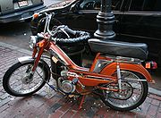 For his 3-month trip in 1978, Muma purchased a French made, orange 1978 Motobécane
Mobylette
50v, which was equipped with a 49cc, 2.5 horsepower, two-stroke engine. This model was Motobecane's top-of-the-line moped offering at the time. It was capable of about 25-30 mph top-speed on even roadway and averaged 150 miles per gallon.
Muma disassembled an older Motobecane for spare parts to bring on his trip. He also brought approximately 50 pounds of gear, including a tent, sleeping bag, clothing, tools, food and water, spare fuel cans, and oil to mix with the fuel.
and oil
deposits located there. Companies were moving in to mine
and drill, and as a result, many roads were being paved and certain areas were being cleared. As Muma stated in news articles that covered his trip, "I want to see more of the north land, because it's changing so rapidly....I want to get there before the changes."
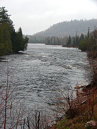
He had also developed an interest in photography previous to his trip. Throughout the three-month journey, he took a number of photographs of mountains, streams, his campgrounds, and a variety of other natural settings.
of the Trans-Canada Highway
, and continued North on the highway, curving west to Wawa
. The Chapleau Route itself is a desolate stretch, extending 215 miles from Thessalon
to Wawa. No other towns exist between these two, however the road passes along the Mississagi River
and near Aubrey Falls.
After passing Wawa, Muma continued along the main Trans-Canada Highway route, along the edge of Lake Superior
. A few miles off the highway, east of Thunder Bay
, he visited the Ouimet Canyon
, and later, near the western edge of Lake Superior, Kakabeka Falls
.
 On June 12, Muma crossed into Manitoba
, crossing the Red River
. Two days later, he crossed into Saskatchewan
, passing Regina
, and on June 18, he crossed into Alberta
. Most of the terrain, thus far, had proved to be relatively easy to traverse on the moped, as it is primarily flatland prairie
, however he did have some difficulty with a few dirt roads. Three weeks after beginning his journey, he reached the border of British Columbia
and Dawson Creek
.
. In 1979, only the first 90 miles of this highway were paved, with the remainder, until reaching the Alaska border, laid as gravel. At the time it was fairly remote- however, some years later, it was paved over in its entirety.
After heading out of Dawson Creek, Muma crossed over the Kiskatinaw River
, and then shortly thereafter the Peace River
. Near the 93 mile marker, he reached the end of the paved roadway and continued on the gravel portion, passing gas wells and the Sikanni Chief River
valley.
After 186 miles, the highway actually passes over Trutch Mountain. Minaker River passes nearby. Further travel, after 300 miles had passed, brought him to Steamboat Mountain
near the Muskwa River
, Indian Head Mountain and eventually travelled alongside the Tetsa River. By mile 384, although it was June 26, Muma encountered a large patch of snow next to the roadway left over from the previous winter. By this point, the terrain was becoming increasingly mountainous, as Muma continued through the Rocky Mountains
, passing Summit Lake
and McDonald River Gorge.
Near mile 401, Muma took a short side trip on a partially washed-out road to the abandoned Churchill Mines. Although the road was washed out, he was able to traverse it on the moped, later encountering increasingly rugged scenery and an abandoned cabin, before he finally reached one of the mines, where he camped for the night. In the morning, he photographed a nearby herd of mountain sheep.
After passing the mines, he resumed traveling the Alaska Highway, passing McDonald River and Toad River
. He camped at Muncho Lake, photographing more mountain sheep. Near mile 504, the road follows the Liard River
for some time, eventually winding up in Watson Lake
, Yukon
.
and Alaska. From Watson Lake, he headed North up the Robert Campbell Highway. A side trip included up the Nahanni Range Road and back. Continuing on the Robert Campbell Highway, he passed the Finlayson River and eventually wound up at the Pelly River
, near the town of Ross River
. He then followed the Canol Road
, to Quiet Lake, and then back to the Alaska Highway. He took a side trip to Atlin, British Columbia
(which was then only accessible from Yukon), passing the ghost town
of O'Donnell. Other wide trips included to Carcross
, Haines, Alaska
, the Taylor Highway
, to Eagle, Alaska
, eventually resuming his trip on the Alaska Highway to Dawson City
. Further side trips included to Inuvik, Northwest Territories
and back South to Whitehorse.
. He passed by Cassiar
, a company town then owned by an asbestos mining company. He traveled past the Coast Mountains
and the Ningunsaw River, reaching the Bear Glacier, which at the time reached nearly to the road itself (due to climate change, the glacier has melted and retreated considerably as of 2004). From here, he traveled to Stewart
, and then back towards Ontario.
, passing Hudson Bay Mountain and the Fraser River
. He continued through Alberta, Saskatchewan and Manitoba, eventually reaching the border of Ontario. By this point, his moped, which had been brand new when starting out, was now very dirty and completely loaded down with equipment.
His total trip took approximately three months, covered 11,500 miles and ended back in Toronto on September 7, 1978.
for two weeks and India
for six months.
and worked as an accountant in a small firm for eight years. In recent years, he has run his own computer consulting business.
Alaska
Alaska is the largest state in the United States by area. It is situated in the northwest extremity of the North American continent, with Canada to the east, the Arctic Ocean to the north, and the Pacific Ocean to the west and south, with Russia further west across the Bering Strait...
by moped
Moped
Mopeds are a type of low-powered motorcycle designed to provide economical and relatively safe transport with minimal licensing requirements.Mopeds were once all equipped with bicycle-like pedals , but moped has been increasingly applied by governments to vehicles without pedals, based on their...
. The journey took place during the summer of 1978, began in Toronto
Toronto
Toronto is the provincial capital of Ontario and the largest city in Canada. It is located in Southern Ontario on the northwestern shore of Lake Ontario. A relatively modern city, Toronto's history dates back to the late-18th century, when its land was first purchased by the British monarchy from...
, passed through Yukon
Yukon
Yukon is the westernmost and smallest of Canada's three federal territories. It was named after the Yukon River. The word Yukon means "Great River" in Gwich’in....
and Alaska, continued up the Dempster Highway
Dempster Highway
The Dempster Highway, also referred to as Yukon Highway 5 and Northwest Territories Highway 8, is a highway that connects the Klondike Highway in Yukon, Canada to Inuvik, Northwest Territories on the Mackenzie River delta...
to Inuvik, Northwest Territories
Inuvik, Northwest Territories
Inuvik is a town in the Northwest Territories of Canada and is the administrative centre for the Inuvik Region.The population as of the 2006 Census was 3,484, but the two previous census counts show wide fluctuations due to economic conditions: 2,894 in 2001 and 3,296 in 1996...
, and finally back to Toronto.
Biography
Muma was born in TorontoToronto
Toronto is the provincial capital of Ontario and the largest city in Canada. It is located in Southern Ontario on the northwestern shore of Lake Ontario. A relatively modern city, Toronto's history dates back to the late-18th century, when its land was first purchased by the British monarchy from...
, Canada
Canada
Canada is a North American country consisting of ten provinces and three territories. Located in the northern part of the continent, it extends from the Atlantic Ocean in the east to the Pacific Ocean in the west, and northward into the Arctic Ocean...
to Robert and Dorothy Muma. His father was a bookbinder and restorer of books; both his parents affiliated religiously as Quakers
Religious Society of Friends
The Religious Society of Friends, or Friends Church, is a Christian movement which stresses the doctrine of the priesthood of all believers. Members are known as Friends, or popularly as Quakers. It is made of independent organisations, which have split from one another due to doctrinal differences...
. He has one sister, Alice, who married David Rutherford.
He attended Jesse Ketchum Public School and Northern Secondary School. Three days after graduating high school in 1974, he set out on an 800-mile bike ride to northern Ontario. He also hitchhiked his way out to British Columbia
British Columbia
British Columbia is the westernmost of Canada's provinces and is known for its natural beauty, as reflected in its Latin motto, Splendor sine occasu . Its name was chosen by Queen Victoria in 1858...
, Yukon, Alaska and Nova Scotia
Nova Scotia
Nova Scotia is one of Canada's three Maritime provinces and is the most populous province in Atlantic Canada. The name of the province is Latin for "New Scotland," but "Nova Scotia" is the recognized, English-language name of the province. The provincial capital is Halifax. Nova Scotia is the...
, returning to Toronto after four and a half months on the road.
Muma bought his first moped
Moped
Mopeds are a type of low-powered motorcycle designed to provide economical and relatively safe transport with minimal licensing requirements.Mopeds were once all equipped with bicycle-like pedals , but moped has been increasingly applied by governments to vehicles without pedals, based on their...
in 1975. That year, he toured most of Ontario and parts of the United States. In summer 1977, he rode to Newfoundland
Newfoundland and Labrador
Newfoundland and Labrador is the easternmost province of Canada. Situated in the country's Atlantic region, it incorporates the island of Newfoundland and mainland Labrador with a combined area of . As of April 2011, the province's estimated population is 508,400...
and parts of Quebec
Quebec
Quebec or is a province in east-central Canada. It is the only Canadian province with a predominantly French-speaking population and the only one whose sole official language is French at the provincial level....
.
Record-breaking trip
Motobécane
Motobécane was a French manufacturer of bicycles, mopeds, motorcycles, and other small vehicles, established in 1923. "Motobécane" is a compound of "moto", slang for motorcycle; "bécane" is slang for "bike."...
Mobylette
Mobylette
The Mobylette, sometimes shortened as Moby, is a model of moped manufactured by French manufacturer Motobecane during the second half of the 20th century. The Mobylette was launched in 1949 and was manufactured until 1997 with production number exceeding over 14 million with the 1970s being its...
50v, which was equipped with a 49cc, 2.5 horsepower, two-stroke engine. This model was Motobecane's top-of-the-line moped offering at the time. It was capable of about 25-30 mph top-speed on even roadway and averaged 150 miles per gallon.
Muma disassembled an older Motobecane for spare parts to bring on his trip. He also brought approximately 50 pounds of gear, including a tent, sleeping bag, clothing, tools, food and water, spare fuel cans, and oil to mix with the fuel.
Reasons
During the 1970s, Alaska and the northern portions of Canada were changing significantly as a result of the large mineralMineral
A mineral is a naturally occurring solid chemical substance formed through biogeochemical processes, having characteristic chemical composition, highly ordered atomic structure, and specific physical properties. By comparison, a rock is an aggregate of minerals and/or mineraloids and does not...
and oil
Oil
An oil is any substance that is liquid at ambient temperatures and does not mix with water but may mix with other oils and organic solvents. This general definition includes vegetable oils, volatile essential oils, petrochemical oils, and synthetic oils....
deposits located there. Companies were moving in to mine
Mining
Mining is the extraction of valuable minerals or other geological materials from the earth, from an ore body, vein or seam. The term also includes the removal of soil. Materials recovered by mining include base metals, precious metals, iron, uranium, coal, diamonds, limestone, oil shale, rock...
and drill, and as a result, many roads were being paved and certain areas were being cleared. As Muma stated in news articles that covered his trip, "I want to see more of the north land, because it's changing so rapidly....I want to get there before the changes."
He had also developed an interest in photography previous to his trip. Throughout the three-month journey, he took a number of photographs of mountains, streams, his campgrounds, and a variety of other natural settings.
Toronto to Dawson Creek
Muma began his trip on June 3, 1978, leaving his home in Toronto. He rode to the Chapleau RouteChapleau, Ontario
Chapleau is a township in Sudbury District, Ontario, Canada. It is home to one of the world's largest wildlife preserves. Chapleau has a population of 2,354 according to the Canada 2006 Census....
of the Trans-Canada Highway
Trans-Canada Highway
The Trans-Canada Highway is a federal-provincial highway system that joins the ten provinces of Canada. It is, along with the Trans-Siberian Highway and Australia's Highway 1, one of the world's longest national highways, with the main route spanning 8,030 km...
, and continued North on the highway, curving west to Wawa
Wawa, Ontario
Wawa is a township in the Canadian province of Ontario, located within the Algoma District. Formerly known as the township of Michipicoten, the township was officially renamed for its largest and best-known community in 2009....
. The Chapleau Route itself is a desolate stretch, extending 215 miles from Thessalon
Thessalon, Ontario
Thessalon is a town in the Canadian province of Ontario, located at the junction of Highway 17 and Highway 129. It is surrounded by but not part of the municipality of Huron Shores, and is part of the District of Algoma....
to Wawa. No other towns exist between these two, however the road passes along the Mississagi River
Mississagi River
The Mississagi River is a river in Algoma and Sudbury Districts, Ontario, Canada, that originates in Sudbury District and flows to Lake Huron at Blind River, Algoma District.-Etymology:...
and near Aubrey Falls.
After passing Wawa, Muma continued along the main Trans-Canada Highway route, along the edge of Lake Superior
Lake Superior
Lake Superior is the largest of the five traditionally-demarcated Great Lakes of North America. It is bounded to the north by the Canadian province of Ontario and the U.S. state of Minnesota, and to the south by the U.S. states of Wisconsin and Michigan. It is the largest freshwater lake in the...
. A few miles off the highway, east of Thunder Bay
Thunder Bay, Ontario
Thunder Bay is a city in and the seat of Thunder Bay District, Ontario, Canada. It is the most populous municipality in Northwestern Ontario, and the second most populous in Northern Ontario after Greater Sudbury...
, he visited the Ouimet Canyon
Ouimet Canyon
Ouimet Canyon is a large gorge in the Canadian province of Ontario, about northeast of Thunder Bay in Dorion Township. The gorge is deep, wide and in length, protected in the Ouimet Canyon Provincial Park....
, and later, near the western edge of Lake Superior, Kakabeka Falls
Kakabeka Falls
Kakabeka Falls Provincial Park, established in 1955, covers 5 km² and is managed by Ontario Parks. It surrounds the falls and extends along the Kaministiquia River, which was used centuries ago by Voyageurs, who were the first Europeans to overwinter annually in northern Ontario...
.
Manitoba
Manitoba is a Canadian prairie province with an area of . The province has over 110,000 lakes and has a largely continental climate because of its flat topography. Agriculture, mostly concentrated in the fertile southern and western parts of the province, is vital to the province's economy; other...
, crossing the Red River
Red River of the North
The Red River is a North American river. Originating at the confluence of the Bois de Sioux and Otter Tail rivers in the United States, it flows northward through the Red River Valley and forms the border between the U.S. states of Minnesota and North Dakota before continuing into Manitoba, Canada...
. Two days later, he crossed into Saskatchewan
Saskatchewan
Saskatchewan is a prairie province in Canada, which has an area of . Saskatchewan is bordered on the west by Alberta, on the north by the Northwest Territories, on the east by Manitoba, and on the south by the U.S. states of Montana and North Dakota....
, passing Regina
Regina, Saskatchewan
Regina is the capital city of the Canadian province of Saskatchewan. The city is the second-largest in the province and a cultural and commercial centre for southern Saskatchewan. It is governed by Regina City Council. Regina is the cathedral city of the Roman Catholic and Romanian Orthodox...
, and on June 18, he crossed into Alberta
Alberta
Alberta is a province of Canada. It had an estimated population of 3.7 million in 2010 making it the most populous of Canada's three prairie provinces...
. Most of the terrain, thus far, had proved to be relatively easy to traverse on the moped, as it is primarily flatland prairie
Prairie
Prairies are considered part of the temperate grasslands, savannas, and shrublands biome by ecologists, based on similar temperate climates, moderate rainfall, and grasses, herbs, and shrubs, rather than trees, as the dominant vegetation type...
, however he did have some difficulty with a few dirt roads. Three weeks after beginning his journey, he reached the border of British Columbia
British Columbia
British Columbia is the westernmost of Canada's provinces and is known for its natural beauty, as reflected in its Latin motto, Splendor sine occasu . Its name was chosen by Queen Victoria in 1858...
and Dawson Creek
Dawson Creek, British Columbia
Dawson Creek is a small city in northeastern British Columbia, Canada. The municipality of had a population of 11,529 in 2009. Dawson Creek derives its name from the creek of the same name that runs through the community. The creek was named after George Mercer Dawson by a member of his land...
.
Alaska Highway
Dawson Creek marks the beginning of the Alaska HighwayAlaska Highway
The Alaska Highway was constructed during World War II for the purpose of connecting the contiguous U.S. to Alaska through Canada. It begins at the junction with several Canadian highways in Dawson Creek, British Columbia and runs to Delta Junction, Alaska, via Whitehorse, Yukon...
. In 1979, only the first 90 miles of this highway were paved, with the remainder, until reaching the Alaska border, laid as gravel. At the time it was fairly remote- however, some years later, it was paved over in its entirety.
After heading out of Dawson Creek, Muma crossed over the Kiskatinaw River
Kiskatinaw River
Kiskatinaw is a small river in north-eastern British Columbia, Canada.It is a tributary of the Peace River.Bearhole Lake Provincial Park and Protected Area is established around the headwaterd of the river, and One Island Lake Provincial Park is located on the middle course...
, and then shortly thereafter the Peace River
Peace River (Canada)
The Peace River is a river in Canada that originates in the Rocky Mountains of northern British Columbia and flows to the northeast through northern Alberta. The Peace River flows into the Slave River, a tributary of the Mackenzie River. The Mackenzie is the 12th longest river in the world,...
. Near the 93 mile marker, he reached the end of the paved roadway and continued on the gravel portion, passing gas wells and the Sikanni Chief River
Sikanni Chief River
The Sikanni Chief River is a river in the Northern Rocky Mountains region of the Northern Interior of British Columbia, Canada. It joins the Fontas River to form the Fort Nelson River southeast of the town of Fort Nelson. Its headwaters are near Mount McCusker, northeast of the head of the Finlay...
valley.
After 186 miles, the highway actually passes over Trutch Mountain. Minaker River passes nearby. Further travel, after 300 miles had passed, brought him to Steamboat Mountain
Steamboat Mountain
According to the USGS GNIS, there are 12 mountains in the United States named Steamboat Mountain:...
near the Muskwa River
Muskwa River
The Muskwa River flows 257 km through northern British Columbia, Canada. It is a major tributary of the Fort Nelson River - part of the Mackenzie River system. The river rises at Fern Lake in the Bedaux Pass in the Northern Rocky Mountains. From there, it flows generally east, then north,...
, Indian Head Mountain and eventually travelled alongside the Tetsa River. By mile 384, although it was June 26, Muma encountered a large patch of snow next to the roadway left over from the previous winter. By this point, the terrain was becoming increasingly mountainous, as Muma continued through the Rocky Mountains
Rocky Mountains
The Rocky Mountains are a major mountain range in western North America. The Rocky Mountains stretch more than from the northernmost part of British Columbia, in western Canada, to New Mexico, in the southwestern United States...
, passing Summit Lake
Summit Lake
-Lakes:In Canada:*Summit Lake , Central Interior of British Columbia.*Summit Lake , Algoma District, Ontario.*Summit Lake , Algoma District, Ontario.*Summit Lake...
and McDonald River Gorge.
Near mile 401, Muma took a short side trip on a partially washed-out road to the abandoned Churchill Mines. Although the road was washed out, he was able to traverse it on the moped, later encountering increasingly rugged scenery and an abandoned cabin, before he finally reached one of the mines, where he camped for the night. In the morning, he photographed a nearby herd of mountain sheep.
After passing the mines, he resumed traveling the Alaska Highway, passing McDonald River and Toad River
Toad River
The Toad River is a river in the Canadian province of British Columbia.The Toad River was named for the numerous large toads seen along its banks by fur traders of the early 19th century...
. He camped at Muncho Lake, photographing more mountain sheep. Near mile 504, the road follows the Liard River
Liard River
The Liard River flows through Yukon, British Columbia and the Northwest Territories, Canada. Rising in the Saint Cyr Range of the Pelly Mountains in southeastern Yukon, it flows southeast through British Columbia, marking the northern end of the Rocky Mountains and then curving northeast back...
for some time, eventually winding up in Watson Lake
Watson Lake
Watson Lake may refer to:* Watson Lake, Yukon* Watson Lake * Watson Lake * Watson Lake * Watson Lake...
, Yukon
Yukon
Yukon is the westernmost and smallest of Canada's three federal territories. It was named after the Yukon River. The word Yukon means "Great River" in Gwich’in....
.
Yukon and Alaska
Muma spent some time wandering on side roads throughout the YukonYukon
Yukon is the westernmost and smallest of Canada's three federal territories. It was named after the Yukon River. The word Yukon means "Great River" in Gwich’in....
and Alaska. From Watson Lake, he headed North up the Robert Campbell Highway. A side trip included up the Nahanni Range Road and back. Continuing on the Robert Campbell Highway, he passed the Finlayson River and eventually wound up at the Pelly River
Pelly River
The Pelly River is a river in Canada, and is a headstream of the Yukon River. The river originates west of the Mackenzie Mountains and flows 530 km long through the south central Yukon. The Pelly has two main tributaries, the Ross and Macmillan rivers.The river was named by Robert Campbell in...
, near the town of Ross River
Ross River, Yukon
Ross River is an unincorporated community in the Yukon, Canada. It lies at the juncture of the Ross River and the Pelly River, along the Canol Road, not far from the Campbell Highway. Primary access to the Campbell Highway is a nine-mile access road of superior alignment, not the six-mile Canol...
. He then followed the Canol Road
Canol Road
The Canol Road was part of a project to build a pipeline and a road from Norman Wells, Northwest Territories to Whitehorse, Yukon during World War II. The pipeline no longer exists, but the long Yukon portion of the road is maintained by the Yukon Government during summer months...
, to Quiet Lake, and then back to the Alaska Highway. He took a side trip to Atlin, British Columbia
Atlin, British Columbia
Atlin is a community in northwestern British Columbia, Canada, located on the eastern shore of Atlin Lake. In addition to continued gold-mining activity, Atlin is a tourist destination for fishing, hiking and Heliskiing. As of 2004, there are 450 permanent residents.The name comes from Áa Tlein,...
(which was then only accessible from Yukon), passing the ghost town
Ghost town
A ghost town is an abandoned town or city. A town often becomes a ghost town because the economic activity that supported it has failed, or due to natural or human-caused disasters such as floods, government actions, uncontrolled lawlessness, war, or nuclear disasters...
of O'Donnell. Other wide trips included to Carcross
Carcross, Yukon
Carcross, originally known as Caribou Crossing, is an unincorporated community in the Territory of Yukon, Canada on Bennett Lake and Nares Lake. It has a population of 431 and is home to the Carcross/Tagish First Nation....
, Haines, Alaska
Haines, Alaska
Haines is a census-designated place in Haines Borough, Alaska, United States. As of the 2000 census, the population of the area was 1,811. Haines was formerly a city but no longer has a municipal government...
, the Taylor Highway
Taylor Highway
The Taylor Highway is a highway in the U.S. state of Alaska that extends 160 miles from Tetlin, about 11 miles south of Tok on the Alaska Highway, to Eagle....
, to Eagle, Alaska
Eagle, Alaska
Eagle is a city located along the United States-Canada border in the Southeast Fairbanks Census Area, Alaska, United States. It includes Eagle Historic District, a U.S. National Historic Landmark. The population was 129 at the 2000 census...
, eventually resuming his trip on the Alaska Highway to Dawson City
Dawson City, Yukon
The Town of the City of Dawson or Dawson City is a town in the Yukon, Canada.The population was 1,327 at the 2006 census. The area draws some 60,000 visitors each year...
. Further side trips included to Inuvik, Northwest Territories
Inuvik, Northwest Territories
Inuvik is a town in the Northwest Territories of Canada and is the administrative centre for the Inuvik Region.The population as of the 2006 Census was 3,484, but the two previous census counts show wide fluctuations due to economic conditions: 2,894 in 2001 and 3,296 in 1996...
and back South to Whitehorse.
British Columbia
Muma left Whitehorse and proceeded on the Stewart-Cassiar Highway to British ColumbiaBritish Columbia
British Columbia is the westernmost of Canada's provinces and is known for its natural beauty, as reflected in its Latin motto, Splendor sine occasu . Its name was chosen by Queen Victoria in 1858...
. He passed by Cassiar
Cassiar, British Columbia
Cassiar is a ghost town in British Columbia, Canada. It was a small company-owned asbestos mining town located in the Cassiar Mountains of Northern British Columbia north of Dease Lake. After forty years of operation, starting in 1952, the mine was unexpectedly forced to close in 1992...
, a company town then owned by an asbestos mining company. He traveled past the Coast Mountains
Coast Mountains
The Coast Mountains are a major mountain range, in the Pacific Coast Ranges, of western North America, extending from southwestern Yukon through the Alaska Panhandle and virtually all of the Coast of British Columbia. They are so-named because of their proximity to the sea coast, and are often...
and the Ningunsaw River, reaching the Bear Glacier, which at the time reached nearly to the road itself (due to climate change, the glacier has melted and retreated considerably as of 2004). From here, he traveled to Stewart
Stewart, British Columbia
Stewart is a small town, incorporated as a district municipality at the head of the Portland Canal in northwestern British Columbia, Canada. In 2006, its population was about 496.-History:...
, and then back towards Ontario.
Back to Ontario
Next, Muma followed the Yellowhead HighwayYellowhead Highway
The Yellowhead Highway is a major east-west highway connecting the four western Canadian provinces of British Columbia, Alberta, Saskatchewan, and Manitoba. Although part of the Trans-Canada Highway system, the highway should not be confused with the more southerly, originally-designated...
, passing Hudson Bay Mountain and the Fraser River
Fraser River
The Fraser River is the longest river within British Columbia, Canada, rising at Fraser Pass near Mount Robson in the Rocky Mountains and flowing for , into the Strait of Georgia at the city of Vancouver. It is the tenth longest river in Canada...
. He continued through Alberta, Saskatchewan and Manitoba, eventually reaching the border of Ontario. By this point, his moped, which had been brand new when starting out, was now very dirty and completely loaded down with equipment.
His total trip took approximately three months, covered 11,500 miles and ended back in Toronto on September 7, 1978.
Later trips
Muma continued to tour, backpack, hike and canoe in Canada and the United States after his record-breaking moped trip. He also visited AustraliaAustralia
Australia , officially the Commonwealth of Australia, is a country in the Southern Hemisphere comprising the mainland of the Australian continent, the island of Tasmania, and numerous smaller islands in the Indian and Pacific Oceans. It is the world's sixth-largest country by total area...
for two weeks and India
India
India , officially the Republic of India , is a country in South Asia. It is the seventh-largest country by geographical area, the second-most populous country with over 1.2 billion people, and the most populous democracy in the world...
for six months.
Employment
Muma worked in the post office and also as a driving instructor in Toronto. He took a course in accounting and finance at Seneca CollegeSeneca College
Seneca College of Applied Arts and Technology is a Canadian public college in the greater Toronto area. Seneca College is currently Canada's largest college with approximately 108,000 students.-History:...
and worked as an accountant in a small firm for eight years. In recent years, he has run his own computer consulting business.