

Dempster Highway
Encyclopedia
Highway
A highway is any public road. In American English, the term is common and almost always designates major roads. In British English, the term designates any road open to the public. Any interconnected set of highways can be variously referred to as a "highway system", a "highway network", or a...
that connects the Klondike Highway
Klondike Highway
The Klondike Highway links the Alaskan coastal town of Skagway to Yukon's Dawson City and its route somewhat parallels that used by prospectors in the 1898 Klondike Gold Rush....
in Yukon
Yukon
Yukon is the westernmost and smallest of Canada's three federal territories. It was named after the Yukon River. The word Yukon means "Great River" in Gwich’in....
, Canada
Canada
Canada is a North American country consisting of ten provinces and three territories. Located in the northern part of the continent, it extends from the Atlantic Ocean in the east to the Pacific Ocean in the west, and northward into the Arctic Ocean...
to Inuvik
Inuvik, Northwest Territories
Inuvik is a town in the Northwest Territories of Canada and is the administrative centre for the Inuvik Region.The population as of the 2006 Census was 3,484, but the two previous census counts show wide fluctuations due to economic conditions: 2,894 in 2001 and 3,296 in 1996...
, Northwest Territories
Northwest Territories
The Northwest Territories is a federal territory of Canada.Located in northern Canada, the territory borders Canada's two other territories, Yukon to the west and Nunavut to the east, and three provinces: British Columbia to the southwest, and Alberta and Saskatchewan to the south...
on the Mackenzie River
Mackenzie River
The Mackenzie River is the largest river system in Canada. It flows through a vast, isolated region of forest and tundra entirely within the country's Northwest Territories, although its many tributaries reach into four other Canadian provinces and territories...
delta
River delta
A delta is a landform that is formed at the mouth of a river where that river flows into an ocean, sea, estuary, lake, reservoir, flat arid area, or another river. Deltas are formed from the deposition of the sediment carried by the river as the flow leaves the mouth of the river...
. During the winter months, the highway extends another 194 km (120.5 mi) to Tuktoyaktuk, on the northern coast of Canada, using frozen portions of the Mackenzie River delta as an ice road
Ice road
Ice roads are frozen, human-made structures on the surface of bays, rivers, lakes, or seas in the far north. They link dry land, frozen waterways, portages and winter roads, and are usually remade each winter. Ice roads allow temporary transport to areas with no permanent road access...
(the Tuktoyaktuk Winter Road
Tuktoyaktuk Winter Road
The Tuktoyaktuk Winter Road is an ice road on frozen Mackenzie River delta channels and the frozen Arctic Ocean between the Northwest Territories communities of Inuvik and Tuktoyaktuk, in Canada. It exists in the winter only...
). The highway crosses the Peel River
Peel River (Canada)
The Peel River is a tributary of the Mackenzie River in the Yukon and Northwest Territories in Canada. Its source is in the Ogilvie Mountains in the central Yukon at the confluence of the Ogilvie River and Blackstone River...
and the Mackenzie Rivers using a combination of seasonal ferry
Ferry
A ferry is a form of transportation, usually a boat, but sometimes a ship, used to carry primarily passengers, and sometimes vehicles and cargo as well, across a body of water. Most ferries operate on regular, frequent, return services...
service and ice bridge
Ice bridge
An ice bridge is a frozen natural structure formed over seas, bays, rivers or lake surfaces. They facilitate migration of animals or people over a water body that was previously uncrossable by terrestrial animals, including humans. The most significant ice bridges are formed by glaciation, spanning...
s.
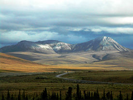
The highway begins about 40 km (24.9 mi) east of Dawson City, Yukon on the Klondike Highway and extends 736 km (457.3 mi) to Inuvik.
Much of the highway follows an old dog sled
Dog sled
A dog sled is a sled pulled by one or more sled dogs used to travel over ice and through snow. Numerous types of sleds are used, depending on their function. They can be used for dog sled racing.-History:...
trail. The highway is named after Royal Canadian Mounted Police
Royal Canadian Mounted Police
The Royal Canadian Mounted Police , literally ‘Royal Gendarmerie of Canada’; colloquially known as The Mounties, and internally as ‘The Force’) is the national police force of Canada, and one of the most recognized of its kind in the world. It is unique in the world as a national, federal,...
Inspector William Dempster, who, as a young constable, frequently ran the dog sled trail from Dawson City to Fort McPherson
Fort McPherson, Northwest Territories
Fort McPherson is a hamlet located in the Inuvik Region of the Northwest Territories, Canada. It is located on the east bank of the Peel River and is south of Inuvik on the Dempster Highway....
NWT.
Inspector Dempster and two other constables were sent out on a rescue patrol in March 1911, to find Inspector Fancis J. Fitzgerald and his men of three who never made it to Dawson City. They had become lost on the trail, and subsequently died of exposure and starvation. Dempster and his men found the bodies on March 22, 1911.
History
In 1958 the Canadian governmentGovernment of Canada
The Government of Canada, formally Her Majesty's Government, is the system whereby the federation of Canada is administered by a common authority; in Canadian English, the term can mean either the collective set of institutions or specifically the Queen-in-Council...
made the historic decision to build a 671 km (416.9 mi) road through the Arctic
Arctic
The Arctic is a region located at the northern-most part of the Earth. The Arctic consists of the Arctic Ocean and parts of Canada, Russia, Greenland, the United States, Norway, Sweden, Finland, and Iceland. The Arctic region consists of a vast, ice-covered ocean, surrounded by treeless permafrost...
wilderness from Dawson City to Inuvik. Oil and gas exploration was booming in the Mackenzie Delta and the town of Inuvik was under construction. The road was billed as the first-ever overland supply link to southern Canada, where business and political circles buzzed with talk of an oil pipeline that would run parallel to the road. The two would ultimately connect with another proposed pipeline along the Alaska Highway
Alaska Highway
The Alaska Highway was constructed during World War II for the purpose of connecting the contiguous U.S. to Alaska through Canada. It begins at the junction with several Canadian highways in Dawson Creek, British Columbia and runs to Delta Junction, Alaska, via Whitehorse, Yukon...
.
On 17 August 1959, Ottawa
Politics of Canada
The politics of Canada function within a framework of parliamentary democracy and a federal system of parliamentary government with strong democratic traditions. Canada is a constitutional monarchy, in which the Monarch is head of state...
announced that oil had been discovered in the territory’s Eagle Plains and, almost immediately, the government gave major concessions to the oil industry in an attempt to stimulate more exploration in the area. It was realised that a highway across the Arctic Circle
Arctic Circle
The Arctic Circle is one of the five major circles of latitude that mark maps of the Earth. For Epoch 2011, it is the parallel of latitude that runs north of the Equator....
would be needed to transport equipment, infrastructure and revenue to and from the sites. Consequently, construction began at Dawson City in January 1959. However, the highway's high costs, in addition to ongoing wrangling between the federal and Yukon governments kept progress at a snail’s pace until 1961, when building stopped altogether. Only 115 km (71.5 mi) of roadbed had been built before the project was abandoned. The route was known as Highway 11 until 1978.
There were no more developments until 1968, when a discovery of huge reserves of oil and gas at Prudhoe Bay
Prudhoe Bay, Alaska
Prudhoe Bay or Sagavanirktok is a census-designated place located in North Slope Borough in the U.S. state of Alaska. As of the 2010 census, the population of the CDP was 2,174 people; however, at any given time several thousand transient workers support the Prudhoe Bay oil field...
, Alaska
Alaska
Alaska is the largest state in the United States by area. It is situated in the northwest extremity of the North American continent, with Canada to the east, the Arctic Ocean to the north, and the Pacific Ocean to the west and south, with Russia further west across the Bering Strait...
was made. This led to increased competition between the authorities in America
United States
The United States of America is a federal constitutional republic comprising fifty states and a federal district...
and Canada. Billions of dollars were at stake, and political fortunes hung in the balance on both sides of the border. The Canadian government was afraid that the United States would develop the massive oil field with no consultation, no consideration and no benefits to its next-door neighbour. It wanted to assert Canadian sovereignty over the Arctic seabed
Arctic Ocean
The Arctic Ocean, located in the Northern Hemisphere and mostly in the Arctic north polar region, is the smallest and shallowest of the world's five major oceanic divisions...
off the Yukon's north coast in the Beaufort Sea
Beaufort Sea
The Beaufort Sea is a marginal sea of the Arctic Ocean, located north of the Northwest Territories, the Yukon, and Alaska, west of Canada's Arctic islands. The sea is named after hydrographer Sir Francis Beaufort...
, and over the waters
Territorial claims in the Arctic
Under international law, no country currently owns the North Pole or the region of the Arctic Ocean surrounding it. The five surrounding Arctic states, Russia, the United States, Canada, Norway and Denmark , are limited to an exclusive economic zone of adjacent to their coasts.Upon ratification...
among the Arctic islands
Canadian Arctic Archipelago
The Canadian Arctic Archipelago, also known as the Arctic Archipelago, is a Canadian archipelago north of the Canadian mainland in the Arctic...
which, though claimed by Canada, were asserted by the United States as high seas.
Construction
The Dempster Highway—Canada’s only all-weather road to cross the Arctic Circle—was officially opened on 18 August 1979, at Flat Creek, Yukon. It was unveiled as a two-lane, gravel-surfaced, all-weather highway that ran 671 km (416.9 mi) from the Klondike Highway near Dawson City to Fort McPherson and Arctic Red River (now TsiigehtchicTsiigehtchic, Northwest Territories
Tsiigehtchic is a Gwich’in community located at the confluence of the Mackenzie and the Arctic Red River, in the Inuvik Region of the Northwest Territories, Canada. The community was formerly known as Arctic Red River, until 1 April 1994.Population is 175 according to the 2006 Census...
) in the Northwest Territories. The Canadian Forces
Canadian Forces
The Canadian Forces , officially the Canadian Armed Forces , are the unified armed forces of Canada, as constituted by the National Defence Act, which states: "The Canadian Forces are the armed forces of Her Majesty raised by Canada and consist of one Service called the Canadian Armed Forces."...
1 Combat Engineer Regiment
1 Combat Engineer Regiment (Canada)
1 Combat Engineer Regiment is a regular force regiment of the Canadian Military Engineers commanded by a lieutenant-colonel. It is currently located in the Patton Building at CFB Edmonton , Alberta, and is assigned to 1 Canadian Mechanized Brigade Group.-Organization:-Armoured engineers:1 CER is...
from Chilliwack
Chilliwack, British Columbia
Chilliwack is a Canadian city in the Province of British Columbia. It is a predominantly agricultural community with an estimated population of 80,000 people. Chilliwack is the second largest city in the Fraser Valley Regional District after Abbotsford. The city is surrounded by mountains and...
, British Columbia
British Columbia
British Columbia is the westernmost of Canada's provinces and is known for its natural beauty, as reflected in its Latin motto, Splendor sine occasu . Its name was chosen by Queen Victoria in 1858...
, built the two major bridges over the Ogilvie and Eagle rivers. Ferries handle the traffic at the Peel River crossing near Fort McPherson
Fort McPherson, Northwest Territories
Fort McPherson is a hamlet located in the Inuvik Region of the Northwest Territories, Canada. It is located on the east bank of the Peel River and is south of Inuvik on the Dempster Highway....
and the Arctic Red River
Arctic Red River
The Arctic Red River is the name of a tributary to the Mackenzie River in the Northwest Territories, Canada.In 1993 the river was designated as part of the Canadian Heritage Rivers System. It was also the name of a community on the Mackenzie where the river joins, now known as Tsiigehtchic...
crossing near Tsiigehtchic.
The design of the highway is unique, primarily due to the intense physical conditions it is put through. The highway itself sits on top of a gravel berm
Berm
A berm is a level space, shelf, or raised barrier separating two areas. Berm originates in the Middle Dutch and German berme and came into usage in English via French.- History :...
to insulate the permafrost
Permafrost
In geology, permafrost, cryotic soil or permafrost soil is soil at or below the freezing point of water for two or more years. Ice is not always present, as may be in the case of nonporous bedrock, but it frequently occurs and it may be in amounts exceeding the potential hydraulic saturation of...
in the soil underneath. The thickness of the gravel pad ranges from 1.2 m (3.9 ft) up to 2.4 m (7.9 ft) in some places. Without the pad, the permafrost would melt and the road would sink into the ground.
In addition to services in Fort McPherson, Tsiigehtchic and Inuvik, there is one location with commercial services along the highway, at Eagle Plains. It is an important fuel and food stop because of the great distance, and harbours stranded travelers when the highway is closed due to extreme weather conditions. (Until 1979, the highway was only open in summer.)
During the early 1990s, Northwestel
Northwestel
Northwestel Inc. is the incumbent local exchange carrier and long distance carrier in Northern Canada. The company name is a portmanteau, sometimes spelled NorthwesTel, for Northwest Telecommunications.-Modern corporate history:...
erected microwave towers along the highway to facilitate public safety with manual mobile telephone service
Mobile Telephone Service
The Mobile Telephone Service is a pre-cellular VHF radio system that links to the Public Switched Telephone Network . MTS was the radiotelephone equivalent of land dial phone service. , only rural and wilderness areas were still using the system....
and to provide government agencies such as highway maintenance and the Royal Canadian Mounted Police with communications. The microwave project was opposed by some environmental interests and those who preferred the pristine appearance of the route. A suggestion to install fibre optics would not have enabled mobile communications. Since then, the route has become the terrestrial link to the exchanges in the Mackenzie Delta region.
Upon winning the spring 2011 election, the Prime Minister of Canada Stephen Harper announced that it was his intention to complete the highway to Tuktoyuktok but did not provide a definite timeline.