
.gif)
Peace River (Canada)
Encyclopedia
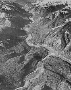
The Peace River is a river
in Canada
that originates in the Rocky Mountains
of northern British Columbia
and flows to the northeast through northern Alberta
. The Peace River flows into the Slave River
, a tributary of the Mackenzie River
. The Mackenzie is the 12th longest river in the world, preceded by the Mekong
and followed by the Niger River
. The Finlay River
, the main headwater of the Peace River, is regarded as the ultimate source of the Mackenzie River.
r Peter Pond
is believed to have visited the river in 1785. In 1788 Charles Boyer
of the North West Company
established a fur trading post at the river's junction with the Boyer River.
In 1792 and 1793, the explorer Alexander Mackenzie travelled up the river to the Continental Divide
. Mackenzie referred to the river as Unjegah, from a native word meaning "large river". The Peace River, or Unchaga or Unjaja, was named after Peace Point near Lake Athabasca
, where the Treaty of the Peace was celebrated by the smoking of a peace pipe. The treaty ended the decades of hostilities between the Beaver
(Athapascan branch) and the Cree
, in which the Cree dominated the Dane-zaa until a smallpox epidemic
in 1781 decimated the Cree. The treaty made the Peace River a border, with the Dane-zaa to the North and the Cree to the South.
In 1794, a fur trading post was built on the Peace River at Fort St. John
; it was the first non-native settlement on the British Columbia mainland.
The rich soils of the Peace River valley in Alberta have been producing wheat
crops since the late 19th century. The Peace River region is also an important centre of oil
and natural gas
production. There are also pulp
and paper plants along the river in British Columbia.
to Lake Athabasca
). It drains an area of approximately 302,500 km2. At Peace Point, where it drains in the Slave River
, it has an annual discharge of 2161 m3/s or 68,200,000 dam3/a.
 A large man-made lake, Williston Lake
, has been formed on the upper river by the construction of the W. A. C. Bennett Dam
for hydroelectric power generation. The river then flows into Dinosaur Lake, which serves as a reservoir for the Peace Canyon Dam
. After the dams, the river flows east into Alberta and then continues north and east into the Peace-Athabasca Delta
in Wood Buffalo National Park
, at the western end of Lake Athabasca
. Water from the delta flows into the Slave River
east of Peace Point and reaches the Arctic Ocean
via the Great Slave Lake
and Mackenzie River
.
Many provincial park
s and wildland reserves are established on the river, such as Butler Ridge Provincial Park
, Taylor Landing Provincial Park
, Beatton River Provincial Park
, Peace River Corridor Provincial Park
in British Columbia and Dunvegan Provincial Park
, Dunvegan West Wildland, Peace River Wildland Provincial Park
, Greene Valley Provincial Park
, Notikewin Provincial Park
, Wood Buffalo National Park
in Alberta.
A few Indian reserve
s are also located on the river banks, among them Beaver Ranch 163, John D'Or Prairie 215, Fox Lake 162, Peace Point 222 and Devil's Gate 220.
Williston Lake
Northeastern British Columbia
Alberta
Lake Claire
River
A river is a natural watercourse, usually freshwater, flowing towards an ocean, a lake, a sea, or another river. In a few cases, a river simply flows into the ground or dries up completely before reaching another body of water. Small rivers may also be called by several other names, including...
in Canada
Canada
Canada is a North American country consisting of ten provinces and three territories. Located in the northern part of the continent, it extends from the Atlantic Ocean in the east to the Pacific Ocean in the west, and northward into the Arctic Ocean...
that originates in the Rocky Mountains
Rocky Mountains
The Rocky Mountains are a major mountain range in western North America. The Rocky Mountains stretch more than from the northernmost part of British Columbia, in western Canada, to New Mexico, in the southwestern United States...
of northern British Columbia
British Columbia
British Columbia is the westernmost of Canada's provinces and is known for its natural beauty, as reflected in its Latin motto, Splendor sine occasu . Its name was chosen by Queen Victoria in 1858...
and flows to the northeast through northern Alberta
Alberta
Alberta is a province of Canada. It had an estimated population of 3.7 million in 2010 making it the most populous of Canada's three prairie provinces...
. The Peace River flows into the Slave River
Slave River
The Slave River is a Canadian river that flows from Lake Athabasca in northeastern Alberta and empties into Great Slave Lake in the Northwest Territories....
, a tributary of the Mackenzie River
Mackenzie River
The Mackenzie River is the largest river system in Canada. It flows through a vast, isolated region of forest and tundra entirely within the country's Northwest Territories, although its many tributaries reach into four other Canadian provinces and territories...
. The Mackenzie is the 12th longest river in the world, preceded by the Mekong
Mekong
The Mekong is a river that runs through China, Burma, Laos, Thailand, Cambodia and Vietnam. It is the world's 10th-longest river and the 7th-longest in Asia. Its estimated length is , and it drains an area of , discharging of water annually....
and followed by the Niger River
Niger River
The Niger River is the principal river of western Africa, extending about . Its drainage basin is in area. Its source is in the Guinea Highlands in southeastern Guinea...
. The Finlay River
Finlay River
The Finlay River is a 402 km long river in north-central British Columbia flowing north and thence south from Thutade Lake in the Omineca Mountains to Williston Lake, the impounded waters of the Peace River formed by the completion of the W.A.C. Bennett Dam in 1968. Prior to this, the Finlay...
, the main headwater of the Peace River, is regarded as the ultimate source of the Mackenzie River.
History
The regions along the river are the traditional home of the Dane-zaa people, called the Beaver by the Europeans. The fur tradeFur trade
The fur trade is a worldwide industry dealing in the acquisition and sale of animal fur. Since the establishment of world market for in the early modern period furs of boreal, polar and cold temperate mammalian animals have been the most valued...
r Peter Pond
Peter Pond
Peter Pond was born in Milford, Connecticut. He was a soldier with a Connecticut regiment, a fur trader, a founding member of the North West Company, an explorer and a cartographer.-Biography:...
is believed to have visited the river in 1785. In 1788 Charles Boyer
Charles Boyer
Charles Boyer was a French actor who appeared in more than 80 films between 1920 and 1976. After receiving an education in drama, Boyer started on the stage, but he found success in movies during the 1930s. His memorable performances were among the era's most highly praised romantic dramas,...
of the North West Company
North West Company
The North West Company was a fur trading business headquartered in Montreal from 1779 to 1821. It competed with increasing success against the Hudson's Bay Company in what was to become Western Canada...
established a fur trading post at the river's junction with the Boyer River.
In 1792 and 1793, the explorer Alexander Mackenzie travelled up the river to the Continental Divide
Continental Divide
The Continental Divide of the Americas, or merely the Continental Gulf of Division or Great Divide, is the name given to the principal, and largely mountainous, hydrological divide of the Americas that separates the watersheds that drain into the Pacific Ocean from those river systems that drain...
. Mackenzie referred to the river as Unjegah, from a native word meaning "large river". The Peace River, or Unchaga or Unjaja, was named after Peace Point near Lake Athabasca
Lake Athabasca
Lake Athabasca is located in the northwest corner of Saskatchewan and the northeast corner of Alberta between 58° and 60° N.-History:The name in the Dene language originally referred only to the large delta formed by the confluence the Athabasca River at the southwest corner of the lake...
, where the Treaty of the Peace was celebrated by the smoking of a peace pipe. The treaty ended the decades of hostilities between the Beaver
Dunneza
The Dane-zaa are a First Nation of the large Athapaskan language group; their traditional territory is around the Peace River of the provinces of Alberta and British Columbia, Canada...
(Athapascan branch) and the Cree
Cree
The Cree are one of the largest groups of First Nations / Native Americans in North America, with 200,000 members living in Canada. In Canada, the major proportion of Cree live north and west of Lake Superior, in Ontario, Manitoba, Saskatchewan, Alberta and the Northwest Territories, although...
, in which the Cree dominated the Dane-zaa until a smallpox epidemic
North American smallpox epidemic
The 1775–1782 North American smallpox epidemic was a smallpox epidemic that spread across most of the continent of North America. The epidemic coincided with the years of the American Revolutionary War , which was gripping much of the continent from the colonies, western frontiers, and southern...
in 1781 decimated the Cree. The treaty made the Peace River a border, with the Dane-zaa to the North and the Cree to the South.
In 1794, a fur trading post was built on the Peace River at Fort St. John
Fort St. John, British Columbia
The City of Fort St. John is a city in northeastern British Columbia, Canada. A member municipality of the Peace River Regional District, the city covers an area of about 22 km² with 22,000 residents . Located at Mile 47, it is one of the largest cities along the Alaska Highway. Originally...
; it was the first non-native settlement on the British Columbia mainland.
The rich soils of the Peace River valley in Alberta have been producing wheat
Wheat
Wheat is a cereal grain, originally from the Levant region of the Near East, but now cultivated worldwide. In 2007 world production of wheat was 607 million tons, making it the third most-produced cereal after maize and rice...
crops since the late 19th century. The Peace River region is also an important centre of oil
Petroleum
Petroleum or crude oil is a naturally occurring, flammable liquid consisting of a complex mixture of hydrocarbons of various molecular weights and other liquid organic compounds, that are found in geologic formations beneath the Earth's surface. Petroleum is recovered mostly through oil drilling...
and natural gas
Natural gas
Natural gas is a naturally occurring gas mixture consisting primarily of methane, typically with 0–20% higher hydrocarbons . It is found associated with other hydrocarbon fuel, in coal beds, as methane clathrates, and is an important fuel source and a major feedstock for fertilizers.Most natural...
production. There are also pulp
Wood pulp
Pulp is a lignocellulosic fibrous material prepared by chemically or mechanically separating cellulose fibres from wood, fibre crops or waste paper. Wood pulp is the most common raw material in papermaking.-History:...
and paper plants along the river in British Columbia.
Course
This river is 1,923 km long (from the head of Finlay RiverFinlay River
The Finlay River is a 402 km long river in north-central British Columbia flowing north and thence south from Thutade Lake in the Omineca Mountains to Williston Lake, the impounded waters of the Peace River formed by the completion of the W.A.C. Bennett Dam in 1968. Prior to this, the Finlay...
to Lake Athabasca
Lake Athabasca
Lake Athabasca is located in the northwest corner of Saskatchewan and the northeast corner of Alberta between 58° and 60° N.-History:The name in the Dene language originally referred only to the large delta formed by the confluence the Athabasca River at the southwest corner of the lake...
). It drains an area of approximately 302,500 km2. At Peace Point, where it drains in the Slave River
Slave River
The Slave River is a Canadian river that flows from Lake Athabasca in northeastern Alberta and empties into Great Slave Lake in the Northwest Territories....
, it has an annual discharge of 2161 m3/s or 68,200,000 dam3/a.
Williston Lake
Williston Lake is a reservoir created by the W. A. C. Bennett Dam and is located in the Northern Interior of British Columbia, Canada.-Geography:...
, has been formed on the upper river by the construction of the W. A. C. Bennett Dam
W. A. C. Bennett Dam
The W. A. C. Bennett Dam is a large hydroelectric earthfill dam on the Peace River in northern British Columbia, Canada. The dam, located 19 kilometres west of Hudson's Hope, and 85 kilometres northwest of Chetwynd, is named after the late former premier W. A. C. Bennett, and came on-line in 1968...
for hydroelectric power generation. The river then flows into Dinosaur Lake, which serves as a reservoir for the Peace Canyon Dam
Peace Canyon Dam
The Peace Canyon Dam is a large hydroelectric dam on the Peace River in northern British Columbia, Canada. It is located southwest of Hudson's Hope, downstream from the W.A.C. Bennett Dam....
. After the dams, the river flows east into Alberta and then continues north and east into the Peace-Athabasca Delta
Peace-Athabasca Delta
The Peace–Athabasca Delta is a large freshwater, inland delta in northeastern Alberta located where the Peace and Athabasca Rivers join the Slave River at the western end of Lake Athabasca.-Conservation :...
in Wood Buffalo National Park
Wood Buffalo National Park
Wood Buffalo National Park, located in northeastern Alberta and southern Northwest Territories, is the largest national park in Canada at . The park was established in 1922 to protect the world's largest herd of free roaming Wood Bison, currently estimated at more than 5,000...
, at the western end of Lake Athabasca
Lake Athabasca
Lake Athabasca is located in the northwest corner of Saskatchewan and the northeast corner of Alberta between 58° and 60° N.-History:The name in the Dene language originally referred only to the large delta formed by the confluence the Athabasca River at the southwest corner of the lake...
. Water from the delta flows into the Slave River
Slave River
The Slave River is a Canadian river that flows from Lake Athabasca in northeastern Alberta and empties into Great Slave Lake in the Northwest Territories....
east of Peace Point and reaches the Arctic Ocean
Arctic Ocean
The Arctic Ocean, located in the Northern Hemisphere and mostly in the Arctic north polar region, is the smallest and shallowest of the world's five major oceanic divisions...
via the Great Slave Lake
Great Slave Lake
Great Slave Lake is the second-largest lake in the Northwest Territories of Canada , the deepest lake in North America at , and the ninth-largest lake in the world. It is long and wide. It covers an area of in the southern part of the territory. Its given volume ranges from to and up to ...
and Mackenzie River
Mackenzie River
The Mackenzie River is the largest river system in Canada. It flows through a vast, isolated region of forest and tundra entirely within the country's Northwest Territories, although its many tributaries reach into four other Canadian provinces and territories...
.
Communities
Communities located directly on the river include:- Hudson's Hope, British ColumbiaHudson's Hope, British ColumbiaHudson's Hope is a district municipality in northeastern British Columbia, Canada, in the Peace River Regional District. It covers an area of with a population of 1,157 people. Having been first settled in 1805, it is the third oldest community in the province, although it was not incorporated...
- Taylor, British ColumbiaTaylor, British ColumbiaThe District of Taylor is a small town in northeastern British Columbia, Canada, located on mile 36 of the Alaska Highway. Taylor, a member municipality of the Peace River Regional District, covers an area of about 17 km² with 1,380 residents. As it is just south of the much larger city of...
- Peace River, AlbertaPeace River, AlbertaPeace River is a town in northwestern Alberta, Canada, situated along the banks of the Peace River, at its confluence with the Smoky River, the Heart River and Pat's Creek. It is located northwest of Edmonton, and northeast of Grande Prairie, along Highway 2. The Peace River townsite is nearly ...
- Fort Vermilion, AlbertaFort Vermilion, AlbertaFort Vermilion is a hamlet in northern Alberta, Canada within Mackenzie County.Established in 1788, Fort Vermilion shares the title of oldest European settlement in Alberta with Fort Chipewyan. Fort Vermilion contains many modern amenities to serve its inhabitants as well as the surrounding rural...
Many provincial park
Provincial park
A provincial park is a park under the management of a provincial or territorial government in Canada.While provincial parks are not the same as national parks, their workings are very similar...
s and wildland reserves are established on the river, such as Butler Ridge Provincial Park
Butler Ridge Provincial Park
Butler Ridge Provincial Park is a provincial park in British Columbia, Canada. Located on the northern shore of the Peach Reach arm of Williston Lake, 20 km northwest of Hudson's Hope, the park covers an area of 6,694 ha...
, Taylor Landing Provincial Park
Taylor Landing Provincial Park
Taylor Landing Provincial Park is a provincial park in British Columbia, Canada....
, Beatton River Provincial Park
Beatton River Provincial Park
Beatton River Provincial Park is a provincial park in the Peace River Country of northeastern British Columbia, Canada.-External links:...
, Peace River Corridor Provincial Park
Peace River Corridor Provincial Park
Peace River Corridor Provincial Park is a 2014 ha provincial park in British Columbia, Canada.It is located on the banks of the Peace River, at the confluence with Kiskatinaw River, downstream from Taylor. It is in the Boreal White and Black Spruce biogeoclimatic zone within the Peace Lowlands...
in British Columbia and Dunvegan Provincial Park
Dunvegan Provincial Park
Dunvegan Provincial Park and Historic Dunvegan are a provincial park and a provincial historic site of Alberta located together on one site. They are located in Dunvegan, at the crossing of Peace River and Highway 2, between Rycroft and Fairview....
, Dunvegan West Wildland, Peace River Wildland Provincial Park
Peace River Wildland Provincial Park
Peace River Wildland Provincial Park is located in the valley of the Peace River stretching from Dunvegan Provincial Park to the Smoky River confluence and 30 kilometers upstream of the Smoky River valley. Also included in the park is the Spirit River valley at the confluence with the Peace...
, Greene Valley Provincial Park
Greene Valley Provincial Park
Greene Valley Provincial Park is a provincial park east of the Town of Peace River Alberta in the Northern Sunrise County. It was designated by the Provincial Government a provincial park on June 6, 2000....
, Notikewin Provincial Park
Notikewin Provincial Park
Notikewin Provincial Park is a provincial park located in northwestern Alberta, Canada, 37 km east of Manning.The park is located at the confluence of the Peace River and Notikewin River. Crummy Lake is also located in the park...
, Wood Buffalo National Park
Wood Buffalo National Park
Wood Buffalo National Park, located in northeastern Alberta and southern Northwest Territories, is the largest national park in Canada at . The park was established in 1922 to protect the world's largest herd of free roaming Wood Bison, currently estimated at more than 5,000...
in Alberta.
A few Indian reserve
Indian reserve
In Canada, an Indian reserve is specified by the Indian Act as a "tract of land, the legal title to which is vested in Her Majesty, that has been set apart by Her Majesty for the use and benefit of a band." The Act also specifies that land reserved for the use and benefit of a band which is not...
s are also located on the river banks, among them Beaver Ranch 163, John D'Or Prairie 215, Fox Lake 162, Peace Point 222 and Devil's Gate 220.
Tributaries
Tributaries of the Peace River include:Williston Lake
Williston Lake
Williston Lake is a reservoir created by the W. A. C. Bennett Dam and is located in the Northern Interior of British Columbia, Canada.-Geography:...
- Finlay RiverFinlay RiverThe Finlay River is a 402 km long river in north-central British Columbia flowing north and thence south from Thutade Lake in the Omineca Mountains to Williston Lake, the impounded waters of the Peace River formed by the completion of the W.A.C. Bennett Dam in 1968. Prior to this, the Finlay...
- Omineca RiverOmineca RiverOmineca River is a river in northern British Columbia, Canada. It flows into the Williston Lake, and is part of the Peace River basin. It was originally a tributary of the Finlay River before the creation of Lake Williston.-References:...
- Ingenika River
- Ospika RiverOspika RiverThe Ospika River is a river in the Northern Interior of British Columbia, Canada, rising in the Northern Rocky Mountains to the north of Lake Williston and flowing south to join that lake in the lower end of its Finlay Reach. Before the creation of that lake by the building of WAC Bennett Dam, it...
- Parsnip RiverParsnip RiverThe Parsnip River is a 240 km long river in central British Columbia, Canada. It flows generally north-westward from the Parsnip Glacier in the Hart Ranges to the Parsnip Reach of Williston Lake, formed by the impounding of the waters of the Peace River by the W.A.C. Bennett Dam in 1968...
- Manson RiverManson RiverManson River is a river located in the Omineca Country region of British Columbia. It flows north into Manson Arm, Williston Lake. The river is located south of Germansen Landing. It was first known as Manson Creek and was discovered in 1871 by Robert Howell. The river has been mined using...
- Nation River
- Clearwater Creek
- Nabesche River
- Carbon Creek
Northeastern British Columbia
- Gething Creek, Moosbar Creek, Johnson Creek, Starfish Creek, Bullrun Creek, Portage Creek, Maurice Creek, Lynx Creek, Farrell Creek
- Halfway RiverHalfway RiverHalfway River is a river in north-eastern British Columbia, Canada. It is a major tributary of the Peace River.The river originates in the Muskwa Ranges at an elevation of . It flows from Robb Lake, between Mount Kenny and Mount Robb, then flows east to Pink Mountain...
- Cache Creek, Wilder Creek, Tea Creek
- Moberly River
- Pine River
- Eight Mile Creek
- Beatton RiverBeatton RiverThe Beatton River is a tributary of the Peace River, flowing generally east, then south through north-eastern British Columbia, Canada. The river rises at Pink Mountain, about 10 km west of the Alaska Highway hamlet of the same name, and flows 240 km generally east, then south, draining into the...
- Doig RiverDoig RiverDoig River is a river in Alberta and northern British Columbia, Canada.It originates on the northern fringes of Peace River Country in northern Alberta, south of the Chinchaga Wildland Park, in the Halverson Ridge of the Clear Hills, then flows westwards into British Columbia...
- Blueberry RiverBlueberry River (British Columbia)The Blueberry River is a river in the Peace River Block of northeastern British Columbia, Canada. It is a tributary of the Beatton River, which is a tributary of the Peace River....
- Doig River
- Golata Creek, Mica Creek
- Kiskatinaw RiverKiskatinaw RiverKiskatinaw is a small river in north-eastern British Columbia, Canada.It is a tributary of the Peace River.Bearhole Lake Provincial Park and Protected Area is established around the headwaterd of the river, and One Island Lake Provincial Park is located on the middle course...
- Alces River
Alberta
- Moonlight Creek
- Pouce Coupe RiverPouce Coupe RiverPouce Coupe is a river in Alberta and British Columbia, Canada. It is a major tributary of the Peace River.Originating in Alberta's Saddle Hills County, it flows into British Columbia's Peace River Regional District, then returns in Alberta in Clear Hills County, where it empties into the Peace...
- Clear River
- Sneddon Creek
- Montagneuse River
- Fourth Creek, Hamelin Creek
- Ksituan River
- Hines Creek, Dunvegan Creek, Boucher Creek
- Leith River (Little Burnt River)
- Saddle River (Burnt River)
- Griffin Creek, Mcallister Creek, Strong Creek
- Smoky RiverSmoky RiverSmoky River is a river in western Alberta, Canada. It is a major tributary of the Peace River. The descriptive name refers to the presence of "smouldering beds of coal in the riverbank" noted by the Cree Indians....
- Heart RiverHeart River (Alberta)Heart River is a river in northern Alberta, Canada. It is a major tributary of the Peace River.The motto of the village of Nampa, Alberta is A Place close to the Heart, a reference to the river flowing through the community.-Course:...
- Pats Creek, Three Creeks, Carmon Creek
- Whitemud River
- Cadotte RiverCadotte RiverThe Cadotte River is a river in northern Alberta, Canada. It is a tributary of the Peace River.The river gives the name to the Cadotte Member, a stratigraphical unit oif the Western Canadian Sedimentary Basin.-Course:...
- Buchanan Creek, Keppler Creek
- Notikewin RiverNotikewin RiverNotikewin River is a river in northern Alberta, Canada. It is a tributary of the Peace River. The Notikewin Provincial Park is established at the mouth of the river.The name derives from nôtinikewin , the Cree word for "battle"...
- Scully Creek
- Wolverine River
- Buffalo River
- Keg River
- Steephill Creek
- Boyer River
- Caribou River
- Beaver Ranch Creek
- Wabasca RiverWabasca RiverWabasca River is a river in northern Alberta, Canada. It is a major tributary of the Peace River.It has a total drainage area of .-Course:...
- Lawrence River
- Mikkwa River (Little Red River)
- Dummy Creek, Waldo Creek
- Pakwanutik River
- Garden Creek, Drolet Creek, Swan River, Vermilion River, Trident Creek, Portage River
- Jackfish River
- Jodoin Creek
- Claire River
Lake Claire
- Lake ClaireLake Claire (Alberta)Lake Claire is the largest lake which is entirely in Alberta, Canada. It is located entirely in Wood Buffalo National Park, west of Lake Athabasca. It lies between the mouths of Peace River and Athabasca River, and is part of the Peace-Athabasca Delta system....
- Birch River
- McIvor River
- Mamawi Lake
- Baril River
- Chenal Des Quatre Fourches
- Revillon Coupe
- Scow Channel